Post Conjunction: Santa Maria to Cape York, The Journey to 'Spirit Point' |

  |
Post Conjunction: Santa Maria to Cape York, The Journey to 'Spirit Point' |
 May 18 2011, 09:25 PM May 18 2011, 09:25 PM
Post
#421
|
|
|
Senior Member  Group: Members Posts: 3516 Joined: 4-November 05 From: North Wales Member No.: 542 |
Oh, that's very nice Tesheiner! We could do with more like that now and again when we're groping around trying to make sense of the view. An excellent spinoff from your route map work.

|
 |
 
|
|
May 18 2011, 10:07 PM
Post
#422
|
|
 The Poet Dude Group: Moderator Posts: 5551 Joined: 15-March 04 From: Kendal, Cumbria, UK Member No.: 60 |
QUOTE (Tesheiner @ May 18 2011, 10:15 PM)  Here's the result. Oooh, I like that! I like that a lot! -------------------- |
|
|
|
|
May 20 2011, 07:55 AM
Post
#423
|
|
 Member Group: Members Posts: 578 Joined: 5-November 04 From: Denmark Member No.: 107 |
I like the latest MER report:
http://marsrovers.nasa.gov/mission/status_...ll.html#sol2600 QUOTE The plan ahead is more diving. I know they havde found water on Mars, but this is maybe exaggerating a bit 
-------------------- "I want to make as many people as possible feel like they are part of this adventure. We are going to give everybody a sense of what exploring the surface of another world is really like"
- Steven Squyres |
|
|
|
| Guest_Sunspot_* |
May 20 2011, 12:12 PM
Post
#424
|
|
Guests |
Was the last drive cut short?
|
|
|
|
|
May 20 2011, 12:31 PM
Post
#425
|
|
 Senior Member Group: Moderator Posts: 2262 Joined: 9-February 04 From: Melbourne - Oz Member No.: 16 |
No official word, but yes I think the drive did fault out. As I posted on Twitter yesterday the post drive imagery was taken much earlier that usual and 'fault' images were taken which, while usually in the image schedule but not normally actually taken.
James -------------------- |
|
|
|
|
May 20 2011, 01:35 PM
Post
#426
|
|
 Member Group: Members Posts: 710 Joined: 28-September 04 Member No.: 99 |
Nothing obvious in the stamps: No big rock, no large ripple, no visible slippage in the soil. Wonder what went wrong....
|
|
|
|
|
May 20 2011, 02:17 PM
Post
#427
|
|
 Member Group: Members Posts: 754 Joined: 9-February 07 Member No.: 1700 |
Will there be evidence near Endeavour Crater that the object that created it "splashed" into a body of water?
Is there a way to see evidence of a "splash" from MRO? |
|
|
|
|
May 20 2011, 02:33 PM
Post
#428
|
|
|
Senior Member Group: Moderator Posts: 4279 Joined: 19-April 05 From: .br at .es Member No.: 253 |
QUOTE (OWW @ May 20 2011, 03:35 PM) Nothing obvious in the stamps: No big rock, no large ripple, no visable slippage in the soil. Wonder what went wrong.... "Excessive" tilt is my guess. |
|
|
|
|
May 20 2011, 08:13 PM
Post
#429
|
|
|
Junior Member Group: Members Posts: 30 Joined: 7-March 04 Member No.: 51 |
QUOTE (Tesheiner @ May 20 2011, 02:33 PM) "Excessive" tilt is my guess. Turns out, per marsroverdriver, that it was an excessive cosmic ray - flipped a bit in a FPGA. My first post in almost 3 years. I lurk a lot.
|
|
|
|
|
May 20 2011, 09:08 PM
Post
#430
|
||
 Senior Member Group: Members Posts: 2173 Joined: 28-December 04 From: Florida, USA Member No.: 132 |
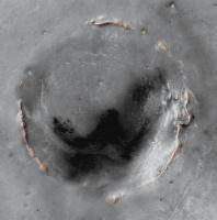
QUOTE (brellis @ May 20 2011, 09:17 AM) ...Is there a way to see evidence of a "splash" from MRO? My impression is that all we see of the original Endeavour Crater is what I have highlighted below -- the proverbial tip of the iceberg. The rest is covered by the Meridiani formation deposits. Not a lot to go on, but perhaps the fact that the rim seems to come to a sharp peak (in my view) is a hint -- of dry impact? Of course there are close to four billion years of weathering to take into account.
|
|
|
|
|
|
|
May 20 2011, 11:54 PM
Post
#431
|
|
|
Merciless Robot Group: Admin Posts: 8783 Joined: 8-December 05 From: Los Angeles Member No.: 602 |
To amplify, from Scott: "Last drive cut short (~ 30m) by a very rare Single-Event Upset (SEU) -- a cosmic ray flipped a bit in the FPGAs. Oppy's OK & driving again."
It do happen. -------------------- A few will take this knowledge and use this power of a dream realized as a force for change, an impetus for further discovery to make less ancient dreams real.
|
|
|
|
|
May 21 2011, 12:23 AM
Post
#432
|
|
|
Senior Member Group: Members Posts: 1582 Joined: 14-October 05 From: Vermont Member No.: 530 |
QUOTE (nprev @ May 20 2011, 07:54 PM) a cosmic ray flipped a bit in the FPGAs. Who needs an Alpha Magnetic Spectrometer? These rovers do it all. |
|
|
|
| Guest_Sunspot_* |
May 21 2011, 12:44 AM
Post
#433
|
|
Guests |
There is a small crater on the southern end of Cape York that could be interesting, if Opportunity can reach it though. Also there is a "ledge" or "shelf" that surrounds the Cape that perhaps the rover could drive around on.
|
|
|
|
|
May 21 2011, 01:27 AM
Post
#434
|
|
|
Senior Member Group: Members Posts: 1043 Joined: 17-February 09 Member No.: 4605 |
QUOTE (centsworth_II @ May 20 2011, 09:08 PM) My impression is that all we see of the original Endeavour Crater is what I have highlighted below...... The apparent sharpness of the peaks could be a function of upturned rim for a simple crater with any ejecta overlay eroded away. Endeavour seems to pre-date the Meridiani sediments and would surface water (implied by the Noachian channels to the south) have really affected the crater shape resulting from an impact into basaltic bedrock? There doesn't seem to be much hard information available for Endeavour as a whole. Do we have any real idea how deep are the sediments that have over-run the NW rim? |
|
|
|
|
May 23 2011, 08:27 PM
Post
#435
|
|
 Senior Member Group: Members Posts: 4246 Joined: 17-January 05 Member No.: 152 |
The pipeline's back. The new pics include this shot of a little crater imaged during the 2600 drive:
http://qt.exploratorium.edu/mars/opportuni...0M1.JPG?sol2600 |
|
|
|
|

|
Lo-Fi Version | Time is now: 25th April 2024 - 11:47 AM |
|
RULES AND GUIDELINES Please read the Forum Rules and Guidelines before posting. IMAGE COPYRIGHT |
OPINIONS AND MODERATION Opinions expressed on UnmannedSpaceflight.com are those of the individual posters and do not necessarily reflect the opinions of UnmannedSpaceflight.com or The Planetary Society. The all-volunteer UnmannedSpaceflight.com moderation team is wholly independent of The Planetary Society. The Planetary Society has no influence over decisions made by the UnmannedSpaceflight.com moderators. |
SUPPORT THE FORUM Unmannedspaceflight.com is funded by the Planetary Society. Please consider supporting our work and many other projects by donating to the Society or becoming a member. |
|