Geomorphology of Cape York and Solander Point, Examining Opportunity's destination at Endeavour Crater |

  |
Geomorphology of Cape York and Solander Point, Examining Opportunity's destination at Endeavour Crater |
 Aug 9 2011, 10:43 PM Aug 9 2011, 10:43 PM
Post
#106
|
|
 Member  Group: Members Posts: 699 Joined: 3-December 04 From: Boulder, Colorado, USA Member No.: 117 |
The ejecta from that crater would be *under* the Meridiani sediments, as it pre-dates them. We might see some sign of it on Cape York, though...
John |
 |
 
|
|
Aug 9 2011, 10:54 PM
Post
#107
|
|
 Member Group: Members Posts: 714 Joined: 3-January 08 Member No.: 3995 |
.
|
|
|
|
|
Aug 10 2011, 02:02 AM
Post
#108
|
|
|
Member Group: Members Posts: 146 Joined: 31-October 08 Member No.: 4473 |
It seems that Endeavor was created before most (if not all) of the Meridiani sediments were emplaced. The sections of exposed rim of Endeavor are essentially ejecta from the Endeavor impact. After that impact, the Meridiani sediments were laid down, perhaps with rounds of erosion in between. Did the raised rim sections get buried/eroded? Cape York sure looks like a piece of the rim that was long ago buried, and now is being exhumed. Other higher parts of the rim may or may not have been buried. Were these "islands" eroded by wind? water? ice? brine slime?
Note the Endeavor central plateau, with hundreds of meters of sediment, worn away most just inside the rim. It is amazing what can happen slowly if you've got a couple billion years... I've noticed that the sediment layering partially follows the slope -- not sure without better analysis. It is possible that the circumferential "zones" around Cape York may be more chemical in nature than structural. I.e, just different strength and chemistry of the matrix just due to original ionic groundwater diffusion from the older rim ejecta. We will soon see. I'm having great fun thinking about it all. |
|
|
|
|
Aug 10 2011, 02:10 AM
Post
#109
|
|
|
Member Group: Members Posts: 714 Joined: 3-January 08 Member No.: 3995 |
.
|
|
|
|
|
Aug 10 2011, 02:54 AM
Post
#110
|
|
|
Senior Member Group: Members Posts: 1043 Joined: 17-February 09 Member No.: 4605 |
Unfortunately almost all analysis published is concentrated on a small section of the western rim and the big picture of Endeavour and surrounds seems to receive little attention - or I may have missed the published data? With the exception of a couple of meteorites designated as having a Martian origin the ejecta we have passed has been displaced Meridiani sediment and the blocky ejecta just ahead will hopefully be our first opportunity to sample the ancient bedrock. The sediments have over-run the NW crater rim and part filled the crater so the original surface and overlaying Endeavour ejecta should be well buried, as John pointed out. The hematite response mapping indicates a high concentration inside the crater which would indicate that the mound is the ubiquitous cemented sulphates and that the crater has had significant water influence. But the mapping scale doesn't provide much discrimination.
Now that we can get a good look at the rim it seems well eroded. Is it ejecta or uplifted / overturned bedrock? The sediments seem to onlap the westerly side of the rim rather than being covered by material eroding from the rim and it would appear that there has been little erosion of the rim material since the sediments were laid down. So I tend to think that Mark's chemical alteration hypothesis for the terraces looks pretty good. We'll soon find out as Opportunity can now get back to being a geologist rather than a tourist. |
|
|
|
|
Aug 10 2011, 03:37 AM
Post
#111
|
|
|
Senior Member Group: Members Posts: 2998 Joined: 30-October 04 Member No.: 105 |
Agreed, Serpens.
At this point we can see as much sitting a few meters from the contact as we have seen a few kilometers above the site. We'll know more next week when we do get to the contact, but for the time being, closely evaluating this transition zone is important. We'll know more when we know it. I think the basic scenario here is simple. Endeavour crater was created on the basaltic basement and is unconformably overlain by the later aeolian/lacustrine (or, more properly, "playan") sediments of the Burns Fm. At this time, we don't know what the paleo-surface of the was like, nor what the many depositional or erosional environments that occurred over the billions of years between the "Endeavour Age" and the "Burns Age" are like. I feel certain that the CRISM phyllosilicate signature(s) are from an old weathering surface on the upturned basalt of the Endeavour rim, and more specifically, the nearby phyllo-signature is from weathered and covered ejecta from a crater in this weathering surface on the Cape York crest. Who knows, it may even be the "Betty Bluep" rocks we saw at Sata Maria or the elusive "5YR 4/3 outcrop" brown argillageous-looking outcrop we've seen along the way. These are interesting times... --Bill -------------------- |
|
|
|
|
Aug 12 2011, 09:25 PM
Post
#112
|
|
|
Member Group: Senior Member Posts: 136 Joined: 8-August 06 Member No.: 1022 |
QUOTE (centsworth_II @ Jul 19 2011, 11:56 AM)  Yes, but at one point the sulphate layers covered Cape York. They have been eroded away so I would expect to find blueberries that eroded out of the sulphate layers on Cape York but I would expect little left of the Sulphate layers themselves. As for why the Meridiani plains leading up to Cape York are higher, I guess it's just a matter of differential erosion rates due to the prevailing winds over the topography of the crater. While it is generally accepted that vast amounts of erosion of sediments over broad areas of the highlands has produced crater "mound" remnants like those in Endeavour, it isn't really true that sedimentary deposits are always deposited horizontally and continuously to their maximum elevation over a region. The martian polar layered deposits are a good, familiar example of a subaerial deposit that is thick but never (likely) extended across the northern plains to the elevation of their summit. The layers are also not horizontal. The Bahamas are an excellent, familiar example of a subaqueous deposit that is kilometers thick but never extended across the Atlantic Ocean basin. Once again, however, many on the MER project accept the model of extensive erosion of the Meridiani Planum sulfates. It will be interesting to see if there are blueberries on Cape York, indeed. If there aren't, it might suggest that Cape York was never buried by sulfates. But it also might be possible that the geochemistry of the groundwater within the rim rocks wasn't conducive to hematite concretion formation. It's a hypothesis!  -Tim. |
|
|
|
|
Aug 13 2011, 03:37 PM
Post
#113
|
|
|
Member Group: Members Posts: 146 Joined: 31-October 08 Member No.: 4473 |
One thing evident from the pictures of Cape York is a zone of "reduced topography" inside of, but concentric to, its boundary. One can speculate that this represents a "zone of alteration" of the original rim deposits after burial by the sulfate sediments.
The Odyssey crater is centered on the inner boundary of this zone, and indeed the northeast half of the rim debris is made up of larger (stronger) rocks, while the southeast half has almost no large rocks, presumably because the zone-of-alteration made debris from that side more friable. It is also possible that this zone represents an ancient soil layer in the rim deposits, and that role, rather than alteration by the subsequent Meridiani sulfates, made them more friable. The presence of obvious intrusive veins in the rocks currently under Oppy is another constraint on understanding things. Do the big rocks on the other side of Odyssey contain such veins? The remainder of Oppy's scientific functionality will be well-challenged to answer these questions. But we are indeed positioned to ask them. |
|
|
|
|
Aug 13 2011, 06:26 PM
Post
#114
|
|
 Member Group: Members Posts: 754 Joined: 9-February 07 Member No.: 1700 |
(edit: thinking ahead) Perhaps a spot can be found to park Oppy for the winter and point mini-TES at something interesting for a long time?
|
|
|
|
|
Aug 13 2011, 06:31 PM
Post
#115
|
|
|
Founder Group: Chairman Posts: 14432 Joined: 8-February 04 Member No.: 1 |
It's not integration time that's the problem. It's just contamination. It can't see out. It's filthy.
Mossbauer, on the other hand - that's just an integration time problem....so many weeks might be necessary. |
|
|
|
|
Aug 19 2011, 10:58 PM
Post
#116
|
|
|
Junior Member Group: Members Posts: 52 Joined: 1-March 11 From: Houston, USA Member No.: 5860 |
QUOTE (MarkG @ Aug 13 2011, 09:37 AM) The presence of obvious intrusive veins in the rocks currently under Oppy is another constraint on understanding things. Do the big rocks on the other side of Odyssey contain such veins? As kenny noted on August 14 in the Cape York thread, some of the large boulders may have split along veins. We now see Tisdale and at least one boulder east of it with a surface that may be what's left of veins they split along. So, pending confirmation that the light boulder surfaces are in fact equivalent to the veins in the ground, observations east of Odyssey to date are consistent with an answer of "yes". |
|
|
|
|
Oct 18 2011, 05:35 AM
Post
#117
|
||
 Senior Member Group: Members Posts: 2228 Joined: 1-December 04 From: Marble Falls, Texas, USA Member No.: 116 |
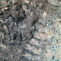
QUOTE (tim53 @ Aug 12 2011, 03:25 PM) ... It will be interesting to see if there are blueberries on Cape York, indeed. ... On sol 2748 a series of subframe images described as pancam_foreground were taken. Attached is an L456 false color composite from that series. I don't think we can say we see blueberries with certainty from this single image, but several of the pebbles in this image appear to be quite spherical and have approximately the right color to be the concretions.
Unfortunately, the R5 image has a large data dropout in the critical area, otherwise I could make a right filter, false color composite that could unambiguously identify hematite. I'll watch for the full R5 image to come down and will post the right filter composite when it does. -------------------- ...Tom
I'm not a Space Fan, I'm a Space Exploration Enthusiast. |
|
|
|
|
|
|
Oct 18 2011, 06:15 AM
Post
#118
|
|
|
Senior Member Group: Members Posts: 2998 Joined: 30-October 04 Member No.: 105 |
Try L257 and R721 images for this.
In this image set I've seen several nice rounded pebbles, but none that seemed unambigiously Blueberry-ish. We'll keep looking. --Bill PS-- I was going to put these on the Photobucket site tomorrow AM, but I decided to do 'em tonight. http://i142.photobucket.com/albums/r91/wil...00P2559L2M1.jpg http://i142.photobucket.com/albums/r91/wil...00P2559R7M1.jpg --b -------------------- |
|
|
|
|
Oct 19 2011, 02:07 PM
Post
#119
|
|
|
Senior Member Group: Members Posts: 2998 Joined: 30-October 04 Member No.: 105 |
QUOTE (CosmicRocker) If there is interest in the topic, we can start a thread in "Image Processing Techniques." Good idea. I'll get things moved.--Bill Topic split as requested - Image Enhancement for Mineral Identification - Moderator -------------------- |
|
|
|
|
Oct 19 2011, 03:23 PM
Post
#120
|
|
|
Senior Member Group: Members Posts: 2228 Joined: 1-December 04 From: Marble Falls, Texas, USA Member No.: 116 |
I think you split the posts at the wrong place. My original observation that blueberries may have been observed in the sol 2748 pancam_foreground images is highly relevant to the discussion of Cape York's geomorphology.
 A couple of posts moved back - Mod -------------------- ...Tom
I'm not a Space Fan, I'm a Space Exploration Enthusiast. |
|
|
|
|

|
Lo-Fi Version | Time is now: 2nd May 2024 - 11:30 PM |
|
RULES AND GUIDELINES Please read the Forum Rules and Guidelines before posting. IMAGE COPYRIGHT |
OPINIONS AND MODERATION Opinions expressed on UnmannedSpaceflight.com are those of the individual posters and do not necessarily reflect the opinions of UnmannedSpaceflight.com or The Planetary Society. The all-volunteer UnmannedSpaceflight.com moderation team is wholly independent of The Planetary Society. The Planetary Society has no influence over decisions made by the UnmannedSpaceflight.com moderators. |
SUPPORT THE FORUM Unmannedspaceflight.com is funded by the Planetary Society. Please consider supporting our work and many other projects by donating to the Society or becoming a member. |
|