Printable Version of Topic
Click here to view this topic in its original format
Unmanned Spaceflight.com _ MSL _ MSL - Stopover on the Road to Glenelg - Arm Commissioning
Posted by: elakdawalla Sep 5 2012, 06:21 PM
Rover drivers were tweeting yesterday that the 30.5-meter drive would be the last act of "Intermission." Sol 30 marks the start of Commissioning Activity Phase 2, when they'll check out the arm including MAHLI (yay) and, I think, scoop their first soil. As usual, keep discussion of previous images (through the navcam pan on sol 29) in the http://www.unmannedspaceflight.com/index.php?showtopic=7426&hl=.
Posted by: RoverDriver Sep 5 2012, 07:51 PM
I think scooping will be postponed.
Paolo
Posted by: Explorer1 Sep 5 2012, 08:02 PM
Any idea how close we are to Glenelg? There's no new route map, but since the terrain here is quite bland that's not a surprise.
Posted by: fredk Sep 5 2012, 08:38 PM
http://mars.jpl.nasa.gov/msl/news/whatsnew/index.cfm?FuseAction=ShowNews&NewsID=1334 (Total wheel turn distance, not crow-fly.) And Glenelg is about 400 m from the landing site.
Posted by: mhoward Sep 6 2012, 01:34 PM
Looks like the arm works. Okay, let's continue driving!  (I'm kidding, just kidding.)
|
Posted by: mhoward Sep 6 2012, 04:31 PM
Yay!
|

|
Posted by: Explorer1 Sep 6 2012, 04:55 PM
Visuals up for teleconference:
http://www.nasa.gov/mission_pages/msl/telecon/index.html
Wow!
A MAHLI team member is on the conference, so now would be a good time to ask about the possibility of self-portraits.
Posted by: nprev Sep 6 2012, 05:02 PM
My wife's comment on the pictures of the arm in action: "Is creation of genius."
Could not agree more. 
Posted by: djellison Sep 6 2012, 05:06 PM

We already know the answer. They're going to do it at some point.
During a first-time checkout of instruments is not the time.
Posted by: Explorer1 Sep 6 2012, 05:14 PM
Yeah, the video shows a belly-pan is going to happen very soon.
Posted by: Doc Sep 6 2012, 05:25 PM
Watching the teleconference... sol 33 seems to be the day for a MAHLI self-portrait(?)
Posted by: Doc Sep 6 2012, 05:33 PM
1 month or more till the first drill (no surprise there). The bright and semi-bright units at Glenelg will be the targets
Posted by: centsworth_II Sep 6 2012, 05:34 PM
Judging by Google images, this should be an evocative image .

|
Posted by: Doc Sep 6 2012, 05:37 PM
Distance travelled: 109m
Crow's distance: 82m
Posted by: mcaplinger Sep 6 2012, 05:38 PM
Depends on what you mean by self-portrait, but the belly pan is not what we think of as the self-portrait, nor do we call it the "MAHLI self-portrait" because it's not a self-portrait of MAHLI, but with MAHLI. Some people call the self-portrait of the rover taken with MAHLI the "Myspace image" but I'm too old to know what that means.

Posted by: Doc Sep 6 2012, 05:40 PM
"Reach for the stars..." ;-)
Posted by: Doc Sep 6 2012, 05:43 PM
Should have clarified... yeah I meant the belly pan though my ustream connection isn't as good as it should be so when I saw the MAHLI panning video I thought 'MAHLI will image Curiosity's portrait'
Posted by: volcanopele Sep 6 2012, 06:17 PM
Maybe this will help?
http://www.uahirise.org/releases/msl-tracks.php
Posted by: jmknapp Sep 6 2012, 06:51 PM
Leo Enright of Irish TV and of course Emily can always be counted on to ask the best questions at the telecons. From the one just concluded:
Michael Watkins: Umm, yeah, I think, so we've seen small dents before in our test rovers, you know, up in the Mars Yard and when you're driving around.So I think it's probably, it's pretty much as expected. I think that there's nothing unusual about that. So it may have been associated with the touchdown event or otherwise driving across, you know, some of the pebbles and cobbles and stuff. So we've seen that before and so we're obviously going to try to take reasonable care of the wheels, but nothing unusual so far.
Matt Robinson: Em, this is Matt. It's benign, it's nothing that would cause us any angst or worry about the performance of the wheels or driving.
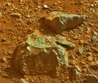
Joy Crisp: So this is Joy, uh, there's two main things that have intrigued me, and I think most of the team. One would be the MASTCAM imaging of Mount Sharp and seeing the structures and layers and we're not sure what it all means, but it's pretty spectacular and not something we've ever seen before on Mars, and the other would be the rocks nearby, some of them are showing quite amazing textures that we've not seen before on Mars, some that look like they might have big mineral grains in them that are light in tone and in a dark matrix, umm, just eye-popping but we don't know what it means, so we need to examine rocks like that more thoroughly close up to get at what... how those rocks formed. But that's whats been exciting, to see things that we've not seen on Mars before.
Posted by: xflare Sep 6 2012, 07:13 PM
I think this is the rock Joy Crisp is referring to
http://mars.jpl.nasa.gov/msl/multimedia/raw/?rawid=0024MR0119001000E1_DXXX&s=24
Posted by: elakdawalla Sep 6 2012, 07:17 PM
jmknapp, xflare, you've made my blog-writing job considerably easier today Thanks!
I had not noticed that rock. WOW.
Posted by: drz1111 Sep 6 2012, 08:17 PM
That rock looks like a dead ringer for a porphyritic basalt or andesite, with big ol' plag crystals. Its always dangerous to do armchair geology, but, wow.
Posted by: Ant103 Sep 6 2012, 10:04 PM
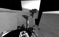
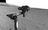
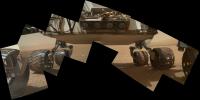
Sol 30 Navcams showing the extended robotic arm .
http://www.db-prods.net/marsroversimages/Curiosity/2012/Sol30_pano_roboticarm.jpg
Posted by: Eyesonmars Sep 6 2012, 10:25 PM
Not sure where to put this question but here goes ...
Could the brush on the arm be used to clean the dust off the rover (cameras, instruments, etc) if need be ?
Posted by: neo56 Sep 6 2012, 10:31 PM
According to this abstract : http://meetingorganizer.copernicus.org/EPSC2012/EPSC2012-326.pdf
an eclipse of the Sun by Phobos should occur inside the landing site ellipse on Sept 13, 16 and 17.
Does someone know if it is planned to image the Sun with the Navcam during these eclipses ?
Posted by: djellison Sep 6 2012, 10:41 PM
Could the brush on the arm be used to clean the dust off the rover (cameras, instruments, etc) if need be ?
I would not do that. It's an abrasive tool. It would do far more harm than good.
Posted by: Doc Sep 6 2012, 10:44 PM
http://mars.jpl.nasa.gov/msl/multimedia/raw/?rawid=0024MR0119001000E1_DXXX&s=24
Goodness!

Posted by: Joffan Sep 6 2012, 11:29 PM
. .
.Posted by: Deimos Sep 6 2012, 11:33 PM
Don't scare me like that!
Does someone know if it is planned to image the Sun with the Navcam during these eclipses ?
The 9/16 event is a near-miss. The 9/13 is a partial; 9/17 is annular but, shall we say, thermally challenging. It is possible these have come to the attention of the team, but no promises on outcome. And don't forget little Deimos!

Posted by: fredk Sep 6 2012, 11:36 PM
Posted by: Deimos Sep 6 2012, 11:43 PM
Neither have I.
Ah well, good things come to those who wait. (And maybe even to those who pester people until they get good things ...)
Posted by: Doc Sep 6 2012, 11:55 PM
Speaking of dented wheels, what exactly is the material used for Curiosity's wheels (heavy duty plastic or fiberglass)?
Posted by: nilstycho Sep 7 2012, 12:04 AM
http://mars.jpl.nasa.gov/msl/news/pdfs/MSLLanding.pdf
Posted by: jmknapp Sep 7 2012, 12:20 AM
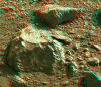
An anaglyph of the interesting rock:
|
The piece in the background seems to be the same stuff--maybe it broke off the base piece leaving the relatively fresh surface?
Posted by: Doc Sep 7 2012, 12:23 AM
Thanks nilstycho. Aluminium it is.
Posted by: Pando Sep 7 2012, 04:50 AM
Contrast and color enhanced to bring out some interesting features. There is definitely some slight greenish tinge present in that rock.
|
Posted by: Reckless Sep 7 2012, 09:18 AM
From sadly not a geologist, this looks a bit like andesite which on earth is often associated with tectonics but I noticed on Wikipedia that two meteorites were found with andesite in suggesting another method of producing it, maybe Curiosity has found another example.
I hope we get more information on this rock.
The meteorites in question are numbered GRA 06128 and GRA 06129 found in Alaska.
Roy
Posted by: elakdawalla Sep 7 2012, 04:04 PM
You have to be careful with casual rock identifications. There are two major things that affect an igneous rock's appearance: composition, and the rate at which it cooled. The terminology can be confusing. Basalt, andesite, and rhyolite have very different compositions but can have very similar looking textures because the texture is controlled more by the cooling rate than by composition; those three are the names for the rocks with fine-grained textures. The same magmas would produce gabbro, diorite, or granite (respectively) if allowed to cool more slowly. You can't tell just by looking at a rock from a distance whether it's basalt or andesite. On Earth, most of our oceanic crust is basalt, while most continental crustal rocks have bulk compositions closer to the rhyolite end (very little Mg, Fe, but lots of Al and Si and lighter metals like K and Na), so when you come across a new rock you have to entertain the entire possible range of compositions as possibilities. On Mars, basically everything has a basaltic bulk composition; the safe assumption is that it's basaltic until your chemical analysis instruments (either remote sensing or in situ) tell you otherwise.
To understand how you can make andesitic magmas from basaltic parent rocks, look up "partial melting" and "fractional crystallization." Nobody should make statements about igneous rock composition until you understand what those two terms mean!
Posted by: Zeke4ther Sep 7 2012, 05:52 PM
Thanks for that, Emily. I did a search and it was very enlightening.
Though the processes would be similar, it made me think just how alien the Martian environment is and how it would effect what we see.
Posted by: Doc Sep 7 2012, 06:14 PM
Judging from the size of the crystals, we can safely say that it is intrusive type of igneous. That at least should help identifying (or am I just kidding myself?)
We ought to keep a 'rock photojournal' for this voyage. I used to collect many rocks and id them when still a wee lad. Now its just MD for me 
Posted by: Don1 Sep 7 2012, 07:59 PM
Olivine is a green mineral.
Posted by: Pando Sep 7 2012, 08:01 PM
I am curious - would a smaller gravity on Mars have an effect on how the rocks are formed? Most of the assumptions about rock compositions are made based on Earth-based geology, but how closely does it translate to the environment on Mars?
Posted by: elakdawalla Sep 7 2012, 09:30 PM
Big crystals do have to form at depth, but you can have rocks with crystals that formed at depth but then the crystals were entrained in a liquid magma that reached the surface & cooled rapidly. (Look up "porphyritic")
The lower gravity doesn't change much, because most rocks form at depth under pressure. What does change is the depths at which certain kinds of rocks form. I was talking with some people who run a rock-squishing lab at APL and they told me their apparatus could crush rocks to the pressures encountered near the core of the Moon, at the base of the mantle of Mercury, but only in the upper mantle of Earth.
The lower air pressure does change the behavior of eruptions. On one end you get Venus where every kind of lava extrudes & doesn't explode; on the other end you get Io, where any trace of gas in a magma violently exsolves upon eruption, causing tall ash plumes. You'd expect volcanism on Mars to be more explosive than volcanism on Earth for that reason.
Posted by: ngunn Sep 7 2012, 10:12 PM
A brilliant and succinct explanation! I love the idea of a spectrum ranging from Venus to Io with all the other worlds in between.
Just one thing to add: liquids. Submarine eruptions here can find themselves in a Venus-like pressure regime. The same may once have been true on Mars.
EDIT: Maybe we should add Europa. What are eruptions like at the bottom of that ocean?
Posted by: dvandorn Sep 8 2012, 02:17 AM
Considering that Sojourner's APXS identified some of the rocks it examined in Ares Vallis as andesitic, I can understand how someone might look at a basaltic rock on Mars like the one we've been discussing, with such large crystals, and make a preliminary identification of andesite.
-the other Doug
Posted by: fredk Sep 8 2012, 04:13 AM
Hello there!
|
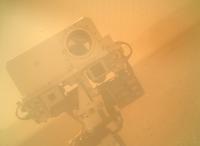
Posted by: Cargo Cult Sep 8 2012, 04:16 AM
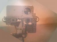
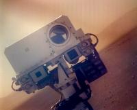
There's a http://mars.jpl.nasa.gov/msl/multimedia/raw/?rawid=0032MH0040000000E1_DXXX&s=32 up - just the camera mast, and upside-down and with the dust-covered lens-cover on, but it's most definitely a curious robot peering at itself.
(Quick https://hylobatidae.org/misc/msl-curiosity-self-portrait-20120907.jpg...)
Edit: fredk beat me to it. Still, it's a Martian robot!
Posted by: fredk Sep 8 2012, 04:42 AM
I do believe she winked at me...
|
Posted by: CosmicRocker Sep 8 2012, 04:49 AM
Posted by: Oersted Sep 8 2012, 05:52 AM
My take... Yup, contrast-stretching etc. means that lomography has come to Mars!
|
Posted by: gpurcell Sep 8 2012, 06:12 AM
My take switching into LAB space:
|
Posted by: MarsInMyLifetime Sep 8 2012, 07:06 AM
The original looked similar to issues with 40-year old color film I have successfully developed and recovered images from, so I used the same techniques: white balanced the most offensive color (the blue component), used a moderate stretch leaving the impression that we ARE looking through a dusty lens, applied a 3-pixel dust filter, resized smaller before sharpening (more apparent sharpness at that scale), and used a painting restorer's trick of using complementary flat colors to fill voids. I know we'll have a better image as soon as the dust cover is opened, but this left me feeling more like I was there--with dusty sunglasses.
|
(edit: re-associated the upload)
Posted by: Doc Sep 8 2012, 11:16 AM
Why would they need the LEDs in this case?
Posted by: Doc Sep 8 2012, 11:22 AM
Interesting... thanks for the education Emily.
Posted by: Juramike Sep 8 2012, 12:14 PM
Crystal size is a direct result of how fast the rock "solution" cooled. (In reality, it is more of a partial melt - I like the term "crystal mush").
Crystallization is all about competition. If you have a bunch of plagioclase molecular structures trying to crystallize out quickly you'll get a whole bunch of nucleation points all over the place. They compete with each other so that each nucleation site is trying to grab and assemble ions in the presence of a close neighbor. Lotsa competition, so the crystals stay really, really small. Many of them, but tiny.
If you have the same plag-containing mush but cool it very slowly, then you get only a few nucleation points. The ions in solution can leisurely find their way to the nucleation point and they have the time to be able to build up a big honkin' crystal. Only a few nucleation points, but really big crystals.
(For classifying grain sizes, it can be a sliding scale. During field work this summer we were using the term "granular groundmass dacite" for some of the teeny, but still evident, crystals under a 7x loupe. The official terms are dacite - no xtals present, and granodiorite - visible xtals present. All of these have the same composition range, it is just about crystal size, which is about crystalization speed, which is usually about depth.)
[[Really fun home experiment - make ice cream using liquid nitrogen. From what I've heard the smaller ice crystal size due to the uber-rapid cooling makes it totally dreamy.]]
Posted by: Juramike Sep 8 2012, 12:20 PM
Liquid nitrogen ice cream recipe here
http://chemistry.about.com/od/demonstrationsexperiments/ht/n2icecream.htm
Posted by: mcaplinger Sep 8 2012, 02:32 PM
To verify they were working. It also gives us some data on the dust loading on the cover.
Posted by: Ant103 Sep 8 2012, 02:53 PM
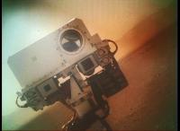
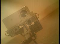
This self-portrait pic, it's an amazing shot ! I hope that they will do one other, with the MAHLI lens dust cover removed.
http://www.db-prods.net/marsroversimages/Curiosity/2012/0032MH0040000000E1_DXXX_corrected.jpeg
Posted by: mcaplinger Sep 8 2012, 03:29 PM
Thanks. Note on terminology: this isn't what we call the self-portrait. That's a multi-image mosaic of the whole rover taken with MAHLI, still in the planning process.
This image is usually nicknamed for a Pixar character that visually looked something like the RSM.
Posted by: markril Sep 8 2012, 06:47 PM
And, another:
|
Mark
Posted by: Nix Sep 8 2012, 07:44 PM
I just keep looking at that image.. so surreal... we've never had this view with Spirit & Oppy...
Posted by: Bill Harris Sep 9 2012, 01:32 AM
--Bill
Posted by: MahFL Sep 9 2012, 03:55 AM
Looks like a MAHLI full res with the dust cover open.
http://mars.jpl.nasa.gov/msl-raw-images/msss/00033/mhli/0033MH0070000000E1_DXXX.jpg
Posted by: mcaplinger Sep 9 2012, 04:14 AM
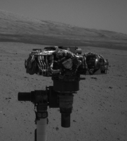
Many of sol 32's Mastcam turret inspection images are up also.
http://mars.jpl.nasa.gov/msl-raw-images/msss/00032/mcam/0032ML0069000000E1_DXXX.jpg
Posted by: ElkGroveDan Sep 9 2012, 04:19 AM
Wow that's beautiful, thanks for pointing it out Mike.
|
Posted by: NickF Sep 9 2012, 04:29 AM
Some interesting beasties from Sol 20
|
Posted by: neo56 Sep 9 2012, 08:57 AM
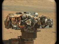
Wow ! A whole bunch of 22 new Mastcam34 photos of the suite of robotic arm instruments, and 96 thumbnails pictures:
http://mars.jpl.nasa.gov/msl/multimedia/raw/?s=32
Posted by: Doc Sep 9 2012, 09:30 AM
My take on MAHLI's on camera blink

|
Posted by: jmknapp Sep 9 2012, 09:40 AM
Has there been any report on preliminary results from the UV sensors on MSL? According to the press kit:
Posted by: neo56 Sep 9 2012, 09:54 AM
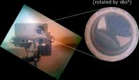
Have you noticed that we can see the martian surface on the mirror of Chemcam on the photo of the mast taken by MAHLI ?
In the attached picture, I highlighted what is seen by the Chemcam mirror (after a 180° rotation since it is a concave mirror). The martian surface is the light brown background. I guess that the dark structure we see at the foreground is the robotic arm.
|
Posted by: jmknapp Sep 9 2012, 10:55 AM
Seems like they'd want to take a closer look at something like that. I suppose that kind of rock could be volcanic?
Posted by: dvandorn Sep 9 2012, 12:59 PM
At first glance, the rocks in the image NickF posted look like vesicular gabbro with large vesicles, but I suppose they could be breccias in which softer clasts have eroded out, leaving the matrix with vesicle-like holes.
Interestingly, all of the other rocks in the image are heavily wind-eroded ventifacts, while the little pile of vesicular rocks are not nearly so obviously wind eroded. Maybe they haven't been in place for nearly as long?
-the other Doug
Posted by: eoincampbell Sep 9 2012, 02:52 PM
From those awesome turret inspection shots, anyone know what those curious little wire-framed orbs are that surround MAHLI & APXS ?
Posted by: elakdawalla Sep 9 2012, 03:05 PM
Those mechanically isolate APXS and MAHLI from the rest of the turret which has vibrating mechanisms for sieving soil.
Posted by: climber Sep 9 2012, 04:52 PM
I understand they are taking very cautious steps before opening MAHALI cap cover. One of the reason is because of dust/wind conditions so close to the ground. Does somebody knows, if the software will take in account wind measurement from other instrument to allow or not cap opening?
Posted by: neo56 Sep 9 2012, 05:22 PM
This image is usually nicknamed for a Pixar character that visually looked something like the RSM.
You mean a Pixar character like http://www.unmannedspaceflight.com/index.php?showtopic=7128&view=findpost&p=190983 ?

Posted by: xflare Sep 9 2012, 05:50 PM
http://mars.jpl.nasa.gov/msl/multimedia/raw/?rawid=0024MR0119001000E1_DXXX&s=24
And by an amazing coincedence... the MAHLI webpage at MSSS has this image of a rock taken by MAHLI during testing on Earth. It looks very similar to the one in the link above. It has the caption "This picture shows a MAHLI view of a portion of a rounded basalt cobble collected in Iceland by MAHLI Deputy Principal Investigator, Mike Malin. The large white-ish features are crystals of the mineral, plagioclase, that crystalized in the magma before the basalt lava was erupted onto the Earth’s surface. The holes in the cobble result from gas bubbles in that lava"
http://www.msss.com/science/msl-mahli-pre-launch-images.php Scroll down to the third image.
Posted by: Stu Sep 9 2012, 06:33 PM
Anyone else thinking "They look like they should all fit together..." ?
Posted by: elakdawalla Sep 9 2012, 07:01 PM
It seems like they should; which makes me try to imagine what exactly has happened over a billion years (give or take) to push the fragments very slightly apart.
Posted by: Stu Sep 9 2012, 07:05 PM
Doesn't that image just send shivers down your spine?
Posted by: john_s Sep 9 2012, 07:23 PM
Definitely weird to think about!
But are processes really that slow at this place on Mars? We're sitting next to a multi-kilometer mountain whose lower flanks have been heavily eroded- those layered sediments must have once extended much further out onto the floor of Gale, conceivably as far as the landing side. From that perspective, could there have actually been hundreds of meters, or more, of erosion here in the last couple of billion years?
John
Posted by: elakdawalla Sep 9 2012, 08:09 PM
You're right, it's likely not that slow -- in fact the most popular notion is that the mountain is the remnant of a deposit that once completely filled the crater (and other nearby craters as well). I'll cut three zeroes off the end of that number; it's still mind-boggling!
Posted by: ngunn Sep 9 2012, 10:37 PM
Maybe it just fell over and broke, like this: http://www.google.co.uk/imgres?imgurl=http://www.megalithic.co.uk/a558/a312/gallery/France/Brittany/Carnac_Area/grandmenhir_md.jpg&imgrefurl=http://www.megalithic.co.uk/article.php?sid%3D9311&h=305&w=812&sz=53&tbnid=dzQeipFVXiunwM:&tbnh=45&tbnw=120&zoom=1&usg=__y1qdy_-tg4yzxmEDHlZO-n3zKiI=&docid=Fxzeuvn6NiEHfM&sa=X&ei=fRlNUNiTBYLU0QXzsIDwAw&ved=0CC8Q9QEwAQ&dur=142
Posted by: jmknapp Sep 10 2012, 12:05 AM
Why not pumice, on the order of:

|
For that matter, could the layered sediments on Mt. Sharp be volcanic ash & pumice a la Tent Rocks:
http://www.abqartists.com/jaime-jordan/tent-rocks-ii-large.htm
Posted by: dvandorn Sep 10 2012, 01:53 AM
I said at first glance...
However, isn't pumice a rather weak, friable rock? This set of rocks doesn't look to be as wind-eroded as the vast majority of the rocks nearby. If it's pumice, wouldn't you think it had been emplaced here pretty recently, geologically speaking?
I'd love to examine it a little more closely, but I bet they don't want to get bogged down bringing Curiosity's tools to bear on every somewhat interesting-looking rock we come across. Especially this early in the campaign. We'll be seeing a *ton* of interesting rocks.
It's just so hard to be patient...
-the other Doug
Posted by: fredk Sep 10 2012, 02:31 AM
Posted by: Hungry4info Sep 10 2012, 03:45 AM
First MAHLI image without the dust cover.
http://mars.jpl.nasa.gov/msl/multimedia/raw/?rawid=0033MH0070000000E1_DXXX&s=33
I figure this is either a moon or an LED.
http://mars.jpl.nasa.gov/msl/multimedia/raw/?rawid=0033ML0008005000I1_DXXX&s=33
Posted by: mcaplinger Sep 10 2012, 04:03 AM
The sun, actually.
Posted by: Joffan Sep 10 2012, 04:04 AM
http://mars.jpl.nasa.gov/msl/multimedia/raw/?rawid=0033ML0008005000I1_DXXX&s=33
Edit to add... except I found that this picture was taken near to local solar noon.... so mcaplinger is undoubtedly correct.
Further edit.... and Jupiter is just past solar conjunction, from Mars. So not easy to capture an image of, at the moment.
Posted by: PDP8E Sep 10 2012, 04:28 AM
MAHLI has tossed off its lens cover!
I stacked both images but had to down-sample to fit into UMSF 1M upload limit (can I have that upped to 2M?)

|
Posted by: NickF Sep 10 2012, 04:29 AM
There are some stupendous MAHLI images of the rover underside and calibration target coming down
http://mars.jpl.nasa.gov/msl-raw-images/msss/00034/mhli/0034MH0066001000E1_DXXX.jpg
http://mars.jpl.nasa.gov/msl-raw-images/msss/00034/mhli/0034MH0063001000E1_DXXX.jpg
http://mars.jpl.nasa.gov/msl-raw-images/msss/00034/mhli/0034MH0045001000E1_DXXX.jpg
http://mars.jpl.nasa.gov/msl-raw-images/msss/00034/mhli/0034MH0046001000E1_DXXX.jpg
Posted by: fredk Sep 10 2012, 04:30 AM
Get the swear jar. This is insane.
http://mars.jpl.nasa.gov/msl-raw-images/msss/00034/mhli/0034MH0067001000E1_DXXX.jpg
http://mars.jpl.nasa.gov/msl-raw-images/msss/00034/mhli/0034MH0063001000E1_DXXX.jpg
http://mars.jpl.nasa.gov/msl-raw-images/msss/00034/mhli/0034MH0065001000E1_DXXX.jpg
And mastcam 100 view of the sun on its way...
http://mars.jpl.nasa.gov/msl-raw-images/msss/00033/mcam/0033MR0008004000I1_DXXX.jpg
Posted by: mcaplinger Sep 10 2012, 04:34 AM
That image was down and noted a couple of pages upthread. MAHLI data release is same day.
Posted by: fredk Sep 10 2012, 05:02 AM
I have to say that in all of my years of following Mars missions, nothing has given me the impression of being on the ground like these belly pan images. It's partly the insane level of detail - the dust and dents on the wheels, and the tracks and soil and cobbles below. But it's also the fact that the views continue into the landscape stretching off to the mountains behind. I don't have the words. We need a poet.
And I know I don't have to ask for a mosaic!
Posted by: elakdawalla Sep 10 2012, 05:46 AM
Your wish is my command 
https://planetary.s3.amazonaws.com/assets/images/4-mars/2012/20120909_msl_mahli_left-wheels_0034MH0066001000E1_DXXX-0034MH0067001000E1_DXXX.jpg
It'll be nice when these image releases come at the beginning of my day rather than the end! Only had time for a two-image pan before bed.
Posted by: Explorer1 Sep 10 2012, 06:33 AM
Wow!
Old Abe's already got a grain of dust on him.
And the wheels....
Posted by: Cargo Cult Sep 10 2012, 06:39 AM
Forget the cuddly, anthropomorphic shot of the mastcam from Friday - it's now a http://mars.jpl.nasa.gov/msl-raw-images/msss/00034/mhli/0034MH0059001000E1_DXXX.jpg!
Seeing the wheels on the surface of Mars is quite amazing.
Posted by: Stellingwerff Sep 10 2012, 06:43 AM
Ok, it looks terrible do to the amateur Hugin skills, the large translations between the shots, etc. But here is my early try.

|
Greetings,
Ludo.
Posted by: iMPREPREX Sep 10 2012, 07:04 AM
Oh man, that one above is so close to being perfect! Nice!
Awesome stuff. I think the MAHLI is my new best friend!
My try at a quick composite of the underside:

|
Posted by: walfy Sep 10 2012, 07:04 AM
Amazing shots of the underbelly!
Besides the waving martian, there is some Greek lettering on the MAHLI calibration target: γδβγ
The letters are gdbg. Now there's a mystery!

|
Posted by: Astro0 Sep 10 2012, 08:09 AM
Well, might as well take a shot at it. Not perfect but you get the idea

|
Full version on my http://astro0.files.wordpress.com/2012/09/mahli_underbellypan_sol34.jpg: 5.85mb (6437 x 3200)
EDIT: http://www.unmannedspaceflight.com/index.php?showtopic=7454&view=findpost&p=191067 on my http://astro0.files.wordpress.com/2012/09/mahli_underbellypan_sol341.jpg: 6.34mb [6675 x 3200]
Posted by: DeanM Sep 10 2012, 08:25 AM
walfy: The letters are gdbg. Now there's a mystery!
As an Aussie, these things aren't 100% clear to me, but GDBG appears to be some kind of Caltech fraternity
with an interesting and probably unique 'constitution':"No major uncools".
http://www.gdbg.org/blacker.faq.html
"Why Gamma Delta Beta Gamma?"
In the late 1970s Blacker was heavy into elevator trolling and keys. One day a few Moles lead by Charles Scott Reynolds (fr: 1975) were sitting on top of an elevator. Some security guards came in and happened to use that elevator. The guards were complaining about something that the "God Damned Blacker Gang" had done (contemporaries confirm that it was "Gang" and not "Guys" as some versions of the story have mentioned). So the next Blacker RF was signed with "Gamma Delta Beta Gamma"... "
So, which Caltech aluminus (& you know who you are!) wants to 'fess up?!
Dean
[Reason for edit: spulling!]

|
Posted by: iMPREPREX Sep 10 2012, 08:47 AM
Full version on my http://astro0.files.wordpress.com/2012/09/mahli_underbellypan_sol34.jpg: 5.85mb (6437 x 3200)
That's almost perfect! Probably the best we'll be able to get! Bravo!

Posted by: jmknapp Sep 10 2012, 09:57 AM
Beats me! I was just going by an impression without any specific geological knowledge. It's hard enough trying to follow (unsuccessfully) eons of geological processes on earth without throwing another planet into the mix. But there could be little water erosion involved, and as for wind erosion, who's to say how these fragments started? Also, volcanic activity could be relatively recent.
Another impression is that Mars seems to continually throw curveballs at Earth interpreters, from Lowell on down, who hope that there's a warm, wet planet in there somewhere. For example, Gusev Crater was supposed to be a "slam dunk" to be floored with ancient lake sediments but turned out to be another case of volcanic deposits & Spirit had to go to plan B.
I wonder how is it known that Gale Crater formed by an impact rather than, say, by volcanic processes a la http://en.wikipedia.org/wiki/Mount_Mazama, maybe without the lake? Doing a quick Google search gives this reference http://scholarsarchive.library.oregonstate.edu/xmlui/bitstream/handle/1957/6151/SR%20no.%20268%20ocr.pdf?sequence=1 that mentions clays, phyllosilicates etc. coming from pumice deposits from Mt. Mazama at Crater Lake, Oregon.
Posted by: jvandriel Sep 10 2012, 10:45 AM
Sol 34 Panorama Underside of Curiosity.
Jan van Driel
|
Posted by: Ant103 Sep 10 2012, 11:32 AM
I think I have no words
This is just
Wow.
http://www.db-prods.net/marsroversimages/curiosity.html#sol34
Thanks to the MSSS team, you're the best
Posted by: DeanM Sep 10 2012, 12:29 PM
Walfy:
How on Earth (or even elsewhere!) could you have possibly known a priori to look in great detail for "some Greek lettering on the MAHLI calibration target" & 'found' γδβγ ?!
Share!
Dean
Posted by: Doc Sep 10 2012, 12:47 PM
What a perfect way of starting the day!
Posted by: Astro0 Sep 10 2012, 12:52 PM
Had a little extra time this evening to add an extra frame and fix a rear wheel.
Note: some dodgy squishy/stretchy stuff to make a pretty picture.
I'll let JPL and MSSS worry about the science 

|
Large version on my blog: http://astro0.files.wordpress.com/2012/09/mahli_underbellypan_sol341.jpg [6675 x 3200]
Posted by: mcaplinger Sep 10 2012, 01:23 PM
Hint: Blacker House is an undergraduate house. http://en.wikipedia.org/wiki/House_System_at_the_California_Institute_of_Technology
Other related item: here's an extreme closeup of the MMM focal plane board, on the opposite side from the CCD:

I didn't go to Caltech so I only look on these things with bemusement.
Posted by: Doc Sep 10 2012, 01:57 PM
Made a gif animation of a depth test. Here they focus on the calibration panel going outwards...
|
Posted by: dombili Sep 10 2012, 02:23 PM
Hey fellas, I have a quick question. I'm sorry if this sounds stupid, but there are some small black dots on the images that MAHLI has sent. Can anybody elaborate as to what they could be? Since the same dots are present on almost every image, it's obvious that the problem caused by the camera. It's probably nothing, but I'm just curious
Examples: http://i.imgur.com/Pc7No.jpg - http://mars.jpl.nasa.gov/msl-raw-images/msss/00033/mhli/0033MH0069000000E2_DXXX.jpg - http://mars.jpl.nasa.gov/msl-raw-images/msss/00034/mhli/0034MH0044002000E1_DXXX.jpg - http://mars.jpl.nasa.gov/msl-raw-images/msss/00034/mhli/0034MH0065001000E1_DXXX.jpg
Posted by: jmknapp Sep 10 2012, 02:27 PM
A try at a MAHLI stereo anaglyph:
|
News this morning:
http://www.csmonitor.com/Science/2012/0910/Scientists-fear-Curiosity-rover-drill-bits-could-contaminate-Mars
Conleys predecessor at NASA, John D. Rummel, a professor of biology at East Carolina University, said, partly in jest: It will be a sad day for NASA if they do detect ice or water. Thats because the Curiosity project will most likely be told, Gee, thats nice. Now turn around.
If water is found, Curiosity could still conduct tests from a distance with instruments including a laser and spectrometers.
Posted by: mcaplinger Sep 10 2012, 02:41 PM
They're fragments of uralane threadlock that got on the CCD microlenses and couldn't be removed. (That's the last time we use that material in that application.) I'm working on an algorithm, similar to the old vidicon reseau removal algorithm, to cosmetically remove them.
Posted by: Paul Fjeld Sep 10 2012, 03:45 PM
http://www.csmonitor.com/Science/2012/0910/Scientists-fear-Curiosity-rover-drill-bits-could-contaminate-Mars
This is confusing. Wasn't Phoenix about finding the water? Did its landing gear contaminate the site any less than the wheels of Curiosity? I remember Viking had a "cook out" of its guts once it was encapsulated. Didn't NASA do something similar with MSL?
Posted by: Paul Fjeld Sep 10 2012, 03:55 PM
Note: some dodgy squishy/stretchy stuff to make a pretty picture.
Phenomenal! Interesting to see all the dings on the wheels, especially the dents showing through on the interior of the left most wheel (right front). The little rocks and pebbles are so sharp, they seem like little pickets guarding the pristine surface. The dust on the interior mid part of that wheel must have been blown in from landing. Or could it be dust squeezed through the little holes in the "JPL" section of the wheel that shifts as the wheel turns to coat the whole thing?
Posted by: marsman2020 Sep 10 2012, 04:22 PM
News this morning:
http://www.csmonitor.com/Science/2012/0910/Scientists-fear-Curiosity-rover-drill-bits-could-contaminate-Mars
MSL's sampling system never had a "bio barrier" like Phoenix. That decision was made not 6 months before launch but probably 6 years.
The "bit boxes" refer to the structures on the front panel that hold the 2 replacement bits. These structures, however, are not hermetically sealed. Neither was the location of the pre-installed drill bit on the turret. And no way the wheels were either. There was no sealed "box" to be opened accidentally.........because it wasn't part of the design. Ref. http://ntrs.nasa.gov/archive/nasa/casi.ntrs.nasa.gov/20100021927_2010023816.pdf, page 235 for a shot of the rover front panel with the bit boxes. They look exactly like what you can see in the photos from ATLO.
The statements by the HQ PP person don't reflect the physical flight hardware on MSL, and then the reporting by the LA Times confuses things even further. I can't make heads or tales of what this is all about. I'd hate to imply that the HQ PP people weren't paying attention to their flagship mission for years, but this was discussed in multiple review cycles and what flew was what was reviewed.
However, something else interesting happened in the last few sols - it appears from the photos that the CHIMRA sample processing system was put through it's paces on the end of the robotic arm. The Sol 32 MastCam photos show the scoop, sieve clearing "thwackers", and portioner door being opened up, and the internal sample-touching surfaces of CHIMRA being inspected with the 100mm MastCam (currently only thumbnails have come down). It looks like the "thwackers" were "thwacked" as well. Testing of the vibration had already been mentioned in a new update on the MSL website, so that hits all the actuated degrees of freedom on CHIMRA.
Posted by: iMPREPREX Sep 10 2012, 04:59 PM
Nice, my friend!
I, myself, stacked them and got this. It's not blurry in some places anymore.
3 of those images stacked:
|
Posted by: MahFL Sep 10 2012, 05:22 PM
Has anyone noted the strips of tape that seem to have been placed rather untidily behind and left of the calibration target ?
Posted by: stevesliva Sep 10 2012, 05:42 PM
The "bit boxes" refer to the structures on the front panel that hold the 2 replacement bits. These structures, however, are not hermetically sealed. Neither was the location of the pre-installed drill bit on the turret. And no way the wheels were either. There was no sealed "box" to be opened accidentally.........because it wasn't part of the design. Ref. http://ntrs.nasa.gov/archive/nasa/casi.ntrs.nasa.gov/20100021927_2010023816.pdf, page 235 for a shot of the rover front panel with the bit boxes. They look exactly like what you can see in the photos from ATLO.
The statements by the HQ PP person don't reflect the physical flight hardware on MSL, and then the reporting by the LA Times confuses things even further. I can't make heads or tales of what this is all about.
Can we leave it at this, at least in this thread? This is going to be mirrored by every tabloidish news source on the planet with stupid provocative headlines and even more distorted information, and at the next press conference, some engineer or scientist will sigh heavily and deal with questions about it.
Posted by: jmknapp Sep 10 2012, 06:45 PM
According to http://marsoweb.nas.nasa.gov/landingsites/msl/workshops/5th_workshop/talks/Tuesday_AM/Rummel_MSL_PP_Constraints.pdf, if MSL encounters "special regions" (e.g., water), then use of the "corer (or other sampling device)" should adhere to Planetary Protection Guidelines IVb, which state:
1. Either the entire landed system must be sterilized to the microbial burden levels defined in the specification sheet "Maximum Surface Microbial Spore Burden for Category IVb and IVc Missions to Mars," or to levels driven by the nature and sensitivity of the particular life-detection experiments, whichever are more stringent.
2. Or the subsystems that are involved in the acquisition, delivery, and analysis of samples used for life detection must be sterilized to burden levels defined in the specification sheet "Maximum Surface Microbial Spore Burden for Category IVb and IVc Missions to Mars" and a method of preventing recontamination of the sterilized subsystems and the contamination of the material to be analyzed is in place.
If a "special region" is not encountered (highly likely), then only category IVa applies:
This little snafu was covered by http://www.space.com/13783-nasa-msl-curiosity-mars-rover-planetary-protection.html last November & so it's old news.
Posted by: JayB Sep 10 2012, 07:33 PM
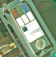
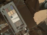
In case anyone (like me) was wondering about the penny http://mars.jpl.nasa.gov/msl/multimedia/images/?ImageID=4649
Posted by: Ron Hobbs Sep 10 2012, 10:17 PM
I am intrigued by Joe the Martian, which was explained in this release as well. Maybe we have a nickname for Curiosity.
Go, Joe the Martian!!
Posted by: vikingmars Sep 10 2012, 10:33 PM
My own interpretation... with manual stitch (a remembrance to Marcia Neugebauer's techniques at JPL !). Enjoy

|
Posted by: DeanM Sep 10 2012, 11:02 PM
Other related item: here's an extreme closeup of the MMM focal plane board, on the opposite side from the CCD:
I didn't go to Caltech so I only look on these things with bemusement.
The plot thickens!
"Dabney Hovse is the smallest of Caltech's Houses."
http://en.wikipedia.org/wiki/House_System_at_the_California_Institute_of_Technology
"Traditionally standing for "Dabney Eats It," referring to a particularly unpalatable plate of noodles in the 1950s, the trigraph DEI has come to be a badge of pride for Darbs. Besides naming the house's recreation room after it and spreading it all across campus, Dabney alumni have made DEI a hidden code in the outside world. The letters can be seen in movies (most notably Real Genius) and video games (including GTA: Vice City and several Intellivision games). There are even stories of the trigraph making its way into space on JPL probes including the Voyager space craft, and being written on the Moon by astronaut Darb Harrison Schmitt."
Marvellous stuff!
Dean
Posted by: jmknapp Sep 11 2012, 11:22 AM
On the UV sensors, the document http://www-mars.lmd.jussieu.fr/paris2011/abstracts/gomez-elvira_paris2011.pdf says:
FM Photodiodes have been calibrated before integration to know their spectral response at different temperatures, radiation intensity and incident angles. But once all photodiodes were integrated with the ICU, it was detected that for channels C and D the noise to signal ratios were very poor. For the other channels, the performance were the expected ones, inside the limits of its field-of-views.
Was that rectified before flight or is that the current status?
The Mars Weather page http://marsweather.com/first-rems-weather-report indicates that the UV sensors generally have been in operation:
I'm curious to know what the measured values indicate for the amount of sterilizing UV radiation hitting the surface, particularly now before the dust storm season kicks in. UVC is particularly the "germicidal" band.
Posted by: Ant103 Sep 11 2012, 12:53 PM
Olivier : Terrific work ! With so many parralax effects, it's hard to stitch such a mosaic.
Here is what I think my final version :
http://www.db-prods.net/marsroversimages/curiosity.html#sol34
Posted by: vikingmars Sep 11 2012, 01:57 PM
WOW ! Damien your mosaic is just greeeaaaat !
Besides, thanks a lot Damien : I had to do an (hell) manual stitching with hand-made (Paint shop) transforms for each image before "glueing" them together electronically, because automatic stitching trough softwares did not work at all to "glue" them all together. Well... I did it very much like the old JPL way done for photographs prints in the 80s'...
=> Your new mosaic deserves as many wheels as there are to be seen on your picture :

Posted by: Vanden Sep 11 2012, 02:03 PM
Ant103, vikingmars, Astro0 : awesome picture !!
Posted by: climber Sep 11 2012, 02:13 PM
One more comment on the quality of these pictures = you transport me there!
I guess we can see MARDI on the right hand side. Can someone confirm?
In this case, it'll be nice to get the Pancam picture of Mahali taking a picture of Mardi (while hazcam is doing the same) 
Posted by: mcaplinger Sep 11 2012, 03:28 PM
Yes, you can just see the forward edge of the MARDI sunshade in the upper left corner of http://mars.jpl.nasa.gov/msl-raw-images/msss/00034/mhli/0034MH0067001000E1_DXXX.jpg Nice catch, I hadn't noticed that myself.
Posted by: mcaplinger Sep 11 2012, 03:34 PM
By the way, I presume that the skinny rod sticking out of the corner of the rover body in http://mars.jpl.nasa.gov/msl-raw-images/msss/00034/mhli/0034MH0063001000E1_DXXX.jpg (at the top near the middle of the image) is one of the static discharge "lightning rods" described here: http://www.nasa.gov/centers/glenn/moonandmars/mer.html
Posted by: xflare Sep 11 2012, 03:43 PM
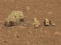
Interesting new shot from sol 27 http://mars.jpl.nasa.gov/msl/multimedia/raw/?rawid=0027MR0129005000E1_DXXX&s=27
Looks like all the small cobbles/gravel eroded out of another rock surface.
Posted by: climber Sep 11 2012, 03:52 PM
re-posted here from wrong topic:
It's remarkable how clean is (the downwind?) side of both rock and gravels. I don't recall such (big) difference in other landing sites.
Lot of gravels, BTW. Is that a sign of alluvial place or not at all?
Posted by: Skyrunner Sep 11 2012, 04:01 PM
One of the portion pokers? Mentioned here: http://www.planetary.org/blogs/guest-blogs/20120821-limonadi-sampling-mars-3-drilling-challenges.html and in the first part of that excellent series: http://www.planetary.org/blogs/guest-blogs/20120816-limonadi-sampling-mars-1-tools.html
Posted by: elakdawalla Sep 11 2012, 04:18 PM
Skyrunner, I would assume until proven otherwise that mcaplinger (who works at Malin Space Science Systems and has been involved in the design, build, and operation of several spectacular spacecraft cameras) knows what he's talking about in this case.
Posted by: mcaplinger Sep 11 2012, 04:27 PM
While I appreciate the sentiment, in this case I really don't know and skyrunner might well be right. I've never even been in the same room as MSL and I'm just speculating about what that thing is.
Posted by: dvandorn Sep 11 2012, 04:40 PM
Looks like all the small cobbles/gravel eroded out of another rock surface.
Looks like a breccia, a tuff with inclusions or even a conglomerate rock is being eroded away, here. At least, the part that sticks out above the surface is being eroded. In some areas the matrix and the clasts look to be the same hardness, and in others it appears that the matrix is softer and is eroding faster than the clasts, letting the clasts drop out as cobbles around the base of the rock.
Also looks like most of the clasts or inclusions are roughly spherical...
-the other Doug
Posted by: climber Sep 11 2012, 05:23 PM
|
|
I know, things are not comparable BUT...what a progress when one think at this picture:

|
Posted by: mcaplinger Sep 11 2012, 05:40 PM
I don't think so, based on the drawings those are both closer to the deck, larger, and outside the area covered by the belly pan. But I'm not positive.
Posted by: Floyd Sep 11 2012, 05:50 PM
The poker skyrunner refers to is a nail size object on the arm (as described in the writeup for the poker), the picture mcaplinger refers to is a wire on the body and does seem to fit the static discharge wire described in mcaplinger's reference. I would second static discharge as probable purpose of wire. Would be interesting to see if there are wires at the four corners of the WEB/body.
Posted by: Nix Sep 11 2012, 07:14 PM
I had some fun with this insane mosaic too... though it's a though one to make within reasonable time!
http://www.flickr.com/photos/87105932@N04/7977663581/in/photostream
Posted by: RoverDriver Sep 11 2012, 07:23 PM
I'm not so sure MAHLI would have been designed to be able to focus in such a wide range if we did not attempt this image (and the MTES shroud) on MER. still, the MAHLI camera is awesome. So awesome the images look CGI.
Paolo
Posted by: marsman2020 Sep 11 2012, 08:21 PM
Yes, that's the one of the discharge needles. There is one in each corner of the rover; the ones in the rear were a bit higher up but may be visible in some of the shots looking down the side of the rover towards the calibration target/sundial.
On the ATLO floor they were covered with some red covers to keep people from poking themselves. On MER there was a handmade sign was some....coarse language...that can numerously be seen in some of the IMAX shots.
On MER the discharge needles were simply bonded to the corners of the WEB; on MSL we gave them their own little bracket so they could be more easily changed if they did get bent somehow.
(Thanks for spotting another piece of hardware I was involved with. In between my lengthier tasks on MSL, I did a few other odds and ends and the needles were one of them)
Edit: If you look in the bottom-left of this image - http://mars.jpl.nasa.gov/msl-raw-images/msss/00024/mcam/0024ML0117000000E1_DXXX.jpg - you can see one of the discharge needles at the rear of the rover chassis as well.
Posted by: udolein Sep 11 2012, 09:43 PM
I'm wondering whether someone has already noticed this on Sol 32:
CHIMRA activities:

|
http://www.marspages.eu/media/archive4/science_laboratory/8calibrationphase2/Chimra2.gif

|
http://www.marspages.eu/media/archive4/science_laboratory/8calibrationphase2/Chimra.gif
Cheers, Udo
Posted by: bigdipper Sep 11 2012, 09:52 PM
I agree...and am looking forward to special wheel icons for MSL.
Posted by: neo56 Sep 11 2012, 10:45 PM
Well done Udo ! Here is an animation of CHIMRA activities from the Mastcam100 pictures. Nice to see part of this instrument in action !

|

|
Posted by: drz1111 Sep 11 2012, 11:19 PM
Also looks like most of the clasts or inclusions are roughly spherical...
-the other Doug
the rounded nature of the clasts in that rock is super exciting, IMO. Even if the rock as a whole ends up being a tuff of some sort . . . its very suggestive of water playing a role in the weathering of the clasts at some point in their history.
Posted by: eoincampbell Sep 11 2012, 11:26 PM
Is the portion poker not next to the sample playground & observation tray as in this shot from sol 14 :
http://mars.jpl.nasa.gov/msl/multimedia/raw/?rawid=NLA_398742309EDR_F0030004NCAM00121M_&s=14
?
Posted by: Doc Sep 11 2012, 11:30 PM
Teleconference scheduled for 1800 GMT.
BTW nice gifs udolein! Hadn't noticed those ones
Posted by: xflare Sep 12 2012, 12:02 AM
Looks exactly like unwashed river gravel to me.
Posted by: Don1 Sep 12 2012, 12:18 AM
There's supposed to be a lithified alluvial fan in this area, and I think that could be what we're seeing. The rock looks like a conglomerate, and the pebbles next to it look like the kind of smooth rounded rocks you see by a stream. There seems to be a light population and a dark population of pebbles., so it isn't all basalt. There is a light colored area nearby, so that might be the source of the light pebbles.
http://mars.jpl.nasa.gov/msl/multimedia/raw/?rawid=0027MR0129005000E1_DXXX&s=27
Edited to remove reference to titanium.
Posted by: Joffan Sep 12 2012, 05:59 AM
I'm wondering why we're seeing the "concrete" rock one-sidedly clean of dust, and also about that small fleck of bright clean rock on top of the dust, about central in the picture. Is it possible that on sol 27 we were still seeing some effects of the outer edge of the descent stage exhaust wash? Except we've moved off the main plumes...
Posted by: walfy Sep 12 2012, 06:22 AM
I'm guessing those rounded rocks are a very significant discovery. Nothing like river-worn gravel!
Posted by: dilo Sep 12 2012, 06:57 AM
About "calibration penny" target, I think this comparison between Earth pre-launch (rescaled) picture and Sol34 MAHLI image could be interesting, at least for evaluating how much dust on it...

|
Posted by: walfy Sep 12 2012, 07:11 AM
A very quickly made GIF:

|
Looks like another successful test!
Posted by: vikingmars Sep 12 2012, 07:33 AM
Dilo : Yes, you are right. It's dusty, but not so much when compared under same light conditions.
In the middle, I added your Martian MAHLI image, but seen under Earth light conditions.
Anyhow, the dust flows around the target are more obvious...

|
Posted by: dilo Sep 12 2012, 11:04 AM
Interesting, vikingmars! I guessed colorations differences due to different environment, where/how did you obtained the image under Earth light conditions?
Posted by: drz1111 Sep 12 2012, 12:18 PM
http://mars.jpl.nasa.gov/msl/multimedia/raw/?rawid=0027MR0129005000E1_DXXX&s=27
Edited to remove reference to titanium.
There are also quasi-volcanic possibilities; i.e., I've seen lithified lahars on earth that look just like fluvial conglomerates until you look up close at the matrix. But the rounded cobbles suggest transport and weathering, and I don't see how you do that without some kind of water-mediated process. If its a lahar or something like that, the rock could still be a record of catastrophic erosion, much like a breccia would be.
Posted by: Doc Sep 12 2012, 01:51 PM
White balance (though accuracy required is beyond me
)
Posted by: Doc Sep 12 2012, 01:53 PM
Thank goodness nothing shorted out!
Posted by: mcaplinger Sep 12 2012, 02:12 PM
I'm pretty sure that the image you have labeled "calibration" ( http://mars.jpl.nasa.gov/msl/images/PIA15284_MAHLI_and_APXS_CalTargets_Simmonds-br2.jpg ) was taken with a commercial camera using a flash. I'd be cautious drawing any conclusions from that.
I'd say the calibration target is pretty dirty. For example, the white and gray color chips are almost certainly useless for white balance now. Fortunately the rover has a lot of white thermal control paint which is comparatively clean.
Posted by: Paul Fjeld Sep 12 2012, 02:33 PM
Here's a flat image (full size!) of the calibration target:
http://www.nasa.gov/mission_pages/msl/multimedia/pia15286.html
What I find interesting is how dull the Kapton tape is. I think it is 1 mil thick, 1 inch wide tape and it is very dull and colorless compared to its amber and shiny appearance on earth. I would have thought that the pink/orangy/browny :-) environmental lighting would have punched up those colors. If so, shouldn't the landscape be much brighter in color than it's been portrayed in the processed images to date? The dullness of the tape makes it look like it was dusted by a fine talcum powder-like substance, but I don't see any affect like that on the white wire bundle ties. It's puzzling.
Posted by: vikingmars Sep 12 2012, 02:34 PM
Thanks Dilo : as Doc said a a "white balance" using an average of gray values (here sampled on the metallic housing pictured on Earth) to calibrate precisely the R-G-B values... an old technique, but a very efficient one I was taught at JPL and that was used to calibrate the colors at JPL-IPL on VL and MPF pictures (providing that the colors on Earth were taken with sun-like conditions of course...).
Posted by: Doc Sep 12 2012, 03:28 PM
Sol 36 MAHLI image showing a view looking into SAM's inlets
http://mars.jpl.nasa.gov/msl-raw-images/msss/00036/mhli/0036MH0051001000E1_DXXX.jpg
Is that gold I spy....?
Posted by: Doc Sep 12 2012, 03:31 PM
Sub frame image of the same view but haven't a clue why it's gray. Testing out the LEDs perhaps
http://mars.jpl.nasa.gov/msl-raw-images/msss/00036/mhli/0036MH0055000001S0_DXXX.jpg
Posted by: Doc Sep 12 2012, 03:57 PM
Did a rough stitch of sol 36 nav images. Note one of the still open SAM outlets at the time...

|
Posted by: mcaplinger Sep 12 2012, 04:16 PM
It's a derived depth map from the focus merge.
Posted by: fredk Sep 12 2012, 04:24 PM
Posted by: Doc Sep 12 2012, 04:54 PM
Oh yeah.... thanks mcaplinger
Posted by: neo56 Sep 12 2012, 06:30 PM
NASA teleconference: Mastcam will observe Phobos transiting the Sun today on sol 37. I'm looking forward the pictures !
Posted by: Doc Sep 12 2012, 06:43 PM
Was it today?
Posted by: jmknapp Sep 12 2012, 07:11 PM
Press conference just concluded. Just one more day of CAP activities. APXS is working marvelously and so is MAHLI (of course we can see that). The sun is due to rise in a couple of hours, sol 37 & mastcam will be capturing a transit of Phobos during the day--bring out the eclipse glasses.
Posted by: xflare Sep 12 2012, 08:12 PM
Left and Right MASTCAM images of the Sun here on SOL 33
http://mars.jpl.nasa.gov/msl/multimedia/raw/?rawid=0033ML0009005000D1_DXXX&s=33
http://mars.jpl.nasa.gov/msl/multimedia/raw/?rawid=0033MR0008004000D1_DXXX&s=33
Posted by: Doc Sep 12 2012, 08:53 PM
Eyes on the Solar System says the transit should be happening at the moment...
Posted by: paraisosdelsistemasolar Sep 12 2012, 08:58 PM
I did a simulation on Starry Night, I can't tell how accurate is it, but at least we have something to see until thumbnails come to Earth!

|
The animation is for the 5:15 UT transit on 13/09/2012.
Posted by: mcaplinger Sep 12 2012, 09:11 PM
http://meetingorganizer.copernicus.org/EPSC2012/EPSC2012-326.pdf says the transit is at 05:15 UT on 9/13, which is about 8 hours from now.
Posted by: Doc Sep 12 2012, 09:42 PM
Thanks for clarifying. Actually I tried using HORIZONS but Curiosity's landing site is not available as an observer option.
Anyone knows when it might be available?
Posted by: paraisosdelsistemasolar Sep 12 2012, 09:44 PM
Anyone knows when it might be available?
It seems that the next avaiable MRO pass starts at 5:45 UT.
Posted by: Deimos Sep 12 2012, 10:22 PM
I wish it looked like that animation! Oh well, there will be other days. And by the time they come, we'll know more about the timing of the flight system and about the performance of the video. At least the pass is shortly after the transit.
Posted by: jmknapp Sep 13 2012, 02:20 AM
This should should be about the relative sizes of things in the mastcam34 frame:

|
EDIT: correction: this is the mastcam100 view. The mastcam34 view will be about 3x smaller in the frame.
Posted by: Cargo Cult Sep 13 2012, 03:30 AM
I'd been messing around with renders of earthly LIDAR and Marsly HiRISE elevation maps recently - so immediately recognised it as a heightfield. Or rather, in this case it is indeed a depth map - inverting the intensity turns it back into something that works as a displacement map in Modo. (Note: I made a completely arbitrary guess at the displacement distance.)
Just a screenshot from the 3D view, offset at a bit of an angle:

|
Also, a quick attempt at an anaglyph view:

|
The elevation map is decidedly hazy, but already gives a dramatic sense of 3D-ness. I'd love to see what it does with lumpy, rocky stuff with lots more surface detail for the algorithms to work on!
Posted by: MarsEngineer Sep 13 2012, 03:46 AM
Mike is right. I asked (oops, "we". there is no "I" in MSL) that we add these "Paschen point" discharge needles after the 2009 slip in order to get the total charged potential of the rover+ descent stage (during EDL) down to a couple of a hundred volts. (with Geoff Landis' help we did on MER and Sojourner too). I did not want a large discharge to occur at touchdown. I was concerned about the digital link between the rover and the descent stage being adversely affected which would have corrupted the data prior to descent stage fly away which would have ... well you get the picture. That is also one reason I asked to change the digital design of the circuits that connected the rover to the descent stage in early 2009 (from LVDS to 1553). I am a big worry wort in this dept. Those (painfully sharp) needles should also prevent the rover from accumulating excess charge while driving around on .. what ... cemented cobbles??? (I will have to be patient with the rest of you all - I need to avoid scientific interpretation. I am no geologist, but I sure wish I was now and again.)
This is SOOO fun. I can't tell you what a great load has been lifted off of my shoulders (something like 900 kg). This has been harder than MER and MPF combined. That everything is working so much better than we ever had a right to expect is just really unbelievable to all of us. (Just the circuit noise challenges we had with testing APXS on Earth seem to have vanished now that Curiosity is happily on Mars. What? I would never have bet that the noise would so completely vanish after the rework of the APXS cables we did at the very last minute in Florida last summer. )
We just need one more thing to work well and that is drill/sample transfer (knock on wood). Once that works I will be in Mars engineering heaven.
-Rob Manning
MSL chief engineer
PS sorry about not posting here more often.
Posted by: MarsEngineer Sep 13 2012, 03:52 AM
You all are amazing. We are extraordinarily impressed with the work you all are doing.
A depth map of the inlet cover? The gifs of the CHIMRA doors? The corrected belly pans? the interpretations of the cemented structures? Phobos crossing image predicts? really, wow.
Keep it up. The MSL team is watching and learning from you (with healthy mars time lag).
-Rob
Posted by: Astro0 Sep 13 2012, 03:58 AM
That you post here at all Rob is amazing to us all!
Many thanks for your insights.
I was just speaking to someone this morning about how incredible it was, that in the minutes after landing, a member of the EDL team actually took the time to http://www.unmannedspaceflight.com/index.php?showtopic=7397&view=findpost&p=186844 during all the celebrations at JPL.
Eternally grateful to you and so many others on "the inside" for sharing with us.
There may be no "I" in MSL, but everyone of "us" on UMSF appreciate you.
Posted by: xflare Sep 13 2012, 08:31 AM
Sol 33 image, looking towards the Alluvial Fan, which I believe can be seen in the distance in the distance, winding down the crater wall.
http://mars.jpl.nasa.gov/msl-raw-images/msss/00033/mcam/0033MR0137004000E1_DXXX.jpg
Posted by: Nix Sep 13 2012, 09:53 AM
http://img59.imageshack.us/img59/6568/0034mh0061001000e1dxxxm.jpg
Had another go with the belly-pan. Because of some blurred frames, I tried to create an effect comparable to the shallow dof of let's say a 24mm f3.5 shot of Curiosity. I'd like to see
others go further and use Earth-based images of the front of Curiosity, add an artificial sky and horizon scenery from other raws, etc... so feel free to use for further manipulation
Nix
Posted by: paraisosdelsistemasolar Sep 13 2012, 09:53 AM
A quick and dirty panorama of Mastcam Sol 33 panorama (HINT: Click over "reduced" to see the full version, otherwise it will show the thumbnail).
http://www.ungeologoenapuros.es/panorma_33.jpg
|
|
Posted by: jmknapp Sep 13 2012, 11:53 AM
That is just wild! Looking forward to more of that.
Some level adjustments on a "swell" sol 25 image that just came down:

|
Posted by: drz1111 Sep 13 2012, 02:14 PM
http://mars.jpl.nasa.gov/msl-raw-images/msss/00033/mcam/0033MR0137004000E1_DXXX.jpg
The thing winding down the crater wall wouldn't be the alluvial fan. If it's fluvial, it would be an arroyo / dry bed / wadi. The fan would be the slope of sediment at the "mouth" of that channel.
Posted by: tolis Sep 13 2012, 02:29 PM
Any idea on whether the 34mm or the 100mm 'eye' will be used? it would appear larger in MastCam100.
Posted by: mcaplinger Sep 13 2012, 03:09 PM
I'm not sure how this was derived. The 34mm should look more or less like the MER image below, since this transit was grazing, and the 100mm will be 3x bigger.

Again, this is a MER image; I got it from http://pancam.astro.cornell.edu/pancam_instrument/projects_4.html And of course it's been blown up; the sun is about 15 pixels across in Pancam IIRC.
Posted by: Doc Sep 13 2012, 03:52 PM
Incredible work sir!
Posted by: markril Sep 13 2012, 04:55 PM
A likely culprit of what's dinging up those beautiful wheels. Notice how the treads were lifted off the ground as the rover rolled over it:

|
And, a stereo pair of the scene:

|
Mark
Posted by: Deimos Sep 13 2012, 05:39 PM
What is this "or" you speak of?
Posted by: jmknapp Sep 13 2012, 05:40 PM
I was just showing the relative sizes of the Sun and Phobos in the frame, not their relative positions--I tried getting their positions using the SPICE kernels but for some reason I was getting a near miss rather than a transit.
BTW, I should have said the image was for mastcam100, not mastcam34. Here's the calculation: According to the mastcam100 ftp://naif.jpl.nasa.gov/pub/naif/MSL/kernels/ik/msl_mr_20120731_c03.ti, the resolution is about 0.00426 deg/pixel. So the whole 1648x1200 frame is about 7.0°x5.1°. At the time of the transit, Phobos is 5916 km from MSL (per SPICE) and the Sun is 222,493,508 km. Using a Sun diameter of 1.38e6 km and Phobos diameter of 11.1 km gives an angular size for the Sun of 0.354° and for Phobos 0.107°. That works out to 83 pixels diameter for the Sun and 25 for Phobos.
Posted by: Stu Sep 13 2012, 07:11 PM
Lots of lovely Bayer-crud-free colour images posted today, here's a quick mosaic of them...
http://galegazette.files.wordpress.com/2012/09/pan-sept-13.jpg
Posted by: dvandorn Sep 13 2012, 07:29 PM
Hmmm... there are now several Mastcam images at the raw image site, taken on Sol 36 between 06:30:17 and 06:35:19 UTC, that show a pretty blank scene. The first 10 images are grayscale, the next 10 images are all blue-filtered, and the final 10 images look to be the natural color of the sky.
Could they have possibly targeted the Sun for the Phobos transit and the pointing was slightly off? Timing doesn't seem right, though.
-the other Doug
Posted by: ugordan Sep 13 2012, 07:45 PM
Methinks they wouldn't point the camera at the Sun without the neutral density filter in place.
Would Phobos be visible in the daytime sky when it's several tens of degrees away from the Sun?
Posted by: fredk Sep 13 2012, 07:51 PM
Edit: Perhaps well away from the sun in the winter, when tau is low. Dusty summer skies would be hard. I don't recall daytime Phobos imaging from MER...
Posted by: elakdawalla Sep 13 2012, 09:35 PM
https://twitter.com/Matt_Heverly/status/246296771427450881 earlier today that they're "on the road again," planning the seventh drive. So sol 38 will be a driving day, and it's time to start a http://www.unmannedspaceflight.com/index.php?showtopic=7471!
Posted by: Ant103 Sep 14 2012, 12:32 AM
Sol 33 Mastcam100 panoramic. There's some rover's tracks there
http://www.db-prods.net/marsroversimages/curiosity.html#sol33
Posted by: xflare Sep 14 2012, 09:44 AM
SOL 36 Mastcam100 pan

|
Posted by: belleraphon1 Sep 14 2012, 01:11 PM
Sol 37 - 688 new images down
One full frame MASTCAM and a slew of thumbnails down that look like the Sun/Phobos transit capture attempt. Cannot make anything out in the thumbnails.
http://mars.jpl.nasa.gov/msl-raw-images/msss/00037/mcam/0037MR0099010000D1_DXXX.jpg
Craig
Posted by: jmknapp Sep 14 2012, 02:00 PM
Me neither. Looks like they shot it at about 3 frames per second. There's one full frame shot available so far, taken at the beginning of the sequence:
http://mars.jpl.nasa.gov/msl-raw-images/msss/00037/mcam/0037MR0099010000D1_DXXX.jpg
So that shows what the full frames will look like anyway.
Posted by: verfkwast Sep 14 2012, 04:16 PM
No its not the normal origins story but when seeing
your Mount panorama & looking around in the Crater with the
http://www.marsmap.valkvideos.nl/ to me it looks like Gale is not
made bij water/mud filling but by lava/water mixing.
Looking at Mount S. i think to see the layering & 3 old calderas from
an central Sheeld Vulcano with big lava (& water) flows
Some examples (starting north, anti clockwise)
|
Posted by: paraisosdelsistemasolar Sep 14 2012, 05:00 PM
I clearly can see water related processes, sedimentation and niveo-aeolian deposition, but no sign of volcanic activity.
Posted by: centsworth_II Sep 14 2012, 05:41 PM
Posted by: Ant103 Sep 14 2012, 05:55 PM
Sol 36 Mastcam 100 mosaic :
http://www.db-prods.net/marsroversimages/curiosity.html#sol36
Posted by: jmknapp Sep 14 2012, 07:06 PM
Still, it's good to keep in mind the old skeptic quip: "I wouldn't have seen it if I hadn't believed it."
Posted by: Oersted Sep 14 2012, 08:00 PM
Thanks for the cross-eye, Mark: much appreciated, I like it!
Posted by: Cruzeiro do Sul Sep 14 2012, 09:31 PM
Sorry if somebody have already spoke about this here, but i saw in mastcam images from sol 33 this:http://mars.jpl.nasa.gov/msl-raw-images/msss/00033/mcam/0033ML0008005000I1_DXXX-br.jpg
It reminds me an image taken by Opportunity, i thought, severals ago. Is this little blue dot be Earth...or most simply one of Mars Moons? Thanks for your attention.
Posted by: fredk Sep 14 2012, 09:51 PM
That's from the sequence of sun images we've been discussing. I think it's much too early to be thinking about nighttime imaging.
Posted by: Cruzeiro do Sul Sep 14 2012, 10:09 PM
ok. Thanks to clear this point. To early for that yes, but it will be a very interesting image for sure!
Posted by: belleraphon1 Sep 14 2012, 10:37 PM
Agree... personnaly I do not see volcanics but then I am no geologist. Remember we went to Gusev thinking it was an ancient lake bed. Landing site turned out be basaltic rock.
We all need to keep open minds. The rocks will tell in us time. We have just started listening.
Craig
Posted by: dvandorn Sep 14 2012, 11:01 PM
So far, from what I've heard, ChemCam is seeing mostly basaltic rock here, too. A vast majority of the surface of Mars is basaltic rock, I think -- heck, even the evaporites at Meridiani seem to be basaltic fine-grained sand particles cemented primarily by sulfur salts.
The problem with Martian surface geology is that, in many locations, the rocks have been transported to where they lie on the surface from elsewhere. Even laid-down beds of rock strata (like the various layers identified on the floor of Gale) were likely made up of fines and rocks transported in from elsewhere and then laid down in beds by depositional or sedimentary processes. I mean, c'mon -- what makes up an alluvial fan? The fines and pebbles that were washed into the location by moving water. Yes, they were emplaced alluvially, and may have been modified in the process of deposition, but ultimately the rocks and fines were originally erupted onto the surface, or laid down sedimentarily, somewhere else on Mars and have been transported to where they lie now.
-the other Doug
Posted by: paraisosdelsistemasolar Sep 15 2012, 08:33 AM
Two of the Fobos transit images are finally here
First, the left MastCam image:

|
Second, the right MastCam image:

|
I had a lot of problems on debayering right MastCam, so that's my best shot at the moment.
Posted by: Actionman Sep 15 2012, 01:20 PM
It seems to me that this is an interesting rock because if it is indigenous and it is what it looks like it could be, a geode, and then that would go a pretty good way to describing the evolution of the planet Mars, maybe.
http://mars.jpl.nasa.gov/msl-raw-images/msss/00036/mcam/0036MR0148001000E1_DXXX.jpg

|
Posted by: drz1111 Sep 15 2012, 02:52 PM
OK. There's still no evidence of a shield volcano, and eyeballing landforms is about the crudest form of "geology" there is.
Volcanics and water-mediated sedimentary processes are not mutually exclusive. Lahars, ashfalls into standing water, etc. The question of "did water play a role in deposition" is a separate and mostly independent one from "is this volcanic derived"? And the line can get blurry - is an arkose conglomerate derived from nearby volcanics purely sedimentary (conventional categorization would say "yes", but it's 90% of the way there, not 100%).
Posted by: fredk Sep 15 2012, 03:56 PM
My FFT Fourier filtering is also having serious trouble with the solar shot. One of the other techniques used here will probably work better. Here's my best (quick and dirty) shot, using Fourier filtering at 2, 4, and 8 pixel periods, followed by 2px Gaussian blur. No deBayering at all, since the image uses a monochromatic filter anyway.

|
You can easily see the asymmetric profile (which you could with MER pancam too).
ADMIN NOTE: A bunch of posts that followed this one, discussing image compression etc, were moved to the http://www.unmannedspaceflight.com/index.php?showtopic=7418&view=findpost&p=191470 thread.
Posted by: EdTruthan Sep 15 2012, 06:10 PM
White balanced & level adjusted mosaic of the 12 new MC100 frames from Sol 36. Really nice detail on the slopes of Mt. Sharp in this light....
http://www.edtruthan.com/mars/Sol36-MC100-North-Flank-Mt.Sharp.jpg
...and for anaglyph lovers (like myself!) who relish in gleaning every bit of z-axis eye candy from the landscape here's an anaglyph of the same using Bradbury Landing (MC34 unfortunately) as the left eye baseline differential (which due to the angle of travel is slight, but enough for some noticable depth):
http://www.edtruthan.com/mars/Sol-36-MC100-North-Flank-Mt.Sharp-Anaglyph.jpg
Posted by: fredk Sep 15 2012, 08:11 PM
This is interesting because we've been driving more or less towards the right side of this mosaic, so the stereo effect disappears there.
This reminds me: looking at the latest route maps, you can see that we've been headed quite a bit south of Glenelg. These first drives form a nicely oriented baseline for stereo imaging of the potential approach to the clays/base of the mound. My guess is we're not headed straight towards Glenelg for that reason. We've seen similar with MER, and Malin mentioned long baseline stereo at the early press conferences.
Posted by: stewjack Sep 15 2012, 09:03 PM
I'm not a geologist, but I think it's an interesting catch. Wish we had a Left image. I also wish the rock had a name. If it had a name then we wouldn't have to say; "Hey I think there is a very interesting rock in image 0036MR0148001000E1_DXXX.jpg." Since we already passed it by perhaps we will see another one.
Anyway here is a reference link in case we do see something similar.
http://mars.jpl.nasa.gov/msl-raw-images/msss/00036/mcam/0036MR0148001000E1_DXXX.jpg
Posted by: MarsInMyLifetime Sep 15 2012, 09:35 PM
http://www.edtruthan.com/mars/Sol36-MC100-North-Flank-Mt.Sharp.jpg
On this high-resolution product, the second image segment from the left is looking in the direction of the heat shield's resting place. The flattish dark object more to the right of this segment, below the dunes, is a good candidate for the heat shield, and the resolution is clear enough that I seem to see the turned up, rounded rim arching over the darker material. Will the remaining track to Glenelg put Curiosity in any better viewing vantage for this EDL article?
Posted by: EdTruthan Sep 15 2012, 11:32 PM
I noticed that too, but I've replied in the "MSL EDL Hardware" thread http://www.unmannedspaceflight.com/index.php?s=&showtopic=7401&view=findpost&p=191502 (with graphic) to keep this thread clean of HS discussions.
Posted by: jmknapp Sep 16 2012, 01:13 AM
Did you see the news story re Mars/water going around a few days ago? Here's the BBC take:
http://www.bbc.co.uk/news/science-environment-19525421
Which explains maybe why water has to be continually "discovered" on Mars. There's water, and then there's water.
Posted by: jmknapp Sep 16 2012, 01:17 AM
Who's to say the science team can't revisit these sites once they are firmly in the driver's seat?
Posted by: pac56 Sep 16 2012, 02:05 AM
How much multitasking is MSL capable? For example, what science activities can be done while roving, if any. Does driving eat all of the energy budget?
Posted by: stewjack Sep 16 2012, 02:21 AM
Well I if we traveled a long distance to return to the rock, and then discoved that the other side of the rock made it much less interesting,
please don't say that I ever thought that rock was interesting! Not me! No way! It's all jmknapp's fault
Posted by: jmknapp Sep 17 2012, 01:24 AM
Well, then I fall back on "I'm an engineer, not a scientist, dammit!" Just musing on what they can do if they want, particularly since they haven't gone all that far yet..
Posted by: paraisosdelsistemasolar Sep 17 2012, 01:56 PM
With the downloaded Left MastCam frames I did an animation to see how it looked just for preview purposes... while we wait for the full set of frames

|
Posted by: fredk Sep 17 2012, 03:42 PM
This post doesn't fit into any thread perfectly - long baseline stereo from sols 19 and 37. This is using M100 with a good baseline. It gives a taste of what's to come when we get M100 coverage of the main butte/mesa area from a new position...
Here's a greyscale anaglyph:

|
And colour side-by-side:

|
Posted by: elakdawalla Sep 17 2012, 04:23 PM
Wow, that one is seriously brain-bending. Regarding the thread, you've got it in the right place; when an image includes data from many dates, the date I use for bookkeeping / temporal sorting of blog posts and pictures is the most recent data acquisition date.
Posted by: Ant103 Sep 17 2012, 04:39 PM
Drive direction Mastcam34 pan :
http://www.db-prods.net/marsroversimages/Curiosity/2012/Sol41_Mastcam34.jpg
Posted by: EdTruthan Sep 17 2012, 04:54 PM
Very Nice FredK. I'm sure you've noticed as I did that your anaglyph comprises one of the few good overlapping MC100's of the Mt. Sharp flanks for hi-res anaglyphs so far. (Grrrr...). None the less, using the MC34 + MC100 technique we've tried a few times, the full breadth of the 4 new Sol 37 MC100 pictures still makes a killer z-axis treat. Here's the 2D and 3D versions:
Default color:
http://www.edtruthan.com/mars/Sol37-Mt.Sharp-Flanks-Full.jpg
Enhanced:
http://www.edtruthan.com/mars/Sol37-Mt.Sharp-Flanks-Enhanced-Full.jpg
And my favorite, an anaglyph:
http://www.edtruthan.com/mars/Sol37-Mt.Sharp-Flanks-Anaglyph-Full.jpg
Yum, yum, yum....
Posted by: udolein Sep 17 2012, 07:57 PM
Phobos-Sun encounter at Sep 13, 2012 on Sol 37:

|
http://www.marspages.eu/media/archive4/science_laboratory/9glenelgdrivecontinuation/Sol37_Phobos.gif
Regards, Udo
Posted by: udolein Sep 18 2012, 12:32 PM
My version of the Sol 37 CAP2 scenery in a more earthlike style

|
simply breathtaking ...
Cheers, Udo
Posted by: fredk Sep 19 2012, 07:05 PM
Emily, it looks to me like a sunspot in the M100 sequence, see arrow:

|
At least it appears to be at the same position relative to the sun in all the frames, while the sun drifts from frame to frame, so it doesn't look like a bad pixel or whatever. However, it fluctuates quite a bit in visibility, even disappearing in frame 2, but that could simply be due to noise.
Edit: perhaps we could confirm this with earth-based imagery, taking into account that we're seeing the sun from about 90 degrees different longitude between Earth and Mars.
Posted by: maschnitz Sep 19 2012, 07:15 PM
Stereo B has a good view, roughly where Mars is in its orbit (if I read the various diagrams correctly). Perhaps you can find the time of observation in Stereo B's archives.
http://stereo-ssc.nascom.nasa.gov/where.shtml
http://stereo.gsfc.nasa.gov/beacon/
Posted by: elakdawalla Sep 19 2012, 07:30 PM
Fredk, I saw that too; it's what prompted me to ask the question.
Maschnitz, you're right, Stereo B's view is more similar to Mars' than the view from Earth (roughly 30 degrees difference?)
http://space.jpl.nasa.gov/cgi-bin/wspace?tbody=1000&vbody=1001&month=9&day=13&year=2012&hour=00&minute=00&fovmul=1&rfov=5&bfov=30&porbs=1&showsc=1&showac=1
http://stereo.gsfc.nasa.gov/browse//2012/09/13/behind/euvi/195/1024/20120913_051030_n4euB_195.jpg (the eclipse began at 5:15 but there's a few more minutes light time from STEREO B to Mars, not that it matters)
To account for the ~30 deg difference we might look at http://stereo.gsfc.nasa.gov/browse//2012/09/11/behind/euvi/195/1024/20120911_051030_n4euB_195.jpg (Sun rotates once in 26 days at equator)
Because Curiosity's at the equator we need to rotate the STEREO view of the sun by 90 degrees, right? Which way, counterclockwise or clockwise?
Posted by: fredk Sep 19 2012, 08:44 PM
Where the sun's north pole is on the M100 view will depend on the azimuth of the sun, ie the local solar time, since mastcam sits on an altazimuth mount. Shouldn't be hard to work that out...
Once all the M100 frames are down, you could do a proper super-res to hopefully confirm this spot and see if anything else is visible. Usually when they do super-res with Oppy, they have to change the pointing slightly from frame to frame. But with the sun you can keep the pointing fixed and let the diurnal movement do the trick.
Posted by: Deimos Sep 20 2012, 01:26 AM
My eyes went to that spot as soon as I heard the question. It kind of aligns, but I am unconvinced since I wouldn't have picked the area as the best spot. The sol 42 images should be pretty definitive, if even that one is real.
Posted by: Ant103 Sep 21 2012, 10:49 AM
Sol 36 Mastcam100. Long picture is loooooooooooong.
http://www.db-prods.net/marsroversimages/curiosity.html#sol36
As said in http://www.unmannedspaceflight.com/index.php?s=&showtopic=7426&view=findpost&p=191825, this is overlaping the right part of Mount Sharp, so, we should get a 50 000 pixels wide panorama ! This is yet very tempting. Hey little Macbook, can you please do me a favour :3 ?
Posted by: maschnitz Sep 21 2012, 07:01 PM
Some notes on the sunspot Stereo B idea: I was trying to develop a basic intuition of the geometry, so I dove into Eyes (thanks, Doug! great program). I got a couple of screenshots at the time of the eclipse.
The Sun and Phobos are where the lines intersect in the second shot. The eclipse occurred in the afternoon, with the Sun in the west on Mars, over the Gale Crater rim. Stereo B was high in the sky to the west at the time, above the Sun.
Whether you turn the Stereo B images clockwise or counterclockwise depends on whether published Stereo B images are oriented with the solar north pole up, or down, respectively. (Assuming Martian north is the same as solar north, of course.) It's probably clockwise, since the Stereo team seem to pay strict attention to latitudes in their release image. Or you can turn the MastCam images counterclockwise (that is, this would mean solar north is to the right in the eclipse shots).
You can apply all this this way to any transit event. What you're really doing is figuring out where the solar north pole is. In fact, you won't turn MastCam images exactly 90 degrees CCW, you'll turn them so the solar north pole is straight up. That'll apply equally well at other times of day on Mars. I'm not sure how best to do that, though.
Side note: EPOXI was in an even better position. But naturally, they weren't making solar observations at the time.
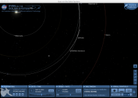
|
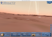
|
Posted by: MaG Sep 21 2012, 09:09 PM
Maybe it's not so hard, when you take a look at situation in "Eyes". Mars is now about 90 deg behind Earth, so what is about 90 deg left on the Sun from middle part visible from Earth, that is something what is on Mars in the middle. In last days I have read some info abou CME's from farside of the Sun. When you take a look on images from Stereo B, there is one very active region and also many of complicated magnetic fields. So maybe we will see in next days...
Here is one of the best Stereo B images of this part of the Sun with eruption..

|
ADMIN: Inline image replaced. Plesae note http://www.unmannedspaceflight.com/index.php?act=boardrules 3.2 and 3.3
Posted by: Pertinax Sep 22 2012, 06:06 PM
I've been tinkering with sunspot visibility 'climatology' for MC100, though not sure how best to summarize the data; how to make it the most meaningful. In the meantime, it hit me that a sunspot that was just resolvable (1 pixel) on mars by MSL's MC100 might well be rather comparable to a sunspot that was at the limit of unaided human vision on earth.
To check that idea I assumed the following:
MC100 (sun from Mars): about 0.00426 deg/pixel
Human Eye (sun from earth): about 0.00550 deg/pixel (http://clarkvision.com/imagedetail/eye-resolution.html)
Angular diameter of sun from earth: 0.536 deg (avg)
Angular diameter of sun from mars: 0.354 deg (avg)
angular size of a sunspot visible from mars that would be just visible to a human on earth: (0.354/0.536)*0.00550 = 0.00363 deg
Thus, a sunspot that is at the threshold of vision to a human on earth is ~= to one pixel on MSL's MC100 (0.004 deg = 0.004 deg)
That seem reasonable? I didn't notice any issues but I also have a fussing baby in background so my focus at the moment isn't 100%
Anyway, I though that was pretty neat (assuming I didn't make any mistakes) -- [also, Sunpot 1575 is just at the edge of visibility through welding glass currently]
-- Pertinax
Posted by: udolein Sep 22 2012, 06:36 PM
Here is my take on the Sol 42 Phobos transit.
Seems to see real stars in the background regardless of the poor signal to noise of the real transit:

|
http://www.marspages.eu/media/archive4/science_laboratory/8calibrationphase2/Sol42_Phobostransit.gif
Comparison with Eyes on the Solar System:

|
http://www.marspages.eu/media/archive4/science_laboratory/8calibrationphase2/PhobosTransit_Eyes.jpg
The bright objects above the sun are Jupiter and a background star ....
Cheers, Udo
Posted by: udolein Sep 22 2012, 06:46 PM
My take on the Sol 42 Deimos transit indicates that there is really a sunspot visible, especially in the enlarged version:
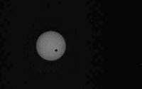
|
http://www.marspages.eu/media/archive4/science_laboratory/8calibrationphase2/Sol42_Deimostransit.gif
Regards, Udo
Posted by: fredk Sep 22 2012, 07:07 PM
Any star or planet would be many orders of magnitude fainter than the sun, so you'd never see them in the same image. Those bright spots are probably hot pixels on the CCD.
Posted by: Joffan Sep 22 2012, 08:25 PM
Yes, everything except Phobos would stay in step with the Sun if they were really stars or planets - and they don't.
Posted by: udolein Sep 23 2012, 09:05 AM
Yes, convincing. Seems that I'm wrong. But nevertheless an impressive coincidence between theory and non-observed reality ...
Regards, Udo
Posted by: Deimos Sep 23 2012, 12:44 PM
The coincidence gets better--on sol 37, during the Phobos grazing event, Deimos was geometrically within the M34 field of view. (...according to Starry Night--I didn't do detailed ephemeris for that.) Somewhere else in Gale crater, there might well have been a Deimos transit followed 20 minutes later by a Phobos annular eclipse.
Posted by: Nix Sep 24 2012, 08:08 AM
-IMG-
As said in http://www.unmannedspaceflight.com/index.php?s=&showtopic=7426&view=findpost&p=191825, this is overlaping the right part of Mount Sharp, so, we should get a 50 000 pixels wide panorama ! This is yet very tempting. Hey little Macbook, can you please do me a favour :3 ?
The number of pixels is indeed growing
The following image is a merge I've been working on but I haven't figured out what sol(s) I'm going to use for an anaglyph.
I'm waiting eagerly for the sol 42&45 full images to complete and optimize. (to avoid using left camera images) Then see if my pc isn't going to choke on this...
http://imageshack.us/photo/my-images/696/sharpsol03193637temp.jpg
and a preview of the big picture;
http://imageshack.us/photo/my-images/42/mountsharpmsltemp.jpg/
Powered by Invision Power Board (http://www.invisionboard.com)
© Invision Power Services (http://www.invisionpower.com)