Home Plate Etc., identifying features below Husband Hill |

  |
Home Plate Etc., identifying features below Husband Hill |
 Jul 23 2005, 01:20 PM Jul 23 2005, 01:20 PM
Post
#1
|
||
|
Solar System Cartographer  Group: Members Posts: 10164 Joined: 5-April 05 From: Canada Member No.: 227 |
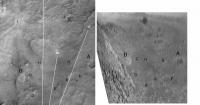
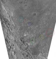
I thought this subject might deserve its own topic. John-s made several matches between features seen in Spirit images south of Husband Hill. Then I suggested that a specific feature seen in those pans (I provide an approximately reprojected map-geometry version of the pan) might be Home Plate:
Object B is what i think is Home Plate. The flanks but not the summit of Ramon Hill appear beyond it. There might be some errors in my attempted matches, but many seem good to me. It's quite hard to reconcile panoramic and overhead topography in this way, even towards Bonneville. I would really welcome any other attempts to match features like this, to see if we can resolve the question... if B in the pan is not Home Plate, what is it? Phil -------------------- ... because the Solar System ain't gonna map itself.
Also to be found posting similar content on https://mastodon.social/@PhilStooke Maps for download (free PD: https://upload.wikimedia.org/wikipedia/comm...Cartography.pdf NOTE: everything created by me which I post on UMSF is considered to be in the public domain (NOT CC, public domain) |
|
 |
 
|
|
|
Jul 23 2005, 04:33 PM
Post
#2
|
||
|
Solar System Cartographer Group: Members Posts: 10164 Joined: 5-April 05 From: Canada Member No.: 227 |
This is an alternate attempt to match features. B (here called B2) and C don't look as good to me. C especially, I really don't know what it's supposed to be. But it would work better for people who don't think we can see quite as far east as Home Plate yet. In the original it was B and C together which first intrigued me.
You can see how many uncertainties there are in this type of work. And it's amazingly easy to fool yourself into being certain about a very fuzzy match. Despite the air of certainty around Mike Malin's press release about Viking 2 earlier this year, the same uncertainties still surround that identification. Phil
-------------------- ... because the Solar System ain't gonna map itself.
Also to be found posting similar content on https://mastodon.social/@PhilStooke Maps for download (free PD: https://upload.wikimedia.org/wikipedia/comm...Cartography.pdf NOTE: everything created by me which I post on UMSF is considered to be in the public domain (NOT CC, public domain) |
|
|
|
|
|
|
Jul 23 2005, 05:11 PM
Post
#3
|
|
 Chief Assistant Group: Admin Posts: 1409 Joined: 5-January 05 From: Ierapetra, Greece Member No.: 136 |
Nice work Phil. I think your first match is right-on..
Nico -------------------- photographer, space imagery enthusiast, proud father and partner, and geek.
http://500px.com/sacred-photons & |
|
|
|
|
Jul 23 2005, 05:11 PM
Post
#4
|
||
|
Member Group: Members Posts: 236 Joined: 21-June 05 Member No.: 417 |
Here's my interpretation of "B":
Attached thumbnail(s)
|
|
|
|
|
|
|
Jul 23 2005, 05:30 PM
Post
#5
|
|
|
Solar System Cartographer Group: Members Posts: 10164 Joined: 5-April 05 From: Canada Member No.: 227 |
General - I see an object roughly the size and shape of Home Plate in your 'Feature B' - in the lower right (southeast) part of it in your image, that corresponds to my B2 in my second match. Could be...
What about the features around my 'I', on the slope of the hill? Phil -------------------- ... because the Solar System ain't gonna map itself.
Also to be found posting similar content on https://mastodon.social/@PhilStooke Maps for download (free PD: https://upload.wikimedia.org/wikipedia/comm...Cartography.pdf NOTE: everything created by me which I post on UMSF is considered to be in the public domain (NOT CC, public domain) |
|
|
|
|
Jul 23 2005, 05:54 PM
Post
#6
|
||
|
Member Group: Members Posts: 236 Joined: 21-June 05 Member No.: 417 |
Feature "I" - as I see it:
Attached thumbnail(s)
|
|
|
|
|
|
|
Jul 24 2005, 12:00 AM
Post
#7
|
|||
 Senior Member Group: Members Posts: 4247 Joined: 17-January 05 Member No.: 152 |
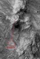
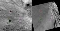
Phil, here's my take on this. Thanks for getting me started!
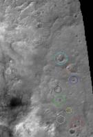
 Identified features are indicated with the same colour on my two images (one borrowed from you). I started with the famous "RU" dune pattern. It's interesting that we are only just starting to see the largest of the dunes down there (white arrow). Then I moved farther out. Red, yellow, green, black, and blue features I'm very confident of. (The bigger crater NE of the red pair is visible in other rover imagery). Orange, cyan, and grey I'm less confident of (I thought perhaps cyan should instead be grey on swplains.jpg). Regardless, we still have a ways to go to see homeplate. Also, homeplate is closer than the feature you initially ID'd, so, especially with pancam, the view should blow us away, if a dustdevil doesn't first!  Fred.
Attached thumbnail(s)
|
||
|
|
|
||
|
Jul 24 2005, 01:58 AM
Post
#8
|
|||
 Senior Member Group: Members Posts: 2492 Joined: 15-January 05 From: center Italy Member No.: 150 |
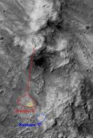
I substantially agree with fredk identifications.
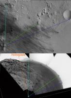
In fact, in the above image I used Sol 551 partial NavCam panorama and using PovRay I made a new vertical projection (right side); then on the left compared with MGS image (R1303051.R1301467.25) with same scale of 4m/pixel (assuming that now Spirit lies 70m above the plain mean level). There are many recognizable features in the two frames (colored circles); relative positions aren't perfectly respected probably due to slight quote differences, but anyway is clear enough that area highlighted by Phil (purple rectangle) is the far, "fluvial" structure, close to a long linear feature. Similar conclusions can be reached also by purely angular considerations:
Homeplate should lie closer (about 800m toward NE) but still hidden by hill; prepare to see it soon!  
-------------------- I always think before posting! - Marco -
|
||
|
|
|
||
|
Jul 24 2005, 03:45 AM
Post
#9
|
|
|
Solar System Cartographer Group: Members Posts: 10164 Joined: 5-April 05 From: Canada Member No.: 227 |
This has been very interesting. First let me say I am now convinced I was wrong, Home plate is not visible. I was jumping to conclusions too quickly. I was too obsessed by the features I called B and C - which do bear a superficial resemblance to Home Plate and a nearby marking.
But isn't this an interesting thing to play with? And I think there will be many opportunities to do this from the summit area - in all directions, I hope. In fact there should be things we can already do with images from past sols, looking to the northwest and even in a small area to the northeast, between the hills. Thank you all for participating in this. Phil -------------------- ... because the Solar System ain't gonna map itself.
Also to be found posting similar content on https://mastodon.social/@PhilStooke Maps for download (free PD: https://upload.wikimedia.org/wikipedia/comm...Cartography.pdf NOTE: everything created by me which I post on UMSF is considered to be in the public domain (NOT CC, public domain) |
|
|
|
|
Jul 24 2005, 07:14 AM
Post
#10
|
|
|
Member Group: Members Posts: 236 Joined: 21-June 05 Member No.: 417 |
I think the scientists at JPL will not know where to look first, once Spirit has reached the summit, such is the wealth of interesting and intriguing features in the Inner Basin. One big question remains: will Spirit be able to reach those features?
|
|
|
|
|
Jul 24 2005, 07:31 AM
Post
#11
|
|
|
Member Group: Members Posts: 233 Joined: 21-April 05 Member No.: 328 |
And will Spirit ever be able to spot its lander? At any rate, I hope they take the time for some nice tourist-type photos when they do get to the top. Glenn
|
|
|
|
|
Jul 24 2005, 08:08 AM
Post
#12
|
|
|
Senior Member Group: Members Posts: 1870 Joined: 20-February 05 Member No.: 174 |
Home plate will be visible with the west end of the mountain to the south towering above it. If Spirit treks east along the hilltop ridge to get views to the northeast into the bowl east of the one Larry's overlook looked into, and a view to the south into the inner basin, Home Plate might be between Spirit and the west flank of the south mountain. But any view from the west part of the hilltop ridge will have massive topography beyond home plate.
|
|
|
|
|
Jul 24 2005, 04:30 PM
Post
#13
|
||
|
Senior Member Group: Members Posts: 4247 Joined: 17-January 05 Member No.: 152 |
Beautiful projections, dilo! Someday I'll get back into POV...
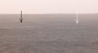
Glennwsmith, I think it'll be very hard to see the lander again. However, the heatshield is still visible on the rim of Bonneville. If the angles are right, the reflective heatshield catches glints of sunlight. The backshell/parachute should be much easier to spot than the lander, but even the parachute's ID is questionable in the images. See the pinned "spirit route map" thread starting with this post. Actually, after that thread, spirit caught the heatshield even more clearly on sol 538 (Independance pan). My attached image (thanks to Horton for the colour composite) shows it (white arrow) on the rim of Bonneville. This identification agrees with Alan's in the route map thread. I tentatively ID'd the parachute with the black arrow, although this does not exactly match Alan's ID in the older images. Interestingly, the blue and red spots near the horizon are a dustdevil passing some distance behind the lander/heatshield!
Attached thumbnail(s)
|
|
|
|
|
|
|
Jul 24 2005, 06:15 PM
Post
#14
|
|
|
Member Group: Members Posts: 233 Joined: 21-April 05 Member No.: 328 |
Fredk, re image of Bonneville and heashield: cool! It's amazing how far that little Spirit has traveled. Glenn
|
|
|
|
|
Jul 24 2005, 07:05 PM
Post
#15
|
|
|
Senior Member Group: Members Posts: 4247 Joined: 17-January 05 Member No.: 152 |
Another thought occurs to me: Dilo's projection should involve just one parameter: the height of spirit above "the plain". So it should be possible to constrain the height by adjusting that parameter until the feature positions agree with the orbital imagery (perhaps this is what you did, dilo).
But in reality, the "plain" will have some tilt and curvature. In principle, we should be able to recover this info from a single good-quality pan. I see it working this way: assume first the plains are truly flat. Adjust the rover height parameter to obtain the "best fit" between reliably identified features in pan and orbital images. Some of those features will be too low, and some too high, due to departures from flatness. Then simply adjust the height of each feature individually, up or down, and reproject, until the match is exact between the pan and orbital imagery. This gives us a set of points with well-determined elevations, which could be used to construct an elevation contour plot or whatever. Really, what this amounts to is an extreme form of stereo imaging: one view from the rover in the hills, the other view from orbit! In fact, it should be simple to construct visual analglyphs along these lines. Clearly this would be limited by how precisely we could identify features. Sounds like a project for a summer student! |
|
|
|
|

|
Lo-Fi Version | Time is now: 22nd May 2024 - 05:40 PM |
|
RULES AND GUIDELINES Please read the Forum Rules and Guidelines before posting. IMAGE COPYRIGHT |
OPINIONS AND MODERATION Opinions expressed on UnmannedSpaceflight.com are those of the individual posters and do not necessarily reflect the opinions of UnmannedSpaceflight.com or The Planetary Society. The all-volunteer UnmannedSpaceflight.com moderation team is wholly independent of The Planetary Society. The Planetary Society has no influence over decisions made by the UnmannedSpaceflight.com moderators. |
SUPPORT THE FORUM Unmannedspaceflight.com is funded by the Planetary Society. Please consider supporting our work and many other projects by donating to the Society or becoming a member. |
|