Tianwen-1- Development, China's 2020 Mission |

  |
Tianwen-1- Development, China's 2020 Mission |
 Jul 24 2020, 06:32 PM Jul 24 2020, 06:32 PM
Post
#46
|
|
 Member  Group: Members Posts: 226 Joined: 13-October 09 From: Olympus Mons Member No.: 4972 |
QUOTE (nogal @ Jul 24 2020, 12:14 PM)  Searching Alan Boyle's twitter posts I chanced upon a post by Thomas Schumann. At the EPSC-DPS 2019 Joint Meeting the late Dr. Wei Yan gave a presentation about China's first Mars mission. One of the slides clearly shows two landing sites in Utopia Planitia. Thomas also says "As far as I've understood, the Chinese will evaluate final landing sites once in orbit." Here is a Google Mars globe with the CTX map made available by Google (see the side bar for how to enable the CTX global map) and those two areas marked, and a closer view that shows Area A has very little coverage. However, Google has not mapped every CTX image, so other images may be available (as well as from the HiRISE camera). [attachment=46048:Tianwen_...gSites_2.jpg] [attachment=46049:Tianwen_...gSites_1.jpg] This is the kmz file I used to mark the areas. [attachment=46047:Tianwen_...ingAreas.kmz] Fernando Quite true, Google's CTX layer is 9 years old and MRO has since mapped almost the entire planet with it aside from a couple tiny areas in the poles https://themis.asu.edu/maps I used this site to find HiRise and CTX images that are not available in GE, (though I wish you could sort by year it's hard to find pre-post landing pictures when there's 100s of HiRISE images saturating a location) -------------------- "Thats no moon... IT'S A TRAP!"
|
 |
 
|
|
Jul 25 2020, 12:58 AM
Post
#47
|
|
|
Solar System Cartographer Group: Members Posts: 10153 Joined: 5-April 05 From: Canada Member No.: 227 |
http://murray-lab.caltech.edu/CTX/
This is a link to the global mosaic. I think you can get it a tile at a time, not sure if you can also navigate the mosaic like the lunar and Mercury Quickmaps. Phil -------------------- ... because the Solar System ain't gonna map itself.
Also to be found posting similar content on https://mastodon.social/@PhilStooke Maps for download (free PD: https://upload.wikimedia.org/wikipedia/comm...Cartography.pdf NOTE: everything created by me which I post on UMSF is considered to be in the public domain (NOT CC, public domain) |
|
|
|
|
Jul 25 2020, 12:24 PM
Post
#48
|
|
 Member Group: Members Posts: 889 Joined: 15-June 09 From: Lisbon, Portugal Member No.: 4824 |
Many thanks for the link Phil.
Laura Kerber had mentioned to me that creation of a global mosaic was ongoing, which might be useful to another project I'm working on, but I never got to use it. Looking at the linked LPSC abstract I feel very sure this is the one she mentioned. There is a lot to explore here, it is truly gigantic! Thanks again Fernando |
|
|
|
|
Jul 27 2020, 09:42 PM
Post
#49
|
|
 Senior Member Group: Members Posts: 1421 Joined: 26-July 08 Member No.: 4270 |
There's a video here talking about the rover -- very general information. Of interest is driving tests, and apparently the fact that the rover has steering motors on all six wheels. They showed a demonstration rover driving "sideways."
The Tianwen-1 Mars rover https://www.youtube.com/watch?v=KquNADst7r8 -------------------- -- Hungry4info (Sirius_Alpha)
|
|
|
|
|
Jul 28 2020, 12:01 AM
Post
#50
|
|
|
Solar System Cartographer Group: Members Posts: 10153 Joined: 5-April 05 From: Canada Member No.: 227 |
http://9ifly.spacety.com/forum.php?mod=vie...ge=84#pid756198
This post on the Chinese 9ifly forum says (Google translation): "The landing site was mentioned in the article "Running the Fire: Flying to "Utopia"" published by the China Aerospace Journal. The preferred landing site for the "Tianwen-1" Mars exploration mission is located at the southern end of the Martian Utopia Plain, which belongs to the lowland unit of the late Hesperia period (110.318 degrees east longitude, 24.748 degrees north latitude). The alternative location is located in the southeastern part of the Utopia Plain, in the Erythian Volcanic magma flow zone, close to the entrance of the Erythian Volcanic magma into the Utopian Plain." I have not been able to find the article but if anyone has a source i would like to know about it. This is within the western of the two boxes Nogal mentioned. Phil -------------------- ... because the Solar System ain't gonna map itself.
Also to be found posting similar content on https://mastodon.social/@PhilStooke Maps for download (free PD: https://upload.wikimedia.org/wikipedia/comm...Cartography.pdf NOTE: everything created by me which I post on UMSF is considered to be in the public domain (NOT CC, public domain) |
|
|
|
|
Jul 28 2020, 07:14 AM
Post
#51
|
|
 Senior Member Group: Members Posts: 1729 Joined: 3-August 06 From: 43° 35' 53" N 1° 26' 35" E Member No.: 1004 |
I don't think this paper on TW-1 has been mentioned yet:
Overview of Chinas 2020 Mars mission design and navigation QUOTE Scheduled for an Earth-to-Mars launch opportunity in 2020, the Chinas Mars probe will arrive on Mars in 2021 with the primary objective of injecting an orbiter and placing a lander and a rover on the surface of the Red Planet. For Chinas 2020 Mars exploration mission to achieve success, many key technologies must be realized. In this paper, Chinas 2020 Mars mission and the spacecraft architecture are first introduced. Then, the preliminary launch opportunity, EarthMars transfer, Mars capture, and mission orbits are described. Finally, the main navigation schemes are summarized. you can download the pdf from researchgate https://www.researchgate.net/publication/31..._and_Navigation |
|
|
|
|
Jul 28 2020, 02:28 PM
Post
#52
|
||
|
Solar System Cartographer Group: Members Posts: 10153 Joined: 5-April 05 From: Canada Member No.: 227 |
http://9ifly.spacety.com/thread-93048-85-1.html
Picture of Earth and Moon taken by TW1 from 1.2 million km.
Credit: CNSA EDIT: oops, not Mars! Thanks Lucas... Phil -------------------- ... because the Solar System ain't gonna map itself.
Also to be found posting similar content on https://mastodon.social/@PhilStooke Maps for download (free PD: https://upload.wikimedia.org/wikipedia/comm...Cartography.pdf NOTE: everything created by me which I post on UMSF is considered to be in the public domain (NOT CC, public domain) |
|
|
|
|
|
|
Jul 29 2020, 01:19 PM
Post
#53
|
||
|
Junior Member Group: Members Posts: 24 Joined: 11-February 07 From: College Station, TX Member No.: 1709 |
Neat! Hopefully thats the Moon or else were in a lot of trouble!
 QUOTE (Phil Stooke @ Jul 28 2020, 09:28 AM) http://9ifly.spacety.com/thread-93048-85-1.html Picture of Earth and Mars taken by TW1 from 1.2 million km.
Credit: CNSA Phil |
|
|
|
|
|
|
Jul 30 2020, 10:23 PM
Post
#54
|
|||
|
Solar System Cartographer Group: Members Posts: 10153 Joined: 5-April 05 From: Canada Member No.: 227 |
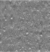
Quick look at the coordinates recently suggested in Chinese media:
This is Mars Odyssey THEMIS infrared with inverted shading -white areas would be dark, or cool, in THEMIS and most are associated with small craters so they are probably blocky. The circle is the site mentioned in recent posts. It's smaller than their landing ellipse, only designed to show the area noted in the media post.
That corresponds to this MRO CTX image (image number is in file name if you save it):
The site is in the upper right corner of this image. Phil -------------------- ... because the Solar System ain't gonna map itself.
Also to be found posting similar content on https://mastodon.social/@PhilStooke Maps for download (free PD: https://upload.wikimedia.org/wikipedia/comm...Cartography.pdf NOTE: everything created by me which I post on UMSF is considered to be in the public domain (NOT CC, public domain) |
||
|
|
|
||
|
Jul 31 2020, 03:14 AM
Post
#55
|
||
|
Solar System Cartographer Group: Members Posts: 10153 Joined: 5-April 05 From: Canada Member No.: 227 |
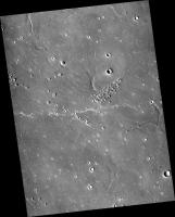
This is the area around that identified point - the image is about 10 km wide. There should be visible crater rims to provide relief in the panoramas. We don't know this will be the site and this is a lot smaller than the landing ellipse.
Phil
-------------------- ... because the Solar System ain't gonna map itself.
Also to be found posting similar content on https://mastodon.social/@PhilStooke Maps for download (free PD: https://upload.wikimedia.org/wikipedia/comm...Cartography.pdf NOTE: everything created by me which I post on UMSF is considered to be in the public domain (NOT CC, public domain) |
|
|
|
|
|
|
Jul 31 2020, 06:59 AM
Post
#56
|
|
|
Merciless Robot Group: Admin Posts: 8783 Joined: 8-December 05 From: Los Angeles Member No.: 602 |
Hmm. Looks a bit dusty (shocker). All those short white streaks are more than a bit intriguing in this view; hopefully they'll be able to reach one.
-------------------- A few will take this knowledge and use this power of a dream realized as a force for change, an impetus for further discovery to make less ancient dreams real.
|
|
|
|
|
Jul 31 2020, 09:13 AM
Post
#57
|
|
 Senior Member Group: Members Posts: 1084 Joined: 19-February 05 From: Close to Meudon Observatory in France Member No.: 172 |
There are lots of pingos south of this site : maybe an hint to the presence of sub-surface ice and/or permafrost

|
|
|
|
|
Jul 31 2020, 01:50 PM
Post
#58
|
||
 Newbie Group: Members Posts: 15 Joined: 19-August 12 From: Zagreb, Croatia Member No.: 6587 |
Here is some info about mission and rover itself.
https://news.cgtn.com/news/2020-07-24/Tech-...Yjh6/index.html https://news.cgtn.com/news/2020-07-25/Tech-...7B2U/index.html
Attached thumbnail(s)
|
|
|
|
|
|
|
Jul 31 2020, 06:19 PM
Post
#59
|
|
|
Solar System Cartographer Group: Members Posts: 10153 Joined: 5-April 05 From: Canada Member No.: 227 |
"All those short white streaks are more than a bit intriguing"
They are dust drifts, perpendicular to the prevailing wind. HiRISE would show them more clearly than CTX does. I expect we will see one up close eventually. Phil -------------------- ... because the Solar System ain't gonna map itself.
Also to be found posting similar content on https://mastodon.social/@PhilStooke Maps for download (free PD: https://upload.wikimedia.org/wikipedia/comm...Cartography.pdf NOTE: everything created by me which I post on UMSF is considered to be in the public domain (NOT CC, public domain) |
|
|
|
|
Aug 1 2020, 05:14 AM
Post
#60
|
|
 Senior Member Group: Moderator Posts: 3233 Joined: 11-February 04 From: Tucson, AZ Member No.: 23 |
Thanks for posting the central coordinates, Phil, I've been wanting to see if CaSSIS has any coverage of the landing site. Any chance for a landing ellipse? The best image I could find was a bit to the southeast.
-------------------- &@^^!% Jim! I'm a geologist, not a physicist!
The Gish Bar Times - A Blog all about Jupiter's Moon Io |
|
|
|
|

|
Lo-Fi Version | Time is now: 27th April 2024 - 10:51 AM |
|
RULES AND GUIDELINES Please read the Forum Rules and Guidelines before posting. IMAGE COPYRIGHT |
OPINIONS AND MODERATION Opinions expressed on UnmannedSpaceflight.com are those of the individual posters and do not necessarily reflect the opinions of UnmannedSpaceflight.com or The Planetary Society. The all-volunteer UnmannedSpaceflight.com moderation team is wholly independent of The Planetary Society. The Planetary Society has no influence over decisions made by the UnmannedSpaceflight.com moderators. |
SUPPORT THE FORUM Unmannedspaceflight.com is funded by the Planetary Society. Please consider supporting our work and many other projects by donating to the Society or becoming a member. |
|