

Phoenix Final Descent Trajectory |

  |
Phoenix Final Descent Trajectory |
 Jul 10 2008, 03:44 AM Jul 10 2008, 03:44 AM
Post
#31
|
|
 Senior Member  Group: Moderator Posts: 2785 Joined: 10-November 06 From: Pasadena, CA Member No.: 1345 |
QUOTE (Pertinax @ Jul 9 2008, 07:59 PM)  And altitude? -- Pertinax I'm pretty sure it's touching the surface. 
-------------------- Some higher resolution images available at my photostream: http://www.flickr.com/photos/31678681@N07/
|
 |
 
|
|
Jul 10 2008, 10:13 AM
Post
#32
|
|
 Senior Member Group: Members Posts: 1465 Joined: 9-February 04 From: Columbus OH USA Member No.: 13 |
QUOTE (Juramike @ Jul 9 2008, 11:44 PM) I'm pretty sure it's touching the surface. Although the present "altitude" reported by the PDS NAIF spice kernel (not sure how accurate) is -2.4 km! That may be correct, insofar as the zero-altitude reference is an idealized tri-axial ellipsoid, which no planet actually fits. So that would place the Phoenix landing site elevation somewhat below mean sea level, so to speak. If I recall correctly, in one of the early press conferences Peter Smith mentioned that liquid water is actually stable in the landing area, due to the low elevation. The lat and lon reported by the spice kernel is 66.217N 243.692E, but how accurate that is I don't know (predicted, actual, tentative?). -------------------- |
|
|
|
|
Jul 10 2008, 10:26 AM
Post
#33
|
|
|
Member Group: Members Posts: 470 Joined: 24-March 04 From: Finland Member No.: 63 |
The position was already reported in an earlier post on this forum
QUOTE 68.218830N 234.250778E, IAU 2000 Areocentric
-------------------- Antti Kuosmanen
|
|
|
|
|
Jul 10 2008, 10:59 AM
Post
#34
|
|
|
Senior Member Group: Members Posts: 1870 Joined: 20-February 05 Member No.: 174 |
At approximately 0 km elevation, the average pressure corresponds to the triple point of water (approximately, and not including seasonal atmosphere pressure variations). So at -100 meters (if this were exact and my arm waving numbers were exact), water 1/2 degree above freezing would not boil. It would evaporate damn fast, though, under most plausible conditions. At lower elevations, water some 5 to 10 deg F <half that for C> above freezing would not boil.
Regardless, it's REAL hard for plausible normal <not impact, for example> processes to supply enough energy to ice at the martian surface to melt it any faster than the water would likely evaporate. |
|
|
|
|
Jul 10 2008, 11:00 AM
Post
#35
|
|
|
Senior Member Group: Members Posts: 1465 Joined: 9-February 04 From: Columbus OH USA Member No.: 13 |
QUOTE (akuo @ Jul 10 2008, 06:26 AM) The position was already reported in an earlier post on this forum Thanks--is that link correct? The original reference doesn't seem to be there. -------------------- |
|
|
|
|
Jul 10 2008, 11:08 AM
Post
#36
|
|
|
Member Group: Members Posts: 470 Joined: 24-March 04 From: Finland Member No.: 63 |
Works for me. I guess this is another way to put it:
http://www.unmannedspaceflight.com/index.p...st&p=115817 -------------------- Antti Kuosmanen
|
|
|
|
|
Jul 10 2008, 01:33 PM
Post
#37
|
|
|
Senior Member Group: Members Posts: 1465 Joined: 9-February 04 From: Columbus OH USA Member No.: 13 |
Hmmm... still don't see it. Anyway, the location you quoted is very plausible based on NAIF spice kernels having MRO pointing squarely at that point at 26MAY2008 22:04:30. The published photo that MRO took of the lander on the ground is stated to have been taken 22 hours after landing (25MAY2008 23:46), so that fits.
Here's a simulation of the view from MRO at that instant, with the HIRISE look direction marked with crosshairs (MGS 200m mosaic, equalized): 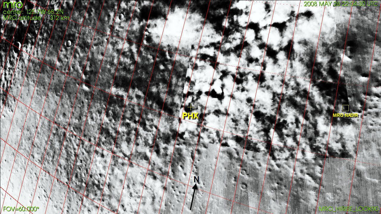 HIRISE had moved pretty far off-nadir to take that shot. I still wonder if part of that mosaic was taken when there were significant clouds over the Phoenix site, and another part when it was clear. -------------------- |
|
|
|
|
Jul 10 2008, 06:09 PM
Post
#38
|
|
 Member Group: Members Posts: 198 Joined: 2-March 05 From: Richmond, VA USA Member No.: 181 |
QUOTE (Juramike @ Jul 9 2008, 11:44 PM) I'm pretty sure it's touching the surface.  Thank you Juramike! Thank you Juramike!  I think I might have misunderstood the initial question, thinking that is was asking if the Lat/Lon (and altitude) of Phoenix in flight at the instant MRO captured it was pin-pointed yet. -- Pertinax |
|
|
|
|
Jul 30 2008, 04:02 PM
Post
#39
|
|
|
Junior Member Group: Members Posts: 89 Joined: 27-August 05 From: Eccentric Mars orbit Member No.: 477 |
I just did my hourly check of the spice kernels at NAIF and found that the EDL reconstruction is posted!
http://naif.jpl.nasa.gov/naif/data_mars.html, phoenix/ck/phx_edl_rec_att.bc, phoenix/spk/phx_edl_rec_traj.bsp Now all we need is an exact time for the entry parachute photograph and we can tell everything about it. |
|
|
|
|
Jul 31 2008, 12:02 AM
Post
#40
|
|
|
Member Group: Members Posts: 340 Joined: 11-April 08 From: Sydney, Australia Member No.: 4093 |
QUOTE (kwan3217 @ Jul 31 2008, 02:02 AM) Now all we need is an exact time for the entry parachute photograph and we can tell everything about it. I havent had a look at it nor do I know what these files show (too busy at the moment), but parachute deploy should show a big spike in deceleration -------------------- |
|
|
|
|
Jul 31 2008, 01:24 AM
Post
#41
|
|
|
Senior Member Group: Members Posts: 1465 Joined: 9-February 04 From: Columbus OH USA Member No.: 13 |
QUOTE (dmuller @ Jul 30 2008, 08:02 PM) parachute deploy should show a big spike in deceleration Good thought. Here's a graph of the speed and acceleration: 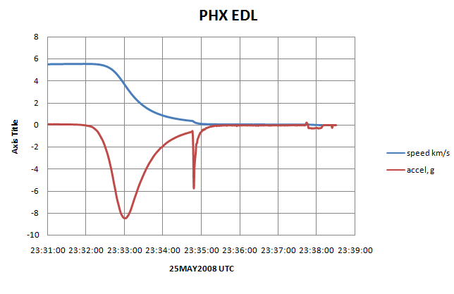 But where along there did MRO take the picture? Anybody know the lat/lon of Heimdal Crater? -------------------- |
|
|
|
|
Jul 31 2008, 02:15 AM
Post
#42
|
|
 Junior Member Group: Members Posts: 96 Joined: 11-February 04 Member No.: 24 |
QUOTE (kwan3217 @ Jul 30 2008, 04:02 PM) I just did my hourly check of the spice kernels at NAIF and found that the EDL reconstruction is posted! http://naif.jpl.nasa.gov/naif/data_mars.html, phoenix/ck/phx_edl_rec_att.bc, phoenix/spk/phx_edl_rec_traj.bsp Now all we need is an exact time for the entry parachute photograph and we can tell everything about it. I also downloaded the files "phx_edl_rec_att.bc" and "phx_edl_rec_traj.bsp". They're binary files. What code did you use to get them into a readable form? |
|
|
|
|
Jul 31 2008, 02:22 AM
Post
#43
|
|
|
Junior Member Group: Members Posts: 96 Joined: 11-February 04 Member No.: 24 |
Hold on, I just found the NAIF website at http://naif.jpl.nasa.gov/naif/toolkit_C_PC..._GCC_32bit.html . I'm downloading the SPICE toolkit tarball while writing this post.
I just got the SPICE tool kit package up and running but it's not friendly. I want the tool kit to translate the Phoenix binary data files into text files describing the vehicle's trajectory in the inertial frame. How do I do that? Does the SPICE database only model the trajectory as a 3-DoF point mass or does it include 6-DoF information from the vehicle's IMU? Thanks! |
|
|
|
|
Jul 31 2008, 04:07 AM
Post
#44
|
|
|
Junior Member Group: Members Posts: 89 Joined: 27-August 05 From: Eccentric Mars orbit Member No.: 477 |
I use the NAIF spice toolkit and IDL, but the one for C works fine too. the .bsp file includes the position and speed (and Spice will convert it to any coordinate system you feel like) while the .bc file contains orientation. Together it is 6DoF.
Look up examples on the NAIF site for spkezr_c for the position stuff. |
|
|
|
|
Jul 31 2008, 06:35 AM
Post
#45
|
|
|
Junior Member Group: Members Posts: 96 Joined: 11-February 04 Member No.: 24 |
Thank you. I'll try it in the morning. Do you know where to find the Phoenix mass model, i.e. moments and products of inertia, center of gravity, etc.? Is there an aerodynamic model specific to the Phoenix 70 deg. aeroshell including Cm, Cmq, etc. accessible on the web? This information would be in the Lockheed-Martin databook for Phoenix but they're probably keeping it close to their vest. Thanks again.
|
|
|
|
|

|
Lo-Fi Version | Time is now: 19th April 2024 - 09:54 PM |
|
RULES AND GUIDELINES Please read the Forum Rules and Guidelines before posting. IMAGE COPYRIGHT |
OPINIONS AND MODERATION Opinions expressed on UnmannedSpaceflight.com are those of the individual posters and do not necessarily reflect the opinions of UnmannedSpaceflight.com or The Planetary Society. The all-volunteer UnmannedSpaceflight.com moderation team is wholly independent of The Planetary Society. The Planetary Society has no influence over decisions made by the UnmannedSpaceflight.com moderators. |
SUPPORT THE FORUM Unmannedspaceflight.com is funded by the Planetary Society. Please consider supporting our work and many other projects by donating to the Society or becoming a member. |
|


