Printable Version of Topic
Click here to view this topic in its original format
Unmanned Spaceflight.com _ Perseverance- Mars 2020 Rover _ Perseverance Route Map
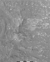
Posted by: Phil Stooke Feb 22 2021, 10:16 PM
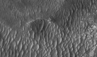
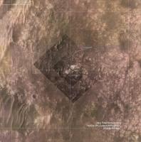
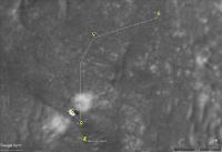
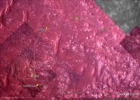
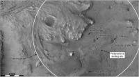
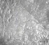
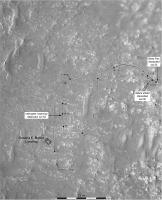
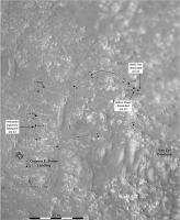
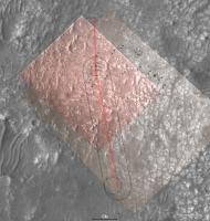
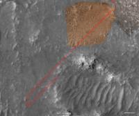
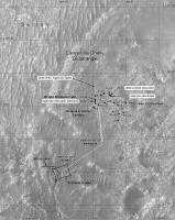
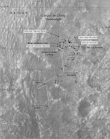
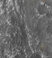
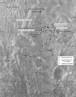
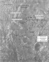
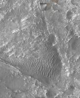
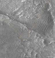
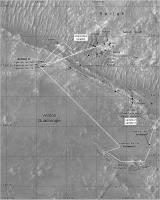
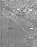
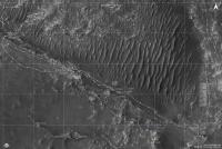
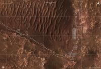
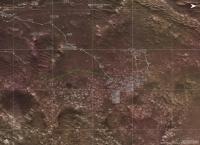
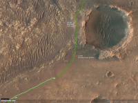
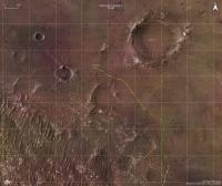
Now we are down safely I am starting a map thread. Everything that happens during 2021 will be covered in my still-in-progress atlas, so I have to make the maps for that and everyone can follow as they evolve.
Let me know if any feature names start to show up.
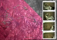
Preliminary map even though not much has happened yet. But if you look closely you will see something, even now.
Phil

|
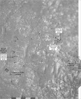
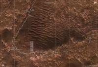
Posted by: kenny Feb 23 2021, 09:11 AM
Lovely stuff, Phil.
Are we seeing evidence of the rock pavement being cleared of dust by the descent engines, to the NE and SW?
And conversely dark streaks towards the NW and SE ?
A very minor observation is that because the gridlines intersect in the middle of Perseverance (as they should), we can't clearly see your lovely little rover symbol!
Looking forward to seeing some white lines appearing soon....
Thanks again.
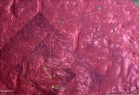
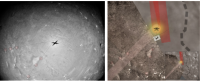
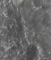
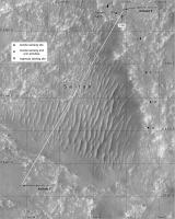
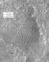
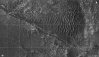
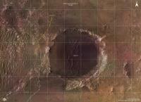
Posted by: Marz Feb 23 2021, 04:39 PM
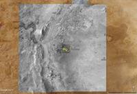
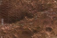
excellent! There's a white blob in the sand-filled crater 1 click SW of the rover. Seems strange for a large boulder to be there, so is that somehow part of the EDL?
Posted by: djellison Feb 23 2021, 05:04 PM
Easy test - go find the location in this map. If it's in this map - it's pre-EDL - it's just natural.
You don't mean this by any chance? This is pre-landing.
|
Posted by: Andreas Plesch Mar 3 2021, 04:37 AM
Following up on http://www.unmannedspaceflight.com/index.php?s=&showtopic=8591&view=findpost&p=250416 I thought it may be useful to easily look up coordinates and measure distances on the map. Here is a bare bones web app (takes a bit to load) to do that:
http://bit.ly/PercyMAP
with reduced texture for mobile
http://bit.ly/PercyMAPm
It is made using https://www.x3dom.org/ and a little javascript. One can zoom in (wheel or right mouse drag), pan (middle mouse drag) and re-center (double left click). The coordinates of the cross-hair are reported and left clicking adds the current position to a list, and calculates the distance from the last recorded point.
For example, it turns out that the wind-carved walrus boulder (harbour seal) is about 12m away from the rover. The used HiRISE DEM has nominally a 1m resolution but seems smoother than that in places, perhaps not picking up all boulders.
I may add a few additional features (controlling shading, continuous reporting of distance to rover) but nothing fancy to keep it really simple.
[edit] There is now a slider to control vertical exaggeration of the elevation model.
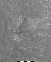
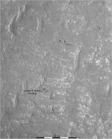
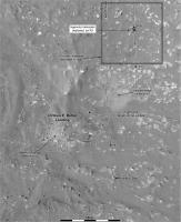
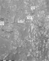
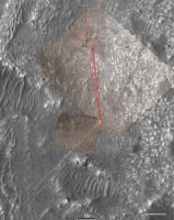
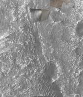
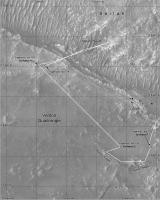
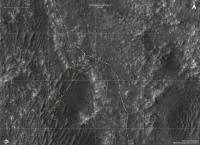
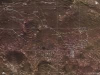
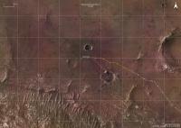
Posted by: Phil Stooke Mar 5 2021, 10:15 PM
OK, first drive, first map. It's a close-up, not the overview provided by the first one I posted, which I will come back to as we move more.
This map uses HiRISE for geometric control, with descent images registered to that for more detail, and the first panorama projected out over that.
Phil
|
Posted by: PDP8E Mar 5 2021, 10:51 PM
... and so it begins... surprise us!
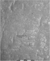
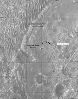
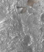
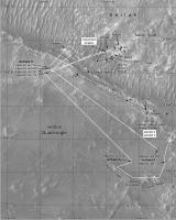
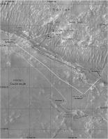
Posted by: Phil Stooke Mar 6 2021, 08:51 PM
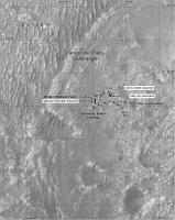
OK, it did surprise me. We are outside my base map on sol 15, so here is a new map for this drive. That's the problem when you are mapping in real time! Fully prepared to have to switch map bases again tomorrow - that will be back to the first one I posted, most likely.
You may notice that my route is offset a few meters from the one on the interactive map on the mission website - they start a bit too close to the drift behind the rover at landing, and the whole path and each site retains that offset. My site locations are based on hazcam images.
Phil
|
Posted by: Andreas Plesch Mar 6 2021, 10:14 PM
I had noticed that offset as well. It seems to me that somehow their rover position to base map registration is a little off.
Looking at the network traffic on https://mars.nasa.gov/mars2020/mission/where-is-the-rover/, it turns out that the traverse and waypoints are plotted with a geojson file.
traverse: https://mars.nasa.gov/mmgis-maps/M20/Layers/json/M20_traverse.json
waypoints: https://mars.nasa.gov/mmgis-maps/M20/Layers/json/M20_waypoints.json
The geojson has the actual coordinates, and one can use it directly for mapping:
The traverse is given by small multiple segments, shown as the grey points. The red waypoints have additional rover orientation data, yaw, pitch and roll. yaw is shown on the map.
https://mars.nasa.gov/maps/location/api/configure/get?mission=M20 is the overall layer configuration. It has the urls of the geojson geometries.
It seem that the web site uses a terrestrial CRS (WGS84) for plotting. Perhaps the rover coordinates are actually for a Mars CRS. That may explain that slight offset depending on the base map projection.
Posted by: kymani76 Mar 7 2021, 12:59 PM

|
My take at the landing map and first drives. It uses combination of Rover Descent Camera footage combined with HiRise image of Perserverance on the ground. Descent stage exhaust marks are also clearly visible.
The geoJSON files are indeed projected to WGS84 datum, so you only need to change that to Mars projection (both sphere and MOLA work) for the track to align in the right place.
The new interface also offers geoJSON updates for Curiosity's position.
Posted by: kymani76 Mar 7 2021, 01:06 PM
|
Another take at the Perseverance's landing map, with all the hardware location marked. Blue line is EDL track from SPICE kernels (looks like a pre-landing solution).
It's curious that the rover landed less than km from 2018 landing ellipse center.
Posted by: kymani76 Mar 7 2021, 02:48 PM
It's already time to update...sol 16
|
Posted by: Andreas Plesch Mar 7 2021, 03:23 PM
And here is my take:
I am assigning CRS ESRI:104971 - Mars_2000_(Sphere) - Geographic to the geojson coordinates, and use the equirectangular projection for plotting which is native to the HiRISE mosaic.
The arrows show the yaw orientation at the way points.
The little circles along the path are where positions are actually provided in the traverse geojson.
We are getting outside the range of the EDL Rover Downlook imagery. Perhaps it is worth looking through those again to see if there is one covering the new terrain in higher detail than the 25cm HiRISE mosaic.
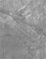
Posted by: Phil Stooke Mar 7 2021, 07:10 PM
Map updated to sol 16. I hope for some feature names to add to it, eventually. I will have to re-think my earlier maps a bit. The sol 16 site is just a tiny bit outside the edge of the last map so I can probably adjust it.
It's great to see these alternative views of the traverse here.
Phil
|
Posted by: Julius Mar 7 2021, 07:26 PM
Dont know if its the correct site to post this but looking at the orbital view, the rock pavement next to where the rover is sitting right now looks morelike sedimentary to me rather than a lava field and yet i am no geologist so who knows.
Posted by: Andreas Plesch Mar 7 2021, 10:39 PM
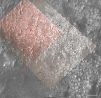
I did find a slightly earlier frame of the Rover Lookdown camera which has a bit of the current location and is higher resolution than the HiRISE mosaic. It is a bit blurry because the Descent Stage had not fully stabilized and is from a more oblique perspective. But the registration went pretty well. Here is how the map looks with that frame (and higher contrast):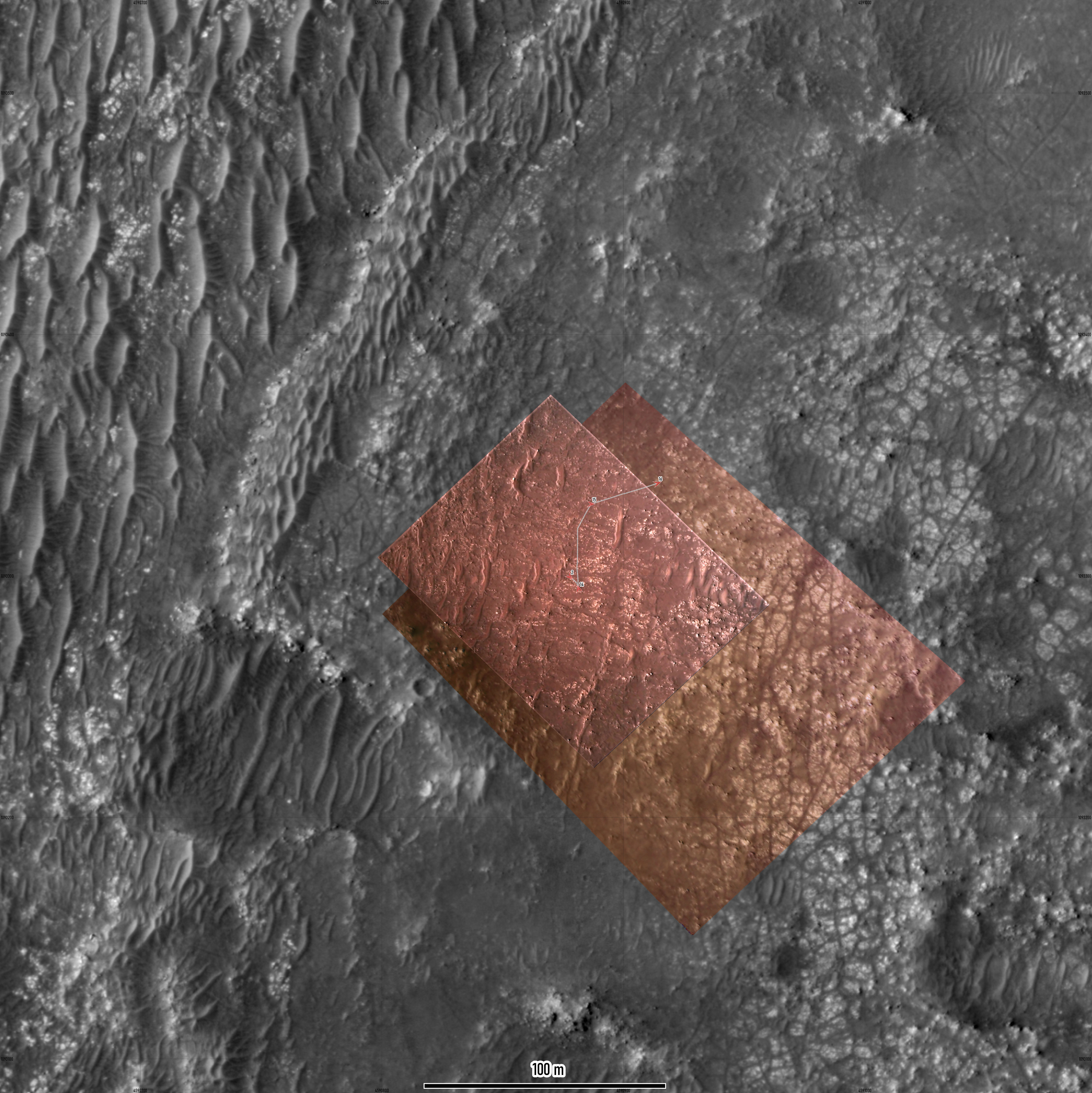
The width of the traverse path is 0.5 m.
The boulders are imaged quite a bit better than in the HiRISE mosaic.
Posted by: Phil Stooke Mar 10 2021, 03:21 AM
I revised my map from earlier to include the sol 16 drive.
Phil
|
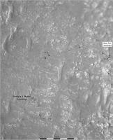
Posted by: Phil Stooke Mar 10 2021, 09:27 PM
Iteratively building these maps. I have added the two SuperCam target names now, one on each map.
Phil
|
|
Posted by: MarkL Mar 10 2021, 09:45 PM
Thanks as always Phil. This is a great resource.
Posted by: markril Mar 10 2021, 10:34 PM
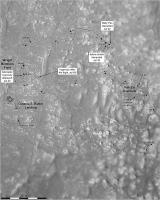
For those of you who might want to navigate this trip with Google Mars/Earth, as well, I've prepared some overlays using the large https://astrogeology.usgs.gov/maps/mars-2020-jezero-crater-landing-site-controlled-orthomosaics created by the USGS that were mentioned earlier in this thread.
The overview map is 5322x5040 with 6m/pixel resolution:
|
The larger 6.9GB map was broken into manageable 4000x4000 tiles with 0.25m/pixel resolution:
|
You can see some overlays of the various HiRISE and rover downcam images.
For the rover track, I cobbled together a script that scrapes the "Where is Perseverance?" web page. Right now I have to run the script manually, but plan to automate it once I can make it more robust.
You can download a http://vps78674.vps.ovh.ca/Mars2020/GoogleMars/mars2020.zip (55MB) with everything or download files individually at the http://vps78674.vps.ovh.ca/Mars2020/GoogleMars/.
Additional map tiles will be added to the site soon to accommodate the planned route.
The elevation data currently used by GE is low resolution, so only the largest features like the crater rim render well with everything else looking kind of flat.
One thing I like about GE is that it provides an easy way to geolocate the interesting images presented in this forum for future reference.
Mark
Posted by: markril Mar 11 2021, 04:57 AM
... and to continue the discussion on registration of the json track data from the "Where is Perseverance?" page with the USGS basemap, here's the post-landing HiRISE image layered on top of the Google Earth tiles:
|
This overlay and the downcam overlays (below) were manually registered (to the best of my ability and patience) with the Google Earth tiles derived from the USGS basemaps. These tiles were extracted from the original equirectangular basemap with a program using the supplied metadata (so no human inaccuracies).
|
So, yeah, there seems to be general agreement with the other maps here...

Mark
Posted by: Phil Stooke Mar 12 2021, 12:30 AM
This is the sol 20 drive. The location should be good, the path is an estimate.
Phil

|
Posted by: Andreas Plesch Mar 12 2021, 02:55 AM
Here is my best estimate of the current location, at sol 20 after the drive:
The rectangle is the approximate foot print of the rover, to scale.
This is mostly based on analysis of this Navcam image:
Starting from the dark, small, almost boulder free crater in the middle ground (apparently a word), I believe one can identify sets of boulders to track back to the rover. I guess we will see soon enough.
The crater seems really smooth and may be a good arena for heli testing. There are a few ripples, so perhaps the rover would not venture inside.
Posted by: kymani76 Mar 12 2021, 09:13 AM
|
Sol 20 update with newly available raw EDL images.
I would not recommend GE for geo-referencing of images as it only allows 4 (corner) control points.
Posted by: Andreas Plesch Mar 12 2021, 01:42 PM
My estimate was a few meters off. With the latest geojson:
The width of the path corresponds to the width of the rover (ca. 2.7m).
https://mars.nasa.gov/mmgis-maps/M20/Layers/json/M20_waypoints.json now also has a few more fields: distance, drive and elevation among them.
In the helicopter introduction last night, they mentioned that its range could be about 100m x 30m, after initial shorter tests.
Posted by: markril Mar 12 2021, 07:16 PM
For the Google Mars track, there's now an automatic update ability available for the client side. What this means is that Google Mars will check for an update every 6 hours (while GM is open) or you can manually refresh the track. This will download the track from my server. However, the track on my server is still only updated manually by me running a script so there will be some (human induced) latency until I fully automate the back-end (which will be soon).
Download & open http://vps78674.vps.ovh.ca/Mars2020/GoogleMars/updates/track-updater.kmz and move it to the "mars2020" folder on the GM side panel. You can delete the old "track sols 2-16" folder. The new "track-updater" folder will automatically refresh in the future. To manually refresh, there's a refresh menu item when right-clicking track-updater. If you want, you can change the refresh interval or disable it by going to the Properties>Refresh tab.
Here's a look at the current track:
|
Note: While all the waypoints and traverses are displayed correctly, they are listed out of order on the side panel. This will be fixed in the next automatic refresh now that I've studied the json data a little closer.
Mark
Posted by: Phil Stooke Mar 15 2021, 08:26 PM
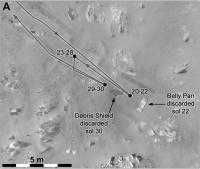
The images for the last couple of days have not been helpful for making panoramas so it's taken a while to get to this map. Update to sol 23 - a drive back along the tracks away from the belly pan.
Phil
|
I register my maps to the HiRISE orthophotos, so they share projection details with those images. There may be small mis-matches between the various maps appearing in this thread but they are not worth worrying about, they all tell essentially the same story.
Posted by: Andreas Plesch Mar 16 2021, 12:12 AM
Here is a map using the latest geojson, with registered EDL downlook imagery. The width of the path is 2.7m, the black circles are 1m in diameter. The faint arrows show yaw as reported in the way points. The projection is orthographic, centered at the landing ellipse (77.4298 E, 18.4663 N).
Posted by: nprev Mar 16 2021, 03:50 AM
Some members have observed, and I agree, that this thread has drifted a bit from its intent. For our new members, Phil's map threads have generally served as navigation/situational awareness reference resources on UMSF for every rover since Spirit to help us all follow the journeys in those ways. Naturally, some questions and observations occasionally pop up in them but this has turned into a full-blown tech discussion.
I was gonna create a new Mars Cartography thread, but lo and behold it turns out that http://www.unmannedspaceflight.com/index.php?showtopic=2743&st=80&start=80. 15 posts have been moved there, and I encourage all to please continue that most interesting and informative discussion there. Thanks! 
Posted by: Phil Stooke Mar 16 2021, 07:42 AM
Good idea.
I have adjusted the base of my intermediate scale map to include the Belly Pan location, so here is an update to sol 23.
Phil
|
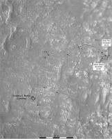
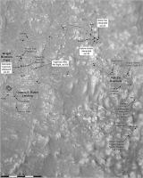
Posted by: Phil Stooke Mar 16 2021, 07:07 PM
This map shows feature names around the landing area mentioned at LPSC today. There are some diacriticals which I have not figured out yet, but which will be added later.
Phil
|
Posted by: kymani76 Mar 16 2021, 10:59 PM

|
sol 23 update
Only Rover Descent Camera images are used.
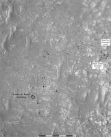
Posted by: Phil Stooke Mar 17 2021, 09:19 PM
This is my previous map with the appropriate characters added.
Phil
|
Posted by: Phil Stooke Mar 21 2021, 09:40 PM
Sol 30 update:

|
Phil
Posted by: kymani76 Mar 22 2021, 08:42 AM
|
map update
Posted by: Phil Stooke Mar 22 2021, 11:34 PM
Using Hazcams I have plotted the path to sol 31.
Phil
|
Posted by: Phil Stooke Mar 23 2021, 09:19 PM
The partial panorama in the early drives thread gives the path and location for sol 32.
Phil
|
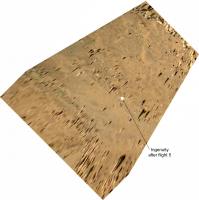
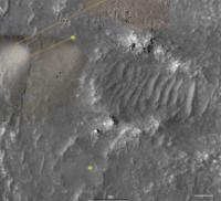
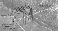
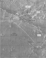
Posted by: Art Martin Mar 24 2021, 01:07 AM
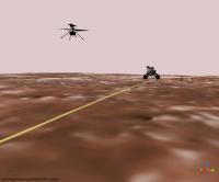
Phil, I took your route map and superimposed a photo from JPL of the flight zone of Ingenuity. You can see they got very close to the drop off point with the latest drive.
https://flic.kr/p/2kNAz4ihttps://flic.kr/p/2kNAz4i
Posted by: Phil Stooke Mar 24 2021, 02:08 AM
Thanks! Very useful.
Phil
Posted by: Andreas Plesch Mar 24 2021, 02:45 AM
Another map based on the NASA geojson with simulated wheel tracks, 2.7m apart, pills from the traverse data, yaw arrows at way points, the airfield target and the overlook position:
And a full map with more context:
Posted by: kymani76 Mar 24 2021, 10:18 AM
|
Sol 32 update.
Posted by: Phil Stooke Mar 25 2021, 03:15 AM
We have just 5 images from sol 33 down from Perseverance as I write this, but with one Navcam and one rear Hazcam there is enough information to approximate the drive:
|
Phil
Posted by: Andreas Plesch Mar 25 2021, 10:43 PM
sol 33 update: The flight zone is 30m wide in this map.
full map
Posted by: Phil Stooke Mar 26 2021, 06:51 AM
Quick update for the drive to the airfield on sol 34.
Phil
|
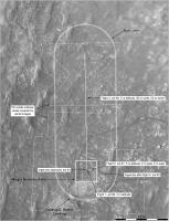
Posted by: pospa Mar 26 2021, 09:00 AM

Phil, could you please (at least for the Ingenuity test period) mark the Helipad (3x3 m) and Airfield (10x10 m) borders into your map for our better orientation?
Thanks
Posted by: kymani76 Mar 26 2021, 10:34 AM

|
Sol 34 map update. Colored using merged RGB HiRise image.
|
Airfield closeup.
Posted by: kymani76 Mar 26 2021, 01:17 PM
|
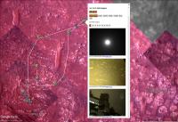
https://arkeomapia.si/3d/mars2020/index.html
3D version of the map showing the flying zone. Not perfect, but you can pan around freely.
Posted by: MarkL Mar 26 2021, 01:31 PM
[quote name='Andreas Plesch' date='Mar 25 2021, 10:43 PM' post='251192']
sol 33 update: The flight zone is 30m wide in this map.
So nice. Thank you!
How did you place the tracks? Visual references or are they just parallel to the path?
Posted by: Andreas Plesch Mar 26 2021, 04:00 PM
Glad that it is useful. Making the maps helped me understand the area better. The simulated tracks are just parallel to the traverse path from the geojson data, with an offset to indicate the 2.7m width of the rover. I think the plotted track marks are 40cm wide. I could not figure out if the cited 2.7m width refers to just the body of rover, or if it includes the wheels sticking out on the sides. I am using QGIS which makes makes it possible to do all that pretty quickly and accurately. It would be nice to simulate the rotational turns but I am not sure if there is enough data available (other than the imagery) and also do not have an idea how at this point.
Posted by: MarkL Mar 26 2021, 11:39 PM
Thanks Andreas. Keep up the great work!
Posted by: Andreas Plesch Mar 27 2021, 02:10 AM
sol34 update: larger airfield to avoid crowding, simulated tracks 2.7m wide from outer edge to outer edge (I think more correct), track marks 30cm wide. Flight zone 30m wide.
full map:
Posted by: Phil Stooke Mar 27 2021, 06:37 AM
A special map for the area where the belly pan and debris shield were dropped. This is another use for the circular panoramas - they can be warped a bit to fit a HiRISE (or descent camera) image base.
Phil
|
Posted by: markril Apr 3 2021, 06:21 AM
Here's the latest addition to the Google Mars project I've been working on:
|
Basicly, it's an image browser for Google Earth that organizes available raw images according to their geographical coordinates. The coordinates are derived from the image metadata. The raw images are generally released prior to updates to the "Where is Perseverance?" page so this gives advance knowledge of the rover position as determined by the navigation team. In any case, you can just view the images and make your own determination as I like to do.
|
The following web page contains further information and downloads:
http://vps78674.vps.ovh.ca/Mars2020/GoogleMars/
Mark
Posted by: Phil Stooke Apr 4 2021, 03:05 AM
Interesting! Thanks.
Here is a map update for sol 43.
Phil
|
Posted by: Phil Stooke Apr 4 2021, 09:28 PM
I have added recent drives and the helicopter deployment to my close-up map.
Phil
|
Posted by: htspace Apr 6 2021, 01:06 PM
|
|
Basicly, it's an image browser for Google Earth that organizes available raw images according to their geographical coordinates. The coordinates are derived from the image metadata. The raw images are generally released prior to updates to the "Where is Perseverance?" page so this gives advance knowledge of the rover position as determined by the navigation team. In any case, you can just view the images and make your own determination as I like to do.
|
|
The following web page contains further information and downloads:
http://vps78674.vps.ovh.ca/Mars2020/GoogleMars/
Mark
That's great, thank you!
Posted by: kymani76 Apr 7 2021, 09:21 PM
|
Sol 44 3D map view roughly matching today's self portrait.
Posted by: Phil Stooke Apr 8 2021, 06:42 AM
We had a good drive on sol 47, probably about as long as the longest one to date at 35-40 m or so - I don't know the path at the start of the drive yet. We don't have a full panorama yet but the location should be fairly good.
Phil

|
Posted by: markril Apr 8 2021, 07:02 AM
I mentioned in my last post that the raw-image metadata can be used to plot the position of the rover prior to the official geojson track being available and here's an example for sol 47. Image locations are the blue squares:
|
These coordinates appear to be based on the rover's dead reckoning abilities. Once the official track comes out with the latest localization, the image locations can be refined by distributing the error along the last traverse. This is all discussed (in great detail) in this oft-mentioned https://pds-imaging.jpl.nasa.gov/data/msl/MSLPLC_1XXX/DOCUMENT/PLACES_PDS_SIS.PDF.
One other interesting thing to note is that a stereo pair of Navcam images are generally downlinked 7-8 meters prior to the spot where the rover stops. Presumably this is an easy way to get an idea of what exactly is under the rover.
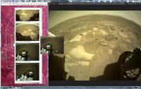
Posted by: htspace Apr 8 2021, 07:32 AM
Phil
|
|
Perseverance has moved 38.43 meters on Sol 47. In total, it has already covered a distance of 229.74 meters.
Posted by: Phil Stooke Apr 9 2021, 07:05 AM
Another drive on sol 48, getting closer to the overlook.
Phil
|
Posted by: Phil Stooke Apr 10 2021, 07:16 AM
Sol 49 - closer to the overlook, but not yet at the exact point denoted earlier. I don't suppose they really have to worry about being exactly on it. This location comes from the Hazcam projection I just posted in the Early Drives thread.
Phil

|
Posted by: kymani76 Apr 13 2021, 06:13 PM
|
Sol 52 update. Flight set up (almost?) complete.
Posted by: Phil Stooke Apr 14 2021, 12:10 AM
And my map for sol 52.
Phil

|
Posted by: Andreas Plesch Apr 17 2021, 07:55 PM
I had been away from my qgis setup. Here my update for sol 59, with new labels:
and the full map:
Posted by: Andreas Plesch Apr 24 2021, 03:46 AM
I tried my best to register the high resolution helicopter overhead perspective, using about 40 control points:
The helicopter lens seems to be wide angle, fish-eye, with heavy distortion away from the center. So I used rubber sheeting ( thin plate spline ) to generate a map:
Since I did not use the tracks for referencing, the good match between the actual and simulated tacks shows that referencing of the rocks went well, and that the base map was also well registered.
Posted by: Andreas Plesch Apr 26 2021, 02:50 AM
I registered the second oblique helicopter view along the flight zone, clipping the highly distorted, more distant view. Here is a composite map of the flight zone which Ingenuity traversed to today, probably for about 50m.
Posted by: Phil Stooke Apr 26 2021, 11:19 PM
A short drive which I was not expecting on sol 65, pointed out by Paul in the other thread... Using Navcams I find a location hastily mapped here. I will fix up the base later.
Phil
|
Posted by: Andreas Plesch Apr 27 2021, 01:06 PM
For what it's worth I registered the third helicopter perspective (to the west) to the map:
Here the larger flight zone:
Posted by: MarkL Apr 27 2021, 01:27 PM
I'd say its worth a lot Andreas. Thanks.
Posted by: Andreas Plesch Apr 27 2021, 07:37 PM
Thanks. Since I used rocks and pavement patterns to register the images to the EDL basemap, it was an interesting exercise to get to know a large number of these features more closely in the vicinity of the airfield, and some larger ones in the distance. With real photogrammetry and knowledge of the lens and camera orientation one could do a better job but this is pretty good on a cm scale.
Posted by: Andreas Plesch Apr 28 2021, 01:06 AM
Updated maps to sol66:
full map:
Posted by: Antdoghalo Apr 28 2021, 02:25 AM
Just to think, we are mapping the first controlled flight paths on Mars!
Posted by: Phil Stooke Apr 28 2021, 03:38 AM
I will have a map of flight paths eventually! For now an update after a short drive on sol 66, well behind Andreas in getting to this. I am reverting to a smaller scale map until I have a better sense of where we are going.
The offset between real positions and the JPL map continues - it's about 1 rover length. The maps on here are all corrected.
Phil

|
Posted by: Andreas Plesch Apr 28 2021, 08:21 PM
A mosaic of the four Ingenuity images, registered to a base map:
I used Thomas' straightened version (thanks !) hoping that it would behave favorably in the distance but I had to crop anyways. (In fact, I think it made interpolating between control points perhaps less robust than the original would have.)
Posted by: Phil Stooke May 1 2021, 09:26 PM
Good stuff, Andreas!
Here is my more detailed map updated to sol 69. I will add descent images to the lower part soon.
Phil
|
Posted by: markril May 4 2021, 12:59 AM
http://vps78674.vps.ovh.ca/Mars2020/GoogleMars/ for sol 72:
|
Position is dead reckoning but looks within a meter or two.
Posted by: Phil Stooke May 4 2021, 02:10 AM
Good location! Here's my version.
Phil

|
Posted by: Andreas Plesch May 4 2021, 04:06 AM
another take:
https://user-images.githubusercontent.com/6171115/116959645-2e68d600-ac6c-11eb-99b7-4ff88ed8904a.png
Posted by: Phil Stooke May 5 2021, 12:20 AM
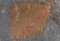
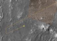
A short drive on sol 73 crosses a sandy patch as shown at small scale here. The sites indicated by squares are where arm instruments were apparently used, though without daily updates I don't know much.
Phil
|
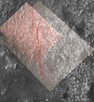
Posted by: Andreas Plesch May 5 2021, 03:31 PM
A sol73 map using the updated geojson for the traverse:
|
The orange lines bracket the destination of flight FOUR, with the circle denoting a rough best guess.
Posted by: Phil Stooke May 7 2021, 12:36 AM
I'm still trying to decide what map coverage Ingenuity will get, but here is a first attempt covering the first 3 flights plus the landed location after Flight 4. I show the approximate coverage by Ingenuity's forward-facing camera based on mapping by Andreas and a tentative additional image, not yet released, looking north on flight 3.
Phil
|
Posted by: Andreas Plesch May 7 2021, 02:38 AM
I registered https://mars.nasa.gov/resources/25891/hirises-view-of-ingenuitys-fourth-flight-path/ and digitized the paths for flights 3 and 4:
|
There are also outlines of the mapped DEMs along the paths. I am relieved that my estimate (orange) of the path and destination (circle) turned out accurate enough. In fact, I would have expected that the 3d scan would be centered along the flight path but it is shown a bit off-center in the released map. Perhaps it will be worth to map out the path of Ingenuity's shadow from the released flight 4 sequence.
Friday's flight 5 apparently will track flight 4 (as much as possible) and so should end up in the circled area.
Posted by: Phil Stooke May 7 2021, 06:10 PM
Great work, Andreas. Here is a map for Ingenuity's flight 4 - the next flight will be added to this later. I have deviated a bit from Andreas's map by showing the return path leading to the actual landing point. Ingenuity landed east of its original position after flight 4, and of course the fifth flight will also depart from there.
Phil

|
Posted by: kymani76 May 8 2021, 10:55 AM
|
And my version....
Posted by: Thorsten Denk May 8 2021, 11:41 AM
How did you pinpoint the return point with centimeter-precision ("131.46 m")? 
Thorsten
Posted by: kymani76 May 8 2021, 11:50 AM
It's a GIS derived value from the midpoint to the landing point. There are of course uncertainties in Ingenuity's and midway point position.
Should have really rounded up the number.
After some thought I think they moved the azimuth of the south flight zone area slightly to the SE direction in order to fit the descent camera coverage.
Posted by: kymani76 May 8 2021, 06:45 PM
|
Sol 77 / flight 5 update. Landing location estimated from Mastcam imagery. The official distance reported is 129m, but I get only 122.5m from the take-off and landing postions.
Posted by: Andreas Plesch May 8 2021, 07:05 PM
https://mars.nasa.gov/resources/25900/nasas-ingenuity-mars-helicopter-fifth-flight-lands-in-new-airfield/
has a short video which includes this image of 'about where we landed':
|
This looks to me very similar to the flight 4 destination image so we may have ended up there.
[Apparently, the color camera on the helicopter is called the Return To Earth Cam, for reasons only known to the team].
Posted by: Phil Stooke May 8 2021, 09:27 PM
This is a Mastcam-Z image pre-landing, roughly stretched to help estimate the landing location. By comparing with post-landing images I have added a likely landing point. It is a bit further out than on Kymani76's map, closer to the end of the previous flight. The 2 big rocks just above the midpoint of my arrow are visible in the descent image basemap.
Phil
|
Posted by: Phil Stooke May 16 2021, 06:55 AM
Sol 84 - a drive to the west (a bit north of west really), possibly positioning for a nice smooth drive south to get closer to Ingenuity.
Phil

|
Posted by: Andreas Plesch May 16 2021, 11:42 PM
sol 84 update from the updated waypoint and traverse geojson, and with a rough estimate of Ingenuity at its new airfield:
|
Posted by: Phil Stooke May 18 2021, 11:45 PM
Just a short drive on sol 86, to put a knobbly rock in reach. We are back in the area of my more detailed map.
Phil
|
Posted by: Andreas Plesch May 22 2021, 04:04 AM
Based on the flight 6 announcement and the high resolution color image from Ingenuity probably from when hovering high above its landing sight I made maps of the imaged area and of how flight 6 could look like:
|
It gives me confidence that the flight 5 landing location is not far off.
There is potential to improve the mapping by adding more control points. Hopefully I will find time to do that since it would improve on the HiRISE mapping.
The field of small, triangular dunes, and the east-west striping on the ground are among the features which could not be detected on the HiRISE images.
This is just a visualization of a potential flight path based on the description in the announcement. If I did that correctly, t works out for landing on the rugged crater rim (!).
|
The idea that drones could explore places inside craters not accessible by rover may be tested soon.
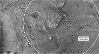
Posted by: Phil Stooke May 23 2021, 06:48 PM
Sol 91 - a shortish drive to the south, maybe 25 m. The location is based on a partial panorama.
Phil

|
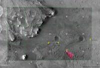
Posted by: Station May 24 2021, 05:50 AM
Phil
|
|
Hi Phil,
Is this white rectangle (sol 76 - Airfield "B") the last landing location of Ingenuity? Is the Field C next possible target for little helicopter?
Posted by: Phil Stooke May 24 2021, 06:26 AM
The symbol is the approximate location of the helicopter landing after flight 5 - still hoping for a new picture after the latest drive to nail down the position a bit better. Field C is the (approximate) next landing site.
Here is another version of the map.
|
Phil
Posted by: Andreas Plesch May 27 2021, 04:02 AM
A larger map with the json traverse to the current site, the helicopter aerial image at the end of flight 5, now more carefully georeferenced, and a tentative flight 6 path, based on the narrative provided in the update news item. The current location of Ingenuity on the map may well be a little off.
|
Posted by: Phil Stooke May 28 2021, 12:29 AM
This is my best guess at the moment for flight 6. I'm still not certain I have the end of flight 5 location correct. Flight 6 runs roughly SW for about 150 m, and where it stops it takes the aerial view out over the landscape, the one which has just been released. Then it runs south for about 20 m, and that's where the video starts. From there it runs NE and then turns a bit and moves north before landing. That landing point is right on Andreas's vector. Subject to modification!!! (as always).
Phil
|
Posted by: Andreas Plesch May 28 2021, 01:13 AM
Phil
|
|
Thanks for giving flight 6 a try. I get the same spot for the location of the aerial view, and it is likely that the small spidery dunes in this area are the same which are shown in the video. Running south, and then turning sharply back to the NE (as planned) would also pass by the small crater as seen in the video. But I am not sure I can see the required sharp turn by a counterclockwise 135 degree from S to NE in the video. There is a turn but it looks more like 45 degrees. I will need fresh eyes to look again at the map, the panorama, and the video.
Posted by: Phil Stooke May 28 2021, 02:38 AM
I have plotted (rather roughly) the outlines of the oblique color press release view and the first frame of the video on the last map, and it's clear that my flight 6 path needs to be moved north, which will remove the need for the last little bend in the path. I will post a new version shortly.
Phil
|
Posted by: Phil Stooke May 28 2021, 02:43 AM
Very shortly! Here it is.
Phil

|
Posted by: Andreas Plesch May 31 2021, 01:36 AM
I noticed that on the heli nav images at the vertical landing portion of flight 5, it is possible to draw close to radial lines through ground features, after contrast enhancement, which allow triangulation of the shadow and therefore of the landing location. As the projection from the fisheye lens appears to be centered on the image, the radial lines should appear straight on a map. I could then use my earlier map to get a handle on the position of Ingenuity after flight 5:
|
There is still some wiggle room but the location should be better than my earlier estimate (yellow). I will update the map.
Posted by: Phil Stooke May 31 2021, 03:42 PM
Sol 99 - we just had a short drive to another rock.
Phil

|
Posted by: MarkL Jun 1 2021, 04:16 PM
Great forensic work!
Posted by: Phil Stooke Jun 2 2021, 02:34 AM
Yes, good work. I'm moving my flight 5 destination to comply with it. Here's an updated version of the map as it is at present. I'm still trying to decide if the Rice U. map Andreas linked to should be used for flight 6.
Phil

|
Posted by: Phil Stooke Jun 4 2021, 02:28 AM
Update to sol 102, with flight 6 from the new JPL map.
Phil

|
Posted by: Phil Stooke Jun 4 2021, 10:08 PM
Update to include the sol 103 drive and the location of the next helicopter landing site, which I am assuming will be called Field D.
Phil

|
Posted by: Andreas Plesch Jun 5 2021, 03:00 AM
The geojson for the helicopter flight path:
https://mars.nasa.gov/mmgis-maps/M20/Layers/json/m20_heli_flight_path.json
and helicopter waypoints:
https://mars.nasa.gov/mmgis-maps/M20/Layers/json/m20_heli_waypoints.json
Posted by: Andreas Plesch Jun 5 2021, 03:53 AM
Here is my take for sol 103 using now the geojson for the helicopter path:

|
The width of the flight path is 1.2m which is the wing span of the blades and should be comparable to the size of the shadow in the nav images.
The geojson of the flight path does not have intermediate points, only the end points of the straight segments.
The circle for the destination of flight 7 is 20m in diameter.
And here is a close-up of the potential area for the next rover drive:

|
Posted by: Phil Stooke Jun 5 2021, 10:38 PM
Very nice map! Here is my version updated to sol 104.

|
Phil
Posted by: Andreas Plesch Jun 6 2021, 05:22 PM
Here another take for sol 104 using the geojson:

|
And a close up looking forward:

|
The rover path plots a bit closer to the small but distinct crater the rover just passed than shown on the online map. The Hazcam images and Phil's path are very consistent to what is shown here. Not sure why the online map is a bit different.
Posted by: Andreas Plesch Jun 6 2021, 08:59 PM
A 28m drive on sol 105, penciled in here, based on Hazcam images:
|
Posted by: Phil Stooke Jun 7 2021, 06:26 AM
And my map updated - the new position and route just taken from the JPL map at this stage - but correcting for the offset in the online map.
That offset has persisted since the first map on the website. Either the rover locations and path are slightly off or the base map is slightly off relative to absolute coordinates - I don't know which. But there is a clear misregistration between the path and the base map. It's only about 1.5 or 2 m so not a big concern.
Phil

|
Posted by: Andreas Plesch Jun 7 2021, 01:31 PM
The thing is both the original HiRISE map data (geotiff) and the path geojson seem to actually register correctly, with respect to each other, and most likely in terms of latitude and longitude. This leaves perhaps the web mapping software which is leaflet. Leaflet probably assumes coordinates are for the planet Earth which should still be ok for plotting. Perhaps somehow elevation is considered for the path and not the map. Or perhaps tiling the map introduced an offset. Not a big deal but something to be aware of.
Posted by: Andreas Plesch Jun 8 2021, 12:28 AM
Here json based rover path to sol 105:
|
Posted by: Phil Stooke Jun 9 2021, 03:26 AM
My map update to sol 107 with the Ingenuity flight and a short drive.
Phil
|
Posted by: Phil Stooke Jun 9 2021, 10:06 PM
A shortish drive, 20 m or a bit more, on sol 108. I only have Hazcams to go on so far but it looks like we are getting close to the sol 91 helicopter landing site.
Phil

|
Posted by: Andreas Plesch Jun 10 2021, 01:45 AM
A large sol 107 map with added overlays of helicopter RTE images carefully registered to the HiRISE map. Perhaps the rover will venture into those areas.

|
Posted by: Andreas Plesch Jun 11 2021, 01:01 AM
A sol 109 map focusing on the crater and route to Ingenuity.
|
Posted by: Phil Stooke Jun 11 2021, 03:05 AM
My map for sol 109.
Phil

|
Posted by: Andreas Plesch Jun 12 2021, 02:58 AM
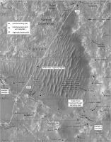
The map for sol 110 shows the simulated tracks of the last drive and to the South the area of the path to a potential first excursion into the Seitah.
|
Since the base map is the same as is used on the project page, there is not much added value here.
Posted by: Phil Stooke Jun 12 2021, 03:33 AM
Sol 110, a quick map update.
Phil

|
Posted by: kymani76 Jun 12 2021, 09:48 AM

|
Sol 110 map update
Posted by: Andreas Plesch Jun 13 2021, 02:13 AM
Since there is now a JPL provided sol107 heli location, here an update to the sol110 map, looking ahead to the south, centered on the border of the Seitah region.
The JPL location is the open circle next to the yellow marker. The simulated rover track is to scale.

|
The potential excursion into the Seitah region was shown just north of the large crater at the southern margin of the map. It may be a handful drives away.
Posted by: Phil Stooke Jun 15 2021, 11:14 PM
Sol 113, continuing southwards.
Phil

|
Posted by: Andreas Plesch Jun 16 2021, 01:38 AM
My sol 113 map:
|
Posted by: Phil Stooke Jun 18 2021, 03:53 PM
Sol 116, a drive which brings us close to the edge of Seitah, probably to enter a safe path to the south.
Phil

|
Posted by: Andreas Plesch Jun 19 2021, 02:30 AM
Here my json based map for sol 116, with an estimate for the destination of flight 8. on or after Monday, 6/21.
|
The center of the 20m radius circle is about 160m from the current location of Ingenuity. It covers a smooth looking area which seems to make for a nice air field. There is another, smaller, smooth area about 50m to the west which may be another candidate.
Posted by: Phil Stooke Jun 22 2021, 07:28 AM
Sol 120 - no rover movement but a nice Ingenuity flight to Airfield E. The location is from the descent image sequence.
Phil

|
Posted by: Andreas Plesch Jun 22 2021, 12:52 PM
Here my sol 121 map with Ingenuities new location:
|
I have added 1m (dotted) and 5m (solid) contours since the border to the Seitah has more topographic expression. The contours also show how horizontal layers may be exposed at the bottom of the larger crater just south of Ingenuity.
Posted by: Andreas Plesch Jun 25 2021, 01:55 AM
The sol 122 map after the geojson update, with a larger view of the Seitah:

|
Posted by: Phil Stooke Jun 25 2021, 06:43 AM
Sol 122 map update. Looks like this could lead in to an interesting examination of the bright rocks in Seitah.
Phil

|
Posted by: Phil Stooke Jun 25 2021, 08:37 PM
Moving south again, no stop at Seitah.
Phil

|
Posted by: Andreas Plesch Jun 25 2021, 09:32 PM
sol 123 update with geojson path and black contours on brighter imagery:
|
Posted by: Phil Stooke Jun 26 2021, 07:29 PM
Sol 124, a short drive.
Phil

|
Posted by: Andreas Plesch Jun 27 2021, 01:23 AM
My sol 124 update:
|
Posted by: Phil Stooke Jun 28 2021, 08:11 PM
Sol 126, a drive to the south, maybe within view of Ingenuity for a close-up image.
Phil

|
Posted by: Phil Stooke Jun 29 2021, 06:53 PM
Sol 127, continuing south. There doesn't seem much point going further south here because of rough terrain ahead, so we will probably turn east and drive through Airfield E, and then south again.
Phil
|
Posted by: Andreas Plesch Jun 29 2021, 11:17 PM
Thanks, very helpful. I am away from my setup so no updates from my side for a while. Using the great https://captainvideo.nl/marslife/index.html, one can plan a path to the eastern depression where Ingenuity is located, but I think also to the west towards and perhaps down for a careful dip into the Seitah.
Posted by: Phil Stooke Jun 30 2021, 07:02 PM
A short drive north on sol 128.
Phil

|
Posted by: Phil Stooke Jul 1 2021, 09:38 PM
And to finish this page of maps, a convoluted drive on sol 129. Remember my maps are made to fit pages in a book, so I will not be extending this one, I will be moving to a new one.
Phil
|
Posted by: Phil Stooke Jul 2 2021, 07:19 PM
The long drive on sol 130 goes around that old crater. I mapped the path from the available images and left it dashed where I can't see it. I can fill that in from the JPL map later.
EDIT: we will also have passed the 1000 m mark on this drive.
Phil

|
Posted by: Phil Stooke Jul 3 2021, 05:53 PM
Only a partial panorama so far but I think I have a good location for sol 131. I added the next airfield location at the bottom of the map.
Phil

|
Posted by: Phil Stooke Jul 5 2021, 10:34 PM
That took a bit of figuring out! This map shows the 9th flight of Ingenuity and the new airfield location. I'm assuming a straight flight path.
Phil

|
Posted by: Phil Stooke Jul 6 2021, 07:15 PM
Sol 134, about 90 m drive to the south, making pretty good progress through rough terrain.
Phil

|
Posted by: Phil Stooke Jul 7 2021, 05:48 PM
Sol 135 map - the dashed part of the line gets filled in when I have the JPL map.
Phil
|
Posted by: Phil Stooke Jul 8 2021, 08:08 PM
A shorter drive on sol 136, 34 m south.
Phil
|
Posted by: Phil Stooke Jul 9 2021, 09:02 PM
Sol 137, continuing south around Seitah - and not too far from its southern end (in this region - it extends further south if you go further west).
Phil

|
Posted by: Andreas Plesch Jul 12 2021, 07:06 PM
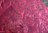
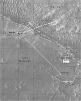
My take on the current Perseverance and Ingenuity maps:
|
I may try and register the heli color camera views as maps.
Posted by: kymani76 Jul 16 2021, 09:05 PM
|
Sol 137 update, color version.
Posted by: Phil Stooke Jul 26 2021, 03:53 AM
I was not expecting a drive but we had one on sol 153, about 100 m south. This presumably continues the quick run around the area to characterize it before selecting final sample sites.
Phil

|
Posted by: Phil Stooke Jul 28 2021, 11:41 PM
Sol 155, another drive.
Phil

|
Posted by: Bill Harris Jul 30 2021, 01:15 AM
..
Posted by: Phil Stooke Jul 30 2021, 03:40 PM
Sol 157, a short drive to the southeast to put the rocks in the workspace.
Phil

|
Posted by: kymani76 Aug 1 2021, 10:54 AM
Sol 157 update. For Ingenuity I'm using JPL's track, although I've seen other solutions.
|
Posted by: Phil Stooke Aug 11 2021, 07:01 AM
Map update to sol 168 - very rough as we don't have a full panorama or an updated map on the website yet.
Phil

|
Posted by: vjkane Aug 11 2021, 01:45 PM
Phil
|
|
I had expected Percy's team to keep it in place while they worked on the sampling problem. Apparently not.
Posted by: Bill Harris Aug 11 2021, 09:52 PM
Moving on, it's likely an unusual situation that they'll resolve by drilling and taking another core sample. There is probably nothing to be gained by sitting around and head-scratching. We'll have an interesting Core#1 to open in a few years.
--Bill
Posted by: PaulH51 Aug 11 2021, 10:12 PM
removed (wrong thread)
Posted by: Phil Stooke Aug 12 2021, 02:47 AM
Sol 169, with a corrected path for 168. "We'll have an interesting Core#1 to open in a few years" - no, that one will never be returned, it would take the place of a core packed with science so we'll have to wait until the Jezero Museum opens its doors.
Phil

|
Posted by: Phil Stooke Aug 12 2021, 08:32 PM
sol 170 map update - moving fast towards Seitah South.
Phil

|
Posted by: xflare Aug 13 2021, 07:59 AM
Hot tall are some of those dunes?
Posted by: PaulH51 Aug 19 2021, 05:53 AM
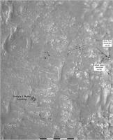
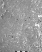
Seeing how Phil is away.
Here's a screenshot of the interactive map for sol 175 with a few annotations.
|
Posted by: Andreas Plesch Aug 20 2021, 12:38 AM
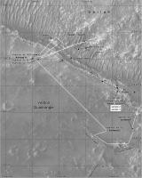
Here is a large map, showing the both the location of Perseverance and Ingenuity. Hopefully, I will have now some time to improve those (by labels, and mapping aerial views), although more deadlines are coming up.

|
Posted by: Andreas Plesch Aug 20 2021, 12:54 AM
And here a very large map of the rover's journey, with surroundings. There will be jpg artefacts due to very high compression:
https://user-images.githubusercontent.com/6171115/130161729-f28bbaad-518f-45f8-be39-0346e15feafa.jpg
(Click on the top or bottom margins for the high resolution version)

|
Posted by: Andreas Plesch Aug 20 2021, 01:03 AM
Based on the topographic contours on the map, some intermediate sized ones are 0.5m to 1m tall.
Posted by: Phil Stooke Aug 20 2021, 06:05 PM
I have updated my map to include drives to sol 177 and the corrected Ingenuity flight path. We just passed the 2000 m point on the drive and I will add a marker next time.
Phil

|
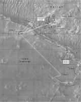
Posted by: Andreas Plesch Aug 20 2021, 11:37 PM
My take on sol177. I added cumulative travel distance for the rover, and per leg flight distances.
|
Posted by: Phil Stooke Aug 21 2021, 11:35 PM
A new map tile for sol 178, and this map covers the recent flights by Ingenuity as well. The last flight route is estimated using an analysis here:
https://twitter.com/65dbNoise/status/1429093549929283585
except that I think the landing point is wrong in that map.
Phil
|
Posted by: Phil Stooke Aug 21 2021, 11:52 PM
And here are two maps giving the names of Supercam targets up to sol 90 from the new PDS release.
Phil
|

|
Posted by: Phil Stooke Aug 23 2021, 03:21 AM
Sol 180 - moving a short distance to reach the target at Citadelle.
Phil

|
Posted by: Andreas Plesch Aug 24 2021, 01:58 AM
A new map along "Artuby" ridge, with sol180 updates, and better mapped path for flight 12 using the navigation images. Unfortunately, the first leg is poorly constrained sofar.

|
Posted by: Phil Stooke Aug 24 2021, 03:54 AM
An earlier map updated with the new name given in the rover update - as suggested by Paul. I'm always on the lookout for names to add to the map. This map also shows the name Artuby referring to the ridge, not a specific point on it.
Phil

|
Posted by: serpens Aug 26 2021, 10:58 PM
Mod,
Rimfax discussion not really appropriate for the route map thread. Could it be moved to another thread or even one dedicated to Rimfax?
ADMIN: Done. Moved to new http://www.unmannedspaceflight.com/index.php?showtopic=8650.
Posted by: Phil Stooke Sep 5 2021, 06:45 AM
Sol 193, Ingenuity made its 13th flight out across Seitah and back. I don't know the path yet but the early images show where it landed, back in Airfield H.
Phil

|
Posted by: Phil Stooke Sep 7 2021, 05:58 PM
I have been plotting the helicopter color images on the map - the position of the foreground in each suggests that some paths need to be modified. We often get the plan, not the actual path.
Stereo pairs are combined into a single outline in this version.
Phil

|
Posted by: Phil Stooke Sep 8 2021, 06:35 AM
Same for flight 9 on the previous map section.
Phil

|
Posted by: Bill Harris Sep 8 2021, 08:30 PM
So the three-sided figures are the FOV of the camera. It is interesting that the camera view angle is not always normal to the helicopter flight path. Since the camera is fixed to the fuselage this means that the helicopter is able to fly with the with the fuselage at any angle to the flight path. Not surprising, since this is within the capability of the cyclic pitch rotor control. But it also means that the navigation software is able to pick and follow features moving at an angle to the camera axis.
Very interesting capabilities of this helicopter system.
--Bill
Posted by: Phil Stooke Sep 9 2021, 02:31 AM
These are the large color camera images, not the small and much more numerous navigation images.
Phil
Posted by: Bill Harris Sep 9 2021, 03:21 PM
So you said. But the Color and Nav cameras are fixed and it follows that both cameras are seeing non-axial motion. It is interesting that Ingenuity does not have to invariably fly nose-forward.
On my demo co-axial I fly nose-forward because that is how I am programmed. But I can shift the camera view in x- and y- if I need to.
--Bill
Posted by: djellison Sep 9 2021, 06:31 PM
It's the Nav cam that used for visual odometry / feature tracking etc during flight - not the color RTE camera.
I'm not sure why non 'forward' motion is of note? The Nav cam is pointed straight down. ALL motion is 'at an angle to the camera axis.'
It basically works like a giant optical mouse.
I can't see how or why it would care which direction it's travelling.
Posted by: Phil Stooke Sep 11 2021, 08:58 PM
Map update to sol 199. The name Artuby is confirmed as applying to the whole ridge. I still don't have a path for the last Ingenuity flight.
Phil

|
Posted by: PaulH51 Sep 11 2021, 11:54 PM
'Phil Stooke' ... I still don't have a path for the last Ingenuity flight...
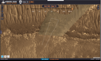
I don't know where they get their data, but RICE CRC have this for flight 13 https://perseverancerover.spatialstudieslab.org/?page=page_0&views=view_38%2Cview_55%2Cview_53%2Cview_13%2Cview_24%2Cview_47
|
Posted by: djellison Sep 12 2021, 12:51 AM
I believe they recreate a flight path using the Navcam images from the chopper.
Posted by: Phil Stooke Sep 12 2021, 02:09 AM
Thanks - I was just in the process of creating my own version with the DTE images:
|
The path Paul posted fits this very closely.
Phil
Posted by: Phil Stooke Sep 12 2021, 05:47 PM
Sol 200 - a very long drive, about 160 or 170 m, a record for Perseverance and longer than any drive by Curiosity.
Phil

|
Posted by: PaulH51 Sep 12 2021, 07:12 PM
Geojson reports the drive as: 169.854551 meters

Posted by: Phil Stooke Sep 13 2021, 05:23 PM
Sol 201, a shorter drive down the slope.
Phil
|
Posted by: Phil Stooke Sep 15 2021, 02:50 AM
Out into the sandy wilds of South Seitah. Or if you prefer, Seitah South.
Phil

|
Posted by: Phil Stooke Sep 15 2021, 09:46 PM
Sol 203, approaching the rocky hill.
Phil

|
Posted by: Phil Stooke Sep 17 2021, 07:33 AM
Sol 204. This might be the next drill site - if it passes its medical.
Phil

|
Posted by: Phil Stooke Sep 22 2021, 08:41 PM
Well, it didn't pass its medical by the look of it. Sol 210, another drive. The single front Hazcam image we have is enough to give a location but the path I show is just a guess until I know more.
Phil
|
Posted by: serpens Sep 26 2021, 06:43 AM
Your dedication to mapping is much appreciated Phil.
Posted by: Bill Harris Oct 2 2021, 04:44 PM
Is Perseverance parked in her Conjunction parking space since Sol 210?
Posted by: Phil Stooke Oct 2 2021, 06:51 PM
Yes - no more moves for a while.
Phil
Posted by: Phil Stooke Oct 7 2021, 06:05 PM
Here is the first map of my sequence with the new names i have been able to track down, thanks to help from Paul and Mike.
Phil

|
Posted by: Phil Stooke Oct 7 2021, 08:59 PM
Zoom into the landing site with new names. I don't know the story behind the 'Daren Lee Memorial' but Lee seems to have been a former JPL robotics engineer. The name comes from here:
https://sketchfab.com/cdt59#
(Thanks to Paul for the tip)
Phil

|
Posted by: Phil Stooke Oct 13 2021, 08:56 PM
Here is an update of the current map showing names I have gathered recently.
Phil

|
Posted by: Phil Stooke Oct 21 2021, 06:52 AM
New drive, new map. This is for sol 237 with a drive towards the next sampling area.
Phil

|
Posted by: Phil Stooke Oct 22 2021, 02:12 AM
We had a drive up to the outcrop on sol 238. This site is on the other side of the ridge called Martre from the last abrasion at Bastide.
Phil
|
Posted by: Phil Stooke Oct 23 2021, 07:20 AM
A small adjustment to the position on sol 239. Perseverance is now sitting at the base of the outcrop imaged on sol 238 (before the sol 238 drive, so at the sol 237 location) and shown here by Tau. But the rover is facing away from the outcrop at the moment.
Phil
|
Posted by: Phil Stooke Nov 7 2021, 12:14 AM
I have added Ingenuity's flight 15. It landed a little north of the targeted site. I am assuming it will be called Airfield F again.
Phil
|
Posted by: Phil Stooke Dec 1 2021, 12:06 AM
I have added Supercam names from PDS to one of the earlier maps. I will update others as I can get to them.
Phil
|
Posted by: Phil Stooke Dec 1 2021, 12:40 AM
Another of these updated maps.
Phil

|
Posted by: Phil Stooke Dec 3 2021, 08:54 PM
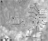
A zoomed in map of the sampling area at Brac.
Phil
|
Posted by: Phil Stooke Dec 3 2021, 09:17 PM
Perseverance has started its return journey to the landing site (presumably), and to reduce clutter and confusion in the maps I will make a separate map for the return journey, both for the rover and for Ingenuity. This map is updated to sol 279 for the rover and omits the last two return flights of Ingenuity. The next map will follow both of them.
I modified the straight line flight of Ingenuity on sol 163 based on my own mapping of Ingenuity images, but I may have exaggerated the kinks in the path. That might be partially straightened after I have thought about it a bit more.
Phil
|
Posted by: Phil Stooke Dec 4 2021, 12:29 AM
Return journey map for sol 280.
Phil

|
Posted by: Phil Stooke Dec 4 2021, 11:10 PM
Another drive on sol 281, on the way out of Seitah.
Phil
|
Posted by: Phil Stooke Dec 6 2021, 10:59 PM
A small move on sol 283, presumably setting us up for a study of some interesting target, maybe the sand ripple.
Phil

|
Posted by: Cherurbino Dec 7 2021, 03:01 AM
Phil, I'm sorry for presenting the table in this manner: this forum has no BBcodes for displaying tables copyable as text.
The forum engine also didn't allow me to attach the *.geojson file which was used as the data source. Its download link at NASA site (mission map nicknamed 'Where is the rover') is uncopiable - but to explain in words, it is available in the hidden 'Export to JSON' under the 'hamburger' button at top left.
I built this table in Excel to verify the flight lengths displayed in the https://mars.nasa.gov/technology/helicopter/#Flight-Log (column "f.log") with the calculations based upon areocoordinates and the so-called "northings" / "eastings" (column "calc") which I treat as offset from equator / zero meridian in metres.
Flights marked with the asterisk (*) are hops, roundtrips and other multileg 'brackets' where data is not comparable by default: the object of my investigation are straight routes where "f.log" must be equal to "calc".
Flight f.log calc northing easting N E
1* 0 0,05 1093314 4354502 18.44486 77.45102
2* 4 0 1093314 4354502 18.44486 77.45102
3* 100 0,76 1093314 4354502 18.44486 77.45102
4* 266 6,1 1093313 4354501 18.44486 77.45101
5 129 130,81 1093313 4354507 18.44486 77.45112
6* 215 100,75 1093183 4354522 18.44267 77.45139
7 106 106,3 1093124 4354441 18.44166 77.44994
8 160 160,48 1093018 4354453 18.43988 77.45015
9 625 620,33 1092862 4354489 18.43724 77.45079
10* 233 97,51 1092319 4354188 18.42808 77.44545
11 383 388,24 1092319 4354091 18.42808 77.44545
12* 450 26,19 1092590 4353813 18.43266 77.43878
13* 210 12,14 1092592 4353840 18.43269 77.43924
14 2 1,53 1092603 4353834 18.43287 77.43915
15 407 410,51 1092602 4353836 18.43286 77.43917
The ratio "reported / calculated" for the straight flights shows the tendency of undervaluation (5 cases from 6); the average is 0.9943 or minus 0.57%
5 0.9861631374
7 0.9971777987
8 0.9970089731
9 1.0075282511
11 0.9865031939
15 0.9914496602
One data entry in NASA's json is corrupt: the same coordinates are shown for fligts 10 and 11. Actually while the N value seems to be close to equal, the E values must differ (see airfields F and G).
Question 1: what figures for these airfields you use in your maps?
Question 2: is there any hope for the total recalculation of these waypoints after helicopter shall return (approximately) to its starting point at Wright Brothers a/f when figures shall explicitly show all errors in previously calculated coordinates / flight lengths accumulated in this 'dead reckoning'?
p.s. I shall be grateful if anybody posts here the direct link to the full set of four json files of waypoints/paths for Perceverance / Ingenuity. Thank you.
Posted by: Phil Stooke Dec 7 2021, 04:52 AM
I don't use any figures for my airfield locations. I plot them on the HiRISE base image by matching the features seen in the Navigation Camera descent images - the last few images of every flight, usually the first to be transmitted. My locations are relative to the base image, not to any coordinates. In an ideal case they would be the same.
Phil
Posted by: Cherurbino Dec 9 2021, 07:59 AM
Phil
Thank you, Phil. And here is the pilot version of my new chart: absolute elevations of helidromes from JZRO (Wright Brothers Field) through H with maximum flight levels' versus the start airfields.
Link to the full-size 1,000×688 image https://upload.wikimedia.org/wikipedia/commons/c/c1/Absolute_elevations_of_helidromes_and_max_flight_levels_of_Ingenuity.png. The file is really small (37.017 bytes). Source data credits to NASA/JPL are already written. File is uploaded to Wikipedia Commons under Creative Commons Attribution-Share Alike 4.0 International license.
Adding new flights and further improvement of the chart is supposed

|
Posted by: Phil Stooke Dec 9 2021, 07:57 PM
Map update to sol 285, with the name I misread is Gras corrected to Bras (the original source was too small to read clearly), and two names at the sol 285 location found By Paul. Thanks to all who contribute to this effort.
Phil
|
Posted by: kymani76 Dec 20 2021, 08:29 PM
|
Sol 286 map update. As I haven't updated my maps in a while, the whole traverse from sol 1 is shown.
Posted by: kymani76 Jan 4 2022, 07:04 PM
|
Sol 292 update, showing all sample sites to date.
Posted by: Bill Harris Jan 5 2022, 12:31 AM
Thanks for the updates!
--Bill
Posted by: kymani76 Jan 15 2022, 08:16 PM
|
Sol 322 update. Still no movement, but plenty of activity, which gives me opportunity to post detailed map of the last two sampling areas (Brac and Issole).
And thank you Phil for your input and interest.
Posted by: kymani76 Jan 23 2022, 08:30 PM
|
Short 4.3m drive marks Perserverance's first movement in a while.
Posted by: kymani76 Jan 30 2022, 09:29 AM
|
Sol 335 map update. Moving to the other side of the ridge.
Posted by: kymani76 Feb 4 2022, 08:03 AM

|
Sol 340 map update. Perseverance drove away from Issole outcrop after taking the 8th sample (?).
Now moving towards Artuby ridge and a target named Rimplas (location estimated).
Posted by: kymani76 Feb 7 2022, 10:47 AM
|
Sol 342, moving fast.
Posted by: kymani76 Feb 8 2022, 08:07 AM
|
Sol 343 update. Just a short drive to the east, crossing to the south side of Artuby ridge.
Posted by: kymani76 Feb 9 2022, 07:44 AM
|
Ingenuity flight 19 map. A short 62m hop designed to escape sand pool and land at Airfield E.
Posted by: Cherurbino Feb 12 2022, 07:02 AM
Hi, everybody! Please excuse me for the question that seems strange even to myself but anyway I must ask it.
Is this screenshot a fake, or I don't know some entries in the "Where is the rover" map/JSON service at https://mars.nasa.gov/maps/location/?mission=M20 ?
The fact is, that up to this time (06:45 GMT) the map still returns the position for Perseverance's sol 343, and the last entry in Ingenuity's JSON is for sol 292 / flight 18:
{"sol":292,"name":"HELI pos18","easting":4354450.039,"northing":1092802.59,"elev_geoid":-2572.994,"lon":77.45010229,"lat":18.43624068},"geometry":{"type":"Point","coordinates":[77.450102,18.436241,-2572.994]}}
The scecial point of my concern is the label "Flight: 19". I tried all the settings in the left sidebar called with a 'hamburger' icon, but all the attempts to invoke this type of label (like labels "sol" and "length") failed.
Another screenshot from the same source:
Note zero values for 'Distance driven' in the header line. However the location of the blue helicopter sign seems close to the actual landing spot of flight 19.
Thank you,
- Cherurbino.
Posted by: Phil Stooke Feb 12 2022, 07:59 AM
Not fake. I just reproduced it myself. Display the map and then move the cursor to the location of one of the dots representing waypoints along the route. The dark box with white text will appear to tell you which point you are pointing at (e.g. sol 130 for the point just south of your label). Move to a point between dots and you get the drive length. They have added Flight 19 as a pop-up label if you move the cursor close to that location even if the helicopter path is not displayed.
Phil
Posted by: Cherurbino Feb 12 2022, 01:13 PM
Phil
I could not repeat your experiment.
1. Re: 'dots representing waypoints along the route' - there's still no (yellow) dot representing 'flight 19' on Ingenuity's route. Available are: sol 120 to the north and sol 292 at the bottom of the blue 'raindrop' icon of the helicopter which represents the landing after flight 18.
2. Re: 'e.g. sol 130' in your sample is the sol of Perseverance - I caught this position at my screenshot which includes the coordinates of the cursor location. I searched everything within the triangle 'sol 120 (I) - sol 130 (P) - sol 292 (I)', but no 'Flight' labels popped up.
Could you screenshot your experiment to make the 'Flight' label visible along with the 'coordinates' string in the footer? (I shall try to find it by these figures). To make your resulting screenshot smaller it's a good idea to shrink the frame by cursor-resizing its borders and then click Alt+Printscreen to capture only the current window instead of the entire screen.
|
Posted by: mcaplinger Feb 12 2022, 09:55 PM
It's a little hard to tell what you're asking, but if you export the heli location to GeoJSON you get
"type": "FeatureCollection",
"features": [
{"type":"Feature","properties":{"flight":19,"SF3_X":-447.7,"SF3_Y":-7.25,"SF3_Z":-0.51,"easting":4354486.836,"northing":1092851.995,"elev_geoid":-2569.4,"lon":77.45075678,"lat":18.43707418},"geometry":{"type":"Point","coordinates":[77.450757,18.437074,-2569.4]}}
]
}
which seems like the post-flight-19 location?
Posted by: Phil Stooke Feb 13 2022, 03:11 AM
I replied to Cherurbino privately but the solution to the problem may be of interest so I will mention it here. The online map behaves differently depending on the browser being used (I didn't think to check operating systems but I suppose that might also be an issue). If it doesn't do what you expect, try another browser. Cherurbino thought this whole exchange should be removed, but it might be useful to keep it as a record of the issue.
Phil
Posted by: Cherurbino Feb 14 2022, 12:19 AM
"type": "FeatureCollection",
"features": [
{"type":"Feature","properties":{"flight":19,"SF3_X":-447.7,"SF3_Y":-7.25,"SF3_Z":-0.51,"easting":4354486.836,"northing":1092851.995,"elev_geoid":-2569.4,"lon":77.45075678,"lat":18.43707418},"geometry":{"type":"Point","coordinates":[77.450757,18.437074,-2569.4]}}
]
}
which seems like the post-flight-19 location?
The issue was that the last line in JSON obtained by me on on February 12 (the 'Export to JSON' button) related to the Flight 18, not 19th.
Also note the difference in syntax between our snippets:
{"sol":292,"name":"HELI pos18","easting":4354450.039,"northing":1092802.59,"elev_geoid":-2572.994,"lon":77.45010229,"lat":18.43624068},"geometry":{"type":"Point","coordinates":[77.450102,18.436241,-2572.994]}}
Today (February 13) all browsers return data for Flight 19 in m20_heli_waypoints.json. Thus it remains to wait for Flight 20 to repeat with browsers' experiments.
-------
Phil Stooke:
Right you are, Phil. The OS may be involved indirectly, setting the minimal build version allowed for updrading the browser's engine version. Say, if one runs the old computer where max OS is Windows XP, then his browser shall not allow to upgrade its Mozilla engine with the build higher than XX.YY.ZZZZ". His browser shall continue to process the Web pages however some 'innovative' functions on them shall be ignored.
Thus, the only solution for that poor user is to upgrade the whole chain: buy the modern computer, install the last OS, which opens the way to upgrade the browser and the build of its version.
Posted by: kymani76 Feb 16 2022, 12:47 PM
|
Sol 352 update, a long drive around corner of Seitah, no re-sampling at Roubion.
EDIT: I replaced the map with new version, with scale bar fixed.
Posted by: charborob Feb 16 2022, 02:10 PM
I think the scale bar in the upper left of your map is incorrect, if I compare your map to the Perseverance Location Map (https://mars.nasa.gov/mars2020/mission/where-is-the-rover/. What is the size of the grid on your map?
Posted by: kymani76 Feb 16 2022, 02:30 PM
I temporarily put the map in geographical projection instead of equirectangular to to some work and forgot to switch back, that's why the scale bar was off.
I reposted the fixed version above.
The grid is 100x100 meters, the same applies to Curiosity and Zhurong traverse maps.
Thank you for spotting it.
Posted by: kymani76 Feb 17 2022, 12:07 PM
|
Sol 353, drive about 212.4 meters long. They added so called mid-drive locations to the rover's geojson data, which are marked as half-circles on the map.
Posted by: kymani76 Feb 17 2022, 10:35 PM
|
Sol 354 update.
Posted by: kymani76 Feb 19 2022, 11:44 AM
|
Sol 355, we are almost back to the landing site.
Posted by: kymani76 Feb 25 2022, 03:52 PM
|
Map update for the last couple of sols.
Posted by: Cherurbino Feb 28 2022, 09:45 AM
Hi everybody, hi Phil!
A year ago Phil started this thread with a blank map.
The new campaign stage shall start as soon as Perseverance shall take its last sample(s) from the Chał rock type. Another expected event shall come when at mid March the pressure shall grow as much as it allows Ingenuity to return to the normal rpm's (and 190 sec flight duration) which in its turn shall allow it to perform a non-stop flight over Seitah - now in NW direction (see https://mars.nasa.gov/news/9134/ and status reports).
To estimate the possibility of such a long flight an elevation map is necessary. The lower the arrival field is, longer the distance may be covered, as it already happened in Flight #9. My question / request is:
- where the elevation map of this region (see attachment) may be obtained, or
- can anybody publish such a map here?
--Cherurbino
|
Posted by: fredk Feb 28 2022, 03:58 PM
Check out the landing thread, eg http://www.unmannedspaceflight.com/index.php?showtopic=8591&st=90&p=249830&#entry249830 or http://www.unmannedspaceflight.com/index.php?s=&showtopic=8591&view=findpost&p=249822
Posted by: kymani76 Mar 1 2022, 04:11 PM
|
Sol 362 update.
Posted by: kymani76 Mar 1 2022, 04:27 PM

|
Very quick solution for the elevation map query with two versions of future traverse path. I hope it helps.
Posted by: mcaplinger Mar 1 2022, 05:23 PM
That's a beautiful product!
BTW, I find it hard to believe that this amount of topographic variation is going to make a big difference to the helicopter. Much more significant is the seasonal global variation in pressure.
Posted by: kymani76 Mar 1 2022, 05:40 PM
Thank you very much. Yes it's pretty much flat all the way to the delta.
Posted by: kymani76 Mar 2 2022, 12:05 AM

|
Flight 20 map. Ingenuity landed in a sand pool again.

|
Perspective view of the new landing site.
Posted by: Cherurbino Mar 2 2022, 07:58 PM
Very quick solution for the elevation map query with two versions of future traverse path. I hope it helps.
Thank you, fredk; thank you kymani76!
-- Cherurbino
Posted by: Cherurbino Mar 3 2022, 02:12 AM
Very quick solution for the elevation map query with two versions of future traverse path. I hope it helps.
kymani76, your map displays only one version: helicopter accompanies rover in its «https://en.wikipedia.org/wiki/It's_a_Long_Way_to_Tipperary»
, i.e. NE to the western rim of 'La Orotava' crater, then CCW around the easternmost 'gulf' of Séítah and then straight W up to the 'Three Forks'.Meanwhile on February 23, 2022 Jaakko Karras in his https://mars.nasa.gov/technology/helicopter/status/366/
Can anybody clarify which of these alternatives for helicopter is actual now?
-- Cherurbino
Posted by: mcaplinger Mar 3 2022, 03:58 AM
I think that product shows two different possible rover routes and no helicopter route at all.
I see no reason to doubt Karras' summary of how they plan to fly.
Posted by: Cherurbino Mar 3 2022, 08:17 AM
I see no reason to doubt Karras' summary of how they plan to fly.
Thank you for clarification.
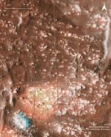
Posted by: tau Mar 4 2022, 03:02 PM
Regarding the planned helicopter and rover routes, it was written https://mars.nasa.gov/technology/helicopter/status/366/dusty-flight-19-completed-and-looking-ahead-to-flight-20/:
If the helicopter cannot fly nonstop across Séítah, a sandy area without large rocks might be suitable for a stopover.
On a live public talk in february 2022, the planned rover route was shown https://youtu.be/-IAcwLYYFGk?t=1318. It is the yellow line in the map below.
Numbers are elevation in meters. Thin contour lines every 1 meter.

|
Posted by: kymani76 Mar 4 2022, 07:58 PM

|
I found some time to further elaborate on this map, so here is the new result (with more compression than original to fit here)
I added probable flight azimuths for next flights of Ingenuity, but this is pure speculation on my part.
My estimate is that at least 3 flights will be needed to cross Seitáh.
Posted by: Cherurbino Mar 5 2022, 03:27 PM
Covering 632 m in Flight #9 was possible due to the fact that the helicopter was 'sliding down' from - 2569 at departure to -2579 at arrival.
On contrary, flight #21 M->N shall be climbing out of the -2570 'pit' up to... say, -2565 (=+5m), so I'm not sure that 'ordinary' ~400 m for 170 sec may be covered.
Next limitation is 1000 m for communications. Helicopter may wait for a long time at 'Field N', until Perseverance reappears at the northern side of Seitah region in a direct LOS view at a distance <1000 m.
-Cherurbino
Posted by: Phil Stooke Mar 8 2022, 04:20 AM
A couple more of my maps with extra names taken out of the PDS:

|
|
Phil
Posted by: kymani76 Mar 15 2022, 04:00 PM

|
Sol 375/Flight 21 map update.
Posted by: tau Mar 20 2022, 09:22 PM
If I'm not completely wrong when comparing Navcam and HiRISE images, the rover made a 200 m drive on sol 384.
The estimated coordinates are approximately 77.4620°E 18.4571°N
Green line: planned rover traverse
|
Posted by: kymani76 Mar 22 2022, 12:11 PM

|
|
Perseverance drive to sol 381 and latest update to sol 385.
Posted by: kymani76 Mar 22 2022, 12:13 PM
|
Sol 384, flight 22 map.
Posted by: kymani76 Mar 24 2022, 11:22 PM
|
|
Sols 386 & 388 map updates.
Posted by: kymani76 Mar 24 2022, 11:26 PM
|
|
|
|
Some synthetic vistas of the La Orotova crater that we unfortunately missed to see from up close.
Posted by: kymani76 Mar 27 2022, 08:29 AM
|
|
Sol 389 update for Perseverance and sol 388 / flight 23 for Ingenuity. We might see skycrane on the next flight.
Posted by: MarkL Mar 29 2022, 07:45 PM
|
|
|
|
Sol 389 update for Perseverance and sol 388 / flight 23 for Ingenuity. We might see skycrane on the next flight.
These are such great maps thank you. Nice to see the contour lines.
Posted by: kymani76 Mar 30 2022, 06:16 AM
Thank you Mark.
Here is a new version of flight 23 map, updated with latest the JPL track.
Ingenuity didn't fly in a straight line, but headed north first and then made sharp turn to the west. It means they are flying very close to the planned track.
|
Posted by: Bill Harris Mar 30 2022, 07:24 PM
I figured that.they would avoid flying over that hill.and stay in the flat area.
--Bill
Posted by: MarkL Mar 31 2022, 01:03 PM
--Bill
I think they. indicated a while back they were planning a dog leg around the hill Bill.
Also, they are commanding Ingenuity over distances exceeding 1 km without much difficulty it seems. I guess its just a matter of bitrate. Is there a practical maximum limit for the antennas where the bitrate drops below say a couple hundred baud?
Mark
Posted by: Ant103 Apr 8 2022, 11:16 AM
I never did that in the past, but a map of what I think is the last known location of the rover, using my last panorama :
|
Posted by: Keltos Apr 11 2022, 06:53 PM
Erin Gibbons, team member posted this for sol 405
|
Posted by: Cherurbino Apr 20 2022, 05:54 AM
Hi, everybody! Yesterday the new https://mars.nasa.gov/news/9170/ plan was published. May I ask anybody to draw the arrows for Cape Nukshak and Hawksbill Gap mentioned there? Thank you.
--Cherurbino
Posted by: Keltos Apr 20 2022, 09:49 AM
hi
Got the location from @dejasu and set them on the Uberlin Hirise map
Hope that helps
Fred
Map with contour lines : https://maps.planet.fu-berlin.de/jezero/
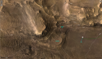
|
Posted by: PaulH51 Apr 20 2022, 11:36 AM
--Cherurbino
The initial sections of the two paths are shown in this document from a recent MEPAG meeting, refer to slide 9 of the presentation. The route names are in very small text: https://mepag.jpl.nasa.gov/meeting/2022-01/07_Karras_Tzanetos_MEPAG_20220202_Ingenuity.pdf
Posted by: kymani76 May 3 2022, 07:56 AM
I'm sorry but I had some earthly work that kept me away from Mars mapping, but finally found some time to update my maps.
I noted that they are tinkering a lot with a geojson (like renumbering sols), which made my work a bit more complex (to track all the changes).
I also reworked the distance grid as well to make it more precise (note its rectangular appearance, where latitude axis is shorter than longitude's)
So here it is, update to sol 426 for Perseverance and flight 28 for Ingenuity.
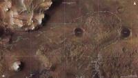
|
Posted by: kymani76 May 3 2022, 08:00 AM
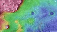
|
Elevation map.
Posted by: MarkL May 4 2022, 11:16 PM
I noted that they are tinkering a lot with a geojson (like renumbering sols), which made my work a bit more complex (to track all the changes).
I also reworked the distance grid as well to make it more precise (note its rectangular appearance, where latitude axis is shorter than longitude's)
So here it is, update to sol 426 for Perseverance and flight 28 for Ingenuity.
|
|
This is a hobby for most of us I think so the time you commit to making these great images away from your other paying work is very much appreciated.
Posted by: kymani76 May 18 2022, 08:48 AM
Thank you very much, positive feedback is what keeps me going.

|
An update to sol 439. I miss new target names, they are difficult to come by.
Posted by: Phil Stooke May 18 2022, 05:52 PM
While busy with other things I am still collecting names - but there have been very few lately. I don't know the exact locations yet for Rocky Top (probably off this map to the north) or Devils Tanyard.
(I will post from time to time...)
Phil

|
Posted by: kymani76 May 28 2022, 09:32 AM

|
Sol 449 map update, Perserverance straddling carefully along the edge. Thanks Phil for the names update.
Posted by: kymani76 May 28 2022, 09:34 AM

|
Map version with severity of slopes indicated.
Posted by: vjkane May 29 2022, 08:29 PM
|
|
Map version with severity of slopes indicated.
That map is a work of art. Thank you for creating it.
Posted by: kymani76 May 30 2022, 07:35 PM
Thank you, that is a really nice compliment. I also made a similar map for Curiosity, see the MSL map section.
Map incorporating all the new topography names reported by Phil earlier today.
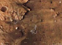
|

|
closeup of current location
Posted by: MarkL Jun 1 2022, 10:49 PM
Map incorporating all the new topography names reported by Phil earlier today.
...
Beautiful maps thank you. I hesitate to offer any suggestions, but would it be possible on future versions to use a finer traverse line and smaller triangles for the waypoints? Some areas (like the current location) are congested with waypoints.
Thanks again. Really enjoy poring over these!
Mark
Posted by: kymani76 Jun 7 2022, 08:51 AM

|
Thank you Mark. I constantly tweak the maps in one way or another in order to improve them. I gave your suggestion a try and made lines thinner and symbols a bit smaller, but at times it is still difficult to totally de-clutter the map.
I hope you like the new result.
I also managed to find a few target names in Perseverance's updates. The exact sols when these targets were focused on is not indicated, but there is suggestion of existence of additional names.
Posted by: MarkL Jun 7 2022, 10:30 PM
I hope you like the new result.
I also managed to find a few target names in Perseverance's updates. The exact sols when these targets were focused on is not indicated, but there is suggestion of existence of additional names.
Lovely. Thanks again for these wonderful immersive maps.
Posted by: Cherurbino Jun 13 2022, 12:36 PM
The new location map from https://fosstodon.org/@65dBnoise/108476947410723316
This message was updated after flight 29 -- Cherurbino

|

|
Posted by: kymani76 Jun 20 2022, 12:57 PM

|
Regular update of Perseverance's location, sol 464
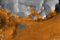
|
Map for flight 29, with terrain visible to Ingenuity highlighted in orange.
Posted by: Phil Stooke Jun 20 2022, 06:59 PM
This is what I have so far for names. I can't guarantee all of them are in the right location (e.g. Hughes River Gap).
Phil
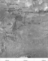
|
Posted by: Phil Stooke Jul 24 2022, 09:20 PM
Trying to keep up with names. Paul has helped by pointing some things out to me, much appreciated. I am now pulling names out of the Analysts notebook and will post more maps soon, but there were almost no names given along the rapid traverse around the top of Seitah.
Phil

|
Posted by: Phil Stooke Jul 25 2022, 12:16 AM
Two more maps with names in this area.
Phil

|
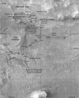
|
Posted by: Phil Stooke Jul 26 2022, 06:59 PM
This map goes back earlier with a few names from the drive north after the Seitah sampling.
A particularly significant point is the location labelled '350', the end of drive location on sol 350. That drive was not documented with the usual end of drive panorama and the location shows up as 351 on the mission map. The real 351 location is further along the path, and the map misleadingly suggests the '350' point is a waypoint along that drive. The text of the Analyst's notebook makes it clear there was a sol 350 drive and the raw Navcam images for sol 350 show stages along that drive. The rear Hazcams for the start of sol 351 show the same location before the 351 drive. So this 'stealth drive' has not been shown correctly on any map up to now.
Phil
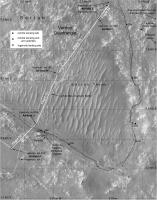
|
Posted by: djellison Jul 26 2022, 09:19 PM
I'm guessing that was a multi sol drive without ground in the loop.
Posted by: Phil Stooke Jul 27 2022, 04:49 PM
Yes, it was.
Posted by: Phil Stooke Jul 29 2022, 09:25 PM
Putting together some details from earlier in the mission. Here is a map of the Issole region showing the rover positions at the various stops arounmd the outcrop.
Phil
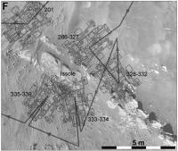
|
Posted by: Gladstoner Aug 27 2022, 01:55 AM
Moving back south:
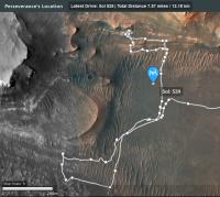
|
Posted by: Phil Stooke Aug 31 2022, 07:16 AM
Quick update to sol 543. I'm making maps to record names, and will post them from time to time. No, I don't really have time for this!
Next, the previous map of this area with names...
Phil
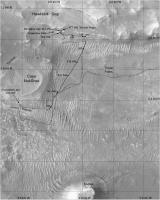
|
Posted by: Phil Stooke Sep 8 2022, 02:23 AM
Some recent maps I am using to document names and helicopter flights.
Phil
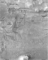
|
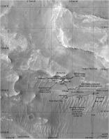
|
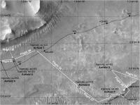
|
Posted by: john_s Sep 8 2022, 01:51 PM
Hi Phil-
Looks like a typo on the latest (and wonderful as always) Perseverance map- the "541-542" label is used in two locations.
John
Posted by: Phil Stooke Sep 8 2022, 03:41 PM
Oops - yes, should be 541 and 542 at the two points. I don't know where that came from. Will fix shortly.
Phil
Posted by: Phil Stooke Sep 9 2022, 07:10 AM
This is the corrected map. Good job I have an army of proof-readers out there! Corrections are always welcome.
Phil
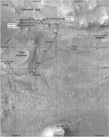
|
Posted by: PaulH51 Sep 12 2022, 11:02 PM
Screen captures of the interactive map: Shows the rover's position after the long drive during sol 555 (219.9 m / 721.47 ft) including an interesting diversion before crossing another TAR, it also shows the location of 'Enchanted Lake' about 20 meters northeast of the rover's sol 555 location. Also shown the helicopters position after flight 31 on sol 550 (97.7 m / 321 ft)
The calculated distance between the two craft is currently 857.7 m / 2814 ft. Communications between the craft remains good with 187 (flight 31) images received from the helicopter after the drive.
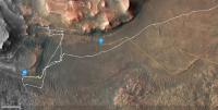
|
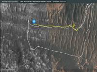
|
Posted by: tau Sep 18 2022, 10:20 AM
Here is a map of the eastern part of future potential traverse paths (white lines) for Perseverance.
Thick contour lines every 10 meters, thin lines every meter. Numbers are sols on the past traverse.
The future potential paths are digitized from the map shown at the https://youtu.be/9vZVcI1gwEU?t=1715 on 2022-09-15 .
|
Posted by: Bill Harris Sep 19 2022, 03:08 AM
"Screen captures of the interactive map: Shows the rover's position after the long drive during sol 555 (219.9 m / 721.47 ft) including..." (Paul)
Thanks Paul. Ingenuity has to be the Epic engineering story on Mars. I am astounded that she keeps going since she is a much lighter and simpler mechanism than the Rovers. I would have expected the batteries to have expired by now.
--Bill
Posted by: Bill Harris Sep 19 2022, 03:14 AM
"Here is a map of the eastern part of future potential traverse paths (white lines) for Perseverance..." (Tau)
That is a tremendous map format, and especially that it shows potential future paths.
--Bill
Posted by: Phil Stooke Sep 19 2022, 09:24 PM
Yes, it's a very nice map.
Here is a quick update to the present time showing the latest helicopter flight on sol 561 and a few names which Paul has been helping me track down.
Phil

|
Powered by Invision Power Board (http://www.invisionboard.com)
© Invision Power Services (http://www.invisionpower.com)