Cape York - Shoemaker Ridge and the NE traverse, Starting sol 2735 |

  |
Cape York - Shoemaker Ridge and the NE traverse, Starting sol 2735 |
 Oct 23 2011, 09:37 PM Oct 23 2011, 09:37 PM
Post
#211
|
|
|
Senior Member  Group: Members Posts: 2998 Joined: 30-October 04 Member No.: 105 |
QUOTE (MHoward) iPhone/iPod Touch with a my3D, the latter two images are compatible Nice, but be advised that these are not x-eyed stereo, and one can sproing one's eyes trying to view au naturel.  Easy cut-and-paste fix at home, though. --Bill -------------------- |
 |
 
|
|
Oct 23 2011, 10:46 PM
Post
#212
|
|
 Senior Member Group: Moderator Posts: 3431 Joined: 11-August 04 From: USA Member No.: 98 |
QUOTE (Bill Harris @ Oct 23 2011, 03:37 PM)  Easy cut-and-paste fix at home, though. What's the fix? I ask just for information purposes - I've never been able to view stereo pairs au naturel myself. |
|
|
|
|
Oct 24 2011, 12:03 AM
Post
#213
|
|
|
Senior Member Group: Members Posts: 2998 Joined: 30-October 04 Member No.: 105 |
Simple-- in an image editor, swap the images left-right. The "right channel" image needs to be on the left and and the "left channel" image needs to be on the right for "cross-eyed" viewing. It's an acquired habit and one that needs practice. And it helps to be nearsighted.
Most of the close-in Pancam stereo pairs need to be rotated and aligned because of the way the camera mast moves, and L257 and R721 images need to be color-matched, so you've done 90% of the work already. Thanks! --Bill -------------------- |
|
|
|
|
Oct 24 2011, 02:04 AM
Post
#214
|
||
|
Member Group: Members Posts: 808 Joined: 10-October 06 From: Maynard Mass USA Member No.: 1241 |
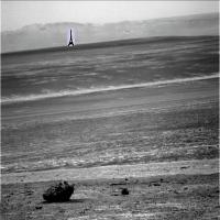
Here is my first crude attempt at putting the Eiffel Tower in Endeavour Crater
The Eiffel is almost exactly 1000 feet tall The crater is almost 14 miles across, so half way across is 7 miles or roughly 40K feet At that distance a 1000 foot object would appear 1.43 degrees tall. (right triangle math) Each Pancam pixel resolves 0.28 mrads 1.43 degrees is about 24 mrads So the tower would be about 80 pixels tall at 40,000 feet away. I found a silhouette online and shrunk it to 80 pixels. (please check my math....) I put the Eiffel on top of the center mound in the crater, thinking it represented about halfway across. (i didn't tilt the image to match the tower, so we have a leaning tower of eiffel...) Your mileage may vary...
-------------------- CLA CLL
|
|
|
|
|
|
|
Oct 24 2011, 03:15 AM
Post
#215
|
||
 Member Group: Members Posts: 404 Joined: 5-January 10 Member No.: 5161 |
The winds of Mars sandblast the rocks in such a way that uncanny projections stick way out at times, more so than we see on Earth. I would guess due to the weaker gravity. This new one is exceptionally top-heavy:
|
|
|
|
|
|
|
Oct 24 2011, 03:48 AM
Post
#216
|
|
 Senior Member Group: Admin Posts: 4763 Joined: 15-March 05 From: Glendale, AZ Member No.: 197 |
Its probably not so much lower gravity causing these unlikely balanced rocks as it is a lack of other forces acting on them on the plains of Meridiani. They sit there for millions of years with nothing but the slow steady erosion of wind and the gentle pull of gravity eroding ever so slowly in the same direction for eons. There is no frost heaving, nor snow melt, nor glaciers, nor any erosion caused by any water of any kind. There are no earthquakes, no land slides and very little mass-wasting in this region. No trees falling over, no animals stomping on them, no tree roots pushing up from under them. I'm guessing that we won't see as many balancing-egg structures in the steep canyons of Valles Marineris where landslides and slumping are more common or near the poles where the frosts come and go seasonally.
-------------------- If Occam had heard my theory, things would be very different now.
|
|
|
|
|
Oct 24 2011, 04:12 AM
Post
#217
|
|
 Senior Member Group: Members Posts: 2228 Joined: 1-December 04 From: Marble Falls, Texas, USA Member No.: 116 |
QUOTE (Stu @ Oct 22 2011, 10:06 AM) No vertical exaggeration at my end. I just took the anaglyph from this HiRISE page: ... A while back (actually, about 5 years ago) we had a discussion regarding vertical exaggeration in HiRise stereo pairs. The geometry is fairly straightforward and the HiRise site provides the required information about the viewing angles from which the angular separation between the images can be determined. I posted an Excel spreadsheet back then which calculates the vertical exaggeration for a defined image pair based on the distance between your eyes and your monitor. If you are comfortable with editing spreadsheets, you can use this one to calculate the vertical exaggeration inherent in the pair of images used in an anaglyph, if you know which HiRise images were used. -------------------- ...Tom
I'm not a Space Fan, I'm a Space Exploration Enthusiast. |
|
|
|
|
Oct 24 2011, 08:08 AM
Post
#218
|
|
|
Senior Member Group: Members Posts: 2998 Joined: 30-October 04 Member No.: 105 |
Just snagged yesterday's 18:35 data upload. No new Pancam morsels but we have a new 360 deg Navcam pan, which is always great for context and circular pans. Looks like Oppy is continuing to tiptoe along the ridgetop towards "winterhaven" with the light-toned (reddish, actually) wind-deflated area to the right (east) and the rippled, net-deposition area in the wind shadow to the left (west).
--Bill -------------------- |
|
|
|
|
Oct 24 2011, 08:35 AM
Post
#219
|
|
|
Senior Member Group: Moderator Posts: 4279 Joined: 19-April 05 From: .br at .es Member No.: 253 |
According to the "telemetry", this last drive moved the rover left of the ridgetop. I will provide a map update later on.
|
|
|
|
|
Oct 24 2011, 08:59 AM
Post
#220
|
|
|
Senior Member Group: Members Posts: 2998 Joined: 30-October 04 Member No.: 105 |
...but we've been moving along the west (left) side of the ridgetop since we hit Shoemaker Ridge. The heading will change more northward, in the direction of "winterhaven".
--Bill -------------------- |
|
|
|
|
Oct 24 2011, 10:03 AM
Post
#221
|
||
 The Poet Dude Group: Moderator Posts: 5551 Joined: 15-March 04 From: Kendal, Cumbria, UK Member No.: 60 |
3D view of latest panorama... loving those hills...
http://twitpic.com/752kts Crop of faraway hills...
-------------------- |
|
|
|
|
|
| Guest_Oersted_* |
Oct 24 2011, 11:46 AM
Post
#222
|
|
Guests |
QUOTE (PDP8E @ Oct 24 2011, 04:04 AM) Here is my first crude attempt at putting the Eiffel Tower in Endeavour Crater Crude yes, but a good first attempt! If you got the size right, then this is actually the first image that really tells me, viscerally, how big Endeavour is. Now it would be good to plop the Eiffel Tower down in an image with a zoom-factor of around 50mm, which approximates that of the human eye. I just finished Bill Bryson's Australia book "Down Under" on the plane today, and came across this: "Uluru is not merely a very splendid and mighty monolith, but also an extremely distinctive one. More than this, it is very possibly the most immediately recognizable natural object on earth. I'm suggesting nothing here, but I will say that if you were an intergalactic traveller who had broken down in our solar system, the obvious directions to rescuers would be: 'Go to the third planet and fly around till you see the big red rock. You can't miss it.'" - Well, since I walked around Ayer's Rock one enchanted January day this year, I have to agree with Bryson. I and my sore footsoles have a really good feel for how big it is, so that geological wonder would be another good size indicator for me at least... |
|
|
|
|
Oct 24 2011, 12:28 PM
Post
#223
|
|||
|
The Poet Dude Group: Moderator Posts: 5551 Joined: 15-March 04 From: Kendal, Cumbria, UK Member No.: 60 |
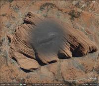
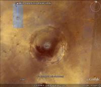
Now I couldn't resist giving that a go...!
1) Uluru vs Cape York...
2) Uluru vs Endeavour Crater...
Fascinating! (and a great idea for a blog post, thanks!  ) )
-------------------- |
||
|
|
|
||
|
Oct 24 2011, 03:06 PM
Post
#224
|
||
|
Senior Member Group: Moderator Posts: 3431 Joined: 11-August 04 From: USA Member No.: 98 |
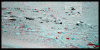
360x90 anaglyph Navcam panorama centered on north for sol 2754
Attached thumbnail(s)
|
|
|
|
|
|
| Guest_Oersted_* |
Oct 24 2011, 03:30 PM
Post
#225
|
|
Guests |
QUOTE (Stu @ Oct 24 2011, 02:28 PM) Now I couldn't resist giving that a go...! 1) Uluru vs Cape York... 2) Uluru vs Endeavour Crater... Fascinating! (and a great idea for a blog post, thanks! )You're welcome! - Soeren Ok, walking around Uluru was a leisurely 4-hour walk, so Cape York wouldn't take much more than half an hour. As for Endeavour Crater.... Wowsers! Even bigger than I thought: it is positively humongous... Now for those perspective views in images taken at a focal length of 50mm... (And sorry for not doing them myself, but I am sitting at work computers with nothing more than "Paint" on them...) |
|
|
|
|

|
Lo-Fi Version | Time is now: 20th April 2024 - 12:47 AM |
|
RULES AND GUIDELINES Please read the Forum Rules and Guidelines before posting. IMAGE COPYRIGHT |
OPINIONS AND MODERATION Opinions expressed on UnmannedSpaceflight.com are those of the individual posters and do not necessarily reflect the opinions of UnmannedSpaceflight.com or The Planetary Society. The all-volunteer UnmannedSpaceflight.com moderation team is wholly independent of The Planetary Society. The Planetary Society has no influence over decisions made by the UnmannedSpaceflight.com moderators. |
SUPPORT THE FORUM Unmannedspaceflight.com is funded by the Planetary Society. Please consider supporting our work and many other projects by donating to the Society or becoming a member. |
|