Endeavour Drive - Drivability analysis |

  |
Endeavour Drive - Drivability analysis |
 Oct 9 2008, 04:10 PM Oct 9 2008, 04:10 PM
Post
#541
|
|
 Senior Member  Group: Moderator Posts: 2785 Joined: 10-November 06 From: Pasadena, CA Member No.: 1345 |
Thank you Paolo!
The last few weeks have been an absolute blast. Seeing the efforts put into building terrain models, proposing routes, and the back and forth discussion and movement of data and analysis products happening with members around the planet has been truly inspiring. Your helpful comments and challenges have spurred UMSF to a new level. I completely agree with Geert's comments - now that we've started this analysis, it makes perfect sense to continue. We may no longer have benefit of your input, but the products of our efforts will still be available for anyone interested. (And on a personal level, I know I'll start following Oppy's progress towards Endeavour much more closely, no matter what path is chosen!) -Mike -------------------- Some higher resolution images available at my photostream: http://www.flickr.com/photos/31678681@N07/
|
 |
 
|
|
Oct 9 2008, 04:18 PM
Post
#542
|
|
 The Poet Dude Group: Moderator Posts: 5551 Joined: 15-March 04 From: Kendal, Cumbria, UK Member No.: 60 |
... and come on, as if we're going to stop now... of course we'll just carry on, if only to see how closely our chosen path follows the path eventually taken to Endeavour!
 (of course, when I say "we" I mean "those forum members who have the knowledge and expertise to do all this incredible stuff"... I'm just happy to sit back and watch you all )
-------------------- |
|
|
|
|
Oct 9 2008, 06:06 PM
Post
#543
|
|
|
Senior Member Group: Members Posts: 2917 Joined: 14-February 06 From: Very close to the Pyrénées Mountains (France) Member No.: 682 |
Come on Stu, I'm sure you're not going to let the "technicians" (no offense
) "choose" Oppy's route without giving your own opinion.
-------------------- |
|
|
|
|
Oct 9 2008, 06:29 PM
Post
#544
|
|
|
The Poet Dude Group: Moderator Posts: 5551 Joined: 15-March 04 From: Kendal, Cumbria, UK Member No.: 60 |
Yep, I am. I'm just a passenger on this ride. I am more than happy to trust the choice of route to people with the right experience and tech and software, leaving me to make pretty pictures of the scenery along the way. I know my limits.
-------------------- |
|
|
|
| Guest_Oersted_* |
Oct 9 2008, 07:38 PM
Post
#545
|
|
Guests |
OK I guess the JPL management leaves us no other choice. Let's open a new thread about uploading driving commands and hacking into the DSN....
 Grazie mille per averci lasciato accompagnarti un po' durante l'avventura! Non c'e amarezza da questa parte, soltanto gioia per aver potuto avere un contatto un po' piu stretto con te e gli altri nostri eroi della squadra MER. Buon proseguimento, stiamo con voi! |
|
|
|
|
Oct 10 2008, 01:42 AM
Post
#546
|
||
|
Senior Member Group: Moderator Posts: 2785 Joined: 10-November 06 From: Pasadena, CA Member No.: 1345 |
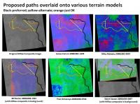
Overlay of my proposed paths onto the various UMSF terrain models:
-Mike -------------------- Some higher resolution images available at my photostream: http://www.flickr.com/photos/31678681@N07/
|
|
|
|
|
|
|
Oct 10 2008, 05:28 AM
Post
#547
|
|
 Senior Member Group: Members Posts: 2228 Joined: 1-December 04 From: Marble Falls, Texas, USA Member No.: 116 |
Thanks, Mike. I continue to enjoy your useful comparison montages. I guess all we need to do now is relax in the back seat and see where the first part of the ride takes us.
-------------------- ...Tom
I'm not a Space Fan, I'm a Space Exploration Enthusiast. |
|
|
|
|
Oct 10 2008, 08:26 AM
Post
#548
|
||
 Member Group: Members Posts: 236 Joined: 5-June 08 From: Udon Thani Member No.: 4185 |
I have been busy making the routefinding software more 'intelligent', this is the latest version of the computer-generated route suggestion, using the standard deviation trick. There are still several situations were seemingly the software gets confused but the general trend seems to be okay. Basically I just enter a departure position and a destination position and then let the software calculate the smoothest route.
Note I had to reduce the size of the image a bit in order to fit within the 1 Mb limit, the original calculation was done from 1 mtr/pixel. |
|
|
|
|
|
|
Oct 10 2008, 04:02 PM
Post
#549
|
|
|
Member Group: Members Posts: 252 Joined: 27-April 05 Member No.: 365 |
Gotta love the scoot thru that small crater about 3/4 of the way down the route. Tweaking the software so that it correctly skirts that crater could be an early adjustment with clear positive results.
|
|
|
|
|
Oct 10 2008, 05:32 PM
Post
#550
|
|
|
Member Group: Members Posts: 236 Joined: 5-June 08 From: Udon Thani Member No.: 4185 |
QUOTE (Burmese @ Oct 10 2008, 11:02 PM)  Tweaking the software so that it correctly skirts that crater could be an early adjustment with clear positive results. True, the software is basically designed to navigate through ripples, it more or less recognizes craters but somehow that small crater seems to escape its attention ;-). But, as has been said many times before, there is no way you can depend on computer-routefinding using only the HiRISE image-information, you will always need human eyes to find the correct route, I'm already happy that the software at least seems to agree in keeping as much as possible to the 'green' fields in the various analysis. Following the most westerly 'ray' of reasonable smooth terrain down south looks to me also the most favorable choice, problem remains that you will need to cross a patch of more rough terrain to get to the nearest 'green' field. |
|
|
|
|
Oct 10 2008, 06:22 PM
Post
#551
|
|
|
Senior Member Group: Moderator Posts: 2785 Joined: 10-November 06 From: Pasadena, CA Member No.: 1345 |
Could somebody tag up that western ray route for me?
I've got in mind a big project for later this evening... - Mike -------------------- Some higher resolution images available at my photostream: http://www.flickr.com/photos/31678681@N07/
|
|
|
|
|
Oct 11 2008, 02:54 AM
Post
#552
|
||
|
Senior Member Group: Moderator Posts: 2785 Joined: 10-November 06 From: Pasadena, CA Member No.: 1345 |
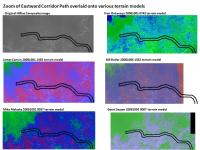
Zoom and overlay of the 'E corridor route' through the Victoria Crater debris apron using the various UMSF terrain models:
Higher resolution files can be downloaded here: E corridor route zoom HiRise image 25% resolution TIFF (13.9 Mb): http://www.speedyshare.com/897403843.html E corridor route zoom James Canvin 20081001 1435 FT terrain model 25% resolution TIFF (13.5 Mb): http://www.speedyshare.com/289868443.html E corridor route zoom Mike Malaska 20081002 0057 differential shift 10E5S terrain model 12.5% resolution.tiff (3.5 Mb): http://www.speedyshare.com/368252144.html E corridor route zoom Fran Ontanaya 20081001 0742 terrain model 12.5% resolution.tiff (3.4 Mb) : http://www.speedyshare.com/429750675.html E corridor route zoom Bill Butler 20081006 1532 2dfft terrain model image overlay.tiff (8.5 Mb): http://www.speedyshare.com/634581802.html E corridor route zoom Geert Sassen 20081003 0007 terrain model overlay.tiff (739 kb): http://www.speedyshare.com/547985714.html -Mike -------------------- Some higher resolution images available at my photostream: http://www.flickr.com/photos/31678681@N07/
|
|
|
|
|
|
|
Oct 11 2008, 04:01 PM
Post
#553
|
|
|
Member Group: Members Posts: 236 Joined: 5-June 08 From: Udon Thani Member No.: 4185 |
QUOTE (Juramike @ Oct 11 2008, 09:54 AM) Zoom and overlay of the 'E corridor route' through the Victoria Crater debris apron using the various UMSF terrain models: Good work! The problem I see with this easterly route is that during the second half of your track you seem to cross some quite scary looking terrain while still proceeding east (southeast originally, then turning east). If I zoom in on the full HiRISE images for this part of your track, the terrain looks very nasty and there doesn't seem to be much of a clear road proceeding east, you need to run straight against the ripples which will be bad. The route I outlined earlier crosses the worst terrain on a southerly track, it doesn't win you much terrain on an easterly direction though... One of the big worries is off course how long we can still proceed on 6 wheels, so I have the feeling we need to cross the 'bad' terrain as fast as possible, no matter in which direction, and get on a bit more even terrain where we might possibly be able to continue with 5 wheels, even if this means driving a longer route... However, I'm not a rover-driver, there might be other options etc, also we don't know what the new HiRISE images will tell us on the terrain further on... |
|
|
|
|
Oct 11 2008, 11:43 PM
Post
#554
|
||
 Senior Member Group: Members Posts: 1887 Joined: 20-November 04 From: Iowa Member No.: 110 |
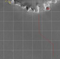
So, how far could Oppy drive in one sol? (dawn to dusk, commands downlinked the previous sol, results uplinked the next sol)
Here is ~500 meters, all green in one of James Canvin's analysis.
|
|
|
|
|
|
|
Oct 12 2008, 02:44 AM
Post
#555
|
|
|
Senior Member Group: Moderator Posts: 2785 Joined: 10-November 06 From: Pasadena, CA Member No.: 1345 |
Here is the historical track of Oppy's route overlaid onto a green-blue-red differential shift terrain model of Backshell to Endurance Crater.
A crop of Phil Stooke's route map shown for comparison. [EDIT 20081011 2328: corrected version in next post] -Mike (Gee, wouldn't it be interesting to compare predicted terrain with past navcam views?) -------------------- Some higher resolution images available at my photostream: http://www.flickr.com/photos/31678681@N07/
|
|
|
|
|

|
Lo-Fi Version | Time is now: 16th April 2024 - 12:04 PM |
|
RULES AND GUIDELINES Please read the Forum Rules and Guidelines before posting. IMAGE COPYRIGHT |
OPINIONS AND MODERATION Opinions expressed on UnmannedSpaceflight.com are those of the individual posters and do not necessarily reflect the opinions of UnmannedSpaceflight.com or The Planetary Society. The all-volunteer UnmannedSpaceflight.com moderation team is wholly independent of The Planetary Society. The Planetary Society has no influence over decisions made by the UnmannedSpaceflight.com moderators. |
SUPPORT THE FORUM Unmannedspaceflight.com is funded by the Planetary Society. Please consider supporting our work and many other projects by donating to the Society or becoming a member. |
|