A Delta River Near Hp ? |

  |
A Delta River Near Hp ? |
 Feb 14 2006, 12:58 PM Feb 14 2006, 12:58 PM
Post
#1
|
|
|
Senior Member  Group: Members Posts: 2922 Joined: 14-February 06 From: Very close to the Pyrénées Mountains (France) Member No.: 682 |
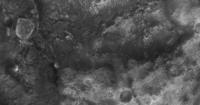
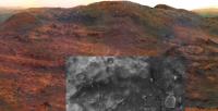
While focusing on Home Plate, I checked out the "Where are the rovers now" page yesterday on the JPL rover site. If you look closely to the attached file, the issued picture quote xxxxNew MexicoXXXX on the back and to the right of the picture. Very close and on top of where "New Mexico" is written there is a place (approx 5-600 m to the east of HP), that remind me a picture from the Huygens probe on Titan. It's a kind of a small "river delta". My best guess for sure is that it has been done by dust devil, but why dust devils will unit this way? It doesn't make sense to me. Did somebody ever sew this ? (use 204kB definition to see it).
Climber http://marsrovers.jpl.nasa.gov/mission/tm-...MERA_A749_2.jpg -------------------- |
 |
 
|
|
Feb 14 2006, 01:14 PM
Post
#2
|
|
|
Founder Group: Chairman Posts: 14434 Joined: 8-February 04 Member No.: 1 |
I think I know what feature you're refering to, but I think it's simply the edge of a ridge line, and not a small river channel as you're suggesting. The difference in brightness between various units can give a false impression of height I think.
Doug |
|
|
|
|
Feb 14 2006, 03:28 PM
Post
#3
|
|
|
Senior Member Group: Members Posts: 2922 Joined: 14-February 06 From: Very close to the Pyrénées Mountains (France) Member No.: 682 |
QUOTE (djellison @ Feb 14 2006, 02:14 PM)  I think I know what feature you're refering to, but I think it's simply the edge of a ridge line, and not a small river channel as you're suggesting. The difference in brightness between various units can give a false impression of height I think. Doug Doug, Thank you very much for your reply. Nevertheless, I join here the picture of the place to be sure we understand each other. Still look like a delta or plenty of ridges... Just a little back ground. I'm part of the 1/3 of the humanity still alive that witness Neil's first step on the moon "live". Always been interested in space, I traveled all the way to Pasadena to be with the Planetary Society for Voyager II encounter with Neptune and again for Spirit landing (what a great night!). So far I was following THE story on JPL's, MMB, Planetary blog's, etc but was not aware or your web site. I hope I can share now with everybody. 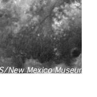 All the best and thank you for your wonderfull baby. (Gilles, the Everest's) climber -------------------- |
|
|
|
|
Feb 14 2006, 03:57 PM
Post
#4
|
|
 Chief Assistant Group: Admin Posts: 1409 Joined: 5-January 05 From: Ierapetra, Greece Member No.: 136 |
The linear features are apparent in a lot of shots from when Spirit was parked on the summit of Husband Hill.
They are located upslope and look like a heavily eroded spot or maybe rolling boulders have something to do with it. see http://marsrovers.jpl.nasa.gov/gallery/all...03P2261R2M1.JPG Nico 
-------------------- photographer, space imagery enthusiast, proud father and partner, and geek.
http://500px.com/sacred-photons & |
|
|
|
|
Feb 14 2006, 04:01 PM
Post
#5
|
|||
|
Senior Member Group: Moderator Posts: 4279 Joined: 19-April 05 From: .br at .es Member No.: 253 |
Welcome to the forum, climber!
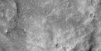
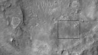
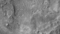
Here you have two pictures about this same area. The first is part of MOC image S12-00095 (same as in my current route map and JPL's traverse maps) while the second one is a crop from MOC image R02-00357 (which I have been using during a long time on the route map).
The delta/ridges/features which can be seen on the first can be hardly seen on the second; there is something there, but it's difficult to identify. Whatever it is -- and my guess is for something wind related -- could it be seen from current nav/pancam imagery? Edited: Nix, our posts seems to have crossed. Let me double check some L7 imagery I have somewhere here... |
||
|
|
|
||
|
Feb 14 2006, 04:48 PM
Post
#6
|
|||
|
Senior Member Group: Moderator Posts: 4279 Joined: 19-April 05 From: .br at .es Member No.: 253 |
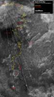
Two additional images with headings (*) to some known features and to the "unknown one".
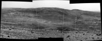
The first is from my route map, and the second is a stitch of sol 583 pancam imagery.
My guess is that the "unknown feature" is on the far side of McCool Hill. (*) I took the measurements from the summit, which is not quite correct but it's a good aproximation. |
||
|
|
|
||
|
Feb 14 2006, 05:01 PM
Post
#7
|
||
 Member Group: Members Posts: 531 Joined: 24-August 05 Member No.: 471 |
Alan's 2x vertical exaggeration overview and additional markings ...
Attached thumbnail(s)
-------------------- - blue_scape / Nico -
|
|
|
|
|
|
|
Feb 14 2006, 05:06 PM
Post
#8
|
|
|
Senior Member Group: Moderator Posts: 4279 Joined: 19-April 05 From: .br at .es Member No.: 253 |
Yes, you are right Nico.
|
|
|
|
|
Feb 14 2006, 05:35 PM
Post
#9
|
|
|
Senior Member Group: Members Posts: 2922 Joined: 14-February 06 From: Very close to the Pyrénées Mountains (France) Member No.: 682 |
QUOTE (SigurRosFan @ Feb 14 2006, 06:01 PM) Alan's 2x vertical exaggeration overview and additional markings ... So clear evidence now ! I thought it was the other way around ! Instead of spreading in a delta it looks like "they" unit! The boulder theory best fit what we see...it cannot be gullies, eh ? -------------------- |
|
|
|
|
Feb 14 2006, 06:10 PM
Post
#10
|
|
|
Senior Member Group: Members Posts: 3008 Joined: 30-October 04 Member No.: 105 |
Attached is my adaption of Sigur's montage of Alan's and Tesheiner's images.
These features may be the trails from boulders rolling downhill since there seems to be a ledge of the rock unit draped over McCool Hill (indicated in green) above the trails and extending around McCool Hill. But this is not likely since there is not much talus at the toe of the hill. Noting the prevailing wind direction (in blue) I'd guess these are sand ripples. --Bill -------------------- |
|
|
|
|
Feb 14 2006, 06:21 PM
Post
#11
|
|
|
Member Group: Members Posts: 531 Joined: 24-August 05 Member No.: 471 |
Bill, is that a yellow heart? Happy Valentine's Day.

-------------------- - blue_scape / Nico -
|
|
|
|
|
Feb 14 2006, 08:08 PM
Post
#12
|
|
|
Senior Member Group: Members Posts: 3008 Joined: 30-October 04 Member No.: 105 |
Now ain't that Freudian...
 --Bill -------------------- |
|
|
|
|
Dec 5 2006, 04:06 PM
Post
#13
|
|||
|
Senior Member Group: Moderator Posts: 4279 Joined: 19-April 05 From: .br at .es Member No.: 253 |
Let me resurrect this thread. Hey Climber! This was your very first one!
Do you remember this features? Here is a crop from HiRISE image PSP_001513_1655_RED, covering about the same area. Whatever it is (boulters, gullies, ?) it can be found at the right side of the pictures below.
|
||
|
|
|
||
|
Dec 5 2006, 06:47 PM
Post
#14
|
|
|
Senior Member Group: Members Posts: 2922 Joined: 14-February 06 From: Very close to the Pyrénées Mountains (France) Member No.: 682 |
QUOTE (Tesheiner @ Dec 5 2006, 05:06 PM) Let me resurrect this thread. Hey Climber! This was your very first one! Do you remember this features? Hi, Tesheiner! Yes I do remember it for sure. To tell the full story, at that time, I was not aware of the existance of UMSF  so I rose the question to Emily who actualy answered me...but after I discovered UMSF (I was amazed she even answer). so I rose the question to Emily who actualy answered me...but after I discovered UMSF (I was amazed she even answer).Back to the topic : the "delta" looks like a dune field to me here BUT it joins to a very interesting crack-like feature. Could still be a destination for Spirit even if not on the plan. Thanks Eduardo for your nice 
-------------------- |
|
|
|
|
Dec 5 2006, 08:33 PM
Post
#15
|
|
 Senior Member Group: Members Posts: 4256 Joined: 17-January 05 Member No.: 152 |
Based on albedo and morphology, that "dune field" looks more like a series of roughly parallel shallow gullies or ridges in the ground, rather than dunes of dust/sand on top of the ground. The "cracks" are certainly interesting too. Perhaps this is all related to the slope somehow. Great eye to have spotted these from the MGS images, Climber!
|
|
|
|
|

|
Lo-Fi Version | Time is now: 24th September 2024 - 12:02 AM |
|
RULES AND GUIDELINES Please read the Forum Rules and Guidelines before posting. IMAGE COPYRIGHT |
OPINIONS AND MODERATION Opinions expressed on UnmannedSpaceflight.com are those of the individual posters and do not necessarily reflect the opinions of UnmannedSpaceflight.com or The Planetary Society. The all-volunteer UnmannedSpaceflight.com moderation team is wholly independent of The Planetary Society. The Planetary Society has no influence over decisions made by the UnmannedSpaceflight.com moderators. |
SUPPORT THE FORUM Unmannedspaceflight.com is funded by the Planetary Society. Please consider supporting our work and many other projects by donating to the Society or becoming a member. |
|