Opportunity Route Map |

  |
Opportunity Route Map |
 Jan 19 2010, 05:55 PM Jan 19 2010, 05:55 PM
Post
#2636
|
|
|
Junior Member  Group: Members Posts: 23 Joined: 30-June 05 Member No.: 422 |
Using the Oppy+landing ellipse image for context (thanks, Centsworth!) I've placed Oppy's route on a pre-landing image showing the putative hematite distribution (warmer colors = more hematite). Looks like we're soon heading for spectrally distinct terrain . Wonder if the "ground truth" will really look any different? Fewer blueberries? Just more dust and duracrust on the ground?
-Kevin 
|
 |
 
|
|
Jan 20 2010, 05:29 PM
Post
#2637
|
|
|
Member Group: Members Posts: 235 Joined: 2-August 05 Member No.: 451 |
QUOTE (kwp @ Jan 19 2010, 12:55 PM)  Using the Oppy+landing ellipse image for context ... Thanks for this. I finally see why the Western Route makes sense. |
|
|
|
|
Jan 20 2010, 09:48 PM
Post
#2638
|
|
|
Senior Member Group: Moderator Posts: 4279 Joined: 19-April 05 From: .br at .es Member No.: 253 |
|
|
|
|
|
Jan 20 2010, 09:54 PM
Post
#2639
|
|
 The Poet Dude Group: Moderator Posts: 5551 Joined: 15-March 04 From: Kendal, Cumbria, UK Member No.: 60 |
What do you think? 2 more drives and we're there?
-------------------- |
|
|
|
|
Jan 20 2010, 10:08 PM
Post
#2640
|
|
|
Senior Member Group: Moderator Posts: 4279 Joined: 19-April 05 From: .br at .es Member No.: 253 |
Yes.

|
|
|
|
|
Jan 21 2010, 06:43 PM
Post
#2641
|
||
 Member Group: Members Posts: 813 Joined: 8-February 04 From: Arabia Terra Member No.: 12 |
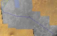
Here's a google earth path for the predicted route.
Edit: modified final part of path. See this post for reason.
Attached thumbnail(s)
Attached File(s)
|
|
|
|
|
|
|
Jan 21 2010, 07:53 PM
Post
#2642
|
|
 Member Group: Members Posts: 754 Joined: 9-February 07 Member No.: 1700 |
hey SFJCody, I tried to download your MER-b map extension via uTorrent, but it made no progress after several hours. Is there another way to do it?
Thanks! |
|
|
|
|
Jan 21 2010, 08:12 PM
Post
#2643
|
|
|
Member Group: Members Posts: 813 Joined: 8-February 04 From: Arabia Terra Member No.: 12 |
QUOTE (brellis @ Jan 21 2010, 07:53 PM) hey SFJCody, I tried to download your MER-b map extension via uTorrent, but it made no progress after several hours. Is there another way to do it? Thanks! Sorry about that.  I forgot to keep seeding it. I'm seeding it now so it should work. I forgot to keep seeding it. I'm seeding it now so it should work.
|
|
|
|
|
Jan 21 2010, 08:44 PM
Post
#2644
|
|
|
Member Group: Members Posts: 754 Joined: 9-February 07 Member No.: 1700 |
Much appreciated. I get scared when my Google Mars flights go off the HiRISE path

|
|
|
|
|
Jan 21 2010, 09:12 PM
Post
#2645
|
|
|
Senior Member Group: Moderator Posts: 4279 Joined: 19-April 05 From: .br at .es Member No.: 253 |
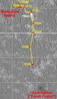
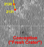
Sol 2131. Getting closer.
  Route_Map_Sol2131.kml ( 37.6K )
Number of downloads: 495
Route_Map_Sol2131.new.kml ( 38.99K )
Number of downloads: 617
Route_Map_Sol2131.kml ( 37.6K )
Number of downloads: 495
Route_Map_Sol2131.new.kml ( 38.99K )
Number of downloads: 617This post has been edited by Tesheiner: Jan 22 2010, 12:02 PM |
|
|
|
|
Jan 21 2010, 09:26 PM
Post
#2646
|
|
|
Member Group: Members Posts: 754 Joined: 9-February 07 Member No.: 1700 |
Thanks, SJFCody!
|
|
|
|
|
Jan 22 2010, 07:18 AM
Post
#2647
|
||
 Senior Member Group: Admin Posts: 3108 Joined: 21-December 05 From: Canberra, Australia Member No.: 615 |
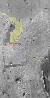
The map from the report on Oppy's traverse is quite interesting, albiet a bit small.
I've really stretched and sharpened the image and added Tesheiner's excellent route map on top. Thought that this might give everyone a better idea of where Oppy is and the road ahead.
|
|
|
|
|
|
|
Jan 22 2010, 07:22 AM
Post
#2648
|
|
|
Merciless Robot Group: Admin Posts: 8783 Joined: 8-December 05 From: Los Angeles Member No.: 602 |
Thanks, Astro0! Looks like once she's over the ridge it's all downhill from there, eh?
-------------------- A few will take this knowledge and use this power of a dream realized as a force for change, an impetus for further discovery to make less ancient dreams real.
|
|
|
|
|
Jan 22 2010, 09:24 AM
Post
#2649
|
|
|
Senior Member Group: Members Posts: 2920 Joined: 14-February 06 From: Very close to the Pyrénées Mountains (France) Member No.: 682 |
We're also 11km (nearly) dead South of the landing site. This could help for scale.
Astro0, does the colour difference in another 2 kms or so, on the scheduled path, shows when we'll be going downhill? Sorry it's not THAT clear to me. If yes, it'll be helpfull to put a clear mark on the map, I think. Pending we'll have a 360° pan very soon, we'll have to launch a "Find Victoria" campaing. Hopefully in another 6-8 months (I try to be conservative since winter's coming), we'll be at the start of the downhill path and could also start to look for mini-Endurance crater. All this to say: your post is very helpfull Astro0. -------------------- |
|
|
|
|
Jan 22 2010, 10:40 AM
Post
#2650
|
|
|
Junior Member Group: Members Posts: 71 Joined: 19-January 10 From: Grimsby, N.E. Lincs, UK Member No.: 5179 |
QUOTE (climber @ Jan 22 2010, 09:24 AM) All this to say: your post is very helpfull Astro0. I'd like to echo climber's comments above. To Astro0, Tesh, Phil and all the others who take the time to create and upload the diagrams/graphs/misc items a big thank you. It really does help a newbie such as myself to put a great deal of information and factors surrounding various rover decisions into context. Neil |
|
|
|
|

|
Lo-Fi Version | Time is now: 28th April 2024 - 07:09 AM |
|
RULES AND GUIDELINES Please read the Forum Rules and Guidelines before posting. IMAGE COPYRIGHT |
OPINIONS AND MODERATION Opinions expressed on UnmannedSpaceflight.com are those of the individual posters and do not necessarily reflect the opinions of UnmannedSpaceflight.com or The Planetary Society. The all-volunteer UnmannedSpaceflight.com moderation team is wholly independent of The Planetary Society. The Planetary Society has no influence over decisions made by the UnmannedSpaceflight.com moderators. |
SUPPORT THE FORUM Unmannedspaceflight.com is funded by the Planetary Society. Please consider supporting our work and many other projects by donating to the Society or becoming a member. |
|