Opportunity Route Map |

  |
Opportunity Route Map |
 Feb 18 2010, 07:16 PM Feb 18 2010, 07:16 PM
Post
#2681
|
|||
|
Member  Group: Senior Member Posts: 136 Joined: 8-August 06 Member No.: 1022 |
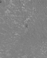
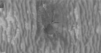
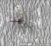
QUOTE (brellis @ Feb 13 2010, 01:28 AM)  thx Emily! It's like living a dream to fly around G.Mars  Hi all! I've been trying to find a streamlined way of posting my Opportunity location maps for public access for some time now, and hopefully that's going to start happening soon (today?). In the meantime, here are my latest (remember that Oppy hasn't moved in a few sols). First is the map at the HiRISE mosaic resolution of 25cm/pixel. Second is a 5cm/pixel projection of the Navcam panoramas onto the HiRISE image, around Concepcion.
Attached thumbnail(s)
|
||
 |
 
|
||
|
Feb 18 2010, 08:25 PM
Post
#2682
|
|
 Senior Member Group: Members Posts: 1084 Joined: 19-February 05 From: Close to Meudon Observatory in France Member No.: 172 |
your data is perfect as usual, Tim !
|
|
|
|
|
Feb 18 2010, 09:08 PM
Post
#2683
|
|
|
Senior Member Group: Moderator Posts: 4279 Joined: 19-April 05 From: .br at .es Member No.: 253 |
QUOTE (tim53 @ Feb 18 2010, 08:16 PM) I've been trying to find a streamlined way of posting my Opportunity location maps for public access for some time now, and hopefully that's going to start happening soon (today?). KML files for Google Mars on the MER website maybe? That would be great! QUOTE (tim53 @ Feb 18 2010, 08:16 PM) Second is a 5cm/pixel projection of the Navcam panoramas onto the HiRISE image, around Concepcion. I presume that's a projection of the 3D meshes generated from both L&R images. I would love to put my hands on such tools... |
|
|
|
|
Feb 18 2010, 09:10 PM
Post
#2684
|
|
|
Member Group: Senior Member Posts: 136 Joined: 8-August 06 Member No.: 1022 |
QUOTE (Tesheiner @ Feb 18 2010, 12:53 PM) KML files for Google Mars on the MER website maybe? That would be great! I'm hoping to do that at some point soon, but need to get the paper writ first that includes contributions from JPLers to the planning software used to make the maps. -Tim. |
|
|
|
|
Feb 18 2010, 09:12 PM
Post
#2685
|
|
|
Member Group: Senior Member Posts: 136 Joined: 8-August 06 Member No.: 1022 |
QUOTE (Tesheiner @ Feb 18 2010, 01:08 PM) I presume that's a projection of the 3D meshes generated from both L&R images. I would love to put my hands on such tools... Forgot to comment on this. Yes, that is from the project's planning software. But I believe there is commercial software out there to do something similar, provided the camera models can be generated. For example, I use Point Grey Research firewire cameras for planetary imaging (I'm an amateur astronomer), and Pt Grey has stereo camera systems and software to build 3-D files from stereo pairs. There must be others, but I haven't had any opportunities (sorry for the pun) to explore these myself. -Tim. |
|
|
|
|
Feb 21 2010, 08:52 PM
Post
#2686
|
|
|
Senior Member Group: Moderator Posts: 4279 Joined: 19-April 05 From: .br at .es Member No.: 253 |
|
|
|
|
|
Feb 25 2010, 08:49 PM
Post
#2687
|
|
|
Senior Member Group: Moderator Posts: 4279 Joined: 19-April 05 From: .br at .es Member No.: 253 |
|
|
|
|
|
Feb 26 2010, 04:49 AM
Post
#2688
|
|
|
Senior Member Group: Members Posts: 2082 Joined: 13-February 10 From: Ontario Member No.: 5221 |
Looks like we're leaving already!? Or are they stopping to examine the eject 'tail'?
|
|
|
|
|
Feb 26 2010, 11:10 AM
Post
#2689
|
|
|
Member Group: Members Posts: 910 Joined: 4-September 06 From: Boston Member No.: 1102 |
I think just going around all the rocks in this ray. A little dangerous to cross rock piles.
-------------------- |
|
|
|
|
Mar 1 2010, 09:08 AM
Post
#2690
|
|
|
Senior Member Group: Moderator Posts: 4279 Joined: 19-April 05 From: .br at .es Member No.: 253 |
|
|
|
|
|
Mar 1 2010, 09:19 PM
Post
#2691
|
|
|
Founder Group: Chairman Posts: 14432 Joined: 8-February 04 Member No.: 1 |
Guys - a polite reminder -this thread is for maps, or discussion of making/tweaking/interpreting the maps. There are routine threads for discussion of actual rover ops.
|
|
|
|
|
Mar 3 2010, 03:47 PM
Post
#2692
|
||
|
Senior Member Group: Moderator Posts: 4279 Joined: 19-April 05 From: .br at .es Member No.: 253 |
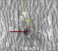
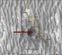
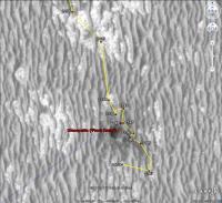
Yet another update. Sol 2170 i.e. yestersol.
 Route_Map_Sol2170.kml ( 41.58K )
Number of downloads: 482
Route_Map_Sol2170.kml ( 41.58K )
Number of downloads: 482 |
|
|
|
|
|
|
Mar 5 2010, 09:12 AM
Post
#2693
|
||
|
Senior Member Group: Moderator Posts: 4279 Joined: 19-April 05 From: .br at .es Member No.: 253 |
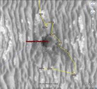
Here's the map for sol 2172.
Route_Map_Sol2172.kml ( 41.9K )
Number of downloads: 519I've included Santa Maria (Mini-Endurance) too. Note that the label is really displaced wrt the default low-res map; you must load SFJCody's maps to see if properly. |
|
|
|
|
|
|
Mar 6 2010, 09:02 AM
Post
#2694
|
|
 Junior Member Group: Members Posts: 73 Joined: 10-May 06 From: Spain Member No.: 770 |
Congratulations Tesheiner. Emily Lakdawalla has a link to one of your route maps for Opportunity in an article in the Planetary Society Blog.
|
|
|
|
|
Mar 6 2010, 12:13 PM
Post
#2695
|
|
|
Senior Member Group: Moderator Posts: 4279 Joined: 19-April 05 From: .br at .es Member No.: 253 |
Thanks Dig.
I read the article before your post but didn't realized the link was pointing here. In any case, I suppose that map was not the one used by SS on the conference but he would have used one from the project itself. That would be too much for the heart! 
|
|
|
|
|

|
Lo-Fi Version | Time is now: 27th April 2024 - 05:39 PM |
|
RULES AND GUIDELINES Please read the Forum Rules and Guidelines before posting. IMAGE COPYRIGHT |
OPINIONS AND MODERATION Opinions expressed on UnmannedSpaceflight.com are those of the individual posters and do not necessarily reflect the opinions of UnmannedSpaceflight.com or The Planetary Society. The all-volunteer UnmannedSpaceflight.com moderation team is wholly independent of The Planetary Society. The Planetary Society has no influence over decisions made by the UnmannedSpaceflight.com moderators. |
SUPPORT THE FORUM Unmannedspaceflight.com is funded by the Planetary Society. Please consider supporting our work and many other projects by donating to the Society or becoming a member. |
|