Jezero Delta Campaign, Sols 414-1000, 21 Apr 2022- 23 Dec 2023 |

  |
Jezero Delta Campaign, Sols 414-1000, 21 Apr 2022- 23 Dec 2023 |
 Apr 21 2022, 07:21 PM Apr 21 2022, 07:21 PM
Post
#1
|
|
|
Member  Group: Members Posts: 363 Joined: 13-April 06 From: Malta Member No.: 741 |
Think we can kick off the new phase of exploration at Jezero.
|
 |
 
|
|
Apr 22 2022, 02:28 AM
Post
#2
|
||
|
Solar System Cartographer Group: Members Posts: 10229 Joined: 5-April 05 From: Canada Member No.: 227 |
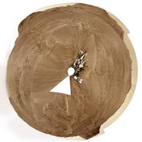
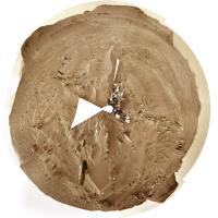
Yes, I was thinking that. The new delta campaign has begun according to the press release.
This is the sol 415 circular panorama showing us between the big drifts or ripples (aeolian bedforms), reminiscent of Opportunity many years ago. I haven't done the sol 414 version because I don't really want to deal with the multi-tile Navcams (4 tiles is bad enough, 16 is way too much for me to tackle with other work piling up). If someone makes a panorama for sol 414 I will use that to make a circular view. Phil
-------------------- ... because the Solar System ain't gonna map itself.
Also to be found posting similar content on https://mastodon.social/@PhilStooke Maps for download (free PDF: https://upload.wikimedia.org/wikipedia/comm...Cartography.pdf NOTE: everything created by me which I post on UMSF is considered to be in the public domain (NOT CC, public domain) |
|
|
|
|
|
|
Apr 22 2022, 08:20 AM
Post
#3
|
|
|
Merciless Robot Group: Admin Posts: 8785 Joined: 8-December 05 From: Los Angeles Member No.: 602 |
Topic title edited to include sol range- admin

-------------------- A few will take this knowledge and use this power of a dream realized as a force for change, an impetus for further discovery to make less ancient dreams real.
|
|
|
|
|
Apr 22 2022, 01:04 PM
Post
#4
|
|
 Senior Member Group: Members Posts: 2431 Joined: 30-January 13 From: Penang, Malaysia. Member No.: 6853 |
There's a NavCam thumbnail image of the sun from sol 416 with metadata that suggests there was a drive to site 23-1180 from site 23-0824. Looks like the images are late or they'll acquire them the following morning

|
|
|
|
|
Apr 22 2022, 05:01 PM
Post
#5
|
||||
 Member Group: Members Posts: 790 Joined: 9-May 21 From: Germany Member No.: 9017 |
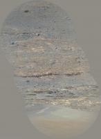
Sol 416 Supercam Remote Micro-Imager with Mastcam-Z and Navcam context
Finely laminated horizontal layering at the base of the hillside - are these the lake sediments we are looking for?
|
|||
|
|
|
|||
|
Apr 22 2022, 06:35 PM
Post
#6
|
|||
|
Solar System Cartographer Group: Members Posts: 10229 Joined: 5-April 05 From: Canada Member No.: 227 |
Very nice images, Tau. I hope we can get to those outcrops.
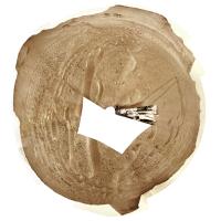
I changed my mind and made a sol 414 circular pan, using just the upper tier of the multi-tile Navcams to save time. Because of the projection I use the coverage even in just the upper tier is quite extensive. These circular images don't need a special viewer. They are like a standard polar projection except that the radial scale is changed (roughly equivalent to a stereographic projection). The basic idea is that the middle part is like a map:
and the full image includes the horizon features all displayed at the correct azimuth. North is always at the top (or very near it):
Phil -------------------- ... because the Solar System ain't gonna map itself.
Also to be found posting similar content on https://mastodon.social/@PhilStooke Maps for download (free PDF: https://upload.wikimedia.org/wikipedia/comm...Cartography.pdf NOTE: everything created by me which I post on UMSF is considered to be in the public domain (NOT CC, public domain) |
||
|
|
|
||
|
Apr 22 2022, 08:32 PM
Post
#7
|
|
 Member Group: Members Posts: 819 Joined: 3-June 04 From: Brittany, France Member No.: 79 |
End of sol 416 afternoon on Kodiak hill, taken with Navcam Left.

-------------------- |
|
|
|
|
Apr 23 2022, 03:13 AM
Post
#8
|
||
|
Solar System Cartographer Group: Members Posts: 10229 Joined: 5-April 05 From: Canada Member No.: 227 |
Sol 416, lots of rocks here but the biggest drifts are behind us.
Phil
-------------------- ... because the Solar System ain't gonna map itself.
Also to be found posting similar content on https://mastodon.social/@PhilStooke Maps for download (free PDF: https://upload.wikimedia.org/wikipedia/comm...Cartography.pdf NOTE: everything created by me which I post on UMSF is considered to be in the public domain (NOT CC, public domain) |
|
|
|
|
|
|
Apr 23 2022, 08:39 AM
Post
#9
|
||
|
Junior Member Group: Members Posts: 75 Joined: 8-July 15 Member No.: 7566 |
Remember that huge Mastcam-Z panorama from Sol 406? and at the left in the far distance there was an erosional surface preserved in the strata, but the image quality was quite poor? Well we now have our first high resolution view of that outcrop, taken on Sol 415. It shows the same tripartite system we've seen on Kodiak and elsewhere: inclined strata sandwiched between two horizontally bedded units.
|
|
|
|
|
|
|
Apr 23 2022, 10:21 AM
Post
#10
|
|
 Member Group: Members Posts: 648 Joined: 9-May 05 From: Subotica Member No.: 384 |
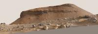
Kodiak Hill imaged by Mars Perseverances Mastcam-Z.camera on sol 416.
Just about 450 meters away from Kodiak hill. I think this is as close as we are going to see this feature ever.  Panorama Sol 416 M2020.jpg1 by Tomislav Bandin, on Flickr Panorama Sol 416 M2020.jpg1 by Tomislav Bandin, on Flickr
-------------------- The scientist does not study nature because it is useful; he studies it because he delights in it, and he delights in it because it is beautiful.
Jules H. Poincare My "Astrophotos" gallery on flickr... |
|
|
|
|
Apr 23 2022, 12:04 PM
Post
#11
|
||
|
Member Group: Members Posts: 790 Joined: 9-May 21 From: Germany Member No.: 9017 |
Yet another mosaic of Kodiak on sol 416, rotated to the horizontal
Interesting the multiple and partially opposed discordances in the upper center of the image
|
|
|
|
|
|
|
Apr 23 2022, 03:14 PM
Post
#12
|
|
|
Senior Member Group: Members Posts: 1057 Joined: 17-February 09 Member No.: 4605 |
Nice image Tau. There appears to be a transition in depositional environment from left to right with the distance between topsets and bottomsets narrowing with an apparent transition to a more energetic, turbulent flow. Unfortunately much of the transition point is obscured by detritus.
|
|
|
|
|
Apr 23 2022, 04:35 PM
Post
#13
|
|
|
Member Group: Members Posts: 251 Joined: 14-January 22 Member No.: 9140 |
Perhaps this was noted in earlier threads, but when we see a feature like this stand so tall above the surrounding plains, but cover such a small part of the area, that means that locally the erosion of other delta material must have been absolutely massive, right? And likely the only agent capable of carrying so much material away would have been catastrophic flooding, right? So while we see, in the hill and more generally in the delta layers built up by one era of water flow, there must have been subsequent eras (or episodes) of water flow that tore a lot of that down in the direction from the remaining delta material towards the center of the crater. Does that sound right or am I missing some other possible agent of erosion? Wind, impacts, and seismic activity from Syrtis Major seem like other possible agents in the destruction of the delta's original edge, but for so much material to be carried away, it seems like water had to be a major player.
|
|
|
|
|
Apr 23 2022, 05:36 PM
Post
#14
|
|
 Member Group: Members Posts: 716 Joined: 3-January 08 Member No.: 3995 |
It's possible the thick cross-bedded unit in Kodiak butte was formed by eolian processes. Sand dunes and drifts likely formed across the delta during dry periods. The cross-beds seem to dip to the southwest (or somewhere between south and east), which would be unexpected with those formed by fluvial processes on the delta. Perhaps coastal dunes formed as the lake level dropped and sediment became available to wind transport.
As for Kodiak butte itself, it could be an old crater pedestal, where the rock altered by the impact became slightly more resistant than the surrounding material. Over time, the rest is eroded away by mass wasting and wind, leaving the neat little butte. |
|
|
|
|
Apr 23 2022, 06:55 PM
Post
#15
|
|
|
Founder Group: Chairman Posts: 14434 Joined: 8-February 04 Member No.: 1 |
QUOTE (StargazeInWonder @ Apr 23 2022, 09:35 AM)  And likely the only agent capable of carrying so much material away would have been catastrophic flooding, right? Nope. Hundreds of millions of years and wind erosion are capable of this. See the best understood evolution of Gale Crater for similar massive volumes of wind erosion. An incredibly slow mode of erosion, over incredibly long periods of time can literally vanish mountains. |
|
|
|
|

|
Lo-Fi Version | Time is now: 26th September 2024 - 11:52 AM |
|
RULES AND GUIDELINES Please read the Forum Rules and Guidelines before posting. IMAGE COPYRIGHT |
OPINIONS AND MODERATION Opinions expressed on UnmannedSpaceflight.com are those of the individual posters and do not necessarily reflect the opinions of UnmannedSpaceflight.com or The Planetary Society. The all-volunteer UnmannedSpaceflight.com moderation team is wholly independent of The Planetary Society. The Planetary Society has no influence over decisions made by the UnmannedSpaceflight.com moderators. |
SUPPORT THE FORUM Unmannedspaceflight.com is funded by the Planetary Society. Please consider supporting our work and many other projects by donating to the Society or becoming a member. |
|