Printable Version of Topic
Click here to view this topic in its original format
Unmanned Spaceflight.com _ Past and Future _ Pathfinder site
Posted by: Phil Stooke Oct 29 2006, 04:50 PM
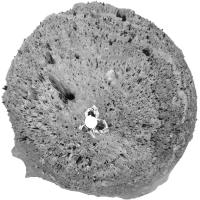
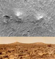
Presumably we will see a HIRISE image of the Pathfinder site at some point, so I am posting a polar view of the site here for comparison. I started with the Presidential Panorama. There was a slight mis-match between the ends of the pan - as if it had been slightly cropped for posting - which I can't fix, but it doesn't do too much damage to the polar view.
Phil
(PS - no, I can't really spare the time for this but you know how it is)
|
Posted by: djellison Oct 29 2006, 05:19 PM
That's a bit freaky, I was thinking "hmm - Pathfinder polar....I'll do that when I've had dinner" about 2 hrs ago.
Also interesting...
http://photojournal.jpl.nasa.gov/catalog/PIA02652
http://photojournal.jpl.nasa.gov/catalog/PIA01238
And especially
http://photojournal.jpl.nasa.gov/catalog/PIA00828
and
http://photojournal.jpl.nasa.gov/catalog/PIA01150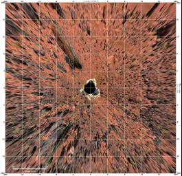
Doug
Posted by: Sunspot Oct 29 2006, 06:30 PM
How much bigger is Pathfinder than one of the MER's? Also, the large rock, Yogi, is even visible in the high resolution MOC images, so it should look amazing to HiRISE.
Posted by: djellison Oct 29 2006, 06:54 PM
The white grid on that image is 4m squares - and the lander would probably just about fit inside one, with the airbags poking out the sides of it. 15 to 20 HiRISE pixels.
Doug
Posted by: tedstryk Oct 29 2006, 07:41 PM
http://img141.imageshack.us/my.php?image=24744478608d265fc0aoqa6.jpg
I have posted it before, but this is a Sojourner polar from Sol 76. If it didn't move much after the lander died, it would be nearby.
Posted by: climber Oct 29 2006, 08:51 PM

Doug
...and if I'm not lost, Doug, you were not even 20 when Pathfinder get to Mars, correct ?
Posted by: Astrophil Oct 29 2006, 09:21 PM
Am I right in thinking that the current state of knowledge about the location is still reflected by this press release?
http://www.msss.com/mars_images/moc/2005/05/09/
Posted by: Phil Stooke Oct 29 2006, 09:51 PM
Yes, except that I prefer this slight adjustment, which I think gives a better match to the North Knob and other features.
Phil
|
Posted by: tedstryk Oct 29 2006, 11:39 PM
I was 18 at the time of the Pathfinder mission. I vividly remember waiting hours to download its "huge" mosaics via my 14.4 modem.
Posted by: djellison Oct 30 2006, 08:13 AM
I was 18, got up early to watch some coverage on BBC 2 here in the UK, and then went to the LIbrary to download the early pans onto a floppy disk, take them home, and print them out on a 24 pin B'n'W dot matrix  . Then, on a P60 (possibly with a 133MMX overdrive chip, can't remember) - trying to better line up the frames in the mosaics that were released...without much luck. I thikn that was the genesis of my image editing obsession.
Doug
Posted by: Phil Stooke Dec 5 2006, 01:57 PM
Well, I guess this is the next test, Pathfinder's site.
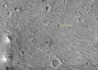
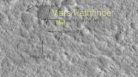
At the top of this thread is my polar panorama of the MPFD site. Then in post 8 I show the object identified by MSSS as the lander, in their press release. That's the point indicated by the convergence of the white lines. My best guess is just a few pixels from that again, a small correction based on the polar pan and azimuths to a few surrounding features.
This story also starts with Tim Parker, who (as Matt Golombek told me) spotted the Twin Peaks on the WSW horizon in the first few frames downlinked on landing day and recognized them from Viking images of the landing ellipse. Based on that identification he predicted that a crater rim would appear on the southeastern horizon when they got more images down, and sure enough there it was. Azimuths to distant hills and small details seen on the rim of that crater confirmed the match.
Phil
Posted by: AlexBlackwell Dec 5 2006, 05:36 PM
I think this image(s) will be the most fascinating one of the "known" landing sites. And if, by some miracle, Sojourner is resolvable, I know a few people who are interested where it ended up (e.g., to see if its onboard out-of-comm routines actually worked). Anyone want to start a pool?

Posted by: tuvas Dec 5 2006, 07:10 PM
You wouldn't be the first, as I understand, there's a pool going around with the MPF people at JPL/NASA as to where it ended up as well.
Posted by: AlexBlackwell Dec 5 2006, 07:11 PM
Yeah, I know about that pool, too

Posted by: djellison Dec 5 2006, 08:52 PM
And they're all OVER the place
Personally - my pin is near the fwd egress aid
Doug
Posted by: tim53 Dec 7 2006, 01:57 AM
Phil
|
|
Interesting...
Sometime in the past few years, the locations for VL-1 and MPF on Malin's website changed. I wonder why?
I have a somewhat different location.
 When I've finalized my updated map, I'll crop a chunk and post it here.
 That ain't MPF, and MOC didn't resolve Yogi, is my prediction.
It may have gotten the lander, though... ...now I'm looking for the backshell and heatshield, which ought to be the same size as for MER.
I'm betting we'll see Sojourner, too.
-Tim.
Posted by: AlexBlackwell Dec 7 2006, 06:38 PM
Sometime in the past few years, the locations for VL-1 and MPF on Malin's website changed. I wonder why?
What do you mean, Tim? The annotated images themselves changed, or just their location on the web server?
Posted by: tim53 Dec 7 2006, 06:41 PM
Their "best estimate" of the location of the lander changed. If you go to MSSS.com and get into the captioned releases, look under "landing sites". The release dated January 2000 has the correct location.
In the MOC C-PROTO, the lander is visible at that location (detected, but not resolved). So I won't need to post mine here, because it's the same.
-Tim.
Posted by: AlexBlackwell Dec 7 2006, 07:09 PM
Interesting. So you're saying that, in this http://www.msss.com/mars_images/moc/1_24_00_pathfinder/msss_final_best_est.gif, the "Present Best Estimate" annotation was changed?
Posted by: Phil Stooke Dec 7 2006, 07:14 PM
Here's the comparison. I had not noticed their change before - thanks, Tim.
Phil
|
Posted by: Sunspot Dec 7 2006, 07:27 PM
With Pathfinder being bigger than the rovers... i'm surprised MGS hasn't been able to provide a definitive location yet.
Posted by: AlexBlackwell Dec 7 2006, 07:33 PM
I guess I'm more confused. I was aware of the change in location between M11-2414 of January 2000 and the cPROTO image of May 2005. However, am I (mis?)reading Tim's post as saying that the latter has changed since it was originally posted?
Posted by: tim53 Dec 7 2006, 09:12 PM
Sorry for the confusion.
The January 2000 position where the "present best estimate" arrow points is the location of the lander. The May 2005 location is incorrect. I can't get any of my azimuth vectors, nor the MPF-based topographic map, to line up with that location.
Phil:
Your circle is at the "previous estimate" location of MSSS'. My original location was based on the Viking Orbiter 40m/pixel images (there were 4 overlapping there, so I was able to do a "super resolution" composite - really a noise reduction composite - of those images). I think it corresponds to an area big enough to accomodate both the locations given in the MSSS 2000 release, but not the 2005 location. Maybe by only a bit though. I figured a precision of about 100 meters for that location.
The C-PROTO is good enough that I'd predict that the "present best estimate" location, which is similar to my latest estimate, is accurate to within a few meters. ...but we'll see when HiRISE images the site.
-Tim.
Posted by: AlexBlackwell Dec 7 2006, 09:18 PM
Oh, okay. Now I get it. I suspected that's what you were saying, but thanks for spelling it out for me
Posted by: tim53 Dec 9 2006, 12:00 AM
Folks:
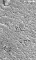
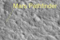
Here's my last pre-HiRISE plot of the location of MPF in MOC image R0501414. Slightly brighter dot at end of yellow line is the lander.
MSSS' January 2000 release had it right, but they changed their "best estimate" locations in the 2004 and 2005 releases.
I've searched until I'm nearly blind for anything that might be shouting "parachute" or "backshell", but I think the topography at this site is just too rough to identify them at MOC resolution.
-Tim.
|
Posted by: Sunspot Dec 9 2006, 12:14 AM
Whats this? Image processing artefacts a hair on the lens or rover tracks?
|
Posted by: djellison Dec 9 2006, 12:44 AM
I've searched until I'm nearly blind for anything that might be shouting "parachute" or "backshell",
That's two of us
I was very suprised there's no sign of the MPF backshell UNTIL....I saw the HiRISE imagery of the MERB Backshell and realised that MOC never really showed us the MERB backshell but actually just a large swathe of light soil kicked up by its impact...it should have been obvious when comparing to rover views of the hardware, but it never quite clicked into perspective. I'm fairly sure HiRISE will pick it up easily though.It's interestig to compare the backshells of all 4 spacecraft imaged so far. By virtue of their EDL timeline, the Viking backshells have floated softly to the ground and look just about perfect sat there. After bridle cut, it seems that the MERA chute reinflated thus letting the backshell land softly - but the same doesn't seem to be true of MERB, where the chute appears smaller on the ground and the backshell very obviously not intact suggesting no chute reinflation and thus a hard backshell landing. It will be interesting to see what Pathfinder did!
Doug
Posted by: tim53 Dec 9 2006, 12:50 AM
processing artifacts.
Posted by: Phil Stooke Dec 10 2006, 04:39 AM
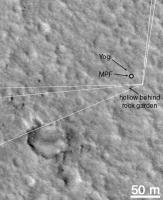
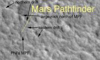
I like that location, Tim. I have labelled a few features seen in my circular pan (top of thread) - the long drifts north and east of the lander, and the big dark rock north of the lander on one of those drifts. A ridge extending off towards the SE shows up on mission topo maps, if I remember correctly.
Just to be ornery, and based on these few matches, I'll pick a neighboring little spot to be the lander and call your object Yogi...
Phil
|
Posted by: Sunspot Dec 10 2006, 10:40 PM
Regarding the final position of Sojourner. The rover was designed to circle the lander if communications were broken with the lander. But lander communications with Earth were lost first....isn't it possible that the lander was still functioning and communicating with the rover for some time after that happened? If so, Sojourner "might" be in the same spot it was last seen in.
Posted by: djellison Dec 10 2006, 11:47 PM
No - that's what I thought, but actually - it was due to go back to the lander, but at the same time it had a keep-out zone at the lander. It would have kept trying to get closer, whilst nudging the keepout zone...and probably turned right and circled the lander not by design, simply as a symptom of two fighting commands..get close and keep out.
However - eventually, the rovers knowledge of its own location would drift and it could have gone basically anywhere.
The lander had no commands to send to the rover, and I think the lack of communication from the lander was probably a lander failure, not just a comms failure. But to be honest, who knows. Personally, I give the rover a 50% chance of still being at Chimp, a 25% chance of being near the rear rover egress aid, and a 25% chance of having gone rogue and gone crazy
Doug
Posted by: Sunspot Dec 11 2006, 12:02 AM
awwww poor thing lol. Hopefully we'll find out soon.
Posted by: ustrax Dec 11 2006, 11:32 AM
I'll go for this 25%...
Posted by: MizarKey Dec 11 2006, 04:16 PM
My money is on the chipmunks having secured the sojourner...http://mars-news.de/life/mpf-anomalies.html
Posted by: AlexBlackwell Dec 11 2006, 08:17 PM
Anyone want to start a UMSF pool on this? We could slice up the landing site into grids and take predictions.
Posted by: ElkGroveDan Dec 11 2006, 08:19 PM
I'll take the far rim on sol 902.
Posted by: AlexBlackwell Dec 11 2006, 08:30 PM
Okay, looks like http://www.unmannedspaceflight.com/index.php?showtopic=3587&hl= got the ball rolling
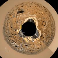
Posted by: PDP8E Jan 10 2007, 08:10 PM
Pathfinder Overhead shot is up on the HIRISE site
http://hirise-test.lpl.arizona.edu/images/2007/details/cut/MPF_parts_2.jpg
cheers!
Posted by: djellison Jan 11 2007, 04:42 PM
Twin peaks is suprisingly a bit "hmm - where'd all those features go?"
Doug
|
|
Posted by: AlexBlackwell Jan 11 2007, 08:50 PM
Question: How accurate was the analysis based on the MOC cPROTO images? (http://www.msss.com/mars_images/moc/2005/05/09/, http://www.msss.com/mars_images/moc/2004/01/04/)
Posted by: tim53 Jan 11 2007, 10:05 PM
MSSS had the MPF located accurately in their January 2000 captioned release. Viking 1 is about 50 meters southwest of the actual location.
-Tim.
Posted by: jamescanvin Jan 11 2007, 11:23 PM
And looking at your post http://www.unmannedspaceflight.com/index.php?showtopic=3409&st=0&p=77300&#entry77300 I see that you were EXACTLY right. Well done Tim.
|
Overlay of Tims position 'Mars Pathfinder' label on the MOC (plus Phil's annotations) and the Hirise with the 'MPF' label.
James
Posted by: Toma B Jan 11 2007, 11:24 PM
Has anybody downloaded that full res .jp2 image of Pathfinder site?
Before this (really unnecessary) site update at least see how big is that file...now for some reason that information is not available... 
Could somebody please post a crop of those "twin peaks" in full resolution?
Posted by: Sunspot Jan 11 2007, 11:37 PM
Why don't the solar panels show up at all? Too much dust?
Posted by: jamescanvin Jan 11 2007, 11:52 PM
See the old style page http://hiroc.lpl.arizona.edu/images/PSP/PSP_001890_1995 it's 849Mb.
For Twin Peaks see Doug's post above (39)
James
Posted by: djellison Jan 12 2007, 12:01 AM
Not full res by the way....I downsized it about 50%
Doug
Posted by: djellison Jan 12 2007, 12:03 AM
Best thing I could find to overlay it one of these...
http://photojournal.jpl.nasa.gov/jpeg/PIA00752.jpg
(anim gif attached)
Doug
|
Posted by: Myran Jan 12 2007, 12:04 AM
Thank you PDP8E.
And now lets see for those two harder to find ones, but that we might have a realistic chanse of finding. The polar lander and beagle. But we wont have the advantage of surface images to guide us right there. But if found would at least give some hint of what actually happened to them.
Posted by: jamescanvin Jan 12 2007, 12:18 AM
Comparing the jpgs released by NASA with the jp2 from HiROC.
|
There is quite a difference, particularly in the apparent angle the two 'ramps' make with each other. I don't think that the jpegs are of PSP_001890_1995 but of another image (to form a stereo pair).
James.
Posted by: djellison Jan 12 2007, 12:49 AM
Not sure if it really adds anything - but worth a go anyway.
Doug
|
Posted by: tim53 Jan 12 2007, 01:38 AM
I don't know if it's common knowledge yet, but for those of you having trouble displaying these ginormous JPEG2000 images, there's a great viewer called "Expressview" by LizardTech that you can download for free. I know it's available for Mac OS X (where I hang out), but I think it's also available for PCs.
There's supposed to also be a JPEG2000 plugin for Photoshop CS2, but I don't have it.
-Tim.
Posted by: AlexBlackwell Jan 12 2007, 01:47 AM
Tim, given that we now know the precise location of three martian landers in cartographic space, and given that we already know their position in inertial space from radio tracking, how much of an improvement will there be in the Mars control net?
Posted by: elakdawalla Jan 12 2007, 01:53 AM
B)-->
Could somebody please post a crop of those "twin peaks" in full resolution?
[/quote]
Here is the area around the lander including the "twin peaks" at full resolution, JPEG format, about 8 MB. I was going to do some other segments but my computer is huffing and puffing on these, and I just don't have the time to sit and wait for them to export...I tried storing the 800 MB file on a networked hard drive rather than my laptop and OpenEV runs nightmarishly slow that way.
http://filicio.us/tpss3/files/12366/pathfinder_landing_area.jpg
--Emily
Posted by: nprev Jan 12 2007, 02:06 AM
Doug
Actually, it did, Doug.
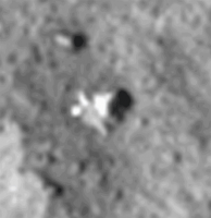
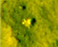
I hate to come off as a heretic, but I have to wonder if Sojourner has actually been spotted. Doug's image seems to show a dark area immediately "south" of the lander that looks a lot like the soil churned up by the rover. If this is obvious (and correct), then why isn't Sojourner?

Pure speculation: Is the "airbag reflection" @ 9 o'clock immediately next to the lander actually the rover? Conversely, at 3 o'clock there's a light spot within the shadow of the lander which might also be Sojourner. (Disclaimer: I can't visualize the landing bag geometry, so this may well be completely off-base).
(Posted completely in the time-honored tradition of scientific skepticism...
)
Posted by: ElkGroveDan Jan 12 2007, 02:57 AM
Now that we see the location of the backshell, chute and heat shield segments does anyone want to make a case for a likely touchdown location and/or bounce path?
Surely there are outer parameters (and a direction of motion) that these events must fall within based on the final locations of the EDL debris.
Tim? Doug?
Posted by: tim53 Jan 12 2007, 05:01 AM
Pretty much all of the improvement in the control net, and tying the geography (images) to it has come from all that MOLA data. It's such a reliable dataset that I've used it in all my "new" basemaps to register the images to in locating the landing sites.
I will have to check, but I think the lat/lons I came up with agree with those derived by the MOLA team to within a few thousandths of a degree, which is somewhat reassuring...
-Tim.
Posted by: tim53 Jan 12 2007, 05:10 AM
I hate to come off as a heretic, but I have to wonder if Sojourner has actually been spotted. Doug's image seems to show a dark area immediately "south" of the lander that looks a lot like the soil churned up by the rover. If this is obvious (and correct), then why isn't Sojourner?
Pure speculation: Is the "airbag reflection" @ 9 o'clock immediately next to the lander actually the rover? Conversely, at 3 o'clock there's a light spot within the shadow of the lander which might also be Sojourner. (Disclaimer: I can't visualize the landing bag geometry, so this may well be completely off-base).
(Posted completely in the time-honored tradition of scientific skepticism...
)I'm not quite sure I see what you're referring to. I don't see anything in the image to suggest that any of the known disturbed soil surfaces are still dark.
If you look at the gallery pan, at the rover petal, you'll see that the protruding portion of airbag material is shiny, not just white. I think this is glinting in the HiRISE view. Also, the lander's solar panels are indistinct from the surrounding soil in the red (at least), so I suspect Sojourner's is as well. If so, all we may be seeing is its shadow.
It's certainly possible (and intriguing) that it isn't Sojourner there, and that spot is just a fortuitous lighting effect on the small rocks and soil surfaces there in the gallery pan, but it doesn't look remarkable in any othr way from the ground view.
I've looked pretty far afield of the lander for anything like a snail trail with a "rock" at the end, and haven't found anything.
-Tim.
Posted by: tuvas Jan 12 2007, 05:40 AM
James.
So far as I know, there hasn't been another picture taken to complete the stereo, but it could be a geographic projection or something similar to that... I did a quick check, and unless the new image didn't have the word pathfinder in the description, it hasn't been taken. So I'd bet it has something to do with geometric projections or something. It could also be an affect of JPG compression. Which of the two was the HiRISE JP2?
Posted by: jamescanvin Jan 12 2007, 05:58 AM
jpg on the left, jp2 on the right.
That's what I thought at first, but they are very different and it looks for all the world like the jp2 is taken from directly above and the jpg from somewhat side on, making the two ramps not appear antiparallel. I'm gonna take some convincing that those aren't two separate images from different angles!
One question: When can we expect colour?
James
Posted by: djellison Jan 12 2007, 08:50 AM
Well - First bounce, Lander and Backshell tend to form a fairly large triangle of several hundred metres on a side. If there were a little red graph of Pathfinder bounces in the way we saw one for MERA and B, then one could overlay - but I dont' recall anything like that.
Unfortunately, I don't have the brains to reconstruct one from the PDS EDL data in the Atmospheres node.
nprev - what you're seing, imho, is a bit of a dark patch which is the resolving of a few cobbley sized rocks. The combination of a bright part and a dark part ( i.e. something with relief to it ) in a space where the pans tell us there is nothing that size there.....it's fairly convincing.
I'm fairly convinced there's two obs as well James - I really don't think that's a projection issue - it's a different picture.
Doug
Posted by: Nix Jan 12 2007, 10:11 AM
Twin Peaks, Backshell & Parachute, MPF itself -100% crop. (~80% jpeg)
http://www.awalkonmars.com/PSP_001890_1995_RED_crop100per.jpg
Nico
edit: I just noticed Emily had already provided a somewhat larger crop on the previous page in this thread.
edit2: just for fun, another try at a stereo, based on James' and Doug's efforts.
|
Posted by: ElkGroveDan Jan 12 2007, 04:09 PM
http://photojournal.jpl.nasa.gov/jpeg/PIA00752.jpg
Good one Doug. I tossed it into Adobe ImageReady for a smoother back and forth.

|
Posted by: tim53 Jan 12 2007, 04:46 PM
The lander bounced in to it's final resting place from the east. Rob thinks the first bounce was to the southeast of the landing site, and has suggested that the "Malin Object" we saw from the ground is airbag cover that came of during an early bounce.
After landing, I located all the bounce marks I could see out from the lander to the east. I've looked for these in the HiRISE image, and can't see them. They would be dark spots, more like Spirit's than Oppy's. They must be gone.
Doug
Nope, there is only one image of the site to date. The earlier attempt was "lost in translation" such that the only coverage that came from the DSN is to the east and west of the lander. Not over the lander.
I think what you're seeing is a combination of jpeg artifacts and processing/projections done to the two versions of the image you're referring to. When I look at the anaglyph posted above, for example, I don't see sensible relief in the surrounding area, which ought to show up in stereo at this scale.
-Tim.
Posted by: tuvas Jan 12 2007, 05:50 PM
One question: When can we expect colour?
James
I can assure you there aren't two images that were received, the first attempt, as tim stated, was lost with problems with DSN. We received only a few channels, and none of them was with the lander included.
As for color, well, that will come with the next image to finish the stereo, which AFAIK, hasn't yet been assigned. The lander was in RED6, which you're probably aware just missed the color strip.
Posted by: Chmee Jan 13 2007, 02:16 PM
(Posted completely in the time-honored tradition of scientific skepticism...
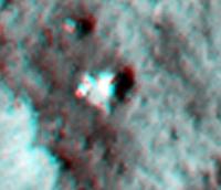
)I have to agree. Sojourner is not obvious in pictures I have seen. The best candidate I can see is the bright patch immediately next to MPL. I know that others have stated it may be the airbag, but it seems far to reflective and large for the small amount of airbag exposed. Wasn't Sojourner programmed to approach MPL if it lost communications? Perhaps it is "snuggled" next to MPL waiting for a signal that never came?
Posted by: djellison Jan 13 2007, 03:28 PM
No - there really is a big bit of airbag material - with exposed foil etc - just there.
http://mars.jpl.nasa.gov/MPF/ops/81220_full.jpg
See the glare it produces.
See the foil here..
http://mars.jpl.nasa.gov/MPF/ops/81957_full.jpg
Sojourner is never going to be obvious - it's barely at the resolving power of HiRISE and is going to be a very similar colour to the terrain...much like Spirit is today
http://pancam.astro.cornell.edu/pancam_instrument/images/True/Sol1045A_P2589_1_True_RAD.jpg
What we DO see with the HiRISE images is some rocks that appear where we expect them to - and then one about Sojourner that is where we don't expect one, in a place where it's entirely possible Sojourner could have driven to.
The sequence was never onboard to actually circle the lander ( as I used to think ) but infact to return to the lander but simulatanious remain outside a keep-out zone. She would probably (given enough time ) have tried to go around the lander anti-clockwise as a result of that. However - she wouldn't have got too close to the lander as the lasers would/should have stopped that happening.
There's no OBVIOUS sign of Sojourner - but that object that does look out of place - and in a spot that is easy to imagine Sojourner getting to - it's the only real candidate if the old girl stayed 'local'
Doug
Posted by: Decepticon Jan 13 2007, 07:44 PM
I'm confused, can someone point to the last known position of the little rover?
Posted by: djellison Jan 13 2007, 08:03 PM
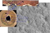
If you look at this one..
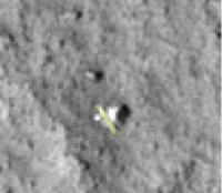
http://hiroc.lpl.arizona.edu/images/2007/details/cut/MPFtopo_HiRISE_annot.jpg
Sojourner was backed up to the rock called Chimp - centered on about -1X, -10Y on that graph.
Doug
Posted by: dvandorn Jan 13 2007, 08:32 PM
IIRC, the analysis of the Ares Vallis site and the rocks found in the vicinity of the lander were found to be consistent with transportation and deposition of large rocks via catastrophic flood events. At larger scales, the Ares Vallis region certainly looks to have been the site of catastrophic outflow flooding, though it must have happened a long time ago.
However, it interests me a great deal how MRO reveals that the rocks in the "Rock Garden" seem to be defined be the rim of one of the many, many linearally-alined elongated depressions that make up the terrain in the area. And that a majority of large rocks visible in the MRO image are alined along the rims of these depressions.
If many to most of the rocks in the area were washed there via catastrophic floods, why should they appear preferentially along rim crests? From above, a majority of these "rock gardens" seem to have been the rims of the original depressions, which have since been eroded away to leave blocks of the materials that made up the rims.
Unless the *entire* surface we see here was laid down by catastrophic floods, down to a depth of several meters, then it seems to me that the rims of depressions in the ground ought to be made of the materials that pre-dated the floods. Which means that the surface that was flooded was already made up of rocks with a seemingly wide variety of types and formations.
So, by the process of elimination, we seem to have two different possibilities: either the entire surface at Ares Vallis (and, by extension, at other catastrophic outflow channels on Mars) is made up of rocks and fines deposited there by the flooding event(s), or the original terrain that was scoured down to what we see today was already composed of all different types of rocks, from frothy and andesitic lavas to sedimentary and conglomerate rocks.
Interesting...
-the other Doug
Posted by: tedstryk Jan 13 2007, 08:47 PM
Sojourner was backed up to the rock called Chimp - centered on about -1X, -10Y on that graph.
Doug
Yep. Here is the last end-of-day view (planet day 80), as well as the last view from Sojourner on planet day 81. Planet day 83 would be the last regular day of the MPF mission, and Sojourner had just finished up its APXS study of Chimp, but had not yet moved.

Posted by: Phil Stooke Jan 13 2007, 10:05 PM
Replying to dvandorn,
Another possibility is that the old water-deposited stuff (from events more like giant mudflows than rivers, and some espouse a glacial origin as well) has subsequently been peppered with many small impacts, and the blocks are really just ejecta. I never believed the identification of imbrication in these rocks. So I think Rock Garden is a small blocky crater rim.
Phil
Posted by: jumpjack Jan 14 2007, 04:55 PM
http://pancam.astro.cornell.edu/pancam_instrument/images/True/Sol1045A_P2589_1_True_RAD.jpg
there are several things I can't understand:
- why aren't Spirit and Opportunity experiencing same dusty-doom of MPF? (or vice-versa) Isn't MPF landing site not windy at all?

- are currently Spirit panels in such a condition of the linked image???
- If NASA knew dust would at last stopped solar panels from working, why didn't they design movable solar panels, which can be folded in the original position and the unfolded again? This wuould have easily removed dust from panels surface!
And, where can I find an annotated image of MPF landing site?
Posted by: jumpjack Jan 14 2007, 05:55 PM
I found a Sojourner route map:
http://mpfwww.jpl.nasa.gov/MPF/roverview/table.html
|
Posted by: jumpjack Jan 14 2007, 05:57 PM
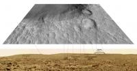
And here it is a full annotated panorama (from same site above).
|
|
Posted by: tedstryk Jan 14 2007, 06:03 PM
Pathfinder was killed by battery failure. They tried to get it to run directly off the solar panels (rather than from the solar panels to the battery), so that it could at least work during the day, but it didn't work. When Viking 2 died, it was similar - in this case, the RTG was still putting out power, but the battery failed. Power went from the RTG to the battery to the spacecraft, and attempts to run directly off the RTG failed. If you look at pathfinder's pictures of the solar panels taken just before it failed, they still look clean. BTW, that pan has some labels, although some features, like mini-matterhorn, located at the rightmost part of the pan, next to the edge of the airbag, are not listed.
Posted by: jumpjack Jan 14 2007, 06:55 PM
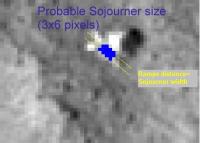
My 2 cents about possible final sojourner location.
|
Posted by: djellison Jan 14 2007, 07:52 PM
Which bit do you think is sojourner?
Doug
Posted by: jumpjack Jan 14 2007, 08:10 PM
Doug
I'm donloading the TIFF version of the image...

But from jpeg version I obtained this image.
Given that stero pairs allow a virtual resolution increasing and that TIFF are less noisy, I think Sojourner could perhaps be found by comparing 3d panoramas to 3d orbital photos (3d allows better association between objects in panorama and objects in aerial map).
|
Posted by: jumpjack Jan 14 2007, 08:14 PM
BTW: why is the lander so bright? Shouldn't it covered with dust too??? Not airbags perhaps, but at least ramps and Sojourner original location!
Was the lander affected by battery failure, or the rover?
Maybe Sojourner is STILL rolling some kilometers away from lander, having lost its way??? 
Is this theoretically possible??
Posted by: Phil Stooke Jan 14 2007, 08:21 PM
Sorry, jumpjack, but Sojourner was much smaller than your size of 3 by 6 pixels. It is only about 1 pixel wide. The double line you show for the ramp is too wide as well. I think Tim Parker's identification is most likely correct.
Phil
Posted by: jumpjack Jan 14 2007, 08:39 PM
Phil
Ops, you are right, upper left "ramp" is actually an airbag, as per this attachment!
http://www.unmannedspaceflight.com/index.php?act=Attach&type=post&id=8990
Where can I download from thee two images used for this animation?
|
Posted by: djellison Jan 14 2007, 08:42 PM
The overhead projections are from the Planetary Photojournal.
Doug
Posted by: jumpjack Jan 14 2007, 08:44 PM
Phil
which post are you referring to?
Posted by: jumpjack Jan 14 2007, 08:47 PM
Mabye IR will solve this issue!
They'd like to study future pictures of the Pathfinder landing site from HiRISE, this time taken with higher resolutions in infrared and blue-green, in the hopes that one of these color wavelengths would be reflected by Sojourner's solar panels. Then they'd get positive ID on the toaster.
http://science.qj.net/MRO-finds-Pathfinder-MAYBE-or-not-finds-Sojourner-too/pg/49/aid/79098
What are they talking about? Where do they think Sojourner is??
Posted by: djellison Jan 14 2007, 08:52 PM
That is a little missleading.
HiRISE is 10 x 2000 pixel wide CCD's to make 20,000 pixels wide. The middle two of these are also replicated in the Near IR and Blue/Green - so giving a false colour 4000 pixel wide swath down the middle of HiRISE images. It is not at higher resolution though - it is the same res as the rest of the instrument. They missed Pathfinder with the colour first time around, but I am sure they will have another go at it.
The idea is that while everything looks very 'similar' in the normal red channels - perhaps the lander and sojourner will be a little more forthcoming with the nIR and B/G channels.
Please look at the rest of this thread and the HiRISE website for their preliminary location identification which is already very compelling given the fact that there is a roughly sojourner sized feature at a space where no such feature exists from the Pathfinder surface imagery.
Doug
Posted by: jamescanvin Jan 14 2007, 09:56 PM
Yeah after my last post I went and made an anaglyph of the whole region with both jpg/tif and jp2 coverage and couldn't really convince myself that there was any stereo, so fair enough it's the same image. I did have to do quite a bit of streching to get the images to overlay so clearly one had been projected differently. I'm still really surprised at how different the lander looks in each image though.

Ahh so you missed the lander with the colour this time, I wasn't aware of that, thanks.
James
Posted by: edstrick Jan 15 2007, 11:42 AM
".. Power went from the RTG to the battery to the spacecraft, and attempts to run directly off the RTG failed."
Actually, as I understood it, the RTG system was putting out it's constant 50 or so watts of power, but *DOING* anything useful, most specifically playing data back off the tape recorder or taking a real time image AND transmitting the data and doing spacecraft housekeeping, took more power than that 50 watts (or whatever). The battery couldn't buffer the surge in power demand, so the spacecraft had an instant "brownout" drop in voltage and safed itself every time they tried to do something. They turned off the vehicle's transmit mode to the last surviving orbiter (both direct-to-earth transmitters had failed), which shortly after ran out of attitude control gas and was turned off too. End Of Mission, with or without battery failure.
I *think* Pathfinder died while they were trying to configure it for a no-battery mode, and the software they uploaded wasn't really ready... some capabilities they were planning to put in weren't there yet or something, so they uploaded a "beta" version when it became an emergency. The expectation was that it wouldn't last long due to damage from deep thermal cyclling even if they could get it into a no-battery mode, but they were hoping for days or even weeks.
It's unlikely the rover went that far. It would have bumped into rocks and probably <i presume> gone into safe mode and hollered "Mama!", and gotten no answer.
Posted by: djellison Jan 15 2007, 11:58 AM
The rover was programmed to - after a while - backed up to where it last had succesfull comms with the lander. If that failed - it was programmed to drive back toward the lander - but also maintain a keep-out zone around the lander. This would have resulted in the rover heading back toward the lander ( a fairly clear route that indeed includes the spot where we think we see Sojourner ) and then probably turning right and circulating that way until its position knowledge would drift and it would start roving just about anywhere.... the 'return and circle' sequence didn't actually exist per se.
I'm fairly confident that Sojourner could very easily have got to that point we see in the HiRISE images - I can quite believe it got that far.
Doug
Posted by: jumpjack Jan 15 2007, 12:59 PM
Imagine if in next hirise shots we'll se just a single pixel different in each image...
Maybe Sj is circling around the lander since 10 years!
ok, just kidding...
Posted by: djellison Jan 15 2007, 01:08 PM
You jest - it would be suprising, but not beyond the realms of possible to see that little feature move. Sojourner is designed to be totally solar powered and did work for about a month with no other power source after its non-rechargable batteries had exhausted. She might be too dusty - and things may be broken inside - but it's plausable that the old girl wakes up every morning, tries a bit of a move, and then goes to sleep with the setting sun. Despite the enormous cool factor - this would also help confirm the current Sojourner feature...rocks don't tend to walk
Doug
Posted by: AndyG Jan 15 2007, 03:25 PM
Reality to one side - naturally the Romantic in me sees the plucky little rover wandering across the Martian sands, stopping now and again only to admire the view (and because of the darkness at night), wondering why she's not heard from home...
...0.4 m/min for 9-and-a-half-years makes for - a thousand kilometres! Hey, she could be just have made it to Viking 1, or be halfway to Oppy by now.
(Is MSL reading this???)
Andy
Posted by: tedstryk Jan 15 2007, 05:57 PM
Nix, I hope you don't mind my http://www.strykfoto.org/acrawlonmars.html of your site.
Posted by: Nix Jan 15 2007, 06:19 PM
No I don't mind at all, it's quite amusing actually!
What's picture #77?
I really enjoy your work on MPF btw... and glad to see your site growing!
Nico
Posted by: tedstryk Jan 15 2007, 06:33 PM
No I don't mind at all, it's quite amusing actually!What's picture #77?
I really enjoy your work on MPF btw... and glad to see your site growing!
Nico
It is a fragment of an image that would have been very similar to sol 78, but most of it was lost in transmission (I am not sure if this happened between Sojourner and the lander or between the lander and earth).
Posted by: djellison Jan 15 2007, 08:06 PM
I'm still wondering how you did those - superb work, a data set that needed a proper 'going over' - and oh boy did you do that 
Doug
Posted by: tedstryk Jan 15 2007, 09:00 PM
Doug
To tell it the short way, slowly.
To tell it the long way, the first part was figuring out how to put the puzzle together. The images were all transmitted in little subframe chunks, with the exception of four large images. Those four images all had areas that were horribly overexposed in some of the colors. Then I picked an image to use as my standard (after converting everything to 16 bit). I did my best to tweak the brightness and contrast of the other images until they matched. Also, in a few of the images, I had to correct for shadows moving between the framlets. In some of the very underexposed framelets, I had to do a lot of noise reduction, and I had to adjust the color to correct for the fact that there was an annoying "glow" in blue that skewed dark areas. Once this was done, I re-aligned the color channels. Most significantly, the green channel.
Doug, I think it was you who once asked about making red-blue images and chucking the green channel. This does not work well, because the CCD had far more green pixels than anything else, so the already really bad resolution gets worse. However, there was an annoying echo in the green channel, which had to be reconstructed for each image, and then subtracted. I greatly smoothed the color data, using photoshop's smart blur so as to blur together groups of pixels without bleeding occuring between the surface and pieces of the rover.
I wish I couldh have automated the process of cleaning and aligning the channels. However, nearly all the mosaics of framelets only cover a fraction of the CCD, and there is no information on the PDS cd to indicate where on the CCD each one is from. Since the severity and the direction of the distortion varies throughout the image, one had to manually assess the situation for each image.
One problem was the fact that the camera used some type of auto-stretching. So, if there was a glint off a piece of a rover in an image, the surrounding area would be nearly black. Then, in the next image, with no glint, it would be a nice, bright, well exposed image. With no guide to calibrate the rebalancing process, a lot of guesswork was required. Also, because the bright areas were totally saturated (most of the time), it required a lot of guesswork to reconstruct the greyscale to match other images. Often, pieces of the rover were washed out in some of the channels. That is why color varies in some of the images...a standard was really hard to find.
Soon, I hope to do the much easier task of working with the front camera images.
Posted by: djellison Jan 15 2007, 09:06 PM
Thanks for that The real pity is that they didn't get a GOOD colour image of the lander. A few nice B'n'W ones - but not a nice colour one really.
Doug
Posted by: tedstryk Jan 15 2007, 09:10 PM
I don't think it ever got ANY color images of the lander.
Posted by: djellison Jan 15 2007, 09:30 PM
Hmm - I'm sure I remember an image that showed a bit of egress aid - but now I'm not so sure. Maybe an overactive imagination coloured in a greyscale one.
(edit...
Perhaps I thought it was this one - http://pdsimg.jpl.nasa.gov/data/mpfr-m-rvrcam-2-edr-v1.0/mprv_0001/browse/rvr_edr/rvr_clr/r1557518.htm
but looking at your work - it's just bracket )
Doug
Posted by: tedstryk Jan 15 2007, 10:35 PM
I have seen that identified as the lander. However, here was Sojourner's orientation that day (and it didn't move much on the sols immediately before or after that):
And here is the view from the front camera:
As you can see, there is no way that could be the lander.
Posted by: elakdawalla Jan 15 2007, 10:38 PM
Hi Ted,
Fantastic work again with these images. In your post immediately above, the comparison of the image of the rover from IMP to the picture seen from the rover was REALLY useful to help me visualize what the heck it was that Sojourner was looking at. If it's not too much trouble, I think it'd really help to put similar images, where available, on your Sojourner images page, to help provide that context.
--Emily
Posted by: tedstryk Jan 15 2007, 11:11 PM
Thanks. I am planning to do that, as well as process the images from the other rover cameras. I just got to the point, after doing these, that I didn't even want to think about Sojourner for a while
It is possible that on sol 14, the rover caught a bit of the lander. It moved, and may have at one point been pointed a bit more directly at the lander than this image.

That might be a bit of an airbag in the upper right-hand corner. Might not.
Posted by: lyford Jan 16 2007, 05:09 AM
Ted - let me add to the chorus of praise! And i am so glad to see the webpages coming back up....
Powered by Invision Power Board (http://www.invisionboard.com)
© Invision Power Services (http://www.invisionpower.com)