New mosaic map of Itokawa |

  |
New mosaic map of Itokawa |
 May 29 2012, 08:53 PM May 29 2012, 08:53 PM
Post
#31
|
||
|
Solar System Cartographer  Group: Members Posts: 10151 Joined: 5-April 05 From: Canada Member No.: 227 |
The mosaic map of Itokawa will be available from PDS later this summer.
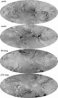
Meanwhile, I have been experimenting with some new map projections for Itokawa and other elongated objects. This is a Morphographic Equidistant (that's like an azimuthal equidistant, except it uses the local radius everywhere in the equations, instead of a constant radius) version of the Itokawa mosaic projected onto an ellipse. The ellipse was originally scaled for Ida, not Itokawa, but it gives a pretty good interim result. Versions with grids will follow later. Phil
-------------------- ... because the Solar System ain't gonna map itself.
Also to be found posting similar content on https://mastodon.social/@PhilStooke Maps for download (free PD: https://upload.wikimedia.org/wikipedia/comm...Cartography.pdf NOTE: everything created by me which I post on UMSF is considered to be in the public domain (NOT CC, public domain) |
|
 |
 
|
|
|
May 29 2012, 09:26 PM
Post
#32
|
|
|
Member Group: Members Posts: 140 Joined: 20-November 07 Member No.: 3967 |
. . . new map projections for Itokawa and other elongated objects. This is a Morphographic Equidistant (that's like an azimuthal equidistant, except it uses the local radius everywhere in the equations, instead of a constant radius) version of the Itokawa mosaic projected onto an ellipse. So is each individual ellipse a map of Itokawa's complete surface? Or does it take two of these ellipses to make one complete world map? Four? Will be easy to tell when you plop on the grids, but for those of us who can't wait . . . |
|
|
|
|
May 29 2012, 09:30 PM
Post
#33
|
|
 Member Group: Members Posts: 655 Joined: 22-January 06 Member No.: 655 |
Very nice Phil!
Itokawa is a bewildering little world - often makes me wonder how many different combinations of rock/ice/gravity/collisional history are possible. Seems every new celestial body we see is subtly different. It's an amazing solar system in which we live. |
|
|
|
|
May 30 2012, 12:05 AM
Post
#34
|
|
|
Senior Member Group: Members Posts: 2082 Joined: 13-February 10 From: Ontario Member No.: 5221 |
The early solar system was like a blizzard of rock and dust; little wonder none of these snowflakes are identical!
|
|
|
|
|
May 30 2012, 01:59 AM
Post
#35
|
|
|
Solar System Cartographer Group: Members Posts: 10151 Joined: 5-April 05 From: Canada Member No.: 227 |
"So is each individual ellipse a map of Itokawa's complete surface? Or does it take two of these ellipses to make one complete world map? Four?"
Each of these maps is of a 'hemisphere'. They are labelled north and south, or centered on longitudes 90 and 270 (with 0 degrees at one end). So although it might look like the common Mollweide projection (which maps 360 degrees of longitude into an ellipse) it is not. Two of these maps cover the whole body, and I'm mapping it here in two different ways with the poles or the equator at the middle. Phil -------------------- ... because the Solar System ain't gonna map itself.
Also to be found posting similar content on https://mastodon.social/@PhilStooke Maps for download (free PD: https://upload.wikimedia.org/wikipedia/comm...Cartography.pdf NOTE: everything created by me which I post on UMSF is considered to be in the public domain (NOT CC, public domain) |
|
|
|
|
May 30 2012, 02:05 AM
Post
#36
|
|
|
Member Group: Members Posts: 140 Joined: 20-November 07 Member No.: 3967 |
Each of these maps is of a 'hemisphere' . . . Two of these maps cover the whole body, and I'm mapping it here in two different ways with the poles or the equator at the middle.
Okay. But, sorry to be dense, which ones together? The two polar ellipses combine to make one complete map of Itokawa, the poles in the middle of each respective ellipse, and the two "other" ellipses combining to make another complete map of Itokawa, the equator running along each ellipse's long axis? |
|
|
|
|
May 30 2012, 11:42 AM
Post
#37
|
|
|
Solar System Cartographer Group: Members Posts: 10151 Joined: 5-April 05 From: Canada Member No.: 227 |
That's exactly right, Chuck.
Phil -------------------- ... because the Solar System ain't gonna map itself.
Also to be found posting similar content on https://mastodon.social/@PhilStooke Maps for download (free PD: https://upload.wikimedia.org/wikipedia/comm...Cartography.pdf NOTE: everything created by me which I post on UMSF is considered to be in the public domain (NOT CC, public domain) |
|
|
|
|
May 30 2012, 01:57 PM
Post
#38
|
|
|
Member Group: Members Posts: 140 Joined: 20-November 07 Member No.: 3967 |
That's exactly right, Chuck.
Phil Good. Thank you. Seeing no gap between the two pairs was confusing me. My architectural eyes were trying to imagine four orthographic (boxlike) views. Now, (Sorry not to have put the whole idea in one post), it looks like the contact spot of two (paired) ellipses is a point common to both hemispheres. Can you nudge the two ellipses together, creating a little overlap, a shared, central region? Seems like this might work for a distance of, say, the middle third. If not the middle half. Not that I don't like them this way! They're fun to cut out and fold together into elliptical Itokawa "coins." |
|
|
|
|
May 30 2012, 02:18 PM
Post
#39
|
|
|
Solar System Cartographer Group: Members Posts: 10151 Joined: 5-April 05 From: Canada Member No.: 227 |
"it looks like the contact spot of two (paired) ellipses is a point common to both hemispheres."
That's true of the top two, which align perfectly at the equator. Those two could be cut out and rolled around their perimeters to make a common point anywhere you liked. It's not true of the two equatorial views (as I have aligned them) - they are both north-up so the south pole of one touches the north pole of the other. But you can cut them out on a print or digitally and move them into any position you like where their edges would align at a common point. As for the overlap question, it would work for a very narrow central vertical strip but the projection distorts the surface away from there. Phil -------------------- ... because the Solar System ain't gonna map itself.
Also to be found posting similar content on https://mastodon.social/@PhilStooke Maps for download (free PD: https://upload.wikimedia.org/wikipedia/comm...Cartography.pdf NOTE: everything created by me which I post on UMSF is considered to be in the public domain (NOT CC, public domain) |
|
|
|
|
Jun 3 2012, 08:41 AM
Post
#40
|
|
|
Member Group: Members Posts: 890 Joined: 18-November 08 Member No.: 4489 |
---edit---
|
|
|
|
|
Jun 3 2012, 03:51 PM
Post
#41
|
|
|
Solar System Cartographer Group: Members Posts: 10151 Joined: 5-April 05 From: Canada Member No.: 227 |
Maybe for Itokawa it needs to be a brick-shaped map, a cuboid rather than a cube...
Phil -------------------- ... because the Solar System ain't gonna map itself.
Also to be found posting similar content on https://mastodon.social/@PhilStooke Maps for download (free PD: https://upload.wikimedia.org/wikipedia/comm...Cartography.pdf NOTE: everything created by me which I post on UMSF is considered to be in the public domain (NOT CC, public domain) |
|
|
|
|
May 24 2013, 03:58 AM
Post
#42
|
|
|
Solar System Cartographer Group: Members Posts: 10151 Joined: 5-April 05 From: Canada Member No.: 227 |
My photomosaic map of Itokawa is now available at the PDS Small Bodies Node (along with a shaded relief map of comet Wild-2, and all the previous maps as well)
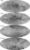
I have not yet got around to adding the grids to the elliptical maps above - I need to make some adjustments and I have not found the time yet. Phil http://sbn.psi.edu/pds/asteroid/MULTI_SA_M.../aamapdesc.html -------------------- ... because the Solar System ain't gonna map itself.
Also to be found posting similar content on https://mastodon.social/@PhilStooke Maps for download (free PD: https://upload.wikimedia.org/wikipedia/comm...Cartography.pdf NOTE: everything created by me which I post on UMSF is considered to be in the public domain (NOT CC, public domain) |
|
|
|
|
Apr 10 2014, 09:05 PM
Post
#43
|
||
|
Solar System Cartographer Group: Members Posts: 10151 Joined: 5-April 05 From: Canada Member No.: 227 |
Resurrecting an old thread here to post what I said I would post ages ago. This is the Itokawa mosaic projected into a triaxial (best fit) ellipsoid, mapped in the Morphographic (modified azimuthal) equidistant projection, with added grid lines. Low res version for now, but a better version will follow in PDS.
Phil
-------------------- ... because the Solar System ain't gonna map itself.
Also to be found posting similar content on https://mastodon.social/@PhilStooke Maps for download (free PD: https://upload.wikimedia.org/wikipedia/comm...Cartography.pdf NOTE: everything created by me which I post on UMSF is considered to be in the public domain (NOT CC, public domain) |
|
|
|
|
|
|
Apr 10 2014, 09:06 PM
Post
#44
|
||
|
Solar System Cartographer Group: Members Posts: 10151 Joined: 5-April 05 From: Canada Member No.: 227 |
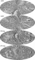
And... for comparison, though it doesn't really belong here, the same for Eros.
Phil
-------------------- ... because the Solar System ain't gonna map itself.
Also to be found posting similar content on https://mastodon.social/@PhilStooke Maps for download (free PD: https://upload.wikimedia.org/wikipedia/comm...Cartography.pdf NOTE: everything created by me which I post on UMSF is considered to be in the public domain (NOT CC, public domain) |
|
|
|
|
|
|
Sep 3 2014, 06:19 PM
Post
#45
|
||
|
Solar System Cartographer Group: Members Posts: 10151 Joined: 5-April 05 From: Canada Member No.: 227 |
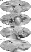
Another asteroid map comparison - no, it doesn't really belong here, but there's nowhere else right now and it does follow on from the last two posts here.This is 243 Ida, imaged by Galileo, mapped onto an ellipsoid which has been only roughly scaled to approximate Ida. This is a demonstration project rather than a highly accurate map, but it does illustrate what can be done with very elongated objects now.
Phil
-------------------- ... because the Solar System ain't gonna map itself.
Also to be found posting similar content on https://mastodon.social/@PhilStooke Maps for download (free PD: https://upload.wikimedia.org/wikipedia/comm...Cartography.pdf NOTE: everything created by me which I post on UMSF is considered to be in the public domain (NOT CC, public domain) |
|
|
|
|
|
|

|
Lo-Fi Version | Time is now: 26th April 2024 - 08:46 AM |
|
RULES AND GUIDELINES Please read the Forum Rules and Guidelines before posting. IMAGE COPYRIGHT |
OPINIONS AND MODERATION Opinions expressed on UnmannedSpaceflight.com are those of the individual posters and do not necessarily reflect the opinions of UnmannedSpaceflight.com or The Planetary Society. The all-volunteer UnmannedSpaceflight.com moderation team is wholly independent of The Planetary Society. The Planetary Society has no influence over decisions made by the UnmannedSpaceflight.com moderators. |
SUPPORT THE FORUM Unmannedspaceflight.com is funded by the Planetary Society. Please consider supporting our work and many other projects by donating to the Society or becoming a member. |
|