Printable Version of Topic
Click here to view this topic in its original format
Unmanned Spaceflight.com _ MSL _ MSL Post Landing - Commissioning Period & Early Observations
Posted by: elakdawalla Aug 14 2012, 06:24 PM
Now that Curiosity has her driving and science software installed and is ready to proceed, I figured it was time for a new thread. Please keep sol 0-8 discussion in the http://www.unmannedspaceflight.com/index.php?showtopic=7397&hl= (including discussion of the full-frame MARDIs, as they come down), and post new stuff here.
Things to look forward to: a Mastcam pan of the top of the mountain to be uplinked in the next sol or two; testing of the steering actuators on sol 13; first drive on sol 15. This period, which Grotzinger told me would take "no fewer than 6 sols," will be followed by an "Intermission," during which the science team may choose to drive to a new site (not very far away) for Commissioning Activity Period 2, when they'll commission the arm and its instruments.
Also, an admin note: we allowed a lot of chit-chat in the landing thread because we were all so excited about the successful landing  But as we move forward, I'd like to ask people to be mindful of http://www.unmannedspaceflight.com/index.php?act=boardrules. The strength of this forum is in its high signal-to-noise ratio; avoid posting things that just say "wow, awesome" or "I agree." Please keep chit-chat to the http://www.unmannedspaceflight.com/index.php?showforum=41.
Posted by: xflare Aug 14 2012, 06:56 PM
Will that Mountain Pan be with Mastcam 34 or 100 or both?
Posted by: Errol Coder Aug 14 2012, 07:25 PM
Do we know the extent of the pan? A narrow field of view capturing the peak and nearby foot hills, or a full sweep capturing edge to edge?
Posted by: craigmcg Aug 14 2012, 07:26 PM
As we look forward what will the bottlenecks to reaching the primary science target be? It seems there are a few:
- available power
- ability to get data back from the rover (limited number of overflights), one set of commands per day
- limited ability to operate autonomously
- "distractions" from other science targets
- wheel speed
Any others? Which one is the biggest limitation?
Posted by: RoverDriver Aug 14 2012, 07:31 PM
Anomalies. From my initial analysis it seems that the area is pretty benign both in terms of slopes and in terms of obstacles, therefore we will be able to drive "blind" most of the time and use autonav to extend the drives beyond what we can see. We don't have a good sense on how far we can drive per Sol yet.
Paolo
Posted by: jmknapp Aug 16 2012, 01:09 PM
Wow, some http://mars.jpl.nasa.gov/msl/multimedia/raw/?s=10&camera=NAV_RIGHT_A just came in from ChemCam and NAVCAM that were taken just 4 hours ago on sol 10 (that's to-sol). Curiosity and its relays firing on all cylinders.
Posted by: dshaffer Aug 16 2012, 04:25 PM

How do you get to the Sol 10 page from this basic link - it doesn't indicate any images beyond Sol 3?
http://mars.jpl.nasa.gov/msl/multimedia/raw/
Posted by: craigmcg Aug 16 2012, 04:31 PM
There is a link where you can view images by sol vs. by camera in the upper RH corner.
Posted by: Errol Coder Aug 16 2012, 04:58 PM
What are we looking at with the new ChemCam-RMI images? There seems to be circles passing before it? These some sort of filters or similar tech that it will end up using, or taken with the cap on?
Posted by: jmknapp Aug 16 2012, 05:08 PM
A boatload of images coming in right now--some beautiful mastcam shots from sol 3 (sure is a hazy place though) and about 90 MARDI shots of the ground under Curiosity right around the time of the landing.
Here's a link to my browser app right now, but bear in mind the list scrolls down as new images come in:
http://curiositymsl.com/index.php?limit=100&thumbsize=large
Posted by: djellison Aug 16 2012, 05:56 PM
Its calibration target.
http://www.msl-chemcam.com/index.php?menu=images_sup&rubrique=62&contact_page=images_sup&art=207
Posted by: elakdawalla Aug 16 2012, 06:35 PM
The Navcam images taken at the same time provide context. The Chemcam is located above the left Navcam, so look at the center of the left Navcam images and you'll see the Chemcam cal target.
Posted by: Astro0 Aug 17 2012, 12:12 AM
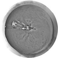
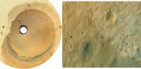
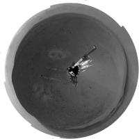
I know that this is obscure in terms of imagery, but here's the ChemCam Sol10 calibration target images (inset with flight spare). 

|
Posted by: stewjack Aug 17 2012, 04:05 PM
About an hour and a half to today's (Friday) Curiosity Rover Teleconference
I hope this information is correct. I am posting early just in case someone wants to correct me!
NASA To Host Curiosity Rover Teleconference Aug. 17
10:30 a.m. PDT (1:30 p.m. EDT, 1730 UTC), Friday, Aug. 17
Apparently it will NOT be on NASATV - it WILL be streamed on the Curiosity Cam Ustream channel
http://www.ustream.tv/nasajpl
Mission controllers at NASA's Jet Propulsion Laboratory in Pasadena, Calif., are checking out Curiosity's subsystems
and 10 instruments. Curiosity is in the opening days of a two-year mission to investigate whether conditions have been
favorable for microbial life and preserving clues in the rocks about possible past life.
Mission team members are "living" on Mars time. A Martian day is approximately 40 minutes longer than an Earth day,
meaning team members start their shift 40 minutes later each day. The scheduling of this teleconference and other Curiosity
media events is determined by their availability.
Visuals will be available at the start of the teleconference at: http://go.nasa.gov/curiositytelecon.
Posted by: djellison Aug 17 2012, 04:56 PM
The audio itself will be right here ; http://www.nasa.gov/news/media/newsaudio/index.html
Posted by: Explorer1 Aug 17 2012, 05:31 PM
Visuals are up. Very interesting...
EDIT: started....
Posted by: Drkskywxlt Aug 17 2012, 05:32 PM
Based on the imagery, looks like "Glenelg", where the 3 terrain units meet just east of Curiosity will be the first target.
Posted by: fredk Aug 17 2012, 05:37 PM
Also based on http://www.nasa.gov/mission_pages/msl/multimedia/pia16065b.html
Posted by: Drkskywxlt Aug 17 2012, 05:56 PM
John Grotzinger: "~1-1.5 months to get to Glenelg, ~1 month of science at Glenelg, ~end-of-the-year start drive to base of Mt. Sharp".
Posted by: OWW Aug 17 2012, 05:59 PM
1.5 months for a 500m drive? Isn't that a bit slow compared to MER?
Posted by: xflare Aug 17 2012, 06:02 PM
I thought I heard upto 2 months? I guess that includes possible science stops.
Posted by: Explorer1 Aug 17 2012, 06:04 PM
Yeah, Oppy at its best did that in a day or three. Of course the terrain there was even better, and they knew there were no science targets at all.
Posted by: Drkskywxlt Aug 17 2012, 06:07 PM
Neither MER was traveling 100m/sol for a long time after landing (not even during the primary mission IIRC). They're talking ~10m/sol, which will probably be (IMO) an average of some sols of stationary observations/science alternating with some sols of moderate, 10s of meters, driving.
Posted by: Paolo Aug 17 2012, 06:07 PM
I have lost a few sentences. do they plan to do anything at Goulburn Scour?
Posted by: Drkskywxlt Aug 17 2012, 06:10 PM
Imaging with all cameras and laser-blasting with Chemcam. That's probably it. They're worried about the drill being damaged on those rocks.
Posted by: charleski Aug 17 2012, 06:31 PM
Interesting that they will only be drilling after their first big review. The drill's their crown jewel and it looks like they're being really careful with it.
Posted by: Ondaweb Aug 17 2012, 06:40 PM
ChemCam is so cool. Roger implied they hoped to find out something about the composition of the "dessert varnish" that covers rocks on Mars (and Earth). I've wondered if Earth varnish has anything to do with bacteria. The 276K temperature recorded suggests a similar possibility on Mars may be possible (though, of course, highly unlikely.)
Posted by: charleski Aug 17 2012, 07:35 PM
Can the ChemCam wear out? I'm not sure if this is a silly question, but one of the replies in the Telecon seemed fairly specific in terms of the maximum number of pulses that they'd be using in the coming weeks. I looked through http://www.springerlink.com/content/12247284166x1871/fulltext.pdf and couldn't find any specific indication, but was interested to see that they were only allowed to fire 4500 pulses during the depth profile tests.
Posted by: mcaplinger Aug 17 2012, 07:46 PM
From http://www.lpi.usra.edu/meetings/lpsc2008/pdf/1500.pdf -- "However, the instrument was limited to 30 analyses per sol, realistic for its expected laser lifetime of ~20,000 analyses."
I'm not sure this applies to the flight unit but I would expect the laser to have some finite lifetime.
Posted by: Explorer1 Aug 17 2012, 07:47 PM
I'm wondering about the drill's longevity myself. I know Spirit's wore out a lot faster than Oppy's because of the difference in rock hardness, and so had to limit themselves to very interesting targets.
Will we have to wait until a drilling is done to see how much wear and tear it can take?
Posted by: climber Aug 17 2012, 07:50 PM
Will we have to wait until a drilling is done to see how much wear and tear it can take?
Listen to Emily here: http://www.planetary.org/blogs/emily-lakdawalla/2012/08151600-hangout-curiosity.html
They've got 2 more spare once the first one will be out

Edited: or read here: http://www.planetary.org/blogs/guest-blogs/20120816-limonadi-sampling-mars-1-tools.html
Posted by: Ondaweb Aug 17 2012, 08:05 PM
I heard this as referring to the design criteria, i.e., the minimum it should be able to do.
Posted by: akuo Aug 17 2012, 08:06 PM
I got the impression that they were not so much afraid of the drill getting damaged, but that the rock at the rocket impigment site wouldn't be good to drill into. It has been suggested that it may be duricrust. Would that be too fragile to get a good sample out of with the drill?
Also I think it was mentioned that the first sample to go into the labrotary kits would be dust or some other fines that is scoopable.
Posted by: elakdawalla Aug 17 2012, 08:18 PM
I think it's just not a good first sample to drill. They're going to want something that has a horizontal surface and that is a piece of rock that looks homogeneous, not a conglomerate of chunks of rock that may be more or less strongly cemented together by something else.
Posted by: craigmcg Aug 17 2012, 08:42 PM
Also sounded like we will be waiting a while before the photos of the top of Mt. Sharp will be takend and transmitted. Originally, I believe it was hoped to get them in during the past few days. (If my memory is correct?)
Posted by: Phil Stooke Aug 17 2012, 09:39 PM
Here's a circular version of the full navcam pan:
|
And this is the middle bit with labels to put our newest names into a more maplike perspective:
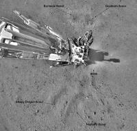
|
Phil
Posted by: djellison Aug 17 2012, 09:43 PM
The spares are not there because they worry the drill will wear out. They're there in case the drill gets stuck.
Posted by: fredk Aug 17 2012, 09:59 PM
Posted by: MahFL Aug 17 2012, 10:26 PM
The sun is in the south a lot, so they have to be super careful not to point at the sun with the normal filters. Also they seemed to indicate they wern't sure of the exposures needed. I am am sure Mike Malin will sort it all out.
Posted by: elakdawalla Aug 17 2012, 11:13 PM
There would be a Big Problem if ChemCam inadvertently pointed at the Sun. No more ChemCam.
Posted by: Joffan Aug 17 2012, 11:16 PM
If they really want to exercise the laser pointing, they should try writing "JPL" on N165. It's basically the landing reference, so a little commemorative grafitti seems in order.
My suggested name for N165: Zero Pebble.
Posted by: djellison Aug 17 2012, 11:26 PM
Yeah- there are some serious flight rules about sun-pointing the mast. You can do it for a few minutes, but then you have to turn away and let the ChemCam unit cool down. It's a big-ol reflecting telescope in there , and even at 1.5au - the sun can still do damage when you focus an area of its power.
Posted by: Tom Tamlyn Aug 17 2012, 11:29 PM
I'm not sure this applies to the flight unit but I would expect the laser to have some finite lifetime.
At approximately 11:30 in today's press conference, Roger Wiens, ChemCam principal investigator, said that ChemCam's "benchmark qualification" was the ability to do 14,000 analyses.
You can replay the press conference on ustream http://www.ustream.tv/recorded/24773693.
I have to say that it took me a little bit of googling to find the replay website. A reference to that url on the media announcements would have been helpful, or even just a mention that the replay would be hosted on ustream.
TTT (It's probably a sign that I'm past my "sell by" date, but ustream is not a site that's in my brain's short-term RAM, or a term that I would have thought to have included in searching for NASA press conferences. Of course I know better now, but still ....)
Posted by: elakdawalla Aug 17 2012, 11:41 PM
Recording teleconferences to UStream is brand new for JPL. They've streamed TV conferences there for a long time, but the audio-only ones are a new thing.
Posted by: mcaplinger Aug 18 2012, 12:15 AM
We're in the southern hemisphere, so the sun is in the north a lot. Maybe that's what you meant? Playing with Mars24 is instructive.
AFAIK sun avoidance shouldn't be a huge factor in imaging the summit, though it does have to be checked.
Some of us would appreciate it if you said "MSSS will sort it all out" instead of ascribing the entire operation of the instrument to one person
Posted by: xflare Aug 18 2012, 07:56 AM
Im trying to imagine sunrise with Mastcam100

Posted by: Stu Aug 18 2012, 10:59 AM
I'm not sure we'll ever see it. I hope I'm wrong, but looking at it with Google Mars, I rather think that the actual summit will always be hidden from Curiosity's view by the lie of the land. Once she starts her ascent of Mt Sharp, heading for the light toned unit, the peak will be over the top of what she can see. So we might never get to see Mt Sharp as a mountain.
Posted by: Roby72 Aug 18 2012, 11:16 AM
Regarding the REMS instrument, Grotzinger says yesterday in the press conference, it it is the first measurement of temperature since Viking back in 1982, but I´m not sure about that.
I think the Phoenix lander has its own canadian built weather station onboard and it could measure temperature as well.
Pathfinder - i dont know.
Rob
Posted by: Drkskywxlt Aug 18 2012, 11:50 AM
I think he was about to say that, but then caught himself and said "longterm" measurement. You're right, both Phoenix and Pathfinder had weather monitoring, but both only lasted a short time relative to the ~3 Mars years for Viking 1. REMS will be the first series comparable to that.
Posted by: climber Aug 18 2012, 12:25 PM
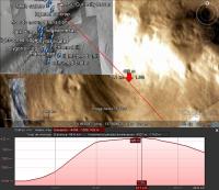
Stu (and all), can you please point out what you think will hidden our view?I'm trying to find the maximum altitude we'll see in order to match this with a similar view on Earth. It is actully difficult to find a view with ~ 5500m altitude difference, so if the real difference is much less, it'll make search easier and comparison real.
Posted by: Tesheiner Aug 18 2012, 01:12 PM
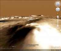
I know the altitude data on Google Earth are very coarse but, just completing what Stu already said, here's a vertical profile of a line directly connecting the landing site to the summit and showing that it is out of the line of sight (should we call it "Hidden Peak"?).
|
Posted by: Stu Aug 18 2012, 02:06 PM
Written about this on my blog, if you'd like to take a look...
http://galegazette.wordpress.com/2012/08/18/making-plans
Posted by: Stu Aug 18 2012, 02:16 PM
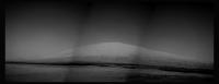
New pics down... first 'proper' view of Mt Sharp... (well, the front of it anyway! )
|
Posted by: Phil Stooke Aug 18 2012, 02:44 PM
Here's a processed view of the mountain.
Phil
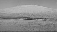
|
Posted by: fredk Aug 18 2012, 03:01 PM
And here's an average of L and R frames, which has reduced jpeg noise quite a bit (I had to rotate and scale one frame to register them well):
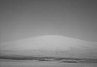
|
Enhance/mosaic as you see fit!
Posted by: Errol Coder Aug 18 2012, 03:38 PM
PS is giving issues with panorama blending, so here is my best shot with subtle enhancement and matching of layers for the full 3 frame composite.

|
Posted by: elakdawalla Aug 18 2012, 03:49 PM
My version. It's been a while since I did my own Mars rover image processing!
https://planetary.s3.amazonaws.com/assets/z_test/mars_msl_sol12nav_3frame_mtsharp_lakdawalla_NLA_398561738EDR_F0030004NCAM00400M.jpg
Posted by: SteveM Aug 18 2012, 03:58 PM
Very nice job of nursing good detail out of 7-bit data with JPEG artifacts.
Steve M
Posted by: Stu Aug 18 2012, 04:01 PM
Very nice, Emily, easily best yet
Posted by: Explorer1 Aug 18 2012, 05:36 PM
http://mars.jpl.nasa.gov/msl-raw-images/proj/msl/redops/ods/surface/sol/00012/opgs/edr/ccam/CR0_398560983EDR_F0030004CCAM03012M_.JPG
I'll bet the laser turns on pretty soon now....
Posted by: climber Aug 18 2012, 05:36 PM
Thanks all for you input.
I think the best equivalent picture will be of Mauna Loa or Mauna Kea in Hawaii at a distance of about 20km from the summit. The altitude (~ 4000m) would be about right.
I'll try to find that and see how it compares. Any better idea welcomed.
climber

Posted by: djellison Aug 18 2012, 06:10 PM
It's just like any other mountain - you very rarely see the absolute summit till you're on it.
Posted by: fredk Aug 18 2012, 06:20 PM
I thought that the true summit was farther south, more or less dead centre in Gale:
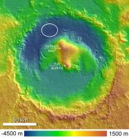
|
This elevation map and GM seem to agree that that's the highest point. Your summit corresponds to the "northern spur".
Either way, both "local maxima" will likely remain out of sight for a very long time. Although the "true summit" is sharper, so it might be easier to see from afar...
Posted by: Stu Aug 18 2012, 06:33 PM
That's what I'm going by, too...
|
Posted by: Tesheiner Aug 18 2012, 07:08 PM
Yeah, I was afraid of that.
As mentioned before, we need something as a sort of scale to give an idea of the size / distance: Liberty Statue, Eiffel Tower, Burj Dubai.
Posted by: James Sorenson Aug 18 2012, 07:47 PM
Ladies and Gentlemen....Mount Sharp from Navcam!

|
Ahh drats...Was already beatin to it.
Posted by: Stu Aug 18 2012, 07:51 PM
Where have you been? We got here hours ago!

Lovely image James.
Posted by: elakdawalla Aug 18 2012, 07:55 PM
Ahh drats...Was already beatin to it.
Your sky is better than mine. I tried to remove vignetting with the filter in Photoshop but it was still imperfect, and the sky had a periodic darkening that I attempted to remove (with some but not complete success) with the dodge tool. How do you de-vignette the images?
Posted by: James Sorenson Aug 18 2012, 08:07 PM
Lovely image James.
Obviously not on this planet...

Thank you Stu
PTgui has an option for Vignetting Correction.
Posted by: djellison Aug 18 2012, 08:11 PM
It's been a long way, but we're here.

|
Posted by: elakdawalla Aug 18 2012, 08:30 PM
OK, that's terrific. Since this is obviously so easy for you, can you please do it in stereo?
Posted by: djellison Aug 18 2012, 08:43 PM
Filling in the sky's not worth it - but I think this works.
(You were not expecting that were you One thing they probably didn't think of was the MER heritage for Navcam...carries over to experience of us amateurs stitching those Navcam images for 8 years )

|
Posted by: Ant103 Aug 18 2012, 09:34 PM
First, thank you Emily for publishing on your blog Visits on my blog has rizing very fast 
Second, I've updated my full panoramic with the Sol 12 Navcam pics. So now, Mount Sharp is not blur
http://www.db-prods.net/blog/2012/08/18/le-site-de-curiosity-au-crater-gale-full-panoramique/
Posted by: dilo Aug 18 2012, 10:31 PM
Excellent job, Damien... charmant!
Posted by: antipode Aug 19 2012, 01:46 AM
OK, there's NO rigor on this, but I did want to raise the idea of comparing the scene of Mt Sharp with a terrestrial scene of similar vertical scale.
Here's a stock shot of Kilimanjaro, taken at I believe a roughly similar distance, side by side with a hasty colorised crop from Doug's post.
The scales here aren't identical, but I think comparing portions of the Mastcams when they arrive with terrestrial scenes of similar scale will be very useful. The scale of Mt Hadley was really hard to process with Apollo 15 (no trees, streams, buildings, haze, normal signs of erosion etc to compare it with), here we have an atmosphere, but its still hard to really get a feel from the scale of the scene.
P
Posted by: fredk Aug 19 2012, 02:49 AM
OK, the shy but welcoming mystery man has finally come out to great the new arival! And he brings with him several copies of a particular tower to help us get a sense of scale:

|
The tower is about a third of a km tall (324 m exactly), just like the real Eiffel tower. The closest tower is 2 km away, and the farthest two are about 70-75 km. For the highest visible point I used 20 km from Tesheiner's profile. The background is Ant's fantastic mosaic.
Posted by: nprev Aug 19 2012, 02:53 AM
Great to see MM again, and glad he brought his towers! Thanks, Fred!
Posted by: antipode Aug 19 2012, 03:21 AM
MASSIVE help. Thanks Fred!
p
Posted by: dvandorn Aug 19 2012, 03:34 AM
Thanks, Fred. The Mystery Man and les Tours Eiffel (I hope I didn't massacre that spelling too badly) give a truly fine sense of scale to the scene.
Which leads me to another thing that I've been wondering about ever since the first navcam pan came down. The rim of Gale is obviously a lot closer to the north and west than to the south and east, but as you look directly east, at the far rim wall and past the rising flank of Mt. Sharp, the rim (and even the rise of the lower mound) become very indistinct, as if there is an awful lot of haze in the air in that direction. The haze layer straight to the west only obscures perhaps the lower 20% of the rim, while it obscures the entire rim to the east.
I know this could simply be an artifact of sun angle and the angle through which we are looking at a relatively uniform haze layer. But it strikes me that this could be evidence of strong prevailing winds from the east that flow around the rim, kicking dust over the east rim that then slowly settles closer to the ground as it circulates around the crater.
I'll be interested in seeing images of the rim from higher up on the mound, at different times of day and also at different times of year.
-the other Doug
Posted by: climber Aug 19 2012, 09:37 AM
I LOVE the latest panoramas as well as Fred references.
Nevertheless, I'm a mountain guy and I can't get it right with what I see here (this is due to the widest angle of the camera as compared to human eyes) even if I think Antipode comparison is about right.
The highest point we can see on Mt Sharp is 4000m high and 20 kms away which give a visual angle of 11°5 (Fred correct me is I'm wrong).
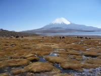
I include here a picture of Parinacota volcano (6348m) in Northern Chile I took at 4500m from 10 kms to the summit which give the same visual angle ~11.5°. Camera settings is 30mm comparable to Curiosity's.
I hope it'll help even if the moutain itself is a lot "sharper" specialy on the left hand side (while it looks like Mt Sharp on the right).
|
It's "Tour" without an "s" ODoug...
Posted by: climber Aug 19 2012, 09:47 AM
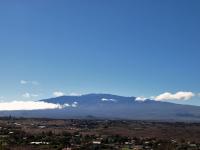
Well, this HAS to be much better. I Googled "Mauna Kea seen from Waimea" since there is a 4000m altitude difference and a 20km distance + a much better visuel match with Mt Sharp
|
Edited: note that we can see the observatories which give also a sense of scale
Camera Make : OLYMPUS IMAGING CORP.
Camera Model : E-510
Focal Length : 24 mm
Posted by: Stu Aug 19 2012, 09:50 AM
BRILLIANT! Thank you, that's mega helpful.
Posted by: Marz Aug 19 2012, 02:00 PM
According to the silly N165 twitter, the rover made a short drive and has begun firing the laser. I cannot find any substantial updates yet though. Assuming it's all working, this Sol is a huge commissioning checkout.
Posted by: Ondaweb Aug 19 2012, 02:00 PM
I find these pictures both very helpful and very distressing. No wonder it's going to take FOREVER to get to even the base of Sharp!
Posted by: JebbPA Aug 19 2012, 02:08 PM
Chemcam Sol 13 images are up! http://mars.jpl.nasa.gov/msl/multimedia/raw/?s=13&camera=CHEMCAM_RMI
Could this be a hole in n165: http://mars.jpl.nasa.gov/msl/multimedia/raw/?rawid=CR0_398646889EDR_T0030004CCAM06013M_&s=13 ?
hope so ; )
Posted by: malgar Aug 19 2012, 02:09 PM
Fantastic work! Could you add some other mystery men in the area in front of the closest tower? I mean between 0 and 2000m.
Thank you
Posted by: xflare Aug 19 2012, 02:13 PM
Is someone on the science team behind that twitter account?
Posted by: fredk Aug 19 2012, 03:50 PM
Thanks! I wanted to add more men but I found it hard to make identifications between the foreground and orbital views. Hopefully Glenelg will have more obvious features to match...
Posted by: elakdawalla Aug 19 2012, 04:38 PM
One thing they probably didn't think of was the MER heritage for Navcam...carries over to experience of us amateurs stitching those Navcam images for 8 years )Wondrous!
Regarding the chemcam stuff -- first of all, the Twitter account is not by a member of the science team. The "short drive" should've been a giveaway. In the first place, you wouldn't drive before ChemCamming; that would mess up your pointing. Second, we know the rover hasn't been driven yet; they still need to do actuator tests and their short bump before commanding anything intentional.
As far as the ChemCam images go, as far as I can tell, they are not of a lasered rock. Whenever you see a ChemCam image that you can't figure out, look for a corresponding Left Navcam image taken at the same time for context. The three different ChemCam images are related to Navcam images of a little rock; one of the rocket-blasted areas; and of a patch of soil.
Posted by: Stu Aug 19 2012, 05:25 PM
Processed views of the CC images...

|
Posted by: orgetorix Aug 19 2012, 05:31 PM
Apologies if this has been mentioned before, but regarding this image (also attached):
http://mars.jpl.nasa.gov/msl-raw-images/proj/msl/redops/ods/surface/sol/00013/opgs/edr/ncam/NRA_398646382EDR_F0030004NCAM15000M_.JPG
Looking in the lower-right quadrant of the lower-left quadrant: that roundel with the JPL logo on it: is this post-flight damage? Or was that scar there before launch?
Really enjoying seeing all the images, guys, thanks a ton!
--
jgb
|
Posted by: nprev Aug 19 2012, 05:34 PM
Looks like a dust smudge from the landing to me. Notice that there's a dust 'shadow' behind the disc itself on the beam.
Posted by: ugordan Aug 19 2012, 05:37 PM
Context for one of the ChemCam images:
|
http://mars.jpl.nasa.gov/msl/multimedia/raw/?rawid=CR0_398646222EDR_F0030004CCAM04013M_
http://mars.jpl.nasa.gov/msl/multimedia/raw/?rawid=0003ML0000129000E1_DXXX
Posted by: jmknapp Aug 19 2012, 06:17 PM
Thanks! do you happen to know which raw image(s) contain the first chemcam target N165? Space.com shows a http://www.space.com/17164-mars-rover-curiosity-laser-big-drive.html of mastcam images, but I can't find the corresponding image in the mastcam raws that have been released. Easy to overlook a little rock though.
EDIT: found it--it's in the upper left quadrant of this image:
http://mars.jpl.nasa.gov/msl-raw-images/msss/00003/mcam/0003ML0000114000E1_DXXX.jpg
Posted by: ugordan Aug 19 2012, 06:23 PM
As Emily already pointed out, I think neither of the 3 (newest) images actually show N165.
Posted by: Stu Aug 19 2012, 06:34 PM
http://mars.jpl.nasa.gov/msl-raw-images/msss/00003/mcam/0003ML0000114000E1_DXXX.jpg
Posted by: akuo Aug 19 2012, 07:12 PM
I think the Chemcam laser has fired. At least there seems to be a new spot on the calibration target.
Sol 12: http://mars.jpl.nasa.gov/msl-raw-images/proj/msl/redops/ods/surface/sol/00012/opgs/edr/ccam/CR0_398560124EDR_F0030004CCAM02012M_.JPG
Sol 13: http://mars.jpl.nasa.gov/msl-raw-images/proj/msl/redops/ods/surface/sol/00013/opgs/edr/ccam/CR0_398645989EDR_F0030004CCAM03013M_.JPG
So she shot herself :-P
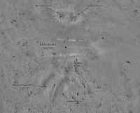
Posted by: Phil Stooke Aug 19 2012, 09:17 PM
Confirmed now - they shot N165 and renamed it Coronation, sol 13. Did we get a steering test?
Phil
Posted by: belleraphon1 Aug 19 2012, 09:58 PM
Chemcan did indeed....
http://www.jpl.nasa.gov/news/news.cfm?release=2012-248
"We got a great spectrum of Coronation -- lots of signal," said ChemCam Principal Investigator Roger Wiens of Los Alamos National Laboratory, N.M. "Our team is both thrilled and working hard, looking at the results. After eight years building the instrument, it's payoff time!"
ChemCam recorded spectra from the laser-induced spark at each of the 30 pulses.....
"It's surprising that the data are even better than we ever had during tests on Earth, in signal-to-noise ratio," said ChemCam Deputy Project Scientist Sylvestre Maurice of the Institut de Recherche en Astrophysique et Planetologie (IRAP) in Toulouse, France. "It's so rich, we can expect great science from investigating what might be thousands of targets with ChemCam in the next two years."
No word yet on steering test.
Craig
Posted by: MichaelJWP Aug 20 2012, 10:29 AM
Hi all - great forum and amazing resource; just de-lurked to ask a question, but also congrats to the whole MSL team for an amazing achievement and looking forward to all the science to follow.
Basically is there anywhere JPL posts a "sol-by-sol" list of what's planned in terms of surface operations for Curiosity for the next few sols?
Posted by: climber Aug 20 2012, 10:50 AM
Does somedody know if ChemCam was ever tested in a simulated Martian atmosphere? can't find any answer myself.
Posted by: pospa Aug 20 2012, 11:04 AM
Nope
It's not any damage. The background of JPL logo is our Sun (I guess) with planets on their orbits, see http://mediaarchive.ksc.nasa.gov/imageviewer.cfm?mediaid=55083&mr=l&w=0&h=0&fn=2011-5874&sn=KSC-2011-5874.
Posted by: jmknapp Aug 20 2012, 11:21 AM
The mother lode would be the http://www.nasa.gov/centers/ames/research/msl_operations.html software they use internally for mission planning:

|

|
Wouldn't hold my breath for that one though! It's interesting that that the Cassini mission puts their science plans on the public NAIF website, encoded as "event kernels." That's kind of rare & maybe a reflection of the old school. The data include when exactly each image/measurement will be taken and for what purpose.
Posted by: Lightning Aug 20 2012, 11:21 AM
Yes: http://www.dailymotion.com/video/xrmdgu_les-coulisses-de-la-mission-msl_tech#from=embed at the 34th second.
If you don't speak french, the gray "cannon" tube is where the Mars atmosphere is simulated (pressure, temperature and composition).
Posted by: Antonb Aug 20 2012, 11:47 AM
Hello everyone. My first post, so a brief introduction. A newbie poster here, but a daily reader and lifelong spaceflight fan. I still have all the newspapers I collected as a boy when any space-related item appeared, from Sputnik to the moon landings. At 13, when I saw the first Mariner photos of Mars, I was utterly convinced that one day I would go there myself and have a good look around.
Well, all these years have passed, I've travelled far and wide but and I never did make it to Mars. And yet, thanks to NASA, JPL, guys like you and the wonders of the internet, I have indeed been to Mars. In fact, I go there every day and have a good look around, just like I always wanted. Thanks to Stu's excellent "Road to Endeavour" blog, I've followed Oppy every step of the way of her epic journey, and now I'm soaking up every detail of the fantastic, fascinating landscape of Gale Crater.
Thank you, one and all. I am truly grateful.
OK, enough romantic hogwash, I'll stick to science now I've said hello.
Can anyone identify for me which mastcam raw image contains the target site of Glenelg? Using the following data I've walked the route on Google Mars and so I know the part of the panorama I should be looking at, but I'm uncertain as the exact location within a particular raw frame.
Curi: 4°35'22.15"S, 137°26'30.00"E
Glenelg: 4°35'24.00"S, 137°26'55.00"E (estimated)
Antonb
Posted by: pgrindrod Aug 20 2012, 12:00 PM
I'm not sure if this should be here or in the main landing thread (please move if necessary).
There was a bit of discussion about possible traverses. Well, of course, that'll depend on safety and science and we'll find out as we go along. But I thought I'd have a look at the relatively short (how times have changed!) drive of 400 m to the first drive target Glenelg.

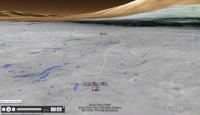
|
(larger version on my website http://petergrindrod.net/wp-content/uploads/2012/08/Gale-GIS-HiRISE-landing-site-traverse-eg.png)
It looks like a gentle drop of about 20 m, with manageable slopes all less than about 8 degrees. Of course, this is just an example traverse plot, but it looks ok.
For anybody interested, I wrote a blog http://www.petergrindrod.net/archives/858 about my thoughts on the geological context of the landing site, including more of this GIS stuff, and how it might all fit into the story of Mars.
Pete
Posted by: climber Aug 20 2012, 12:18 PM
If you don't speak french, the gray "cannon" tube is where the Mars atmosphere is simulated (pressure, temperature and composition).
Thanks! I AM French actually
...
Posted by: climber Aug 20 2012, 12:20 PM
I remember John Grotzinger saying 2m. Did I misunderstood?
Posted by: Antonb Aug 20 2012, 12:21 PM
Pete, that's really interesting reading, thanks. I note that you calculate Glenelg is probably not visible on the panorama, but is it possible for you to plot the visible parts of your example traverse onto the mastcam panorama?
Antonb
Posted by: MahFL Aug 20 2012, 12:47 PM
I am pretty sure he said 20 m.
Posted by: centsworth_II Aug 20 2012, 01:04 PM
Have you seen Phil Stooke's interpretation in http://www.unmannedspaceflight.com/index.php?s=&showtopic=7397&view=findpost&p=188822
|
Posted by: jmknapp Aug 20 2012, 01:06 PM
FWIW, the Google Mars view (based on a MOLA DEM I think) shows that Glenelg is below a rise in the foreground:
|
So Glenelg would be on a bit of a slope. Should be a good view from there, almost like looking down into a valley:

|
Posted by: charleski Aug 20 2012, 01:43 PM
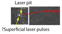
Set lasers to analyse!
They've done their first laser shot and posted a http://photojournal.jpl.nasa.gov/catalog/PIA16075 that's a differential of pre- and post-shot. Given that, I'm intrigued by the small scuff seen on the upper left of the pit. Roger Wiens was talking about their interest in seeing what the laser would reveal about rock coatings and surface interactions (34:53 in the http://www.ustream.tv/recorded/24773693) - did they scatter a few pulses off the main pit to take a look?
|
Posted by: Antonb Aug 20 2012, 02:50 PM
Yes, I saw that projection, which led me to believe the mastcam raw image containing Glenelg is http://mars.jpl.nasa.gov/msl-raw-images/msss/00003/mcam/0003ML0000023000E1_DXXX.jpg. I know Glenelg itself is hidden from Curi right now, but can anyone indicate the general area on this frame that we're heading for?
Thanks.
Posted by: jamescanvin Aug 20 2012, 02:51 PM
Looks like they imaged Mt Sharp with mastcam34 (and parts with mastcam100!) on sol 13. Thumbnails are avaiable.
http://mars.jpl.nasa.gov/msl/multimedia/raw/?s=13
Posted by: Pete B. Aug 20 2012, 02:57 PM
I thought at the time that he meant a 2m drop into the high TI terrain from the triple junction.
Posted by: climber Aug 20 2012, 03:01 PM
This makes more sense.
Posted by: Phil Stooke Aug 20 2012, 03:02 PM
Antonb, until Curiosity gets there and can see details of the outcrops, we won't be able to say exactly which spots will be explored. For now, just the area indicated on the JPL press release, will have to do, but you can assume that all three units in that area will be examined as well as careful imaging of the contacts to figure out the relationship between them.
Phil
Posted by: RoverDriver Aug 20 2012, 03:14 PM
It looks like a gentle drop of about 20 m, with manageable slopes all less than about 8 degrees. Of course, this is just an example traverse plot, but it looks ok.
...
The goal location of the first science target is about 50 m NW of where your end location is. At the tip of the flat featureless area which overlooks the "triple point". It is possible we will do a "drive by" next to the small bump East of the rover, more or less half way to Gleneleg. Slopes from the DEM seems to reach 10deg except at the bump.
Paolo
Posted by: xflare Aug 20 2012, 03:33 PM
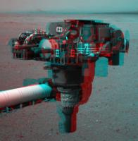
WOW they have deployed the robotic arm.
http://mars.jpl.nasa.gov/msl/multimedia/raw/?rawid=NLA_398742207EDR_T0030004NCAM00105M_&s=14
Posted by: fredk Aug 20 2012, 03:36 PM
Here's my interpretation of Paolo's proposed route description:
|
And my guess for the outlines of the three terrain types around Glenelg:

|
As people have pointed out, it looks like the actual junction is hidden by the foreground.
Posted by: Ant103 Aug 20 2012, 03:41 PM
http://mars.jpl.nasa.gov/msl/multimedia/raw/?s=13
Are you sure for Mastcam100 ? Because this camera is located at the Right side of the Mast, not the Left. And all I see is "L" in the filenames. Maybe it's just subframed pictures ?
Posted by: ugordan Aug 20 2012, 03:45 PM
Definitely. See http://mars.jpl.nasa.gov/msl/multimedia/raw/?rawid=0013MR0012007000I1_DXXX&s=13 for example.
Posted by: MahFL Aug 20 2012, 03:49 PM
They moved Curiosities arm.
Posted by: RoverDriver Aug 20 2012, 03:57 PM
|
|
And my guess for the outlines of the three terrain types around Glenelg:
|
|
As people have pointed out, it looks like the actual junction is hidden by the foreground.
Correct, except that I'm not sure how close we will be driving to the halfway point and how close to the overlook point. And you are correct, Gleneleg is not visible from here. Maybe if we stick up the arm and take a MAHLI but I doubt we would be seeing it anyway.
Paolo
Posted by: Ant103 Aug 20 2012, 04:02 PM
Okay ! I was checking the wrong "folder". Thanks
Posted by: chokai Aug 20 2012, 04:33 PM
Oh now that would be amusing, concert crowd style pictures..... All we need now is an oxygen atmosphere and a lighter.... More seriously would you really gain much height over the mast? If so how much are we looking at?
Posted by: elakdawalla Aug 20 2012, 04:53 PM
Not really. They use the teleconferences to do that. There are two scheduled this week, for tomorrow and Thursday. Watch them on JPL's ustream (ustream.tv/nasajpl)
Posted by: ChrisC Aug 20 2012, 05:47 PM
That was my interpretation as well.
Mount Sharp anaglyphs? Arm deploy? Laser pits?! Oh my god it's getting too exciting around here!
[grabs paper bag to breath into]
#PewPew !
Posted by: jmknapp Aug 20 2012, 06:27 PM
Has the rover moved? New hazcam view of Mt. Sharp:
http://mars.jpl.nasa.gov/msl-raw-images/proj/msl/redops/ods/surface/sol/00014/opgs/edr/fcam/FLA_398741806EDR_F0030004FHAZ00200M_.JPG
That image was taken about 5 hours ago, sol 14.
Posted by: MattB Aug 20 2012, 06:40 PM
Doesn't look like either the rover or the wheels moved.
Compare to Left Front Hazcam image from http://mars.jpl.nasa.gov/msl-raw-images/proj/msl/redops/ods/surface/sol/00000/opgs/edr/fcam/FLA_397506083EDR_F0010008AUT_04096M_.JPG.
Posted by: ddeerrff Aug 20 2012, 07:18 PM
Per http://www.space.com/17174-mars-rover-curiosity-first-drive-soon.html?utm_source=feedburner&utm_medium=feed&utm_campaign=Feed%3A+spaceheadlines+%28SPACE.com+Headline+Feed%29, should be steering actuator tests tosol, first movement sol 16.
Posted by: stevesliva Aug 20 2012, 07:25 PM
Nice, thanks!
Posted by: fredk Aug 20 2012, 07:37 PM
On the topic of picturing the height of the visible part of the mound, it's around 12 degrees above the true (level) horizon at its highest. Your outstretched fist is about 10 degrees wide:
It's very high in altitude above the floor of Gale, but it's also very far away, so the peak's not very high in the sky. This also shows how getting the sun into the camera's field of view was never a problem.
Posted by: charleski Aug 20 2012, 09:48 PM
Pete
I'm glad we'll be seeing some of the alluvial fan before heading off to the mound. But I'm still a little confused about the high TI unit. We're expecting it to be composed of clays formed from the finest particles that precipitated out as the influx petered out and dried up. But dry clay actually has a low thermal inertia - http://books.google.co.uk/books?id=Nr-Xgs6O0O0C&pg=PA606&lpg=PA606&dq=dry+clay+thermal+inertia&source=bl&ots=_LgsWADgFm&sig=Z56kf32B2hwXJXtnFRh-10DZqBs&sa=X&ei=HKwyUPbQGqSO4gTYg4GgAg&ved=0CEUQ6AEwCQ#v=onepage&q=dry%20clay%20thermal%20inertia&f=false list it as 550 Ws1/2m-2K-1 compared to dry sand at 590 and granite at 2200. Wet clay obviously has a much higher TI, but I don't think anyone's expecting this area to still be wet
. I'm not a geologist, so what am I missing here? Obviously this clay formed a long time ago, would it have undergone some form of alteration that changed its properties compared to fresh clay?[edit]
Actually, I got the impression that the real star of the EDL that allowed the ellipse to shrink so much was the novel guided entry manoeuvre using banking turns to achieve a precise flight path after the entry interface. The Skycrane got all the press because it's sexier
. Great blog post, summarises the objectives very clearly.
Posted by: RoverDriver Aug 21 2012, 12:00 AM
Actually, I got the impression that the real star of the EDL that allowed the ellipse to shrink so much was the novel guided entry manoeuvre using banking turns to achieve a precise flight path after the entry interface. The Skycrane got all the press because it's sexier
. Great blog post, summarises the objectives very clearly.You are correct.
Paolo
Posted by: fredk Aug 21 2012, 12:36 AM
http://mars.jpl.nasa.gov/msl/multimedia/images/?ImageID=4498 - jpl beat you guys to a thumbnail mosaic?
Posted by: JRehling Aug 21 2012, 05:31 AM
I'm a couple of days late on the discussion of imaging the top of Mt. Sharp... I wanted to add that while it's aesthetically nice to get the whole mound in one shot, the relative advantage of rover-imaging versus orbiter imaging declines dramatically for terrain nearer the summit. Not only is the rover relatively far away from the summit, but there is foreshortening in the Y dimension. And in addition, the top has some dust covering, and - as mentioned earlier - is one of the major surface units of comparatively least interest, and least probability of in situ analysis.
More science is always better, but the bottom half of Mt. Sharp is why Curiosity is in Gale. And no matter what Curiosity achieves, we'll end up with the best imaging of lots of Mt. Sharp's highest altitudes still coming from MRO and company up in orbit.
Posted by: ugordan Aug 21 2012, 08:16 AM
Full navcams of the arm are down:
http://mars.jpl.nasa.gov/msl/multimedia/raw/?rawid=NLA_398742207EDR_F0030004NCAM00105M_&s=14
http://mars.jpl.nasa.gov/msl/multimedia/raw/?rawid=NLA_398742240EDR_F0030004NCAM00105M_&s=14
Posted by: Cargo Cult Aug 21 2012, 08:44 AM
Haven't used Hugin in ages. Have a vague attempt at a stitch - I'm sure some much better ones will be along shortly!
https://hylobatidae.org/misc/msl-curiosity-arm-20120821.jpg (359KB JPEG)
Posted by: Ondaweb Aug 21 2012, 12:07 PM
CC, you may be rusty but that stitch is a lot better than the one with the press release. Is there something you did they didn't do, e.g., transform it in some way?
Posted by: jmknapp Aug 21 2012, 12:49 PM
So why might Curiosity be gazing at the sky, if I read this image from yesterday right:
http://mars.jpl.nasa.gov/msl-raw-images/proj/msl/redops/ods/surface/sol/00014/opgs/edr/ncam/NLA_398748045EDR_D0030004NCAM00502M_.JPG
There were a number of shots like that, taken about 18 seconds apart. Looks featureless, except for maybe a dust mote, star or somesuch at about xy 243,220 in all the images.
Posted by: MahFL Aug 21 2012, 12:53 PM
Tau measurements maybe ?
Posted by: Ant103 Aug 21 2012, 01:24 PM
Curiosity's arm fully unstowed. Might she take a portrait of herself with the MARDI MAHLI?
http://www.db-prods.net/marsroversimages/Curiosity/2012/Sol14_pano.jpg
Posted by: charleski Aug 21 2012, 01:49 PM
Nevermind, answered my own question: given sufficient compaction clay lithifies and this does indeed change its physical properties, becoming shale which has a higher thermal inertia, though still less than 80% of basalt. To reach a higher thermal inertia it would need to experience still more heat and pressure and metamorphose to slate, which has around 90% the TI of basalt. So the exact nature of the High TI Unit will probably give us an insight into how deeply the Gale floor was covered after the water dried up and how extensive the erosion has been.
Posted by: djellison Aug 21 2012, 01:50 PM
Looks like the old MERtian trick of cloud watching.
Posted by: climber Aug 21 2012, 02:13 PM
You mean MAHLI Damien because Mardi is...today
Posted by: djellison Aug 21 2012, 02:14 PM
You mean MAHLI.
There is hope to do a self portrait at some point in the future- but not yet.
Posted by: drz1111 Aug 21 2012, 02:44 PM
Even within the spectrum of what we'd call "shale", a rock can have had significantly different pressure/temperature/diagenitic histories. Butminerologists/petrologists and geochemists, armed with the analytical tools on Curiosity, can back out the T-P history of the rock from what they observe today (and what kind of fluids were involved in diagensis).
Posted by: 3d_mars Aug 21 2012, 02:48 PM
Possibly http://www.cyanogen.com/help/maximdl/Flat-Field_Frame_Calibration.htm.
Posted by: fredk Aug 21 2012, 02:51 PM
Exactly - nice to see something so familiar. They usually don't take that many flat field images, and they're usually full-frame. What looks like a DD sequence coming up, too.
Here's an anaglyph of the IDD - for experts mainly, since the stereo effect is pretty extreme:
|
Posted by: mcaplinger Aug 21 2012, 03:10 PM
FWIW, on MSL it's not called the IDD. I used to think it was called the SA/SPaH but technically that's not the name for the whole thing. We just call the thing in your anaglyph the turret, and we call the robotic arm (RA?) the arm.
It's worth remembering that when MSL was first described in the AO it had two arms, one for sampling and one for contact sensing, but those were merged.
Posted by: fredk Aug 21 2012, 03:20 PM
Thanks for that clarification!
Here's an animation showing dust particles leaving and new ones sticking onto the FRA lens. Must be some wind. First frame sol0, 2nd two sol 14:

|
I like the mast (RSM) rotating between the last two frames!
Posted by: Ant103 Aug 21 2012, 03:24 PM
Yes, sorry, MAHLI and not MARDI. Post corrected. Thanks
Posted by: EdTruthan Aug 21 2012, 04:46 PM
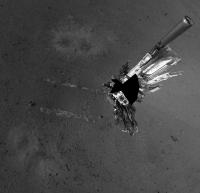
Goulburn Scour looks like it's been zapped!? The six very dark images that just came down from ChemCam, once brightened, features two nearly identical shots in which one show a distinct mark in the center on one of the hapless inhabitants of the scour. Here's animated GIF of the two frames and the location of the victim in question from mastcam. Poor fellow, first the descent stage, now this... just not his week.

|

|
Posted by: fredk Aug 21 2012, 04:52 PM
And wheel movement:
http://mars.jpl.nasa.gov/msl-raw-images/proj/msl/redops/ods/surface/sol/00015/opgs/edr/ncam/NLA_398830889EDR_F0030004NCAM00113M_.JPG
http://mars.jpl.nasa.gov/msl-raw-images/proj/msl/redops/ods/surface/sol/00015/opgs/edr/ncam/NLA_398831175EDR_F0030024NCAM00113M_.JPG
You can see the whole rover has shifted a bit as a result.
Posted by: Paolo Aug 21 2012, 05:00 PM
new audio teleconference in a couple of min
http://www.nasa.gov/mission_pages/msl/telecon/index.html: first wheel, arm movements, neutron instrument, meteo package
Posted by: Explorer1 Aug 21 2012, 05:05 PM
Starting now....
Posted by: MahFL Aug 21 2012, 05:08 PM
http://www.nasa.gov/mission_pages/msl/telecon/index.html: first wheel, arm movements, neutron instrument, meteo package
Wow, it's real windy, 25 m/s.
Posted by: dilo Aug 21 2012, 05:26 PM
What about 8% air humidity, is a lot! (or I misunderstood...)
Posted by: Explorer1 Aug 21 2012, 05:27 PM
Damaged wires on two wind sensor circuit boards...
Can't Mahli look at the mast? Maybe see exactly what happened?
dilo, that graphic is a place holder for the actual weather site.
Posted by: xflare Aug 21 2012, 05:29 PM
ughh journalists wont ask q's about anything else.
Posted by: Paolo Aug 21 2012, 05:31 PM
just confirmed at the teleconf
Posted by: Drkskywxlt Aug 21 2012, 05:32 PM
That stinks. This will probably make wind direction determination challenging.
Posted by: Hungry4info Aug 21 2012, 05:33 PM
Wind speed is given as an example. 25 m s-1 is not a real measurement. The clue was probably the 8% humidity...
Posted by: charleski Aug 21 2012, 06:43 PM
The http://www.nasa.gov/mission_pages/msl/multimedia/pia16080.html that show distinct repeatable notches in the cooling phase each day are apparently 'similar to predicated models'. Anyone have a source for those?
As far as the damaged wind transducer goes, it sounds like they have a fully-functioning backup on the other boom. So they might have to schedule in multiple readings each day with different mast rotations to nail down the direction, but will still be able to get accurate readings.
Posted by: jmknapp Aug 21 2012, 06:49 PM
With the latest navcam images:
http://mars.jpl.nasa.gov/msl-raw-images/proj/msl/redops/ods/surface/sol/00015/opgs/edr/ncam/NLA_398831207EDR_F0030028NCAM00113M_.JPG
...it looks like the wheels have turned, no?
EDIT; Sorry, behind the curve--just noticed in the http://www.nasa.gov/mission_pages/msl/telecon/index.html that they talked about this today.
Posted by: mcaplinger Aug 21 2012, 06:57 PM
REMS is on the part of the mast that doesn't rotate (below the azimuth actuator.) So this isn't possible.
http://msl-scicorner.jpl.nasa.gov/Instruments/REMS/
Posted by: MahFL Aug 21 2012, 08:09 PM
http://msl-scicorner.jpl.nasa.gov/Instruments/REMS/
The rover could rotate though
.
Posted by: djellison Aug 21 2012, 08:14 PM
And burn 600 Whrs just to heat up the mobility actuators to do so? Non starter.
They clearly said, repeatedly, in the press conference that this will just degrade the wind measurements. Not eliminate them or break them, just degredation when the functioning mast is in the wind 'shadow' of the mast.
Posted by: MahFL Aug 21 2012, 08:18 PM
They clearly said, repeatedly, in the press conference that this will just degrade the wind measurements. Not eliminate them or break them, just degredation when the functioning mast is in the wind 'shadow' of the mast.
I haven't heard the teleconference yet.
Posted by: RonJones Aug 21 2012, 08:27 PM
Anyone know how fast they will have the recording of today's telconference online (I was on the road and couldn't listen in real time)? I've seen the briefing slides at: http://www.nasa.gov/mission_pages/msl/telecon/index.html
Posted by: MahFL Aug 21 2012, 08:31 PM
It's up now.
http://www.ustream.tv/recorded/24867956
Posted by: RonJones Aug 21 2012, 10:47 PM
http://www.ustream.tv/recorded/24867956
Thanks I listened to the replay. I did notice that tomorrow (Wednesday) there will be a MSL news conference carried on NASA TV starting at 2:30 pm Eastern Daylight Time. They might have the results of the short first drive to report by then.
Posted by: Drkskywxlt Aug 21 2012, 11:09 PM
Those model predictions are here:
http://marsweather.com/covering-our-bets-on-the-pressure-prediction
Posted by: charleski Aug 22 2012, 12:34 AM
http://marsweather.com/covering-our-bets-on-the-pressure-prediction
Thanks - overall the pressure fluctuations agree extremely well with their global model (almost bang-on at 690-780Pa), but it's interesting to note that the static high-pressure component predicted in the mesoscale model doesn't seem to be present and the waveform seems heavily phase-distorted. Their model shows the plateau as the air cools, but I'm looking forward to what they say about those extra three inflections - I'll keep an eye on that blog.
Here's a quickie composite showing the model (in green), actual pressure readings in blue and the temperature in red.
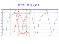
|
Posted by: Astro0 Aug 22 2012, 12:43 AM
There are so many fascinating things to look at around the landing site, it'll almost be a shame to leave.
Intrigued by the light-coloured material in this rock taken by ChemCam on Sol 15.
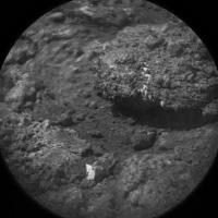
|
Posted by: dougr Aug 22 2012, 03:23 AM
The max air temperatures are significantly higher (>20F) than anything recorded by the Viking or Pathfinder landers. That surprises me a little since we are still quite a ways from perihelion. If I recall Pathfinder and Viking 1 landed at about 20N. Viking 2 at 48N. Curiosity sits at 4S. I wonder if this latitude difference suffices to explain this. What do the models say?
Edit: I just took a look at the above link to the mars weather page. The observations are maybe 5-10c higher than the models
Posted by: mcaplinger Aug 22 2012, 03:28 AM
By the way, if anyone hasn't read Dan Limonadi's guest blog on the Planetary Society website, he gives a very clear and detailed description of how the sampling system works on MSL. Definitely worth a read, Dan did an outstanding job. http://www.planetary.org/blogs/guest-blogs/20120816-limonadi-sampling-mars-1-tools.html is the first part.
Posted by: djellison Aug 22 2012, 06:09 AM
Agreed - SA-SPaH is breathtakingly complex and a beautiful piece of engineering - Dan does a great job of explaining it.
Posted by: JRehling Aug 22 2012, 08:38 AM
dougr, Viking lasted more than 1 martian year and it was in the tropics, so it was at some time at the subsolar latitude.
We've seen that temperatures on Mars can vary extremely sharply as a function of distance from the surface, with centimeters a relevant scale. So unlike on Earth, we have to take the comparison between two different systems with a grain of salt. Temperatures derived from IR reflectance as detected from orbit have shown temperatures far higher than any lander has detected, in part due to sampling the very hottest locations on the planet, in part due to measuring the surface and not the air a few decimeters above.
Posted by: chris Aug 22 2012, 09:34 AM
In relation to the wind sensors, extensive details of the REMS instruments are available http://ashimaresearch.com/wp-content/uploads/papers/REMS_paper.pdf
Edit: typo
Posted by: Stellingwerff Aug 22 2012, 09:45 AM
The top of MtSharp in full detail:
http://mars.jpl.nasa.gov/msl-raw-images/proj/msl/redops/ods/surface/sol/00015/opgs/edr/ncam/NLA_398828403EDR_F0030004NCAM00504M_.JPG
(actually: the top of the local part of the upper mount, the real top lies far back)
[Edit] Ah, too busy with the website to notice that there was already another round of similar pictures yestersol..... Sorry for spamming...
grz,
Ludo.
Posted by: Drkskywxlt Aug 22 2012, 12:17 PM
I think you misinterpreted the times or something. There's no (significant) phase distortion. Here's the REMS team's comparison:
http://marsweather.com/models-come-up-against-data
Posted by: ollopa Aug 22 2012, 01:08 PM
Anyone know the times of to-Sol's comms passes? Around now, I'm guessing.
Posted by: charleski Aug 22 2012, 01:44 PM
http://marsweather.com/models-come-up-against-data
The phase distortion is present in the model as well, but more pronounced in the actual data. Basically the peaks are broader and flatter than the troughs.
http://www.ndbc.noaa.gov/plot_met.php?station=42059&meas=pres&uom=E&time_diff=-4&time_label=AST an image showing air pressure changes in the Caribbean Sea as a weather pattern moves over - the diurnal changes are far closer to a sinusoid with amplitude modulation from the weather-front (http://www.wunderground.com/blog/JeffMasters/comment.html?entrynum=1883&page=13, image down the page in a comment).
http://mars.jpl.nasa.gov/MPF/science/pressure_movie.html found even more complex variations in pressure. Maybe the result of Curiosity being on a crater floor rather than an exposed plain.
I did get the scale of the model a bit wrong in the composite I posted. The graph on their page is correct.
Posted by: jmknapp Aug 22 2012, 02:26 PM
Check http://mslfan.com/2012/08/08/msl-almanac/
times UTC
3:21am ODY pass
3:37am MRO pass
3:44am earthrise
5:18am ODY pass
5:59am sunrise sol 16
6:23am MEX pass
9:47am earth zenith
12:06pm noon sol 16
12:17pm MEX pass
3:43pm MRO pass
3:49pm earthset
4:13pm ODY pass
6:13pm sunset sol 16
6:15pm ODY pass
The MRO pass coming up in about an hour (3:43pm UTC) is a very good one (times LMST):
zenith azimuth 269°, 03:37:37 P.M.
set azimuth 351°, 03:44:25 P.M.
min range 274 km
max elevation 79°
The calendar lists some marginal passes (i.e., even if the satellite only barely peeks above the horizon), so click through to get all the details.
I wonder if MEX has been used for downlinking at all yet. It's above the horizon for hours sometimes, so seems like there's a lot of potential.
Posted by: Ant103 Aug 22 2012, 03:29 PM
Sol 15 panoramic, showing a large piece of sky. I love this kind of view
http://www.db-prods.net/marsroversimages/Curiosity/2012/Sol15_pano.jpg
Posted by: djellison Aug 22 2012, 03:32 PM
http://blogs.esa.int/mex/2012/08/20/first-contact-mars-express-first-conversation-with-curiosity/
Posted by: Drkskywxlt Aug 22 2012, 03:38 PM
Ok, I think we're talking about different things. For a plot like that, typically in atmospheric science the "phase" is referring to the local time of the maximum (about 9am local solar time). The plot you posted looked like that phase was several hours off between obs and model.
I expect what you're seeing on some of the broadening of the maximum is due to atmospheric tides, although I don't know which one for sure without checking. You can see that quite clearly in the Pathfinder data. The curious sharp "notch" at ~2100 each day I can't explain off the top of my head...
Posted by: mars loon Aug 22 2012, 03:47 PM
here's our mosaic of Curiosity taking aim at Mount Sharp with her robotic arm; by Ken Kremer and Marco Di Lorenzo - kindly published at NBC News.com by Alan Boyle on Aug 22, 2012. It was the main photo on the front page top of NBC News.com overnight (see below)- still there as a smaller version now :
http://photoblog.nbcnews.com/_news/2012/08/21/13399924-curiosity-points-to-mars-destination

|
composite of navcams from sols 2, 12 and 14

|
Ken Kremer
....
kenkremer.com
Posted by: chris Aug 22 2012, 04:28 PM
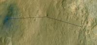
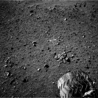
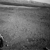
First drive images are down http://mars.jpl.nasa.gov/msl-raw-images/proj/msl/redops/ods/surface/sol/00016/opgs/edr/fcam/FLA_398919417EDR_F0030078FHAZ00302M_.JPG
Edit: replaced image with link
Posted by: Stu Aug 22 2012, 04:54 PM
Thanks to Paolo for agreeing to be email interviewed for my "Gale Gazette" blog...
http://galegazette.wordpress.com/2012/08/22/whats-it-like-to-drive-on-mars
Some very useful info and insights as usual Paolo, thanks!
Posted by: pmetschan Aug 22 2012, 05:05 PM
Looks like that rock was indeed under the wheel but looks like it was behind the left back as opposed to what I originally thought (under right back)
Did they do a complete 180 here? I'm a little bit confused on the rovers new orientation.
Posted by: Tesheiner Aug 22 2012, 06:17 PM
Here's a very crude navcam mosaic and a polar view.

|

|
Looks like a forward drive, followed by a 90-120deg. clockwise turn-in-place and a backwards move.
Posted by: Stu Aug 22 2012, 06:20 PM
Fantastic having the foothills of Mt Sharp in the same view too...
|
Posted by: Gsnorgathon Aug 22 2012, 06:27 PM
Looks like a forward drive, followed by a 90-120deg. clockwise turn-in-place and a backwards move.
90 degrees, according to yesterday's telecon.
Posted by: Joffan Aug 22 2012, 06:28 PM
Interesting to see the zigzag tread marks of Curiosity after so many years of the straight tread marks from Opportunity and Spirit. The morse slots come up less often than I expected.
Looks like very firm ground - although of course there was a lot of surface dust blown away during landing.
Posted by: Explorer1 Aug 22 2012, 06:30 PM
Conference starting now...
And Bradbury landing!
Posted by: dvandorn Aug 22 2012, 06:36 PM
And we are *tall*.
Great clip of Ray Bradbury from 1971.
-the other Doug
Posted by: dvandorn Aug 22 2012, 06:39 PM
I knew in advance I would see the very first tracks from MSL start from nowhere (so to speak), unlike any of the MER wheel tracks (which at their very beginning start from the edge of their landers). But it's still sort of eerie to see it.
-the other Doug
Posted by: Explorer1 Aug 22 2012, 06:50 PM
Could the initial hydrogen signal be from an invisible layer of frost? It is still technically winter at the site.
Posted by: Ant103 Aug 22 2012, 06:50 PM
Yihiii, we are roving Mars again ! Excellent ! And a new rover orientation now.
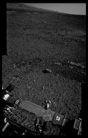
Sol 16 Navcam panoramic
http://www.db-prods.net/marsroversimages/curiosity.html#sol16
I just can't believe that these pictures were taken since about less than 4 hour on Mars. When I do some trail in mountains (like Pyrenees these times) I stitch my panoramic in about 1 or 2 days after they were taken
Posted by: dvandorn Aug 22 2012, 06:51 PM
And ChemCam is getting really good signal, great details in the spectra. It is wondrous to get this kind of information so quickly, no long integration times to slow us down with this instrument.
Will this tend to make some of the science stops along the traverse path a little shorter than we're used to with the MERs, I wonder?
-the other Doug
Posted by: Hungry4info Aug 22 2012, 07:00 PM
Time for a route map!
Posted by: Explorer1 Aug 22 2012, 07:01 PM
Well, there's still the APXS with its half-lives counting down. Eventually integration times will be affected like on Oppy.
Posted by: Tesheiner Aug 22 2012, 07:06 PM
It's a strange picture, indeed, the tracks starting from nowhere. Looks like the rover was teleported (ZAP!) to that place.
Posted by: 3d_mars Aug 22 2012, 07:25 PM
Hydrogen was also found on the calibration targets on the rover.
Posted by: fredk Aug 22 2012, 07:26 PM
|
I'd say this deserves the "postcard" treatment...
Posted by: pmetschan Aug 22 2012, 07:36 PM
-the other Doug
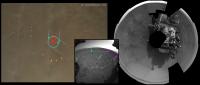
Ok here is an update of my MARDI map then. I am a bit confused about where those 2 rocks/mounds (Purple Arrows?) are then that appear in the post drive image, compared to the MARDI frame. What I am really attempting to do here is figure out "precisely" how big and in what orientation the rover was in (on that MARDI frame) post landing?
|
Posted by: akuo Aug 22 2012, 07:36 PM
It's the Mössbauer spectrometre on MERs that has the short (under a year) half-life. The APX's material's half-life is a lot longer, 18 years. That's hardly going to affect us at all.
Posted by: Paolo Aug 22 2012, 07:41 PM
hydrogen was only found on the first shots to Coronation, so it must be a very thin surficial layer. I was wondering: could this be contamination from hydrazine (N2H4) from the Skycrane exhausts?
Posted by: Doc Aug 22 2012, 08:03 PM
You'd expect N to be in the spectra too (is it?
 )
)
Posted by: Doc Aug 22 2012, 08:06 PM
'Bradbury Landing', how fitting! The future Martians ought to erect his statue there with plaque that should say 'from here she (Curiosity) took off'.
Posted by: Pando Aug 22 2012, 08:08 PM
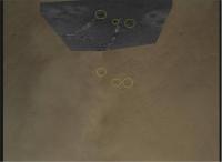
Here's a quick and dirty identification of features from MARDI image (frame # 545) with the image taken after the drive. It really gives a sense of height from which the MARDI image was taken.
|
Posted by: djellison Aug 22 2012, 08:14 PM
They turned 120 degrees to the right.
Posted by: djellison Aug 22 2012, 08:15 PM
You're confusing the APXS with the Mossbauer. The APXS doesn't suffer in the way the Mossbauer does ( at least, not on rover lifetime scales )
Posted by: Phil Stooke Aug 22 2012, 08:17 PM
A couple of goodies here:
|
|
Phil
Posted by: Pando Aug 22 2012, 08:37 PM
That's awesome, Phil. Here is your projection superimposed to the MARDI image.

|
Posted by: pmetschan Aug 22 2012, 08:48 PM
Here's an update based on your image, narrowing it down some more, does this look pretty close?

|
Posted by: Ron Hobbs Aug 22 2012, 09:08 PM
It kind of was... slung beneath a fire-breathing dragon.
Posted by: dmg Aug 22 2012, 09:10 PM
I didn't hear them say and have not otherwise seen whether the occurrence of this video press conference today cancels out tomorrow's previously planned audio conference or if that audio event is still on for 10:00 PDT Thursday. Does anyone know?
Posted by: Phil Stooke Aug 22 2012, 09:33 PM
"does this look pretty close?"
Bring your red arrow down 30% of the way towards your light blue arrow on the polar projection, to another nice little pair of rocks... and others accordingly.
Phil
|
Posted by: elakdawalla Aug 22 2012, 09:33 PM
Yes, as far as I know there is no briefing tomorrow. Thank goodness.
Posted by: Ondaweb Aug 23 2012, 12:06 AM
I just went to NASA TV to watch the replay of today's press conference. It started out playing it then switched to a replay of the landing. Any ideas where else I might find a replay of this press conference? I hate to miss one.
Posted by: dmg Aug 23 2012, 12:30 AM
See: http://www.ustream.tv/recorded/24889670
Posted by: MahFL Aug 23 2012, 12:31 AM
http://www.ustream.tv/recorded/24889670
This works ok for me.
Posted by: Ondaweb Aug 23 2012, 01:29 AM
Thank you both, it's working.
Posted by: jmknapp Aug 23 2012, 02:00 AM
Check out this paper:
http://ntrs.nasa.gov/archive/nasa/casi.ntrs.nasa.gov/19730006391_1973006391.pdf
In the final approach of the Viking lander on Mars, the retrorocket engine to be used is powered by a catalytic decomposition of hydrazine fuel to gaseous products by a stochiometrically undefined process of the type:
(2a+b)N2H4 -> 2aNH3 + (a+2b)H2 + (a+b)N2
It was estimated that at the landing site NH3, the major product, might reach fleeting concentrations of approximately 30 percent of the Martian CO2 atmosphere. In such an atmosphere, the reaction also generates aniline, hydrocyanic acid, and in all probability carbazic acid (H2NNHCOOH) and ammonium carbamate (NH4OOCNH2). Further work by Martin Marietta Corporation and others confirmed that the products depended on the grade of fuel used and the nature of the atmospheric environment. Purification of the "mil spec" hydrazine fuel lowered the yields of the decomposition side products, especially HCN. Nevertheless, it appeared that HCN at levels of 200-500 ppm might be encountered in the atmosphere at, and immediately surrounding, the Martian landing site. The possibility also exists that hydrazine fuel could contaminate the landing site by lander tank leakage, by unreacted N2H2 in the engine exhausts, or by the impact of the deorbit propulsion tanks with the aeroshell.
Maybe Curiosity oughta just mosey on? ;)
Posted by: stewjack Aug 23 2012, 02:53 AM
I expect this question will be answered as we mosey on.
Chemistry & Camera (ChemCam)
http://msl-scicorner.jpl.nasa.gov/Instruments/ChemCam/
Under Types of Investigations
3. Soil and pebble composition surveys. The ChemCam team plans to make a measurement of the soil near the rover each sol to document the range of soil compositions over which the rover traverses. These measurements may signal the presence of a new geological region, and will tell about the compositional similarity of the dust from place to place on Mars.
Posted by: 3d_mars Aug 23 2012, 05:29 AM
There appear to be parallel lines of pebbles that are very apparent when viewed in 3D. Both left and right images contain the same features. Does anyone else see what I'm trying to point out?
|
|
Posted by: Astro0 Aug 23 2012, 06:43 AM
My feeling is that this is an optical illusion akin to pareidolia.

|
Take a look at this image of random dots.
You will see dark and light lines running parallel, crossing, merging etc.
Yet they are completely random points.
As the rover moves, this scene will change and the lines will seem to follow another set of rocks.
I'm sure that someone with much better knowledge about these things will have a better explanation, but that's my take on it.
Posted by: Harder Aug 23 2012, 08:18 AM
Reading up on ChemCam as suggested by Stewjack: done. Also read the next item (APXS) and now I wonder: what is the specific scientific deliverable of APXS relative to what ChemCam will be able to do? It appears such an obvious question, both do elemental analysis after all, but I have not been able to google a document that clarifies this. Selection of payload is not a trivial matter so I'm sure I overlook something pretty important..
Posted by: ugordan Aug 23 2012, 09:10 AM
Couple of Mastcam-100 frames are down:
http://mars.jpl.nasa.gov/msl/multimedia/raw/?rawid=0013MR0012000000E1_DXXX&s=13
http://mars.jpl.nasa.gov/msl/multimedia/raw/?rawid=0013MR0012007000E1_DXXX&s=13
The rest, looking toward Mt. Sharp are blurred:
http://mars.jpl.nasa.gov/msl/multimedia/raw/?rawid=0013MR0014007000E1_DXXX&s=13
Posted by: MahFL Aug 23 2012, 09:12 AM
It was explained on the last news conference, APXS is more accurate, but ChemCam can sample many rocks pretty quickly but with good results, then they'd follow up with the other instruments on "interesting" targets.
Posted by: xflare Aug 23 2012, 09:42 AM
The rest, looking toward Mt. Sharp are blurred:
http://mars.jpl.nasa.gov/msl/multimedia/raw/?rawid=0013MR0014007000E1_DXXX&s=13
Parts of this one look sharper...I think http://mars.jpl.nasa.gov/msl-raw-images/msss/00013/mcam/0013MR0014013000D1_DXXX.jpg
Posted by: chris Aug 23 2012, 10:32 AM
http://mars.jpl.nasa.gov/msl/multimedia/raw/?rawid=0013MR0014007000E1_DXXX&s=13
I know the mastcams can focus, and have autofocus. I've looked, but I can't find any information about how the focus is controlled. Do we get an out
of focus image because the camera is commanded to take a picture but the autofocus is turned off? Or was the focus distance set from JPL but to a value
that meant the image is blurred?
Chris
Posted by: jmknapp Aug 23 2012, 11:13 AM
More background on possible landing site contamination:
http://books.google.com/books?id=EolLMX5gx4QC&pg=PA148&lpg=PA148&dq=aniline+hydrazine+mars&source=bl&ots=8oai22x65t&sig=RS-RsQyMa9AzF31O8uOSHpYpGqE&sa=X&ei=Zwk2UMa1CsPs0gG5xoDwAQ&ved=0CDEQ6AEwBQ#v=onepage&q=aniline%20hydrazine%20mars&f=false
The rocket exhaust study conducted for the Viking mission also addressed gas dissipation from the soil after landing (actually release and diffusion)... The Viking Molecular Team set as criterion that exhaust gas contamination at a concentration above 10ppm be permitted to exist for no more than 2 days after landing...
No subsequent comprehensive analyses for retrorocket contamination have been performed. The Viking assessment results have served as the ad hoc basis for all subsequent NASA soft-lander missions...
The [MSL] sky crane is expected to use hydrazine retrorockets as did Viking, but it may have throttled engines rather than pulsed engines, which would reduce potential disturbances of soil. Nonetheless, the sky crane will require larger loads of hydrazine propellant for their payloads (200 kg compared with 85 kg for Viking) and will at least temporarily contaminate the atmosphere surrounding the landing site.
Posted by: xflare Aug 23 2012, 11:29 AM
of focus image because the camera is commanded to take a picture but the autofocus is turned off? Or was the focus distance set from JPL but to a value
that meant the image is blurred?
Chris
Im sure that at last nights media briefing they said the mastcam 100 still had to be commissioned/tested properly, and these images were taken quite a few sols ago on sol 13.
Posted by: climber Aug 23 2012, 11:58 AM
Do you see several sort of land slides near the center? (no, I didn't say gullies)
Posted by: centsworth_II Aug 23 2012, 12:14 PM
You'll want to check out http://www.geochemsoc.org/publications/geochemicalnews/gn145jun11/chemcaminstrumentsuite.htm -- very informative.
"While ChemCam provides a large number of remote analyses, APXS, mounted on the rover arm, will provide a relatively smaller number of more accurate analyses.... ChemCam is sensitive to light elements and is highly sensitive to alkalis, APXS will have significantly better sensitivity for sulfur and halogens. As can be easily seen, these capabilities are highly complementary."
Posted by: chris Aug 23 2012, 12:41 PM
That makes sense. I'd still like to know how the focus and autofocus on the mastcams is controlled, though
Edit: typo & clarification
Posted by: Stu Aug 23 2012, 01:16 PM
Mt Sharp, colour...
|
|
Posted by: mcaplinger Aug 23 2012, 01:28 PM
Section 7.2, Focus, in http://rd.springer.com/article/10.1007/s11214-012-9910-4
of focus image because the camera is commanded to take a picture but the autofocus is turned off?
If the manual focus is set incorrectly, yes.
Posted by: algorimancer Aug 23 2012, 01:29 PM
Interesting. The lower layers are clearly horizontal, but the upper layers (at least those on the right side, and maybe the left) seem to be following the slope. Is this real, or an effect of erosion or perspective?
Posted by: belleraphon1 Aug 23 2012, 02:00 PM
Looks like the weather report for Sol 15 is real data.
http://cab.inta-csic.es/rems/marsweather.html
Craig
Posted by: RoverDriver Aug 23 2012, 02:01 PM
|
|
Malgar will definitely understand this since we are originally from the same place: Mt Sharp reminds me of a big "polenta" (corn meal).
Paolo
Posted by: chris Aug 23 2012, 02:05 PM
Thanks - very interesting.
Fascinating that the JPEG file size is used to determine the optimum focus point. I guess the mastcams are using something similar.
Posted by: ugordan Aug 23 2012, 02:12 PM
So you get images of Mt. Unsharp?
Posted by: elakdawalla Aug 23 2012, 02:41 PM
The successful first drive brings Cap 1B phase to a close at the end of sol 17, so http://www.unmannedspaceflight.com/index.php?showtopic=7426 Keep discussion of sol 9-17 activities here (including those Mt Sharp mastcams, whenever they come down), but for the play-by-play of daily activities, please move on to the new thread.
Posted by: fredk Aug 23 2012, 03:15 PM
Sol 13 mastcam anaglyph of Goulburn:

|
It's tough scaling/aligning the different cameras, so there may be some residual headaching...
Posted by: john_s Aug 23 2012, 03:17 PM
I think the lineations on the upper part are due to wind erosion, not primary layering- this is clearer in the orbital views.
John
Posted by: malgar Aug 23 2012, 03:22 PM
Paolo
LOL
Well, speaking about science to keep up the S/N of the forum, it's all about internal friction Now Paolo, take a look to http://www.unmannedspaceflight.com/index.php?s=&showtopic=7128&view=findpost&p=189574
Posted by: neo56 Aug 23 2012, 04:24 PM
Quick stitching of the Goulburn formation imaged by the Mastcam 100 during Sol 13.
http://orbitmars.futura-sciences.com/galerie_images/picture.php?/1426/category/curiosity
Posted by: Airbag Aug 23 2012, 05:27 PM
Some really clear colo(u)r images of the rover's deck from Sol 14:
http://mars.jpl.nasa.gov/msl-raw-images/msss/00014/mcam/0014ML0019000000E1_DXXX.jpg
http://mars.jpl.nasa.gov/msl-raw-images/msss/00014/mcam/0014ML0020000000E1_DXXX.jpg
http://mars.jpl.nasa.gov/msl-raw-images/msss/00014/mcam/0014ML0017000000E1_DXXX.jpg
Note the "floating" structures around the inlets; presumably they serve double duty as both wind guards and movement-compliant "docks" for CHIMRA?
Airbag
Posted by: djellison Aug 23 2012, 05:35 PM
They're just wind baffles. The CHIMRA outlet doesn't dock to it in any way - just gets might close.
Posted by: jmknapp Aug 23 2012, 06:32 PM
Finally found my red-blue glasses to check out some of the nice anaglyphs created by members here. Nice effects. Now I just wish there was a way to search for them by an "anaglyph" tag or some such. Or maybe a gallery page.
Here's a modest effort (just read a tutorial on how to do it in Photoshop) based on a MASTCAM 30/100 pair from sol 13.
http://mars.jpl.nasa.gov/msl-raw-images/msss/00013/mcam/0013MR0014012000D1_DXXX.jpg
http://mars.jpl.nasa.gov/msl-raw-images/msss/00013/mcam/0013ML0014012000D1_DXXX.jpg
|
Nice to see the basic effect in action--now to make it better.
Posted by: Antonb Aug 23 2012, 06:38 PM
Tweaked to enhance tone contrast and vertically exaggerated, this view suggests a horizontally banded sequence overlaid by a folded or recumbent syncline.
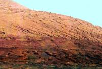
|
Posted by: john_s Aug 23 2012, 06:45 PM
Again, don't interpret the striations in the upper layer as necessarily original bedding- they are likely due to wind erosion. So I doubt we're seeing a syncline here, and certainly not a recumbent one (i.e., for non-geologists, a fold where one side is upside-down). If we are seeing original bedding, I'd interpret it as cross-bedding on massive scale.
John
Posted by: Gladstoner Aug 23 2012, 06:50 PM
.
Posted by: fredk Aug 23 2012, 07:17 PM
Unfortunately the mound is much too far away to see any stereo with mastcam. With careful aligning you can see that the L and R frames are indistinguishable. Here's my version of that anaglyph:

|
We can definitely expect some long-baseline stereo of the mound - they mentioned that at a recent press conference. I can't wait to see those!
Posted by: elakdawalla Aug 23 2012, 07:29 PM
An attempt at infrared false color of the recent Mastcam-100s of Goulburn Scour. There's no obvious indication of which images were taken through which filters, so I have no idea what wavelengths we're looking at here other than that they're infrared (which is why the images look grayscale: all three Bayer filters are mostly transparent to infrared wavelengths).
mcaplinger -- are the color Mastcams always shot in a particular order?
Larger https://planetary.s3.amazonaws.com/assets/z_test/mars_msl_sol13_goulburn_scour_false_color.jpg
Posted by: ugordan Aug 23 2012, 07:34 PM
That and the fact the cameras only return the grayscale image for such observations, IIRC.
Posted by: jmknapp Aug 23 2012, 08:03 PM
Interesting... I guess that's fake stereo in action. I tried it again with a pair closer up, also sol 13 (Goulburn):
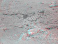
|
And with levels adjusted:
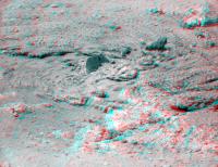
|
http://mars.jpl.nasa.gov/msl-raw-images/msss/00013/mcam/0013ML0012013000D1_DXXX.jpg
http://mars.jpl.nasa.gov/msl-raw-images/msss/00013/mcam/0013MR0012013000D1_DXXX.jpg
Yes?
Posted by: Stu Aug 23 2012, 08:40 PM
We'll see some sights when Curiosity starts driving through this lot, won't we..?
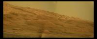
|
Posted by: mcaplinger Aug 23 2012, 08:42 PM
You might very well think they were shot in the same order as shown in http://www.redorbit.com/images/pic/63392/curiosity-rovers-mastcam/ -- I couldn't possibly comment.
Posted by: mcaplinger Aug 23 2012, 08:46 PM
Absolutely correct, even channels where the Bayer pattern isn't transparent, and which would otherwise be tinted (like the thumbnails) are sent in grayscale.
Posted by: mcaplinger Aug 23 2012, 09:03 PM
http://www.lpi.usra.edu/meetings/lpsc2012/pdf/2541.pdf at least describes the order of filters L0-L7 and R0-R7.
Posted by: Jaro_in_Montreal Aug 24 2012, 12:49 AM
Would anyone here happen to know roughly how deep the 0.4-millimeter hole in a typical basalt rock might be after 30 ChemCam laser shots ?
How is that likely to change for clay or sulfate minerals ?
Is there any risk of blowback of material from the hole into the ChemCam telescope ? ....is there a minimum distance to target to be respected ?
Thanks.
Posted by: atomoid Aug 24 2012, 12:57 AM
|
|
indeed! for those who havent stumbled on this yet, its a load of fun to 'preview' what this might look like from http://mars.jpl.nasa.gov/explore/freedrive/ (crank up the throttle at dashboard left)
Posted by: Gladstoner Aug 24 2012, 01:01 AM
.
Posted by: mars loon Aug 24 2012, 04:13 AM
Our Mastcam color mosaic of Mount Sharp now added to our wider Navcam mosaic of robotic arm pointing to mountain; by Ken Kremer and Marco Di Lorenzo
Published at NBC News.com; story by Alan Boyle - thank you ! - - includes mountain mosaics by Stu and mention of UMSF
"Curiosity adds color to Martian peak"
http://photoblog.nbcnews.com/_news/2012/08/23/13439494-curiosity-adds-color-to-martian-peak?lite
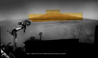
|
contrast enhanced to bring out detail - sol 2, 12, 13, 14 - Navcam and Mastcam raw images
Ken Kremer
........
kenkremer.com
Posted by: walfy Aug 24 2012, 07:06 AM
Destination: those distant hills! (After Glenelg, of course.) What a fantastic rolling landscape, which the anaglypgh captures a little here, like sea swells rolling in.
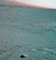
|
Posted by: walfy Aug 24 2012, 07:33 AM
Like the first moon step, as someone already mentioned. The first roll:
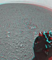
|
Looks a little more compressed where it landed.
Posted by: jmknapp Aug 24 2012, 11:54 AM
Curious to know how best to make stereo pairs from the mastcam images. The left image needs to be scaled and cropped to match the right--is using a constant scaling factor OK?
Mastcam 100 has been used for imaging some of the rover deck components but those are out of focus, presumably because the telephoto lens can't focus that close. Still, I tried an anaglyph of the sundial (sol 13, 12:42 p.m.) and it works to a first order, although the gnomon seems tilted toward the viewer:

|
It's interesting that the 3d effect comes out and appears fairly sharp even though the right eye is blurred.
Posted by: john_s Aug 24 2012, 01:51 PM
It's like the "monovision" contact lenses that some of us older folks have - different focus for each eye, but the brain can somehow combine the images and ignore the fact that one of them is out of focus.
John
Posted by: marsophile Aug 24 2012, 03:14 PM
At that distance and left/right lens separation, the brain expects the eyes to be pointing inwards. In this case, a cross-eye stereo pair would work better for depth perception. Or with the anaglyph, put one's eyes really close to the screen.
It is indeed very interesting that the brain can fuse the images in a way that takes the depth perception from both images and the sharpness from one image. In principle, an image-processing algorithm could do the same, i.e., use both images to construct the depth coordinate in a 3-dimensional rendering. Then map the left-eye pixels onto the 3D surface, and create a synthetic right eye view of the surface.
Posted by: fredk Aug 24 2012, 03:44 PM
http://mars.jpl.nasa.gov/msl-raw-images/msss/00013/mcam/0013ML0012002000D1_DXXX.jpg
http://mars.jpl.nasa.gov/msl-raw-images/msss/00013/mcam/0013MR0012002000D1_DXXX.jpg
The pointing hasn't changed, so I guess the L image must be cropped from the centre of the full L frame. If all L/R pairs are like this, then a constant scaling might be a good approximation. But if the L image is taken from off-centre, then the scaling will be somewhat different due to lens distortion.
Posted by: drz1111 Aug 24 2012, 04:29 PM
John
Wouldn't the wind erosion tend to follow bedding? That's what you see with hoodoos and other wind-eroded features on the CO Plateau . . . . I agree with your later post, however, that these are probably cross-beds if "real".
Posted by: fredk Aug 24 2012, 06:12 PM
I'll miss the simplicity of MER pancam. (Until I see the mound with mastcam 100, that is!)
Posted by: charleski Aug 24 2012, 07:03 PM
How is that likely to change for clay or sulfate minerals ?
Is there any risk of blowback of material from the hole into the ChemCam telescope ? ....is there a minimum distance to target to be respected ?
Thanks.
You might want to read http://www.springerlink.com/content/12247284166x1871/fulltext.pdf, which has a section where they test how deep the laser can penetrate. N165 was ~3m away and probably basalt, but they only used 30 pulses, so I'd guess it was a very shallow hole, maybe 50-100microns. The depth won't be linear with the number of pulses because as you get deeper more of the vapourised material will reform inside the hole. They did another test (Fig 27) which showed that it took over 10 pulses just to burn through a 25micron layer of dust.
The plasma ball that's created is really very small, even in Mars atmosphere, so I doubt there's any danger. I suppose theoretically there might be some hazard if there were a loose grain right next to the laser site, but I suspect the real limit on how close they can get is determined by the minimum focus distance of the optics.
Posted by: paraisosdelsistemasolar Aug 24 2012, 07:12 PM
Hi to everybody,
This is my first post in Unmanned Spaceflight and I wanted to say Hi in the first place and thanks for all your hard work analyzing all this data. Is incredible what we can achieve when we work together.
Second, answering climber question, I think the feature we are seeing near the center of the image are some kind of debris apron or fan, at least in the MRO images I can't see any evidence of landslides in that zone, so it's easier to think that this feature is just the effect of erosion and transportation of sediments.
Greetings!
Posted by: Jaro_in_Montreal Aug 24 2012, 09:00 PM
The plasma ball that's created is really very small, even in Mars atmosphere, so I doubt there's any danger. I suppose theoretically there might be some hazard if there were a loose grain right next to the laser site, but I suspect the real limit on how close they can get is determined by the minimum focus distance of the optics.
Thanks ! ...very interesting !
I also noted the following:
....which seems to imply that the first ChemCam test, with 30 pulses, was nowhere near the number of pulses that will be commonly used later on during the mission: I was under the false impression that 30 pulses was not that far from the maximum per target !
Posted by: atomoid Aug 24 2012, 10:09 PM
This seems to imply the laser will rarely make it past the modified 'rind' on the exterior of most rocks, and may be more suited for investigating clean RAT holes. unless im wrong and didnt study the MER results closely enough i thought the 'rind' has lots of modified compounds in it over eons of weathering, not necessarily endemic to the rock.. (no im not a geo-areologist )
EDIT:
ohkey, section 7,8,9 of http://www.springerlink.com/content/12247284166x1871/fulltext.pdf?MUD=MP do go into some detial about it, still seems shallow depth but enough appraently to make these statements:
...ability to remotely remove dust and to study and remove weathering layers from rocks...
Posted by: nprev Aug 24 2012, 10:47 PM
Nice part about that is the capability for before & after observations. Should prove illuminating either way.
Posted by: serpens Aug 26 2012, 02:45 AM
Can someone help me out with the weather report? I've not seen absolute humidity expressed as a percentage before. Is this the humidity ratio (mass of water/mass of air) - slightly more than 1 gram water vapor per m^3?
Posted by: MahFL Aug 26 2012, 03:46 AM
It's usually the amount of water the atmosphere can hold, 8 % is like a bone dry desert value, whereas in Florida eg, you often get 90 to 100 %, which generally feels miserable. Local met offices will also include a PWAT amount of water, that is if you squashed all the water out of the air you might eg get 1 inch. Usually less than 1/2 inch of PWAT it won't rain. Right now in NE FL the humidity is a nice 48 %. Most air conditioning units will make your house around 40 % humid, which is generally a comfortable level for humans.
Posted by: nprev Aug 26 2012, 05:29 AM
Interesting. I recall that many years ago (and, yeah, I'm getting old, no need to rub it in!) RH was always expressed as a percentage. Basically, 100% humidity meant it was gonna rain, period; the atmosphere was saturated.
Mars' atmosphere is both considerably less dense (approx. .01% of Earth sea-level) and radically different in composition than that of the Earth. The latter must have some effect on RH, but the low density is more significant: Liquid water cannot exist on the surface of Mars. Water there acts like dry ice on the Earth: two phases (solid or vapor), no waiting.
So, my read on 8% RH is that there must not be much water around, or at least the local conditions are not permitting significant sublimation. I'll be interested in the diurnal variation pattern if they do acquire such data.
Posted by: dvandorn Aug 26 2012, 06:04 AM
I recall reading that Mars' atmospheric humidity often reaches 100%, but that since the air is so much thinner and colder than Earth's, it can hold only a very small amount of water vapor, so that a very slight increase in the actual amount of water vapor in the air raises the percentage by a very large percentage.
So, it's relatively easy to saturate Mars' atmosphere in a given location with an overall very small amount of water vapor. A reading of less than 10% would, I would think, indicate an extremely dry air mass.
-the other Doug
Posted by: Paolo Aug 26 2012, 08:51 AM
I think you are referring to this recent paper http://www.sciencemag.org/content/333/6051/1868
Posted by: Deimos Aug 26 2012, 06:45 PM
>100% RH up in the sky is one thing. Frost and fog tell you that there's 100% at the surface with some frequency. The absolute amount is also greater than the saturation vapor pressure for night-time temperatures in many times & places. It's easy to saturate at -90 C. During the equatorial mid-afternoon though, 8% would be a dripping oasis by Martian standards. (But of course, in Tucson on an early July afternoon, 8% looks damp too.)
Posted by: ddeerrff Aug 27 2012, 02:34 AM
I always thought that 100% relative humidity was when the partial pressure of the water vapor in the atmosphere was equal to the vapor pressure of liquid water at a given temperature. As such, partial pressures of other gasses in the atmosphere would be irrelevant.
Posted by: serpens Aug 27 2012, 03:55 AM
Yeah, therein lies my query. Relative Humidity is a ratio (percentage), being the water vapor partial pressure to saturation vapor pressure. But the weather report provides the absolute humidity which I thought was the mass of water in a cubic metre of air? I am at a loss as to how to interperet absolute humidity as a percentage although, as with nprev, new methods may have overtaken my ageing knowledge base. If they mean the ratio of mass of water vapor to mass of air then the amount of water available for phase transition would seem really miniscule.
Posted by: Arkarch Aug 27 2012, 06:19 AM
http://www.google.com/search?q=coyote+buttes&rls=com.microsoft:en-us:IE-SearchBox&oe=&um=1&ie=UTF-8&hl=en&tbm=isch&source=og&sa=N&tab=wi&ei=c5c2UKq5M4So8QSJl4CYBQ&biw=1163&bih=763&sei=dpc2UKTZL5Gi8QSq2YDQBw#um=1&hl=en&rls=com.microsoft:en-us%3AIE-SearchBox&tbm=isch&sa=1&q=coyote+buttes+hoodoo&oq=coyote+buttes+hoodoo&gs_l=img.3...14384.16116.0.16272.7.7.0.0.0.0.78.376.7.7.0...0.0...1c.OZhlni34ZSE&bav=on.2,or.r_gc.r_pw.r_qf.&fp=8ce0fa10e7b56dc&biw=1163&bih=763
Just so long as Curiousity does not have to apply to the BLM permit lottery to visit that part of the mountain, I'm good with that
|
|
That is a remarkable view. Should be spectacular as climb through all that in stereo!
Posted by: 3d_mars Aug 27 2012, 02:43 PM
I'm sure you meant to say 1%
Posted by: marsophile Aug 27 2012, 05:57 PM
http://books.google.com/books?id=nWbmRj7YbUcC&pg=PA15&lpg=PA15&dq=%22percentage+absolute+humidity%22&source=bl&ots=DqicdTRj_1&sig=BDwSLcFX8EgmCAY7LaW_rxCGoEA&hl=en
Percentage absolute humidity.
It seems to be the ratio, expressed as a percentage, of the absolute humidity over what the absolute humidity would be if the atmosphere was saturated and at a particular temperature referred to as the "dry bulb" temperature. A complicated concept, but it appears to be independent of temperature and pressure. Not sure how it would apply to Mars.
[EDIT: The dry bulb temperature is not a specific temperature, it is the aiir temperature when the thermometer bulb is shielded from moisture and radiation. So now I am confused, because the definition would seem to be essentially the same as relative humidity.]
[EDIT2: Ah, some clarity. The only difference between relative humiidity and percentage absolute humidity is that the former is the ratio of the partial pressure to the saturated partial pressure whereas the latter is the ratio of the absolute humidity to the saturated absolute humidity. http://books.google.com/books?id=rWwzHsJ5GvYC&pg=PA223&lpg=PA223&dq=%22percentage+absolute+humidity%22&source=bl&ots=BuEAEqVkPA&sig=8YRsYihzNKtbsjGKNZYOR1TG0YE&hl=en]
Posted by: scalbers Aug 27 2012, 06:26 PM
Is this the link to the weather report with humidity?
http://cab.inta-csic.es/rems/marsweather.html
Here's a Wikipedia entry on absolute humidity, normally defined as a vapor density in grams per cubic meter. However there can be some confusion in terminology.
http://en.wikipedia.org/wiki/Humidity#Absolute_humidity
What are the units in the report? If it is percent, then maybe they really mean specific humidity (numerically almost the same as mixing ratio).
http://en.wikipedia.org/wiki/Humidity#Specific_humidity
It would be interesting to convert the reports to relative humidity, given that we know the temperature and pressure. By the way, relative humidity can be specified with respect to either water or ice, another fine point.
Posted by: serpens Aug 28 2012, 11:31 PM
All is explained. The Vaisala data sheet indicates that the probe measures relative humidity so this is probably no more than an descriptive error on the weather page.
Posted by: nprev Aug 29 2012, 09:32 AM
I did; was thinking 1/100th & wrote the wrong thing. Good catch, and thanks!
Posted by: craigmcg Aug 29 2012, 12:11 PM
This is true. Each compound (water, carbon dioxide, etc.) exerts it's own vapor pressure based on the temperature. At equilibrium, you add them up to get the total pressure.
Powered by Invision Power Board (http://www.invisionboard.com)
© Invision Power Services (http://www.invisionpower.com)