Jezero Delta Campaign, Sols 414-1000, 21 Apr 2022- 23 Dec 2023 |

  |
Jezero Delta Campaign, Sols 414-1000, 21 Apr 2022- 23 Dec 2023 |
 Apr 27 2022, 09:03 AM Apr 27 2022, 09:03 AM
Post
#31
|
|
 Senior Member  Group: Members Posts: 1619 Joined: 12-February 06 From: Bergerac - FR Member No.: 678 |
Thanks Phil
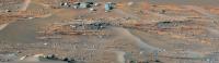
 Sol 420 Navcam panoramic. I really love this place, it's nice to finally see changes in the landscape.  Also deserved a Postcard : 
-------------------- |
 |
 
|
|
Apr 27 2022, 10:05 AM
Post
#32
|
||
|
Junior Member Group: Members Posts: 75 Joined: 8-July 15 Member No.: 7566 |
QUOTE (neville thompson @ Apr 26 2022, 09:16 PM)  Gigapan - PERSEVERANCE 419 -N © NASA/JPL-Caltech/MSSS/ASU/NeV-T I think this portion of your panorama might be our best view of Neretva Vallis yet. Neretva Vallis is the canyon cutting through the crater wall of Jezero Crater about 7 km to the NW, through which the river that formed the Jezero delta flowed. Once the rover drives ontop of the delta, we'll finally get to see an unobstructed view of the canyon which we'll be driving through in a year or two.
|
|
|
|
|
|
|
Apr 27 2022, 10:31 AM
Post
#33
|
|||
 Member Group: Members Posts: 664 Joined: 9-May 21 From: Germany Member No.: 9017 |
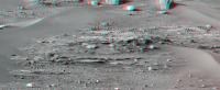
Sol 420 Supercam Remote Micro-Imager mosaic with sol 419 Navcam context
The mosaic shows the upper right corner of the sol 419 Mastcam-Z multispectral photo (see post #27), but from a slightly different perspective.
|
||
|
|
|
||
|
Apr 27 2022, 01:07 PM
Post
#34
|
|||
|
Member Group: Members Posts: 664 Joined: 9-May 21 From: Germany Member No.: 9017 |
Another sol 420 Supercam Remote Micro-Imager mosaic with sol 420 Mastcam-Z context
|
||
|
|
|
||
|
Apr 27 2022, 01:09 PM
Post
#35
|
|||
|
Newbie Group: Members Posts: 16 Joined: 27-February 22 Member No.: 9153 |
QUOTE (tau @ Apr 27 2022, 11:31 AM) Sol 420 Supercam Remote Micro-Imager mosaic with sol 419 Navcam context The mosaic shows the upper right corner of the sol 419 Mastcam-Z multispectral photo (see post #27), but from a slightly different perspective.
very nice view tau ! Distance: 310 m (rmi scale is 2.2 cm per pixel at 2000 m - source Dr. Gwénaël Caravaca) |
||
|
|
|
||
|
Apr 27 2022, 01:38 PM
Post
#36
|
|
 Member Group: Members Posts: 699 Joined: 3-December 04 From: Boulder, Colorado, USA Member No.: 117 |
QUOTE (tau @ Apr 27 2022, 06:07 AM) Another sol 420 Supercam Remote Micro-Imager mosaic with sol 420 Mastcam-Z context First closeup of the bedrock hereabouts. The texture looks like the Séítah rocks at first glance. But we may not have transitioned to the sub-delta layered unit yet. John |
|
|
|
|
Apr 27 2022, 05:23 PM
Post
#37
|
||
|
Member Group: Members Posts: 699 Joined: 3-December 04 From: Boulder, Colorado, USA Member No.: 117 |
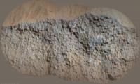
...aaand now we've transitioned to the layered unit:
|
|
|
|
|
|
|
Apr 27 2022, 06:51 PM
Post
#38
|
|
 Member Group: Members Posts: 684 Joined: 24-July 15 Member No.: 7619 |
QUOTE (neville thompson @ Apr 27 2022, 02:38 AM) Wow, amazing shot. Definitely should be "Jakku lithofacies" due to the resemblance to fictional planet covered in crashed star destroyers... |
|
|
|
|
Apr 28 2022, 03:34 AM
Post
#39
|
||
|
Solar System Cartographer Group: Members Posts: 10151 Joined: 5-April 05 From: Canada Member No.: 227 |
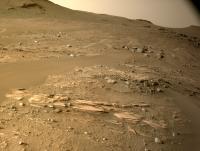
Sol 421, circular panorama with some nice outcrops between the aeolian ridges.
Phil
-------------------- ... because the Solar System ain't gonna map itself.
Also to be found posting similar content on https://mastodon.social/@PhilStooke Maps for download (free PD: https://upload.wikimedia.org/wikipedia/comm...Cartography.pdf NOTE: everything created by me which I post on UMSF is considered to be in the public domain (NOT CC, public domain) |
|
|
|
|
|
|
Apr 28 2022, 08:57 AM
Post
#40
|
||
|
Junior Member Group: Members Posts: 75 Joined: 8-July 15 Member No.: 7566 |
I concur with john_s. The rocks on Sol 420, best seen in Ant103's panorama, in my opinion look like the igneous rocks we saw earlier. Their colour, texture, and subdued relief reminds me of the upper Maaz formation members encountered early in the mission, remember the first failed coring attempt? Meanwhile the Sol 421 lithology is very different and is all consistent with prodelta mudstones, which must be an exciting moment for the mission's geologists.
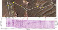
That means sometime in the last drive, the rover crossed the geological contact between the two units. On the surface, this contact may not have been spotted, as the area is covered in sand ripples and the contact is between two quite soft rock types. However, perhaps they've detected the contact in the subsurface using Rimfax, the radar instrument. In fact, the last two drives look very well suited for doing such a radar survey: the rover pivoted northwards and has conducted a nearly straight, N-S transect across the boundary, so I expect that's what they're doing right now. The rover did this same thing the last time it crossed a major boundary, when it entered the Seitah Formation around Sol 200 (see image for the results of that survey). I wonder if this was a major motivation for the rover planners choosing to come here in the first place instead of going to Hawksbill Gap: because this area better preserves the contact between the delta and the lava flow, allowing them to do a transect & Rimfax survey.
|
|
|
|
|
|
|
Apr 28 2022, 12:41 PM
Post
#41
|
|
|
Senior Member Group: Members Posts: 1043 Joined: 17-February 09 Member No.: 4605 |
Given the step back of the delta and what appears to be a contact between the effusive lava and sedimentary deposits I feel the layered unit is more likely later delta deposits than prodelta/lake bed remnants. Getting close up and personal will tell the tale.
|
|
|
|
|
Apr 28 2022, 12:56 PM
Post
#42
|
||||
|
Member Group: Members Posts: 664 Joined: 9-May 21 From: Germany Member No.: 9017 |
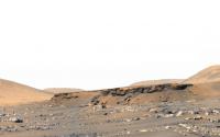
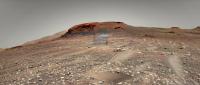
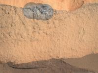
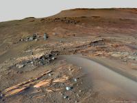
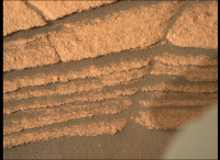
Layered outcrops at the base of Cape Nukshak.
1. Sol 420 Mastcam-Z image mosaic from a distance of about 44 m, with enhanced colors. I see two different layered units here: a bluish-gray unit on top of a orange-brown unit. 2. Sol 420 Mastcam-Z anaglyph 3. Sol 421 Navcam, now very close (about 5 m) 1
|
|||
|
|
|
|||
|
Apr 28 2022, 08:32 PM
Post
#43
|
||
|
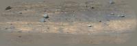
Junior Member Group: Members Posts: 75 Joined: 8-July 15 Member No.: 7566 |
I agree, there's two distinct units here, corresponding to the different colours of the "bacon strip". I wonder what the significance of that colour difference is? This Mastcam zoom-in taken today shows cm or mm-scale layering. Perhaps that represents annual cyclicity. The grain size seems to be too fine to resolve individual grains, certainly it's finer-grained than the aeolian sediment ontop of it. I hope the rover does an abrasion here so we can see how thin the layering is & try and resolve some grains with the hand lens.
|
|
|
|
|
|
|
Apr 28 2022, 09:42 PM
Post
#44
|
||
 Senior Member Group: Members Posts: 2428 Joined: 30-January 13 From: Penang, Malaysia. Member No.: 6853 |
Sol 422 NavCam after a short bump
I have a feeling we could be here for a while
|
|
|
|
|
|
|
Apr 29 2022, 03:25 AM
Post
#45
|
||
|
Solar System Cartographer Group: Members Posts: 10151 Joined: 5-April 05 From: Canada Member No.: 227 |
Sol 422 circular view. As Paul says, just a small move.
Phil
-------------------- ... because the Solar System ain't gonna map itself.
Also to be found posting similar content on https://mastodon.social/@PhilStooke Maps for download (free PD: https://upload.wikimedia.org/wikipedia/comm...Cartography.pdf NOTE: everything created by me which I post on UMSF is considered to be in the public domain (NOT CC, public domain) |
|
|
|
|
|
|

|
Lo-Fi Version | Time is now: 25th April 2024 - 04:15 AM |
|
RULES AND GUIDELINES Please read the Forum Rules and Guidelines before posting. IMAGE COPYRIGHT |
OPINIONS AND MODERATION Opinions expressed on UnmannedSpaceflight.com are those of the individual posters and do not necessarily reflect the opinions of UnmannedSpaceflight.com or The Planetary Society. The all-volunteer UnmannedSpaceflight.com moderation team is wholly independent of The Planetary Society. The Planetary Society has no influence over decisions made by the UnmannedSpaceflight.com moderators. |
SUPPORT THE FORUM Unmannedspaceflight.com is funded by the Planetary Society. Please consider supporting our work and many other projects by donating to the Society or becoming a member. |
|