DSCOVR |

  |
DSCOVR |
 Mar 26 2016, 09:27 PM Mar 26 2016, 09:27 PM
Post
#106
|
||
 Senior Member  Group: Members Posts: 1669 Joined: 5-March 05 From: Boulder, CO Member No.: 184 |
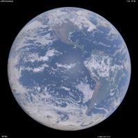
Thanks Explorer1. One thing with the synthetic image (2 posts back) is that the clouds near the limb look too bright. One of the reasons turns out to be that ozone absorption of the light rays interacting with clouds and terrain was left out. So here's an update with this effect mostly included, along with some aerosol adjustments.
(Edited Mar 27 1640UTC) -------------------- Steve [ my home page and planetary maps page ]
|
|
 |
 
|
|
|
Apr 30 2016, 06:46 PM
Post
#107
|
|
|
Senior Member Group: Members Posts: 1669 Joined: 5-March 05 From: Boulder, CO Member No.: 184 |
More details on these synthesized Earth images can be found in my inaugural Planetary Society blog post.
There are a series of comments to this post. I was cutting my two comments a bit short to fit in the character limit. Thus to be more complete I would insert the following paragraph in between these two comments: .......................................... The question about brightness and contrast relates in part to step (3) in my post. One way to check this is to consider that the brightest clouds have a reflectance of about 100%. The cloud-free ocean regions with the Rayleigh scattering (and a slight augmentation from aerosols) should have a reflectance of around 12% in green light (550nm). If the bright white clouds are set to a pixel value of 255, then the green component of the the ocean regions should be 255 * (0.12 ^ 0.45) or 98 counts. The 0.45 power is the gamma correction I'm using to account for the non-linear brightness relationship between pixel count and displayed intensity on a typical computer monitor. .......................................... I might also add that the question of how to set brightness, contrast, and color saturation applies just as much to everyday photography as in spacecraft imagery. I'm following the notion that it's good to have the displayed image be as linearly proportional as possible to the actual scene, with the same color saturation. (Edited May 31, 2016) -------------------- Steve [ my home page and planetary maps page ]
|
|
|
|
|
Jun 28 2016, 08:32 PM
Post
#108
|
|
|
Senior Member Group: Members Posts: 2105 Joined: 13-February 10 From: Ontario Member No.: 5221 |
Space weather instruments are done commissioning, finally: http://spaceflightnow.com/2016/06/27/new-a...ive-next-month/
Is it just me, or does the embedded image of the eclipse looks different from those on the EPIC page, a lot brighter/less muted? Also first I'm hearing of a successor to launch in 2022! |
|
|
|
|
Jul 8 2016, 04:40 PM
Post
#109
|
|
|
Senior Member Group: Members Posts: 1669 Joined: 5-March 05 From: Boulder, CO Member No.: 184 |
I like the URL and where they are going with the imagery:
http://blueturn.earth/ https://vimeo.com/173723357 On another note pertaining to the character of the blueness of the Earth, I can offer the notion that the ground view of the overhead sky with thin scattered clouds (and the sun at a moderately low altitude) is rather similar (with a bit of imagination) to the space view looking straight down at the ocean. If you have a lot of imagination you can get a sense of vertigo looking up such a sky - and think you're really looking down. Thus I'd consider the contrast between the darker blue and brighter white should be less than what we see in the videos above, assuming we want the display to be linearly proportional to the actual brightness. -------------------- Steve [ my home page and planetary maps page ]
|
|
|
|
|
Jul 20 2016, 05:03 PM
Post
#110
|
|
|
Senior Member Group: Members Posts: 2105 Joined: 13-February 10 From: Ontario Member No.: 5221 |
One year highlight video is as good as I hoped: https://www.youtube.com/watch?v=CFrP6QfbC2g
|
|
|
|
|
Jul 29 2016, 05:13 PM
Post
#111
|
|
|
Senior Member Group: Members Posts: 1669 Joined: 5-March 05 From: Boulder, CO Member No.: 184 |
Here is the Blueturn version with a somewhat smoother presentation: https://vimeo.com/175935487
-------------------- Steve [ my home page and planetary maps page ]
|
|
|
|
|
Sep 13 2016, 07:20 AM
Post
#112
|
|
|
Newbie Group: Members Posts: 11 Joined: 29-August 16 From: Israel Member No.: 8032 |
Thanks Steve for pointing at my videos.
A word about the technique: this is a simple interpolation of EPIC images based on orthographic projection on a 3D sphere, and linear blending in the geodesic space. The results are good enough to provide a new earthgazing experience, like in this video of the week around the summer solstice: https://vimeo.com/172956335 The less time between each images, the better the quality. Note that EPIC images are separated by around 1 hour around summer time, and by 2 hours around winter time. But for some exceptional occasions, like the March, 9th eclipse, NASA granted us with only 20 minutes between images, which led to the best interpolation results: https://vimeo.com/170798080 Some work remains to fix quality issues, like the artifacts on the limbs and the lighting correction in interpolated images. Note that the interpolation runs in real-time (30fps) in an interactive app, provided the images are already downloaded from NASA and uploaded into the GPU texture memory. So a lot of the effort is about paging the textures efficiently to provide a smooth video experience. One may find it difficult to see the movement of the clouds, because their speed is very slow comparing to the rotation of the Earth. But you can see them better if you keep looking at the same geographic point, like in this video of a sandstorm in Egypt: https://www.instagram.com/p/BHKDx8RDobB/ |
|
|
|
|
Oct 13 2016, 06:10 PM
Post
#113
|
|
|
Senior Member Group: Members Posts: 1669 Joined: 5-March 05 From: Boulder, CO Member No.: 184 |
Thought I'd mention that I'm attempting to resolve a discrepancy in the geometry contained in the metadata. For a case that I'm simulating, the image at 18:04 UTC on September 20 states that the SEV angle is 9.2 degrees (on the website). If I use the subpoint (centroid) of the spacecraft from the json file (4.3N and 102.6W) though I come up with a solar elevation angle consistent with an SEV angle of about 10.4 degrees. My simulated image also shows a bit more limb shading than the actual image. Judging from my simulated image the sub-point looks OK since the continents line up pretty well. Thus I wonder if the stated time of the image could be off by a few minutes and is actually about 18:08?
-------------------- Steve [ my home page and planetary maps page ]
|
|
|
|
|
Oct 13 2016, 06:49 PM
Post
#114
|
|
|
Senior Member Group: Members Posts: 2105 Joined: 13-February 10 From: Ontario Member No.: 5221 |
Any idea what the bright yellow spot in this image around Ecuador (a much more amateur question!) http://epic.gsfc.nasa.gov/epic-archive/nat...12163939_01.png
Cosmic ray hit, downlink issue, something else? Strange how hurricanes look harmless, even cute, at such a distance... |
|
|
|
|
Oct 13 2016, 09:06 PM
Post
#115
|
|
 Member Group: Members Posts: 705 Joined: 3-December 04 From: Boulder, Colorado, USA Member No.: 117 |
Looks to be in about the right place on the disk to be a specular reflection from a lake, which would be cool.
John |
|
|
|
|
Oct 13 2016, 10:08 PM
Post
#116
|
|
|
Senior Member Group: Members Posts: 3516 Joined: 4-November 05 From: North Wales Member No.: 542 |
There is a place called Lagunas on the Amazon tributary Maranon in about the right place. However my atlas also shows that another tributary the Ucayali has wide reaches not too far away. (Both locations are in Peru.)
|
|
|
|
|
Oct 22 2016, 05:20 PM
Post
#117
|
|||
|
Senior Member Group: Members Posts: 1669 Joined: 5-March 05 From: Boulder, CO Member No.: 184 |
Here's an advance simulated animation (click on MP4 link) of next year's eclipse from the DSCOVR perspective. This is without clouds.
http://stevealbers.net/albers/allsky/4ld_polar.mp4
And while I'm here, this is a simulated vs actual recent DSCOVR view as a blinking animation. Some improvements have been made since my description of this in the TPS blog. The case is from September 20. -------------------- Steve [ my home page and planetary maps page ]
|
||
|
|
|
||
|
Oct 29 2016, 02:28 PM
Post
#118
|
|
 Senior Member Group: Members Posts: 4256 Joined: 17-January 05 Member No.: 152 |
Nice, Steve. You mentioned before the interesting fact that when you are looking at the ocean most of the light is scattered up in
the atmosphere above the water, rather than a reflection of the sky (or diffuse scattered sunlight, ie extended opposition surge) in the water. This makes me wonder what the disk would look like if the atmosphere were gone. So no scattered light in the air or reflection of sky in water. Ie, what is the colour of the water itself, and how dark would it be? Presumably the land would also be quite a bit more contrasty. Is it easy for you to remove the air from a simulation?... |
|
|
|
|
Oct 30 2016, 03:17 PM
Post
#119
|
||
|
Senior Member Group: Members Posts: 1669 Joined: 5-March 05 From: Boulder, CO Member No.: 184 |
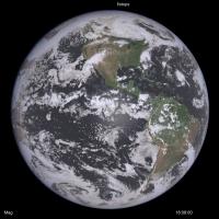
Thanks fredk. The funny thing is that once I inadvertantly ran this without air and the ocean indeed looked darker. This was a goofy accidental run (image below) with Mars atmospheric pressure and Earth aerosols. The display looks somewhat reasonable, though the water looks too gray and thus would need more work. The ocean (outside of sun-glint areas) should be around a factor of 10 darker for the case of few aerosols in the sky and sediment in the water, though it could be a smaller ratio otherwise. The color would also vary depending on sediment content and the like, ranging from blue-green to sometimes more brown.
Note that sun-glint over water is different from the opposition effect that happens over the land. The sun-glint region is controlled by wave action, though I suppose this could be extended a bit depending on forward scattering by atmospheric aerosols then reflecting off of the water, diffused again by wave slopes. -------------------- Steve [ my home page and planetary maps page ]
|
|
|
|
|
|
|
Oct 31 2016, 04:36 PM
Post
#120
|
|
|
Newbie Group: Members Posts: 11 Joined: 29-August 16 From: Israel Member No.: 8032 |
QUOTE (scalbers @ Oct 13 2016, 08:10 PM)  Thought I'd mention that I'm attempting to resolve a discrepancy in the geometry contained in the metadata. For a case that I'm simulating, the image at 18:04 UTC on September 20 states that the SEV angle is 9.2 degrees (on the website). If I use the subpoint (centroid) of the spacecraft from the json file (4.3N and 102.6W) though I come up with a solar elevation angle consistent with an SEV angle of about 10.4 degrees. My simulated image also shows a bit more limb shading than the actual image. Judging from my simulated image the sub-point looks OK since the continents line up pretty well. Thus I wonder if the stated time of the image could be off by a few minutes and is actually about 18:08? Hi Steve, I also have a weird discrepancy when confronting the ephemeris data provided on the EPIC website against the images themselves. See this video I generated from my Blueturn app, of the last July 5th Moon photobombing, when I also represent a virtual Moon model at the location provided in the ephemeris. I just don't understand the difference. I double checked and couldn't find any error in my perspective projection matrix. It looks like either the Moon position is wrong, or the DSCOVR position (all in J2000), or the time stamp itself. Or, maybe this is because my rendering engine is OpenGL-based and is in floating precision. What do you think ? I saw your nice simulation of the future eclipse across the US, so maybe you could also re-simulate the July 5th, 2016 Moon crossing, and tell me if you see the same difference as I do... See the video, or a direct deep link to my WebGL app (the virtual ephemerid-based Moon is right-most) : https://vimeo.com/189285144/6916063e34 http://blueturn.earth/app/EarthPlayer/?dat...0&cameraY=0 (Press 'm' to show the virtual Moon) |
|
|
|
|

|
Lo-Fi Version | Time is now: 20th September 2024 - 12:06 PM |
|
RULES AND GUIDELINES Please read the Forum Rules and Guidelines before posting. IMAGE COPYRIGHT |
OPINIONS AND MODERATION Opinions expressed on UnmannedSpaceflight.com are those of the individual posters and do not necessarily reflect the opinions of UnmannedSpaceflight.com or The Planetary Society. The all-volunteer UnmannedSpaceflight.com moderation team is wholly independent of The Planetary Society. The Planetary Society has no influence over decisions made by the UnmannedSpaceflight.com moderators. |
SUPPORT THE FORUM Unmannedspaceflight.com is funded by the Planetary Society. Please consider supporting our work and many other projects by donating to the Society or becoming a member. |
|