MSL Route Map |

  |
MSL Route Map |
 Jun 12 2019, 08:21 PM Jun 12 2019, 08:21 PM
Post
#1291
|
|
|
Solar System Cartographer  Group: Members Posts: 10150 Joined: 5-April 05 From: Canada Member No.: 227 |
Hi. North is always at the top unless specifically stated otherwise. So the mountain is always off the map towards the bottom right. The maps at JPL show the context better.
https://mars.jpl.nasa.gov/msl/mission/whereistherovernow/ Incidentally, anyone is free to make their own maps here including 'value-added' versions of mine. Phil -------------------- ... because the Solar System ain't gonna map itself.
Also to be found posting similar content on https://mastodon.social/@PhilStooke NOTE: everything created by me which I post on UMSF is considered to be in the public domain (NOT CC, public domain) |
 |
 
|
|
Jun 14 2019, 03:01 AM
Post
#1292
|
||
|
Solar System Cartographer Group: Members Posts: 10150 Joined: 5-April 05 From: Canada Member No.: 227 |
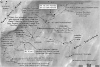
Here is a map update to sol 2434 showing the drive to Waypoint 4. I'm not sure that Waypoint 4 and Marwick Head are the same place but I will correct this if necessary.
I added some recent names. The big blocks of names will shrink later when I can move some to close-up (large-scale) maps. Phil
-------------------- ... because the Solar System ain't gonna map itself.
Also to be found posting similar content on https://mastodon.social/@PhilStooke NOTE: everything created by me which I post on UMSF is considered to be in the public domain (NOT CC, public domain) |
|
|
|
|
|
|
Jun 14 2019, 05:55 AM
Post
#1293
|
|
 Senior Member Group: Members Posts: 1083 Joined: 19-February 05 From: Close to Meudon Observatory in France Member No.: 172 |
QUOTE (Phil Stooke @ Jun 14 2019, 05:01 AM)  Here is a map update to sol 2434 showing the drive to Waypoint 4. I'm not sure that Waypoint 4 and Marwick Head are the same place but I will correct this if necessary. I added some recent names. The big blocks of names will shrink later when I can move some to close-up (large-scale) maps. Phil Thank you so much Phil for your latest map. I was (nearly) lost on Mars : you were there  |
|
|
|
|
Jun 15 2019, 09:12 AM
Post
#1294
|
|
 Member Group: Members Posts: 887 Joined: 15-June 09 From: Lisbon, Portugal Member No.: 4824 |
Update to sol 2436. Per the Mission Updates, Curiosity should by now have reached the Teal ridge, southwest of the 2436 location, but I don't have the path.
Fernando  The_Martian_Way_MSL_Curiosity_Sol_2436_2019JUN15.kmz ( 663.26K )
Number of downloads: 212
The_Martian_Way_MSL_Curiosity_Sol_2436_2019JUN15.kmz ( 663.26K )
Number of downloads: 212 |
|
|
|
|
Jun 16 2019, 03:53 AM
Post
#1295
|
||
|
Solar System Cartographer Group: Members Posts: 10150 Joined: 5-April 05 From: Canada Member No.: 227 |
Here's my update to sol 2436. Looks like I will be needing a new map pretty soon.
Phil
-------------------- ... because the Solar System ain't gonna map itself.
Also to be found posting similar content on https://mastodon.social/@PhilStooke NOTE: everything created by me which I post on UMSF is considered to be in the public domain (NOT CC, public domain) |
|
|
|
|
|
|
Jun 18 2019, 08:44 PM
Post
#1296
|
||
|
Solar System Cartographer Group: Members Posts: 10150 Joined: 5-April 05 From: Canada Member No.: 227 |
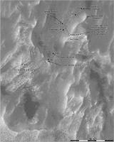
A quick return to the overview map until I get a new close-up base map ready. We got up onto that ridge very nicely.
Phil
-------------------- ... because the Solar System ain't gonna map itself.
Also to be found posting similar content on https://mastodon.social/@PhilStooke NOTE: everything created by me which I post on UMSF is considered to be in the public domain (NOT CC, public domain) |
|
|
|
|
|
|
Jun 22 2019, 01:36 PM
Post
#1297
|
|
|
Member Group: Members Posts: 887 Joined: 15-June 09 From: Lisbon, Portugal Member No.: 4824 |
Update to sol 2444 (location is still that of sol 2439).
Fernando
The_Martian_Way_MSL_Curiosity_Sol_2439_2019JUN22.kmz ( 663.61K )
Number of downloads: 204 |
|
|
|
|
Jun 28 2019, 06:21 PM
Post
#1298
|
||
|
Solar System Cartographer Group: Members Posts: 10150 Joined: 5-April 05 From: Canada Member No.: 227 |
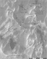
Sol 2449 - making our way through the valley.
Phil
-------------------- ... because the Solar System ain't gonna map itself.
Also to be found posting similar content on https://mastodon.social/@PhilStooke NOTE: everything created by me which I post on UMSF is considered to be in the public domain (NOT CC, public domain) |
|
|
|
|
|
|
Jun 30 2019, 03:22 PM
Post
#1299
|
|
|
Member Group: Members Posts: 887 Joined: 15-June 09 From: Lisbon, Portugal Member No.: 4824 |
This update introduces a feature I've been wanting to implement for some time: a distance grid. I thought it would be easy, but it turned out to be trickier than I anticipated. The real cartographers, I'm sure, won't fail to find that distances (using GE ruler) are only approximate to within 1%. Despite using 15 digit precision in calculations, and the meters per degree value of HiRISE images, I could not achieve exact distances (without cheating!). I don't know what causes it, I hope to be forgiven!
Grids can be cluttering so I implemented both one 1-km-spaced grid, which is good at zoomed out distances, and a 100m grid, best used at zoomed-in distances. Both are labeled on their edges with the distance in km, North/South and East/West, from the origin - Bradbury Landing. When the location, or amount of zooming, does not allow to see an edge, the grid looses a bit of its value. A solution would be to label each intersection of grid lines, but this generates a lot of cluttering. The solution is, thus, to still mark each grid lines' intersection but make the label visible only when placing the cursor over it. On the 100m grid the km lines and the labels have a different color from the other lines and labels. The grids are not visible when initially loading the file but can be enabled from the left side panel: open the twistie named "Distance Grids" and select one (the 100m grid includes the 1km one, so there is no need to have both simultaneously visible). Update to sol 2449, with the latest names from Phil and the distance grids. Enjoy and send in your comments! Fernando
The_Martian_Way_MSL_Curiosity_Sol_2449_2019JUN30.kmz ( 709.28K )
Number of downloads: 209 |
|
|
|
|
Jul 3 2019, 07:34 PM
Post
#1300
|
|
|
Solar System Cartographer Group: Members Posts: 10150 Joined: 5-April 05 From: Canada Member No.: 227 |
One thing to keep in mind with distances is that there may be a difference between the scale of a map in the north-south direction and in the east-west direction. A simple cylindrical (equirectangular) projection where the latitude-longitude grid is plotted as a grid of perfect squares has a uniform scale in the N-S direction, but its scale in the E-W direction varies with latitude because meridians (N-S lines) get closer as you approach the poles. Curiosity is only 5 degrees from the equator, but there will be a small difference between the E-W scale and the N-S scale. I use Quickmap a lot with the Moon, and there you have to be very careful with scales. The scale bar is only accurate in the N-S direction even though it is drawn in the E-W direction. The E-W scale is the scale at the equator times the cosine of latitude.
Google Earth ... you would think I would know how it calculates scale but I'm not sure. It could be checked by measuring the length of 1 degree of latitude and 1 degree of longitude in the mid-latitudes where they should be very different (I don't have GE on the laptop I am on right now to check it). Phil -------------------- ... because the Solar System ain't gonna map itself.
Also to be found posting similar content on https://mastodon.social/@PhilStooke NOTE: everything created by me which I post on UMSF is considered to be in the public domain (NOT CC, public domain) |
|
|
|
|
Jul 3 2019, 07:38 PM
Post
#1301
|
||
|
Solar System Cartographer Group: Members Posts: 10150 Joined: 5-April 05 From: Canada Member No.: 227 |
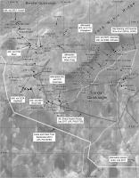
Here's a map update to sol 2454 just in time for the US holiday. Here in Canada we are already in post-holiday mode (we are that much more advanced than our colleagues south of the border). The white squares are places where the arm is used for APXS, MAHLI, sometimes DRT and occasionally the drill. At other points only remote sensing is done (including ChemCam).
Phil
-------------------- ... because the Solar System ain't gonna map itself.
Also to be found posting similar content on https://mastodon.social/@PhilStooke NOTE: everything created by me which I post on UMSF is considered to be in the public domain (NOT CC, public domain) |
|
|
|
|
|
|
Jul 5 2019, 12:48 PM
Post
#1302
|
|
|
Member Group: Members Posts: 887 Joined: 15-June 09 From: Lisbon, Portugal Member No.: 4824 |
QUOTE (Phil Stooke @ Jul 3 2019, 08:34 PM) One thing to keep in mind with distances Thank you Phil for the explanation. You gave me an idea and I want to do some tests, but I'm too busy at the moment.I thought that being so close to the equator the effect would be negligible but it is not. I do have to warp the images when creating GE overlays (such as Curiosity's orbital map) as they are equirectangular projections. CheersFernando |
|
|
|
|
Jul 5 2019, 06:49 PM
Post
#1303
|
|
 Member Group: Members Posts: 684 Joined: 24-July 15 Member No.: 7619 |
QUOTE (Phil Stooke @ Jul 3 2019, 07:34 PM) One thing to keep in mind with distances is that there may be a difference between the scale of a map in the north-south direction and in the east-west direction. (snip) Google Earth ... you would think I would know how it calculates scale but I'm not sure. It could be checked by measuring the length of 1 degree of latitude and 1 degree of longitude in the mid-latitudes where they should be very different (I don't have GE on the laptop I am on right now to check it). Phil Interesting point. Simple question - Is the surface of Mars fractal? Simple answer - YES. Much harder question - What is the fractal dimension of the surface Curiosity has traversed? Well, that's likely a dissertation waiting to be written. Never mistake the map for the world. The measurement of distance depends on the size of the ruler you're using. Example, old-time surveyors measured distances using actual chains, they measured distance along the ground in units of chain links. Fast forward to today, and surveyors use GPS, which measures distance based on line-of-sight. Problem is: if you have a 45% degree slope, orbiter measures 1.0 kilometer, Curiosity rover might measure just over 1.44 kilometers, but you'd get a larger number from the smaller Sojourner rover that climbs every ripple and cobble. So, has anybody tried to calculate the fractal dimension of the Martian surface? Perhaps used changes of the fractal dimension of the Gale Crater surface to help determine when Curiosity has crossed from one sedimentary unit into a different unit? |
|
|
|
|
Jul 5 2019, 08:16 PM
Post
#1304
|
|
|
Solar System Cartographer Group: Members Posts: 10150 Joined: 5-April 05 From: Canada Member No.: 227 |
"if you have a 45% degree slope, orbiter measures 1.0 kilometer"
Not if we are measuring on an orthophoto, taking relief into account. Also, rovers tend to avoid 45 degree slopes. You are right, of course, that relief changes the distance driven and that different rovers might measure different distances based on the sizes of relief features they negotiate. But I don't think this discussion is about the difference between rover-measured distances and map-measured distances. It's about the accuracy of the Google Earth ruler. Nogal mentioned using 15 digit precision. I don't think the registration of images to the Mars control network (including scaling and map projecting) is good enough to even approach that level of precision. Phil -------------------- ... because the Solar System ain't gonna map itself.
Also to be found posting similar content on https://mastodon.social/@PhilStooke NOTE: everything created by me which I post on UMSF is considered to be in the public domain (NOT CC, public domain) |
|
|
|
|
Jul 5 2019, 10:22 PM
Post
#1305
|
|
|
Senior Member Group: Members Posts: 2346 Joined: 7-December 12 Member No.: 6780 |
QUOTE (HSchirmer @ Jul 5 2019, 07:49 PM) What is the fractal dimension of the surface Curiosity has traversed? The fractal dimension is scale-dependent and varying with the location. Moreover, Curiosity's wheels are smoothing topographic features smaller than the radius of the wheels, such that we'll get a pretty well-defined two-dimensional manifold on the scale of Curiosity's wheels. Think of the envelope or hull defined by a sphere of the same radius as the wheels placed at any point of the (fractal) surface. Call smaller topographic features roughness or texture, and separate it from the just-defined smooth 2D hull. The only remaining uncertainty is soft surface material like dust or pebbles potentially displaced by the rover. Formally, this could be described by error bounds like any empirical measurement. We don't run into 2D infinities for the smoothed surface. |
|
|
|
|

|
Lo-Fi Version | Time is now: 23rd April 2024 - 09:10 PM |
|
RULES AND GUIDELINES Please read the Forum Rules and Guidelines before posting. IMAGE COPYRIGHT |
OPINIONS AND MODERATION Opinions expressed on UnmannedSpaceflight.com are those of the individual posters and do not necessarily reflect the opinions of UnmannedSpaceflight.com or The Planetary Society. The all-volunteer UnmannedSpaceflight.com moderation team is wholly independent of The Planetary Society. The Planetary Society has no influence over decisions made by the UnmannedSpaceflight.com moderators. |
SUPPORT THE FORUM Unmannedspaceflight.com is funded by the Planetary Society. Please consider supporting our work and many other projects by donating to the Society or becoming a member. |
|