Printable Version of Topic
Click here to view this topic in its original format
Unmanned Spaceflight.com _ Opportunity _ Distant vistas
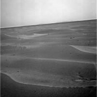
Posted by: fredk Jan 27 2010, 09:31 PM
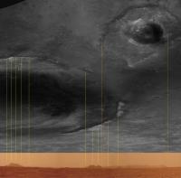
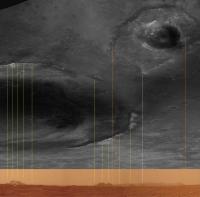
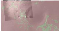
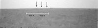
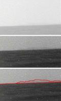
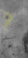
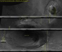
To answer Ustrax's querries from the other thread, I think we can now see more of the south west rim of Endeavour and Iazu. In this image I've lined up the views from 1987 pancam (colour on bottom, from Astro in http://www.unmannedspaceflight.com/index.php?s=&showtopic=5503&view=findpost&p=145455) and 2136 navcam (top, from Ant's navcam mosiac):
|
|
The leftmost (Endeavour north rim) and middle (far rim) features look similar. But it looks like we can see more stuff on the right, which is Endeavour south rim and Iazu. The view we had a few sols ago (2133) of Iazu was still partly obscured by dunes, so it makes sense that we can see more now.
I can't see Bopolu in the navcams, though it could be there and buried in the jpeg noise...
Posted by: Astro0 Jan 27 2010, 09:46 PM
OT - but relevant to the above...
The spot Oppy's at now is a http://www.unmannedspaceflight.com/index.php?showtopic=681&view=findpost&p=153916 compared to the surrounding region, but over the next 5kms or so there's another 45metres of rise before the drop off towards Endeavour. Much better views to come - we'll get the HOAV yet! Are you listening Stu 
But first, there's some fun to be had here at Concepción. 
Posted by: ngunn Jan 28 2010, 10:42 AM

over the next 5kms or so there's another 45metres of rise before the drop off towards Endeavour
Am I misreading the map??? To me it looks more or less level as we continue south, then gently downhill all the way once the predicted path turns east. Even then the gradient will be almost imperceptible and Endeavour and Iazu will remain long skinny horizon features. Of course it will be great to have them constantly in sight at last, but anyone hoping for a sweeping grandstand perspective will I think have to wait much longer - until arrival at Endeavour.
Posted by: Tesheiner Jan 28 2010, 11:44 AM
Looking to http://www.unmannedspaceflight.com/index.php?s=&showtopic=681&view=findpost&p=153839 again, what I see is that we are currently at level "-1370" and the highest point is at "-1325" before dropping down to "-1430" near Mini-Endurance.
Posted by: ngunn Jan 28 2010, 12:44 PM
OK - I think that blurry number is 1395, not 1325. I think the contours are at 5m intervals decreasing monotonically along the route. That was my first impression and on taking another careful look I come to the same conclusion. If we still had to climb 45 metres I don't think we'd be seeing distant views now.
Posted by: Phil Stooke Jan 28 2010, 01:06 PM
Ngunn, I was just about to say the same thing. The labels are not very clear, but the contours don't make sense any other way.
Phil
Posted by: ngunn Jan 28 2010, 02:20 PM
Thanks Phil. I was beginning to question my sanity. If people have been reading it the other way that would explain a lot of earlier posts concerning the view that didn't make any sense to me.
Posted by: Tman Jan 28 2010, 03:24 PM
New pancams are down but no sign of the horizon...or Concepción

Yes, no current pancams in that direction so far, which should roughly be southwestern between 210° to 235° (or -150 to -125 in the PDTInterface) for any signs of Bopulu from the location of Concepción (as measured on your maps).
Posted by: ngunn Jan 28 2010, 03:35 PM
I'm also on the lookout for an isolated hill almost directly south (actually the end of a promontory). My impression is it's not yet visible as we have had recent pancams which I think cover that direction.
Posted by: fredk Jan 28 2010, 04:35 PM
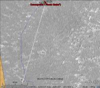
I've done a cross-section plot of the elevations along our actual route between Eagle and Concepción, and from there to Endeavour, to the end of the proposed route originally posted http://www.unmannedspaceflight.com/index.php?s=&showtopic=6404&view=findpost&p=153775 This corrects the blurry number 1325 to 1395. Vertical scale 1 m/px, horizontal scale 24 m/px:
|
|
Lots of approximations here: Distances are in as-the-crow-flies segments, rather than odometer distances. The proposed map in the abstract contains an error, as pointed out above. The horizontal resolution of the MRO elevation data probably means we can't take the precise topography too seriously. Curvature of the surface of Mars ignored.
Still, it gives us an idea of when we might get a HOAV. It looks to me like most of the roughly level plain just west of Endeavour won't be visible until roughly halfway between Concepción and mini Endurance. Curvature works against us, but the
Remember that the vertical scale is exagerated 24 times here! This is still Meridiani, after all. So any "HOAV" we get will likely be dramatic only thanks to the wonder of Phil-o-vision.
Posted by: Phil Stooke Jan 28 2010, 04:44 PM
You're welcome!
Phil
Posted by: climber Jan 28 2010, 04:53 PM
"Curvature works against us".
On flat ground, horizon on Earth is at 8 kms (I guess at human eyes). Do you know the figure for Mars?
Posted by: centsworth_II Jan 28 2010, 05:13 PM
Posted by: fredk Jan 28 2010, 05:53 PM
At the pancam height of 1.55 m, the horizon on Mars is 3.2 km away. Another way to look at is is that in 5 km (most of the way to mini Endurance), the ground will drop by 3.7 m due to curvature. It drops 15 m after 10 km distance.
It looks like we can't resolve those rim peaks on the contour map. But the fact that we could see them since Victoria means they're higher than our current elevation, probably by a fair bit. (Perhaps any more discussion should go to the other thread...)
Posted by: fredk Jan 29 2010, 03:48 AM
|
|
Posted by: fredk Jan 29 2010, 05:22 AM
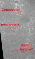
So much to see in these latest navcams. Here's an example of a definite dark feature on the horizon, in front of (part of??) Iazu Crater (lighter band above horizon):

|
I think this is what you were refering to recently, Ustrax? My kingdom for a pancam view...

Posted by: Tman Jan 30 2010, 08:05 AM
There are new pancams now, but only downsampled EDRs and nothing obvious.
Center of the image ~213°: https://qt.exploratorium.edu/mars/opportunity/pancam/2010-01-29/1P318075256EDNAB66P2277L1M1.JPG
~225°: https://qt.exploratorium.edu/mars/opportunity/pancam/2010-01-29/1P318075280EDNAB66P2277L1M1.JPG
~238°: https://qt.exploratorium.edu/mars/opportunity/pancam/2010-01-29/1P318075304EDNAB66P2277L1M1.JPG
Also for that isolated hill southward.
Posted by: ngunn Jan 30 2010, 11:04 AM
Comment and query copied from the other thread:
I note that the nearest Endeavour 'rim' hills actually rise from some way down inside the hole so we won't see their feet till we're almost there. In the Endeavour Crater thread there was a very nice HRSC 3D view of Endeavour which somebody annotated with elevations. I wanted to look at that again but the HRSC links no longer work for me. Can anybody help with that?
Posted by: ustrax Jan 30 2010, 10:58 PM
Exactly Fred! Thanks. Looks like a real feature but I am having some hard time figuring out what it may be comparing with satellite imagery...
This is definitely my kind of thread...bring those pancams and let us find some abysses and stuff!

Posted by: Tesheiner Jan 31 2010, 09:21 AM
http://qt.exploratorium.edu/mars/opportunity/pancam/2010-01-31/1P318162164EFFAB66P2368L7M1.JPG
No doubt at all about which is rear or far rim...
Edit: And, at least for me, this is already a HOAV!
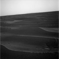
Posted by: Stu Jan 31 2010, 09:30 AM
You want a "Distant Vista"???!!
|
|
Posted by: ustrax Jan 31 2010, 09:32 AM
Punch me more...I love it!!!

Posted by: nprev Jan 31 2010, 09:59 AM
I knew there had to be a significant up-side to chronic insomnia!!!  Beauty & great scientific treasures now in sight, and we few are among the first to ever see such a scene on this world. In the next hours, possibly millions of others will join us.
Posted by: Stu Jan 31 2010, 10:14 AM
... and if you stretch the horizon until it begs for mercy you can see just how hilly it is...
|
|
Posted by: ngunn Jan 31 2010, 10:33 AM
Or (over here) staying in bed long enough.
Thanks for those first mosaics Stu. A great moment - we are truly blessed.
Posted by: ngunn Jan 31 2010, 01:14 PM
Are we still happy with these identifications?
http://www.unmannedspaceflight.com/index.php?act=attach&type=post&id=15887
Is that big dark peak right of centre (of Endeavour) really on the far rim, and if so what's that beyond it?
Posted by: SFJCody Jan 31 2010, 01:20 PM
Takes me back to Spirit's first winter and watching Gusev crater's walls slowly appear as the dust levels dropped.
Amazingly Oppy is only about 16% closer to the big hills on the near side than it was back in Duck Bay! Once they finish heading south and start moving due east the view should improve very quickly. At mini Endurance the distance between Oppy and the big near side hills will be almost exactly half of what it was during autumn 2006.
Posted by: jamescanvin Jan 31 2010, 02:02 PM
http://www.unmannedspaceflight.com/index.php?act=attach&type=post&id=15887
Is that big dark peak right of centre (of Endeavour) really on the far rim, and if so what's that beyond it?
Yes, I'm still happy with that.
I think you might be confused as to which peak is which. (I'm working on the pan and a feature identification plot). 'Cook' the big hill in the middle of the far rim from our POV is the peak on the far left of the images posted, nothing can be seen beyond it. In the middle, is part of the near rim where we are headed with Izau behind it.
James
Posted by: ngunn Jan 31 2010, 02:10 PM
Indeed! Thanks. I can't wait to see the full picture you're working on.
Posted by: Hungry4info Jan 31 2010, 02:30 PM
A frame showing the centre of Concepcion is missing a colour filter or something, leaving it nastily discoloured. I won't claim to speak for him of course, but I would guess that what he posted is the finished project. (any further to the right and it gets pretty terrible)
Posted by: Reckless Jan 31 2010, 02:33 PM
Hi all
It seems all I can say when posting here is "brilliant views"
I remember when Columbia Hills was about the same size as Endeavour is now on the horizon and how keen I (we ) were to get there.
Now I've never been so torn between seeing whats at our feet and everything that's up ahead.
Either way everyday from now is going to be brilliant views.
Thanks again to all for the stuff on this website.
Roy F
Posted by: djellison Jan 31 2010, 02:53 PM
What's kind of cool is that these images of the horizon were taken 16 hrs ago. Seriously - just 16 hrs ago.
Posted by: Stu Jan 31 2010, 03:06 PM
...and I made my pan at 7am, so they were just 8 hours old then?!?! That's fantastic!
(And ESA still hasn't released those 'crescent Mars' images taken by Rosetta years ago. Just saying.)
Posted by: Juramike Jan 31 2010, 03:55 PM
(at least some cameras ESA flies near Mars have a rapid turnaround: (*cough*) http://webservices.esa.int/blog/post/6/958)
Posted by: jamescanvin Jan 31 2010, 04:02 PM
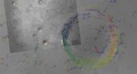
Here are the horizon features plotted alongside another 'inverse-polar' map from this position.
|
I've drawn guide lines from the peaks to appropriate positions on the map in yellow and orange lines highlight the visible extent of Izau (I'm still thinking about identification of peaks)
James
Posted by: Phil Stooke Jan 31 2010, 04:25 PM
The great thing about this is that the view is just going to get better all the time. Apart from the possibility of losing it very briefly behind local drifts in the next one or two km, we'll always have it, and it will get closer and the middle distance will open up more all the time. Exploration at its greatest, as some guy once said.
Phil
Posted by: ngunn Jan 31 2010, 04:26 PM
That's excellent, thanks James! Now we can clearly see that the very nearest rim hills (maybe in fact a slumped portion of the original rim?) are still entirely out of sight below the level surface we are looking across. I thought that might be the case from my attempts to decipher the spot heights on the map, but I'm pretty wary of those now. Seeing is believing.
EDIT: Why the interest in those invisible hiils? I think that's the location of some curious shoreline-like landforms we discussed a while ago and possibly a future destination.
Posted by: fredk Jan 31 2010, 05:17 PM
Fantastic views! Thanks everyone for putting together these mosaics.
Also, it's cool that we're really starting to see features on the features now, at least on the Endeavour rim. I've made a very tentative ID of a crater on the far rim of Endeavour (white circles).
As others have said, the view will get better and better. But on top of improved sight lines, as we head into winter the transparency should improve as well, so we should see more features on these features too.
Edit: I guess I was so excited I forgot to add my pic! Here it is:
|
Posted by: ngunn Jan 31 2010, 05:18 PM
From the 'vistas' point of view the proposed route is perfect. The next short trek SW and S should open up the distant horizon in those directions also before we turn E.
Posted by: NW71 Jan 31 2010, 07:33 PM
Like many previous posts I am just in awe of both the views we are beginning to experience and the expertise of those UMSF members who take the time and trouble to allow us to see these vistas in such a quick, easy and beautiful manner. A big thank you to you all.
I am trying to keep my excitement down to bearable levels (I have already learnt how tiring the emotional rollercoaster highs and lows associated with these two rovers can be!) so i'll simply ask these two questions;
1 - Are the current power levels on Opportunity any cause for concern re reaching Endeavour? (I just have this nightmare of us running out of juice 5 metres from the rim!)
2 - From the photos above it appears that whilst Endeavour is the larger crater and is our target, i think it would be fair to say it looks as though Lazu has an amazing rim. Would there be anything to be gained from trying to get there as well? (I do appreciate it is a long way away but is there anything to suggest it is significantly different from endeavour?)
Finally, I agree with Teshiner, we are definitely in HOAV area! However, I think that bar might be raised in the upcoming months... 
Neil
Posted by: centsworth_II Jan 31 2010, 08:02 PM
While Spirit has had a much rougher trek, Opportunity has been the long distance runner. Here is an inset showing the distance covered by Spirit from Bonneville crater to the Columbia Hills. I estimated the scale based on 2.5 km from Bonneville to the Hills compared with a little over 4.5 km from Victoria to Concepcion.
|
Posted by: centsworth_II Jan 31 2010, 08:06 PM
2 - ...Lazu has an amazing rim. Would there be anything to be gained from trying to get there as well?
1. Power should be no problem, barring another killer dust storm. The biggest problem in my opinion would be mechanical or electrical failures because of age. (Hopefully the rover is now too smart to get stuck in the sand.)
2. Ask again in two years.
Posted by: fredk Jan 31 2010, 08:18 PM
Neil, Squyres was asked about Oppy's power levels at the recent briefing and he said they weren't a concern.
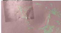
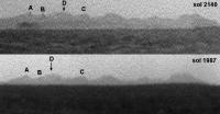
Here's a comparison between the view at sol 1987 (from Astro's mosaic) with the 2140 view (from James' mosaic). Both at 3x vertical stretch. Stunning improvement indeed for Endeavour west rim/Iazu. And significant perspective change - note white line connecting the west rim peaks. Changes within Iazu as well due to near/far rim perspective change, as I remarked earlier when I posted my long baseline anaglyph.
|
|
Posted by: Reckless Jan 31 2010, 08:26 PM
Hi Centsworth_II
I did realize that Oppy is further from Endeavour than Spirit was at Bonneville and thank you for the comparison map all maps are always welcome especially maps with helpful inserts.
Roy F
Posted by: MoreInput Jan 31 2010, 09:03 PM
Cool. Spirit needed only 68 Sols from Bonneville to the Hills (Sol 86 to 154). I estimate the route to endeavour from conception as 4,5 times the route from Bonneville to the Hills (11.25 km? a little short I think) , that means we only need 306 sols to get there :-) But that's of course a minimum guess, maybe we see some interesting stuff on the road ...
Posted by: Tesheiner Jan 31 2010, 10:58 PM
Below the minimum, I would say.
Check the route from e.g. VC up to here and that would give you a better km/month figure.
Posted by: djellison Jan 31 2010, 11:09 PM
Time and again we've played the X metres in Y sols means Z progress game.
It never works
Ever.
Posted by: nprev Jan 31 2010, 11:14 PM
The old saying "You can have it done fast, or you can have it done right" seems applicable here. 
Posted by: eoincampbell Feb 1 2010, 05:52 AM
Feels like the road to Endurance again, which is cool
Posted by: Astro0 Feb 1 2010, 12:34 PM
Stretchy horizon comparison - animation.
|
|
Posted by: ustrax Feb 1 2010, 02:06 PM
Now you've done it...let me have it! let me have it!!!
Posted by: Ant103 Feb 1 2010, 03:10 PM
OMG !! This is amazing Astro0 !! We really have the feeling of a progression now.
Posted by: Oersted Feb 1 2010, 05:30 PM
Oh, yes, that is a great animated gif Astro0!
Posted by: MoreInput Feb 1 2010, 06:38 PM
Cool animation. I starred the whole day long at it, and now I think I glaciers at the Endeavour rim ... ok I starred to much.
But I hope we will get soon a third picture to this animation.
Posted by: walfy Feb 1 2010, 08:18 PM
Wow! That's the first time it looks like a crater, with the foreground and background rim-mountains clearly visible in the same shot.
Posted by: Tesheiner Feb 1 2010, 08:41 PM
Hear! Hear!
Posted by: Tesheiner Feb 1 2010, 08:58 PM
Two things. First of all, just say to everyone that AJS Rayl monthly report on the rovers is already http://www.planetary.org/news/2010/0131_Mars_Exploration_Rovers_Update_Robots.html.
Second, an extract from the named report:
Posted by: pgrindrod Feb 3 2010, 10:00 AM
I've been meaning to post this for a while now, and the recent chat has spurred me on.
I've had a go at predicting what Opportunity can possibly see, both now and further along the predicted route. I took the HRSC topo for the area, overlaid a CTX image, plonked down a marker for (roughly) where I thought Oppy was at the time (about a week ago now), and then let ArcMap figure out what's visible for something 1.8 m off the ground at that point. I then tried again for a different point along the predicted path.
So here's the base map for the area. The green dot is my poor attempt at a location.
|
This is what might be visible at the moment (green is visible, red, er, isn't)
|
And this is what might be visible in the future (from the red dot)
|
This method is very sensitive to both the underlying DEM and the exact location you view from. I can get very different results by moving the marker just a tiny distance. So take it with a pinch of salt, and then add a bucket or so extra for good measure. It'd obviously be loads better if I could stick a HiRISE DEM underneath, as this method worked pretty well for the Pathfinder DEM.
I'm actually hoping that the view heading down the gentle slope will be a lot better than this predicts.
Pete
Posted by: djellison Feb 3 2010, 10:42 AM
Pete - chuck that Pathfinder demo of Viewshed in here as well ( I never got around to using it) - it demonstrates the power of the technique.
What Pete has shown ( for those who haven't figured it out ) is that certainly for the next several KM - we're not going to have a sudden OMFG HOAV moment - it will be a gradual progression as we've seen with Astro0's recent flicking GIF.
Posted by: Tesheiner Feb 3 2010, 01:53 PM
My kingdom for a HiRISE DEM!
Posted by: pgrindrod Feb 3 2010, 02:04 PM
Yes boss! I'll stick it over in the HiRISE DEM thread.
Pete
Posted by: ngunn Feb 3 2010, 02:40 PM
There are just great. Any chance you could extend the area S and SW to check out the potential visibility of Bopulu and 'south hill' from a little south of our present position?
Posted by: ElkGroveDan Feb 3 2010, 02:53 PM
Did we all notice that the SW flank of Victoria should still be visible? ( with deference to the pinch of salt and all that)
Posted by: ElkGroveDan Feb 3 2010, 02:57 PM
If we were really greedy we would ask them to animate the sequence down the drive path so we'd see green features growing and shrinking in the view from above with an in-set image showing a red dot moving down the drive path. But that would take a lot of time and all we have to offer is boundless admiration and praise.
Posted by: fredk Feb 3 2010, 06:50 PM
This is really cool, Pete. I've got a couple of questions/comments. First, does this take into account the curvature of the surface?
Your results definitely look sensible along the inside of the far rim of Endeavour, presumably since the slope is quite large there. But in both plots, there are areas right adjacent to the observation point that aren't green. Why is that? I can see that the blotchiness of the green areas on the flatter areas makes sense, since the slopes there are extremely small. But it should still be green close to the observation point.
I see what you mean by the green areas changing quite a bit when you move the observation point around - again, since the terrain is so flat. I wonder if you could do a series of these plots, each time moving the obs. point around a bit (say within a 10 metre or even 100 metre region), and then take the union of all the green areas. That may eliminate the high frequency noise.
Posted by: pgrindrod Feb 3 2010, 07:40 PM
Yeah I'm troubled by the lack of visibility around the marker point too. My gut feeling is that this is all coming down to the underlying HRSC DEM, which is 75 m/px. This is probably too coarse to do a viewshed at the scale that we're interested in. But I've got to admit that this is the first real time that I've played around with this method so I'm still learning the ins and outs. Now if someone had a CTX DEM of round here...
So I'm going to have a bit of a play around and see how things change as the marker moves around. I've got a feeling that I might be 'overinterpreting the data' as they say (ie making it up!). But the idea of moving around and averaging is interesting, and if I come up with anything then I'll put it up. I might even try a little bit of MOLA as well, see if that improves things, as that's what Tim Parker's LPSC contour map used I think.
Pete
Posted by: Phil Stooke Feb 5 2010, 02:57 AM
Here's an extreme vertical stretch of the hills with a bit of noise reduction from adding frames where possible.
Phil
|
|
Posted by: ngunn Feb 6 2010, 09:31 AM
Something dark on the skyline in this view, though likely not at extreme distance. Is there another small crater in that direction?
http://qt.exploratorium.edu/mars/opportunity/pancam/2010-02-06/1P318164806EFFAB66P2368L7M1.JPG
Posted by: Tesheiner Feb 6 2010, 12:37 PM
Good catch, ngunn!
The heading is consistent with the next crater on the planned route. Here's it on Google Earth.
|
Posted by: Stu Feb 6 2010, 01:04 PM
Wow, we've only just got here and we can already see where we're going next!
|
Posted by: Stu Feb 6 2010, 01:21 PM
Concepcion and the Next Crater, seen at same scale, with the IAS viewer...
|
Posted by: ustrax Feb 6 2010, 04:03 PM
Can't resist...stop me please...

I hereby name you...http://en.wikipedia.org/wiki/Double_Dare_(comics) Aliki & Margot...
Posted by: Nirgal Feb 6 2010, 04:22 PM
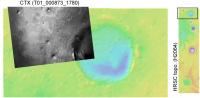
As long as there is no HiRISE DEM yet ... here is a quick try at creating a single-image-DEM from the CTX image T01_000873_1780_XI_02S005W.
(with the whole DEM consisting of about 10 million polygons which is currently about the limit that my software's core math solvers can handle. So the next project I'm working on is to port and compile my sources into a true 64-bit application such that it can make use of the full 12 GB main memory under Vista 64 (I know, I know I should use a Mac, really -> so maybe in the near future it will be able to generate DEMs with 50-100 million polygons.
some oblique views of the area between Victoria and Endeavour:
|
|
|
And the last image is how it might look like from the ground. However, I did not select a special viewing direction ... just played around with the camera position and rotation until it looked good ... ah yes, and the vertical height is somewhat exaggerated too
|
|

Posted by: Tman Feb 6 2010, 04:40 PM
Just at that twin crater we might get a better view to the south(west), i.e a sign of Bopulu crater and the hills eastward of its "promontory".
Oh my, very nice...good stuff, Nirgal!
Posted by: fredk Feb 6 2010, 06:10 PM
Early in this thread I suggested based on the navcams that this feature to the south was the hill far to the south. I agree it looks much too close to be that hill, which is farther than Iazu. But I'm not sure about your identification, Tesheiner. I'll call the close pair of craters you suggested Twin Craters (I guess they're not identical twins!). Measuring the angles each component (A and B ) would subtend at Conception, I find the Twins should look this big:
|
In other words, much bigger than the dark feature on the horizon. But looking closely, there are some dark features (black arrows) that could perhaps be one or both of Twin Craters somewhat closer than the horizon. In L2, these features look bright, which might be exposed bedrock on the rims?
Is there another feature somewhat farther than Twin Craters that the dark feature on the horizon could be?
Posted by: ngunn Feb 6 2010, 07:10 PM
I've been pondering these features, the farther and the nearer, for the last few hours but without having your handle on the subtended sizes. I believed Tesheiner (as one does ) but then couldn't find anything on Stu's Hirise crop that looked like the nearer features. Then again like Tman I thought the downward slope would be starting about where the twin craters are, so wouldn't have expected the ground to rise again immediately beyond. I can't be much use here but I'll stay closely tuned to learn how it pans out.
Posted by: Tesheiner Feb 6 2010, 07:25 PM
We will certainly have to keep an eye on those features once we leave this area.
Fredk is right. Althought the horizon feature is at the right heading, it's too small to be the twin craters; those ones, combined, cover about 3.5º viewed from the current position, while the black feature has only 0.4º.
Unfortunately, the HiRISE picture I'm using doesn't cover that area.
Posted by: Phil Stooke Feb 6 2010, 08:02 PM
Here's a crater in about the right place.
Phil
|
Posted by: ngunn Feb 6 2010, 08:10 PM
That looks highly plausible Phil. How far away is that? Is it on our projected route?
Posted by: Phil Stooke Feb 6 2010, 08:18 PM
It is about where we start to turn to the east after this long trek south and west (about 1400 m south of Concepcion).
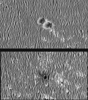
Meanwhile, here is another look at Iazu, a comparison of two sols (cut from a post higher up in this thread). I have labelled four hills, and the way hill D gets displaced relative to the other three suggests it must be on the far rim of Iazu.
Phil
|
Posted by: nprev Feb 7 2010, 05:36 AM
Stu's latest pic (which is a wow!) made me realize something that is stunningly obvious, but bears reflection: All of the geology @ Meridiani is completely buried. It take an impact to bring anything at all up above the sand. This is strikingly different from the other locales on Mars we've been able to see at this scale.
Why?
Posted by: Shaka Feb 7 2010, 08:42 PM
The soft, sulfate sandstone surrounding us at the surface is swiftly and steadily sanded smooth in the short term.
The relatively resistant, robust rocks representing the rest retain the resplendent relief remaining from the remote realm of real rheology and resurfacing.
Really
Posted by: nprev Feb 7 2010, 08:53 PM
Oh, great. Now I gotta come up with a sentence featuring words that start with "Q"??!
Quiescent quiteus, queries quintessential (quixotically?)
I quit!
[EDIT: Quorrected!]
Posted by: djellison Feb 7 2010, 10:51 PM
Quite.
Posted by: NW71 Feb 7 2010, 11:05 PM
please...
Posted by: nprev Feb 8 2010, 01:05 AM
Damned if I didn't misspell "quintessential" to boot (Corrected...I hope!)! Argh. Gonna get the letter Q kicked out of the English language for good; I'll let you all know when it's done.
Posted by: Astro0 Feb 8 2010, 01:17 AM
Please be kwik!
Posted by: ngunn Feb 8 2010, 10:23 AM
Now we are sicks?
http://images.google.com/imgres?imgurl=http://images.easyart.com/i/prints/rw/lg/7/1/Mini-Posters-Winnie-the-pooh---Eeyore-71119.jpg&imgrefurl=http://www.easyart.com/art-prints/Mini-Posters/Winnie-the-pooh---Eeyore-71119.html&usg=__x6GRtxIlWB1NUQBu6xluL2S2GSA=&h=400&w=320&sz=18&hl=en&start=46&um=1&itbs=1&tbnid=5HQZ8J4kvgbcpM:&tbnh=124&tbnw=99&prev=/images%3Fq%3Dwinnie%2Bthe%2Bpooh%26ndsp%3D20%26hl%3Den%26safe%3Dactive%26rls%3Dcom.microsoft:en-US%26sa%3DN%26start%3D40%26um%3D1
Posted by: Phil Stooke Feb 8 2010, 12:01 PM
"Gonna get the letter Q kicked out of the English language for good"
Finally, a use for those defective keyboards from Dilbert.
Phil
Posted by: ngunn Feb 8 2010, 10:59 PM
Referring to the crater that appears on the horizon beyond 'twin craters' -
I'm still not entirely making sense of this. Using the 800m diameter of Victoria for scale I reckon we turn east less than 1400 metres south of Concepcion. Also, 1400 metres south of Concepcion would place that horizon feature below the next (downward) contour on the map. I'm aware of the limitations of the map. So I still don't know if we're going to visit that crater or not, and I'm now additionally uncertain about where the opening up of the view to the S and SW can be expected. Can anybody shed light?
Posted by: fredk Feb 8 2010, 11:25 PM
Ngunn, using the proposed route we've seen from the abstract, I agree that we'd turn east before reaching the "crater beyond twin craters". But nothing stands out for that crater (it doesn't look especially fresh, eg), and I'm sure we'll encounter more similar sized ones on our trek. Of course we have to keep in mind that that's only a proposed route - we're not commited to it. Also the resolution of the proposed map isn't great.
In terms of the view, according to the contour map, the best views will be between the south and east. The rise around "crater beyond twin craters" is towards the SSW, so it shouldn't block our views towards the south to east. I don't know what kind of view we'll get to the SW (eg Bopolu), since I haven't seen a topo map in that direction.
Posted by: fredk Feb 8 2010, 11:45 PM
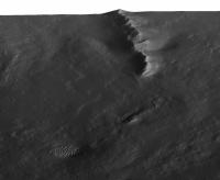
I agree D is on the far rim, and in http://www.unmannedspaceflight.com/index.php?s=&showtopic=6404&view=findpost&p=154033 I also claimed that the bits on the right are far rim. Here's a cross-eyed version of the long baseline stereo view for those red-green challanged out there:
|
|
Posted by: Phil Stooke Feb 9 2010, 04:02 AM
Right, I must have missed that! Very good. That far rim topography is the most distant we can see so far, I assume.
Phil
Posted by: ngunn Feb 12 2010, 02:52 PM
What's that on the right?
http://qt.exploratorium.edu/mars/opportunity/pancam/2010-02-12/1P318165061EFFAB66P2368L7M1.JPG
Posted by: nprev Feb 12 2010, 03:42 PM
Could you be more specific? Nothing jumps out at me.
Posted by: centsworth_II Feb 12 2010, 03:54 PM
|
Posted by: ngunn Feb 12 2010, 03:58 PM
There appears to be a hill on the horizon extending in from the right margin for about 10 percent of the image width. It's visible in 2 of the 3 filters.
EDIT: You got it centsworth.
Looks like I'll just miss the answer - I'm off for a week's holiday now.
Posted by: vikingmars Feb 12 2010, 04:05 PM
Thanks ngunn. Feature noticed also... Enjoy the enhancement
|
Posted by: Phil Stooke Feb 12 2010, 04:33 PM
Comparing this with the circular pan from the other thread, this lies in the right direction to be Bopolu crater.
Phil
Posted by: fredk Feb 12 2010, 09:04 PM
Here's my attempt at pulling Bopolu out of the haze and jpeg noise. Average of L5 and L7, contrast and 3x vertical stretches:
|
Bopolu in its entirety would subtend around 18 degrees for Oppy, while this bit's only about 2 degrees wide. So presumably we're seeing just one high part of the rim now.
Posted by: Phil Stooke Feb 12 2010, 11:48 PM
I guess that's now the most distant bit of terrain we can see.
Phil
Posted by: ElkGroveDan Feb 13 2010, 12:16 AM
...unless we spot a planet or one of the moons in the sky.
Posted by: fredk Feb 13 2010, 01:44 AM
I was curious how the distance to Bopolu compares with the distance from Spirit to Gusev's rim, which is roughly 70 km if I'm right. I make the near rim of Bopolu to be about 58 km from Oppy. The far rim of Bopolu would probably be a bit farther than the Gusev rim from Spirit. So since we could easily see the Gusev rim when skies weren't too dusty, it's not surprizing that we can see out to Bopolu.
Posted by: fredk Feb 14 2010, 04:41 PM
The new pancams from 2153 show more of Bopolu. Also the visibility is a bit better than on our first glimpse - I guess the dust has settled a bit. I've averaged the L7s and L5s, and pieced the frames together (the central strip is the average of all four overlapping frames):
|
|
Actual scale above, 3x vertical stretch below. This is still not the entire 18 degree extent of Bopolu...
Posted by: Phil Stooke Feb 14 2010, 07:19 PM
Very nice, Fred! I hope it stays in view for a while, though it might become less visible when we are in the lower region east of here. Still, around the time we begin to descend we may get better views than this. Now we just need a really good atmospheric clearing! I was just looking back at the early views of Gusev's rim from the Columbia Hills - amazing views at times.
Phil
Posted by: scalbers Feb 14 2010, 08:03 PM
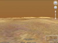
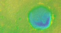
I see on Google Mars that Bopolu rim rises about 1000 feet above the local terrain, and the crater is about 5000' deep. Google Mars can reproduce the view along the horizon seen from Opportunity. Bopolu is the smaller double bump in the center (left of a larger bump).
|
Here's another view from much closer.
|
Posted by: Beauford Feb 16 2010, 08:00 PM
What's the tasty morsel in the "upper right hand corner" at http://qt.exploratorium.edu/mars/opportunity/pancam/2010-02-16/1P319509701EFFABCXP2373L7M1.JPG?!
Posted by: Tesheiner Feb 16 2010, 08:20 PM
The answer is just a few post before yours.
Posted by: fredk Feb 16 2010, 09:41 PM
That morsel is a bit of Iazu - compare it with the Iazu images earlier in this thread.
Posted by: Tesheiner Feb 16 2010, 09:59 PM
Ooops! Fredk is right.
I thought that image was pointing SW towards Bopolu but it's actually to the SE.
Posted by: ngunn Feb 22 2010, 10:42 PM
There's a hill (maybe two) on the horizon to the left here. Is it one we've seen already?
http://qt.exploratorium.edu/mars/opportunity/pancam/2010-02-22/1P318250611EFFAB66P2369L7M1.JPG
Posted by: fredk Feb 23 2010, 01:21 AM
That's Bopolu Crater. From these new images, I don't see any more bits of it compared with our last views, so this will be our best view for the time being.
Posted by: tim53 Feb 23 2010, 01:48 AM
Phil
Sorry for the confusion about this, folks! The files got compressed so brutally when converting to a PDF format small enough to send, that even I can't read the numbers. Attached is the original figure. The "-1370" that was referred to is labeling an isolated line (right under the number). Sadly, Arcmap doesn't make such purdy contours!
The HiRISE wide baseline stereo pair over this region verifies the general aspects of the topography in the MOLA data, but of course is higher in spatial frequency. We are right on the NW edge of a small rise that's probably only a meter or so high and about 200 or so across. Once we finish with Concepcion and head south, we should start to see to the southeast better!
-Tim.
|
Posted by: Michael Zeiler Feb 23 2010, 04:49 AM
With respect to "Sadly, Arcmap doesn't make such purdy contours!", there are some techniques to improve contour output with ArcMap. This blog post has some tips:
http://blogs.esri.com/Dev/blogs/geoprocessing/archive/2009/09/02/Lidar-Solutions-In-ArcGIS_5F00_part7_3A00_-Minimizing-noise-from-lidar-for-contouring-and-slope-analysis.aspx
If you are using a terrain dataset (a multi-resolution TIN), it is generally recommended to convert the next to lowest pyramid level to a raster and then contour against that raster. It's a balancing act between technical accuracy and aesthetically pleasing contours. If you are using a TIN, same concept: convert the TIN to a raster and select a surface interpolation method depending on the character of the data. Then contour the raster. For "purdy contours", we nearly always make contours from rasters (DEMs), not TINs/terrain datasets.
If you direct me to that elevation data set, I could take a look at it and see what I could do with that data.
And for labeling contours, check out the Maplex Label Engine (go to the data frame properties > General tab > Label engine listbox). The laddering option works well for many situations.
Have you looked into making visibility maps from this data? That would be of interest to this forum.
regards, Michael Zeiler, ESRI
Posted by: Tesheiner Feb 23 2010, 09:10 AM
We are all looking forward that view.
Slightly OT but does the project has already a name for that "twin crater" 650m SSW of Concepción?
I know some people who would love to put their hands on that data too. See http://www.unmannedspaceflight.com/index.php?showtopic=5073and http://www.unmannedspaceflight.com/index.php?showtopic=6044.
Posted by: ustrax Feb 23 2010, 01:35 PM
Slightly OT but does the project has already a name for that "twin crater" 650m SSW of Concepción?
http://www.unmannedspaceflight.com/index.php?s=&showtopic=6438&view=findpost&p=155156
but more accordingly with the islands theme:
http://en.wikipedia.org/wiki/Twin_Island
Posted by: tim53 Feb 23 2010, 04:24 PM
http://blogs.esri.com/Dev/blogs/geoprocessing/archive/2009/09/02/Lidar-Solutions-In-ArcGIS_5F00_part7_3A00_-Minimizing-noise-from-lidar-for-contouring-and-slope-analysis.aspx
If you are using a terrain dataset (a multi-resolution TIN), it is generally recommended to convert the next to lowest pyramid level to a raster and then contour against that raster. It's a balancing act between technical accuracy and aesthetically pleasing contours. If you are using a TIN, same concept: convert the TIN to a raster and select a surface interpolation method depending on the character of the data. Then contour the raster. For "purdy contours", we nearly always make contours from rasters (DEMs), not TINs/terrain datasets.
If you direct me to that elevation data set, I could take a look at it and see what I could do with that data.
And for labeling contours, check out the Maplex Label Engine (go to the data frame properties > General tab > Label engine listbox). The laddering option works well for many situations.
Have you looked into making visibility maps from this data? That would be of interest to this forum.
regards, Michael Zeiler, ESRI
Hi Michael:
I will have to verify this when I get in to work in an hour or so, but I either used the gridded global data product from the Planetary Data System (will have to look up the actual link at work as well, but people here probably know what I'm referring to) - most likely - or I contoured the individual data points using the PDS' Orbital data explorer to create a shapefile of shot points within a lat/lon range. This latter option only became readily available about a year ago, so it's possible I didn't use it in this instance.
Thanks for the Arcmap suggestions. I've been slowly familiarizing myself with it's capabilities since I had to 'give up' on Canvas X when ACD Systems abandoned support for the Mac (and since it can't handle files over a GB in size).
-Tim.
Posted by: tim53 Feb 23 2010, 04:25 PM
Slightly OT but does the project has already a name for that "twin crater" 650m SSW of Concepción?
I know some people who would love to put their hands on that data too. See http://www.unmannedspaceflight.com/index.php?showtopic=5073and http://www.unmannedspaceflight.com/index.php?showtopic=6044.
We'll probably try to swing buy this crater on our way to Endeavour. We usually don't name the craters until we're close to them or know we might visit them.
-Tim.
Posted by: Michael Zeiler Feb 23 2010, 08:49 PM
-Tim.
Tim, I know it's a bummer to switch software. ArcMap has a rich set of capabilities, but it's a learning curve to master it all.
Contouring is a tricky proposition and the best technique depends on the nature of the data and striking a balance between technical accuracy and making pleasing contour curves. Label placement is another challenge.
Also, surface analysis can be done both with a DEM (digital elevation model, a raster with elevation values) or a TIN (triangulated irregular network). (A terrain dataset is a multi-resolution TIN optimized for huge point sets such as lidar point clouds). The people who do surface analysis work with both data structures and convert from one to another, depending on the desired map product or analysis they are trying to perform.
An aspect-slope map might be another good way to display the nature of this terrain. See http://blogs.esri.com/Support/blogs/mappingcenter/archive/2008/05/22/aspect-slope-map.aspx
This technique displays aspect (direction of slope) using a color hues and slope using saturation. This blog post outlines the individual steps, but I know that we've released a geoprocessing model that largely automates this whole process.
Another topic on interest on this forum is identifying distant features on the horizon. A viewshed map can easily help identify potential features visible from a point and this is relatively easy to make once you have a DEM. See http://webhelp.esri.com/arcgisdesktop/9.3/index.cfm?TopicName=Performing_a_viewshed_analysis
If you need technical assistance with ArcMap, you can contact me. If I don't know the answer, I know the experts who do.
- Michael
Posted by: pgrindrod Feb 24 2010, 09:06 AM
Well I had a pop at the viewshed before, but was kind of limited by the DEM I was using (75 m/px HRSC), and the fact that I hadn't lifted the view off the ground.
So here's the viewshed from Opportunity, from a few weeks back now, from 1.8 m above the ground. It doesn't look all that different to the ones I posted before to be honest.

|
And a possible view somewhere along the predicted path:

|
These don't take the curvature of the planet into consideration, as there's no easy way (to my knowledge) of changing the radius to that of Mars rather than the Earth (apart from fooling Arc with the original projection etc.). And switching on the curvature just for the hell of it does seem to make quite a difference in terms of what's visible on the horizon; that effect could be even greater for Mars then.
So there are my usual warnings not to take my distant vistas too seriously! I'm having a look at the aspect-slope map now - will post back if it works ok.
Pete
Posted by: pgrindrod Feb 24 2010, 09:32 AM
Well that didn't take too long
Here's the aspect-slope map of the same area as before (Victoria is left of centre at the top), made in exactly the same way as suggested in Micael's link.
|
It looks good, but I'm not sure that it helps too much in figuring out what we can see in the distance (due to resolution of DEM etc...).
Hmmm, I wonder what else I can use Arc for now...
Pete
Posted by: tim53 Feb 24 2010, 03:55 PM
Pete
Using the HRSC DEM is an excellent idea at low latitude sites, since the MOLA ground tracks can be a couple of kilometers apart at the equator. I've experimented with this data in other places, but not at Opportunity. I'll have to take a look at it, as the 75m spatial resolution is considerably better than the MOLA coverage there.
-Tim.
Posted by: pgrindrod Feb 24 2010, 05:33 PM
Yep, the HRSC DEM is good, but I'd still like a CTX one
Just to show what the underlying DEM looks like for all these viewsheds, here's a couple of coloured hillshades with contours (one with labels, one without). I haven't done anything fancy to make the contours, just whatever the default settings are in Arc. The green dot is Opportunity a few weeks ago.

|
|
Pete
Posted by: SteveM Feb 24 2010, 09:09 PM
I recall reading many years ago that if you tweak the refraction parameter appropriately, you can fool Arc about the radius of the planet. Sorry I can't give you a reference on that.
Steve M
After checking Google I found details http://webhelp.esri.com/arcgisdesktop/9.2/index.cfm?TopicName=How%20Viewshed%20works
Posted by: tim53 Feb 24 2010, 10:23 PM
Back in the olden days, before we had MOLA topography, and back when I was trying to anticipate what we might be able to see after Pathfinder landed, I looked at the visibility of distant objects at the Viking landing sites and realized that local topography is more important than the size of the planet, and submitted this abstract to LPSC:
-Tim.

Posted by: Stu Feb 25 2010, 09:06 PM
Very nice view of the distant hills today...
http://qt.exploratorium.edu/mars/opportunity/pancam/2010-02-25/1P319941552ESFABCXP2378L6M2.JPG
Posted by: vikingmars Feb 25 2010, 09:17 PM
-Tim.
Tim, I remember this paper very well and we had then a discussion with Cheick Diarra about the implications of seeing distant features and reprensenting them on maps for large public audience for the sake of our future Mars Outreach...
Posted by: Phil Stooke Feb 26 2010, 01:06 AM
Stu pointed to this image - here's a bit of a vertical stretch of it.
Phil
|
|
Posted by: SteveM Feb 26 2010, 01:23 AM
Phil
I have a question for the image processing whiz kids here. I've filtered the region above the horizon line with the standard 2d median in photoshop, which does a good job of removing the compression noise but smears the mountain peaks and valleys. Since the brightness of the horizon profile increases (roughly) monotonically with increasing elevation, it seems that a median filter applied along segments of single vertical columns centered on the pixel of interest would remove much of the compression noise without distorting the image significantly. Is anyone able to implement such a filter and apply it to our horizon profiles?
Steve M
Posted by: Phil Stooke Feb 26 2010, 03:08 PM
I don't know about that... but here I've subtracted a high-pass-filtered version of the image above from the original. The HPF version was chosen to retain the small-scale mottling but suppress the rest. When it's subtracted this is what remains. A bit fuzzy but a lot cleaner.
Phil
|
|
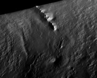
Posted by: fredk Feb 26 2010, 04:09 PM
Continuing to squeeze every bit of signal out of that L6 view of Iazu as possible, we have two versions of that image, M1 and M2. They are stretched quite differently, so the jpeg artifacts appear to be uncorrelated between them. So we can reduce the artifacts by averaging the two. Here's the result (after stretching the M1 version to match the M2), with 3x vertical stretch:
|
|
You can see that the bit on the right that was missing in M1 is noisier than the rest. A bit of smoothing happened during the rotation.
Posted by: Phil Stooke Feb 26 2010, 06:49 PM
Very nice - I like those spiky hills at the right end.
Phil
Posted by: SteveM Feb 26 2010, 10:06 PM
Phil and Fred,
I didn't make myself clear, so here's a picture (worth a thousand words of clarification). This is a median filtered version of the original image, it nicely cleans up the compression artifacts but (as you can see) makes the peaks and valleys less jagged.
|
|
I think that if someone could implement a median that operated on vertical line segments (portions of a single column of the image) it would not round off the peaks and valleys and we could see them more clearly.
Steve M
Posted by: Astro0 Feb 27 2010, 01:01 PM
This is certainly a view worth a little more tweaking.
Interesting to see the methods everyone is using.
|
|
Posted by: Phil Stooke Feb 27 2010, 01:22 PM
I understand exactly what you mean, Steve, I just don't know how to do it!
Phil
Posted by: Geert Feb 28 2010, 01:23 AM
Mathematically it's possible to calculate the distance from some 'mountain' top by measuring the angle it is protruding above the horizon (even it the foot of the hill is still invisible below the horizon), or vice versa you can calculate the height of the object if you know the exact distance to it.
Theoretically it seems to me it would be possible to do this same calculation on Mars, we can calculate the angle by measuring the number of pixels a hill is protruding above the horizon (total camera viewing angle is known as well as total pixel height of the image). It would surely be only a very rough result, but it might be fun to see how it works out and compares to orbital measurements.
Two problems are that you need to take into account the refraction of light (well known on earth, but on Mars?) and you need to be certain that the horizon you see is indeed the horizon and not some landmark or hill, so the flatter the landscape the better it works.
I don't know whether anyone has ever tried to do this?
Posted by: fredk Feb 28 2010, 03:56 AM
Yeah, I did this a while ago for the east rim of Endeavour http://www.unmannedspaceflight.com/index.php?s=&showtopic=5503&view=findpost&p=141528
We can now see quite a bit more, and I estimate we can now see close to 200 metres of vertical extent of the east rim.
Refraction would make the hills look shorter than they really are, so 200 metres would be a lower limit. But I doubt refraction matters too much here since the atmosphere is so thin.
We can't see all of the rim yet, so there's got to be more height to the rim hills than we can see yet. So again 200 metres is a lower limit, but probably not by much.
Posted by: JohnVV Feb 28 2010, 04:52 AM
http://www.imagebam.com/image/bd853c69940005
for noise like this i have been using GRAYCstoration from the bash shell .
There is a new Gimp plugin called GMIC
the above pic"1P319941552ESFABCXP2378L6M2.JPG"
[attachment=20860:crop.png]
a height 2x using Gmic
[attachment=20861:crop.h2x.png]
http://www.imagebam.com/image/be771369940435 http://www.imagebam.com/image/896f2969940436 3x height http://www.imagebam.com/image/0f6b0069940437
variations
http://www.imagebam.com/image/3278eb69940869 http://www.imagebam.com/image/abcb1e69940870
all the above are using Gimp plugin
Posted by: Explorer1 Feb 28 2010, 04:58 AM
Is the rim taller or shorter then the Columbia hills? That would be a useful practical comparison. I've tried searching for their height but can't seem to find it anywhere, except McCool hill at around 130 metres or so.
Who knows, Opportunity might do some climbing before EOM. That would be an undisputed "heckuva view", right?
Posted by: ngunn Feb 28 2010, 09:21 AM
Explorer, your post has prompted me to do some digging back in relation to possible future hills and vistas. I've remarked on most of this previously but here I've collected some relevant images from earlier posts.
First the contour map from tim53, post 113 above:
http://www.unmannedspaceflight.com/index.php?act=attach&type=post&id=20806
This shows the downslope increasing quite sharply near the end point of the yellow line. The view forward should become increasingly spectacular over the last km. or so of that route. It also shows that the nearest group of hills to the south rise from a base that is already well down the slope into Endeavour Crater. We do not even see the tops of those hills yet, so for the moment let's call them the 'invisible hills'.
Next pgrindrod's excellent visibility map from post 120 above:
http://www.unmannedspaceflight.com/index.php?act=attach&type=post&id=20817
The invisible hills are aboult half way up that image and indeed show no green shading.
Now to go a bit further back here is a crop of the Endeavour HiRise image posted by SFJ Cody in post 105 of the Endeavour thread:
http://www.unmannedspaceflight.com/index.php?act=attach&type=post&id=16180
I think this shows the northernmost detached part of the invisible hills (rotated 180 degrees?), surrounded by a shoreline-like feature. (**speculation alert - Endeavour Lake???**).
Finally, a vertically exaggerated view which nevertheless gives a good impression of the vertical extent of the topography within Endeavour, all of which should be visible from the viewpoint in question. This is from Marswiggle's post 121 in the Endeavour thread:
http://www.unmannedspaceflight.com/index.php?act=attach&type=post&id=17360
If someone with the google Mars facility could post a virtual panorama from the end of the yellow projected route that would be just wonderful.
EDIT: One more handy link to add - a zoomable CTX courtesy of Stu, post 117 in 'Endeavour drive, drivability analysis' thread:
http://global-data.mars.asu.edu/ctx/img/P01_001414_1780_XI_02S005W
Posted by: fredk Feb 28 2010, 03:56 PM
Pete, could you post a higher-resolution version of the plot with contour labels? I was trying to see if your plot agreed with my estimate above of the height of the east rim hill of a bit over 200 metres, but the resolution is not quite enough...
Posted by: pgrindrod Feb 28 2010, 04:55 PM
hi fredk. i'm afraid this is all i've got with me in houston - will it do? it's the biggest i could squeeze in under 1 mb, but if you pm me i could probably email you a bigger version.

|
if you need anything else like countours changing, or specific point measurements or profiles, then i'm afraid it'll have to wait until i'm back at ucl.
pete
Posted by: Explorer1 Feb 28 2010, 10:16 PM
If the rim is 200 meters, then it's way taller than McCool, the tallest Columbia Hill. Quite a view!
But from what a PM told me there's no good geological reason for Oppy to climb the rim, is there?
But I'd be happy to settle for just reaching their base one day.
Posted by: ngunn Feb 28 2010, 11:21 PM
Explorer1 I'm trying to help here. On the side we are approaching from (west) Endeavour doesn't have a rim. There is nothing to climb. We should get the view just by descending gradually across the plain to the point where the ground slopes away a bit more steeply into the crater.
Posted by: scalbers Mar 1 2010, 12:23 AM
Here's a rough idea looking SE from near Endeavour with Google Mars:

|
Posted by: Explorer1 Mar 1 2010, 01:08 AM
Oh, that clears it up, thanks!
Posted by: fredk Mar 1 2010, 01:23 AM
That's great, thanks Pete. I can now read the elevation of east rim hill, and it looks like roughly 200 metres above the surrounding plains. So we are seeing essentially all of that peak above plain level now.
But east rim peak is roughly 700 metres above the lowest point inside Endeavour, which happens to be adjacent to east peak. That's some serious topography.
Posted by: ngunn Mar 2 2010, 10:46 PM
Just in case anyone is following this thread but not Nirgal's 3D from 2D magic don't miss these previews of the 'invisible hills':
http://www.unmannedspaceflight.com/index.php?showtopic=6413&view=findpost&p=156307
Posted by: Stu Mar 4 2010, 06:52 AM
Nice...
|
|
|
|
Posted by: fredk Mar 4 2010, 09:00 PM
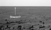
The new pancam series includes the N to NE horizon, where Victoria would be if it's still visible. Since we'll presumably start dropping soon, this may be our last good chance to see it. I think the Beacon/Cape St. Mary is barely visible. I've pointed to it on this image - the azimuth looks pretty much right, but there's no guarantee we're not just seeing big dunes here:
|
Check out http://www.unmannedspaceflight.com/index.php?s=&showtopic=6204&view=findpost&p=148327 for a comparable previous view of the Beacon, from sol 2039.
Doing a Phil-o-vision on the new image, we can perhaps see the outline of Victoria. The angular width is about right:
|
|
Posted by: jamescanvin Mar 4 2010, 10:48 PM
OK I've been poring over these horizon images along with my retrojected orbital HRSC image and other bit and pieces from this thread + Google Mars for ages! I am now pretty confident that I have everything identified correctly (or pretty close).
|
James
Posted by: ngunn Mar 4 2010, 10:58 PM
That is a fantastic piece of work James. I did wonder about that part of the skyline beyond Endeavour too. Are we sure it's not part of the Iazu apron?
PS - I wish they'd pan around to the north rim again.
Posted by: djellison Mar 4 2010, 11:04 PM
Would projected CTX images be of use? The PDS released images are uncalibrated and unprojected, but I've got the process sorted in ISIS3, it's not too bad actualy, so if someone gives me the ob-ID, I'll get them map projected.
Posted by: Stu Mar 4 2010, 11:12 PM
That's a brilliant piece of detective work, James. Really brings the whole scene to life.
I wish we had some names - even just working names - for those distant hills and peaks. Maps are so much better with names. Soon tho, I'm sure.
Posted by: jamescanvin Mar 4 2010, 11:35 PM
ngunn,
I don't think the distant horizon can be part of Iazu, it just doesn't stretch that far east. Also, it looks more 'hazy' than the rest of Iazu. Looking at Google Mars it does suggest that we should have an horizon about 10km (ish) beyond Endeavour in that direction.
Doug,
I'd love to have a CTX base map of the area. Not sure how much time I'll have to do any further analysis, but here are some ID's of CTX images that would cover all of Endeavour and Iazu.
P13_006135_1789_XN_01S005W
P15_006847_1770_XN_03S005W
P17_007849_1793_XN_00S005W
Stu,
Rui has named everything around here hasn't he?
James
Posted by: djellison Mar 4 2010, 11:38 PM
Anything Rui has not named, will just call it Ultreya A through Z.
I've got those three CTX images downloading (140-250 meg each - and I generate about 4 times that in the CTX processing pipeline) - I'll squirt them out tomorrow...and SEE how hard it is to mosaic them within ISIS...but I wont spend to much time on that. I'll zip up PNGs or something and send you a link.
Posted by: djellison Mar 5 2010, 12:13 AM
For the P13 ob - ISIS is happy. For the other two, I don't think the kernels have hit the ISIS Rsync server, so I can't project them reliably. I'm going to fudge it assuming nadir-pointing.
Posted by: Tesheiner Mar 5 2010, 06:50 AM
Had you tried searching for their correlative HiRISE's? The pointing would be the same.
Posted by: djellison Mar 5 2010, 07:37 AM
It would error the same way- tge kernels are external to the images, and HiRISE data would simply be looking for the same missing data. The kernels are quite laggy getting into ISIS, way behind the imaging data.
Posted by: jamescanvin Mar 5 2010, 08:17 AM
There may be others that cover the same area, I just grabbed a few ID's off of Google Mars.
It would be good to have as accurate a map as possible to help with alignment of horizon features - fudging it may just confuse me more than I already am!
Posted by: djellison Mar 5 2010, 08:23 AM
Well - anything starting 13 or less is great. I'm not sure they started imaging that way much before it was decided to head there thigh. CRX is 30km wide though - so we might be in luck.
Posted by: Tesheiner Mar 5 2010, 09:04 AM
I'm used to search at this site: http://global-data.mars.asu.edu/.
Start with the "webmap" option, zoom to the area of interest, click on the arrow button (select) and then on the map again.
Posted by: Stu Mar 5 2010, 09:55 AM
WARNING! If you've never used Mars Global Data before, be very careful. It's dangerous. VERY dangerous. It's the Mars website equivalent of a packet of Pringles or a box of Maltesers - once you start, you can't stop. Oh yes, you go on there thinking "I can handle it, I'll just have a quick look", then you start clicking... and clicking... You tell yourself "Just one more"... click... "Ok, just ONE more..." click... and before you know it it's dark outside, the rest of the family are in bed, and there's a cold cup of coffee on the desk beside you...
Posted by: ustrax Mar 5 2010, 10:04 AM
Fantastic work James! I can't believe we have come this far, able to see the hills REALLY unfolding before our eyes...
About the names...we all know http://www.unmannedspaceflight.com/index.php?act=attach&type=post&id=18432? Ah!
Posted by: Stu Mar 5 2010, 10:27 AM
I wasn't discounting your names Rui I meant more 'official' names so we can all follow the journey. Your names are great. You're going to need some more tho, looks like lots of smaller peaks on top of the main hills. Better start researching if any of those sailors had pet dogs or cats...
Posted by: tim53 Mar 5 2010, 10:58 PM
I don't think the distant horizon can be part of Iazu, it just doesn't stretch that far east. Also, it looks more 'hazy' than the rest of Iazu. Looking at Google Mars it does suggest that we should have an horizon about 10km (ish) beyond Endeavour in that direction.
Doug,
I'd love to have a CTX base map of the area. Not sure how much time I'll have to do any further analysis, but here are some ID's of CTX images that would cover all of Endeavour and Iazu.
P13_006135_1789_XN_01S005W
P15_006847_1770_XN_03S005W
P17_007849_1793_XN_00S005W
Stu,
Rui has named everything around here hasn't he?
James
My personal favorite is P21_009141_1780_XI_02S005W_080708, because it was taken with a very small emission angle (and is thus nearly perfectly Nadir), and so high-frequency topography is least distorted in this image, compared to others.
I'm working on a new CTX/HiRISE mosaic for my route mapping for the project, and put this CTX mosaic together some time ago (so it doesn't include much of Iazu). At least it's not so big I can't paste it here (I *think* >> edited to add, oops! It's an order of magnitude too big!). Scaled up to match the overlying HiRISE images in something like Photoshop, it's about 100GB, though! Fortunately, Arcmap and Global Mapper don't resample to match the scales.
-Tim.
Posted by: Tesheiner Mar 6 2010, 09:12 AM
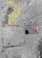
I've been using most of these images on my route map version.
Here's the top left part of it --the so called "context map"-- where I have labelled all background pictures.
|
There are three CTX images (from left to right: P01_001414_1780_XI_02S005W, P17_007849_1793_XN_00S005W, and P13_006135_1789_XN_01S005W) and basically two HiRISE images (PSP_009141_1780_RED and PSP_010341_1775_RED) plus a tiny bit of HiRISE ESP_011765_1780_RED to cover the area we're right now.
Edit: Now I'm wondering that I should change the old "001414" image. It's the only one with an off-nadir pointing so it doesn't match so well with the other ones.
Posted by: Stu Mar 6 2010, 12:14 PM
Just making some new slides for my next talk (thanks for the help, James!), thought some of you might find this useful in making sense of Oppy's horizon view...
|
Close up of those particular hills here...
http://twitpic.com/16xi9m/full
Crying out for the full 3D view treatment, I'd say...
Posted by: tim53 Mar 10 2010, 03:04 AM
Bopolu on the horizon!
Amazing, since it's so far away. (about 65 km to center of the crater).
-Tim.
Posted by: Tesheiner Mar 10 2010, 06:55 AM
Where, where! Oh, that's unfair Tim.
You have privileged access to the raw images. We here will have to wait for the next exploratorium update in about two hours.
Posted by: Stu Mar 10 2010, 06:59 AM
Tim, that's just cruel.
Posted by: Tesheiner Mar 10 2010, 08:47 AM
Here it is!
http://qt.exploratorium.edu/mars/opportunity/pancam/2010-03-10/1P321453662EFFABWUP2389R1M1.JPG
(Click to enlarge)
Ahh! I got my daily fix.
Posted by: JohnVV Mar 10 2010, 10:29 AM
nice but that is one noisy image
quick cleaning
[attachment=21002:clean1.png]
Posted by: walfy Mar 10 2010, 10:55 AM
I kinda like the noisy image better. Seems the cleaned image has lost a lot of detail.
Posted by: ustrax Mar 10 2010, 11:36 AM
Amazing! So many things to name so few words...guess I'll have to invent a new lexicon...
Posted by: djellison Mar 10 2010, 04:41 PM
FWIW - Calibrated images almost always have less noise than the raw JPG's. That 'detail' you're talking about is most likely noise that shouldn't even be there.
Posted by: Phil Stooke Mar 10 2010, 06:14 PM
Here's a different version... worst noise removed and a tweak to the brightness.
Phil
|
Posted by: Phil Stooke Mar 10 2010, 06:19 PM
And a stretched version of the topography. Is there something very faint near the right edge?
Phil
|
|
Posted by: JohnVV Mar 10 2010, 10:11 PM
there is always a trade off between noise and detail
gmic dose a good job and so dose a fft
and some of the noise is the jpg artifacts
after fft showing the jpg
[attachment=21011:Screenshot_2.png]
My personal pet peev is the jpg artifacts .the jpg format should be illegal
Posted by: ngunn Mar 10 2010, 10:45 PM
Where's fredk?
I think we already see that (and some tiny bits in between) in his post 104.
Posted by: fredk Mar 11 2010, 01:54 AM
I'm over here!
Here's my take on the latest view of Bopolu. L6 and R1 registered and averaged to reduce jpeg artifacts. Linear contrast stretch and 3x vertical stretch (bottom). No smoothing/noise reduction apart from what happened during rotation.
|
|
Much better than our views on previous sols! I wonder if the improvement is just a more fortuitous auto stretching of the jpl jpegs, or if the sky is clearing too.
Posted by: Bill Harris Mar 11 2010, 02:44 AM
I think it's a case of increasing atmospheric transparency-- remember the crisp views of Endeavour/Iazu just a few days ago at Sol 2170. And it's only going to get better...
--Bill
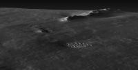
Posted by: jamescanvin Mar 11 2010, 10:46 PM
I've taken the image fredk made and tried to do some feature mapping on a reprojected HRSC image of Bopolu. I think this should be pretty close, the Google Mars 3D matches pretty well with what we see (also included) which gives me some confidence I'm in the right ballpark.
|
James
Posted by: djellison Mar 11 2010, 10:47 PM
If it's down to atmospheric opacity, it's almost certain to get worse and better and worse and better..
Posted by: fredk Mar 12 2010, 04:14 AM
Nice job, James! That GM view is really convincing.
Posted by: Bill Harris Mar 12 2010, 05:04 AM
Posted by: SteveM Mar 14 2010, 01:20 PM
Steve M
Posted by: Phil Stooke Mar 14 2010, 01:51 PM
What about the view of the hill?
Phil
Posted by: fredk Mar 14 2010, 04:46 PM
The views should improve in the coming months because we're heading into winter, when the transparency's best. I doubt the tiny changes in elevation we'll do will make much difference.
Posted by: Tesheiner Mar 14 2010, 07:13 PM
We should also take into account that the route will turn due east and head directly towards Endeavour once we go past the twin craters. After that point, the view should also start to become better in terms of resolution.
Posted by: ngunn Mar 14 2010, 08:58 PM
Slight downgrade and smaller ripples should also help.
Posted by: ngunn Mar 15 2010, 11:44 AM
I was delighted to find a nice 4-frame horizon pan among today's images and I've assembled a paper copy. Bopulu is on the right and each of the leftmost two frames contains one prominant dark horizon feature. The one in the second frame looks like the feature Phil identified here:
http://www.unmannedspaceflight.com/index.php?act=attach&type=post&id=20656.
From our current position I reckon the twin craters should be about 7 degrees to the left of that, but the two dark horizon features are about 15 degrees apart. In short, I'm not really sure of the identification of either of them, or where (or if) the twin craters actually appear in this view.
Help!!
Posted by: Tman Mar 15 2010, 04:26 PM
I get these values from the position on sol 2181. The feature at 181° should be a part of the twin craters.
But it seems to me it's just the left rim of the left crater (from the viewpoint of Oppy on sol 2181) and because of the twin craters cover about 5 degrees in this image your 7 degrees could roughly match nevertheless...
|

|
Posted by: ngunn Mar 15 2010, 05:40 PM
OK, but that's a little unexpected since from fredk's earlier post below it would seem that the twins' most prominent feature is the mound smack in between them and the rest of the leftmost crater doesn't show at all:
http://www.unmannedspaceflight.com/index.php?act=attach&type=post&id=20655
Of course if the feature that Phil identified (tentatively) is actually something rather farther away then a 15 degree angle between it and the twins midpoint could make sense. But Phil's identification was quite convincing . . .
Posted by: fredk Mar 15 2010, 07:37 PM
I'm not sure what features are twin craters or if we can even see them yet, but the features I ID'd in the image you posted above can't be the twins. From our current viewpoint, they should've parallax shifted to the left compared to the distant feature much more then they have. So it seems all of these features are quite a bit farther than the twins. I guess it's not too surprizing the twins are hard to see, if they don't have much in the way of raised rims.
Edit - I agree with Tman that the feature at azimuth 181 degrees is about right for Twins.
Posted by: ngunn Mar 15 2010, 08:10 PM
OK so we have two horizon features. Tim's '181' and the one about 15 degrees to the right of it as seen from here. Probably both are further away than the twins, which may not break the horizon although they should lie close to the 181 azimuth of the leftmost horizon feature. Would that be a fair assessment? Phil's earlier identification of the rightmost of the pair probably depended on your earlier ID of the twins, fredk, so it seems to me that both of the horizon features now still await secure identification on the map. Here are links to the two images in which they appear, a little right of centre in both cases:
http://qt.exploratorium.edu/mars/opportunity/pancam/2010-03-15/1P321808039EFFAC00P2391L6M1.JPG
http://qt.exploratorium.edu/mars/opportunity/pancam/2010-03-15/1P321808285EFFAC00P2391L6M1.JPG
Posted by: Stu Mar 15 2010, 08:57 PM
|
No Dougal, those hills are far, far away...
Wow, just noticed today marks the 6th anniversary of me joining the forum... Thanks to everyone who makes it such a great place to hang out and, of course, thanks to Doug for starting it in the first place.
Posted by: Geert Mar 15 2010, 10:32 PM
Given the fact that the rover positions are quite accurately known, if the same features turn up in images taken at different sols (different positions), wouldn't it be possible to triangulate the features on the map?
The distance between the L/R pancam/navcam is way too short for accurate measurements over such distances, but if you have images/measurements taken at different positions, you might have a baseline which is long enough to get a good enough fix on the positions of these features.
I don't know whether there is accurate azimuth bearing information for the images (relative to true north, iso relative to rover) or if you can derive it from the relative camera bearing and the rover bearing itself, but otherwise, once you have clearly identified one feature you should be able to get the bearing of every other feature by counting pixels (given that the camera field of view is known).
Posted by: fredk Mar 15 2010, 11:00 PM
Yeah, that's more or less what I did when I concluded the original ID's were wrong. We should've seen much more parallax shift between the features. But that was a relative argument. I guess what you're saying is if we have absolute azimuths for each image, we can work out distances for features, if they're not too much farther away than our baseline, and if errors in the absolute azimuths don't dominate.
Posted by: Geert Mar 16 2010, 03:28 AM
Yep, if you have absolute azimuths for each feature, you can work out the exact position (lat/lon) of each feature. Accuracy will depend on the length of your baseline (distance between positions/images) and the accuracy of your azimuth. The more different bearings (different images/azimuths) you get, the more accurate your positionplot also.
But even if you do not have absolute azimuths you could probably work out locations if you have two known and one unknown feature, just by measuring the number of pixels (along the horizon) between the features. Given a known baseline (distance between the two positions where the images were taken) and known positions, you can work out the true position of object number 3 (compared to known objects 1 and 2) if you measure the angle (count pixels) between objects 1-2, 2-3, and 1-3 in both images. I would have to work through some of the books again, but it should be possible.
Posted by: ngunn Mar 16 2010, 10:10 AM
I've noticed something, in fact two things, in today's images. They're so faint that they may not be real at all but they're in both the L and R views. Looking back I now think I can see them in yesterday's images too. They are a couple of bumps on the horizon about 2 degrees and 3.5 degrees to the left of the dark horizon feature here:
http://qt.exploratorium.edu/mars/opportunity/pancam/2010-03-16/1P321987812EFFACFNP2392L6M1.JPG
I'll try to post annotated images but with my primitive IT skills that won't be quick.
Edit: The left of the two is directly above a nearer dark dune.
Posted by: ngunn Mar 16 2010, 10:25 AM
Attached (hopefully)

Posted by: ngunn Mar 16 2010, 10:51 AM
And from yesterday:
Posted by: ngunn Mar 16 2010, 11:53 AM
Possible ID?
Oops arrows missing, trying again.
Posted by: jamescanvin Mar 16 2010, 12:58 PM
I don't have a change to check the ID but a couple of weeks ago I was actually looking for features in the pancams to match the ID you point to, thinking that there was a chance they might visible. I couldn't spot anything then, but hopefully the clearing atmosphere has changed that.
The feature is actually part of the rim of the gigantic Miyamoto Crater, whose name will be familiar to may here as one of the rejected MSL landing sites. Although that particular feature is actually much closer (just outside the landing ellipse in fact) of another rejected MSL site 'South Meridiani'
Posted by: ngunn Mar 16 2010, 01:46 PM
Cue a much nicer context image (though I notice the colouring is a bit mis-registered with the topography):
http://mars8.jpl.nasa.gov/msl/news/images/20080918a/Miyamoto_ellipse2.jpg
BTW you don't say if you see real features where my arrows point in the pancams. I'm still waiting for confirmation that they're really hills and not something I should see a doctor about.
Posted by: fredk Mar 16 2010, 02:57 PM
I agree there are two very faint features on the horizon to the left of the most prominent dark feature. They are visible in both 2181 and 2183 images. I don't have the software to view your identification files, but my guess is that these features might be the "south hill" features we've been looking for for some time, at about the same distance as Bopolu. Nice catch!
Posted by: Bill Harris Mar 16 2010, 03:45 PM
I'm not worrying about the distant-distant features for right now. We'll be at Twin Craters in a week or so, a bit closer to where the slope breaks and with one less intervening feature. Meanwhile, I'm going to be looking at the sand and rock under our wheels and on the lookout for changes afoot.
--Bill
Posted by: ngunn Mar 16 2010, 04:11 PM
Its only a word document with arrows on it.
Anyhow at first I thought it could be those outlying hills at Bopolu distance, but I thought these blips were too close together and a bit too far to the right for that, so I plumped for a couple of higher peaks farther away on the Miyamoto rim. Highly speculative at this stage but I'm sure James will nail it for us (and maybe the nearer features at the same time).
Posted by: Bill Harris Mar 16 2010, 05:28 PM
OK, I got to fiddling around with those Pancams from today-- 1P321987621EFFACFNP2392R1M1 and the next one. Cropped, stretched, pasted and enhanced, the panorama ain't pretty, but it does show what ngunn and Fred note. The nearby dark horizon feature, Twin Craters, on a slight rise on the left which drops off to the right, showing a more distant horizon behind the rise. On this horizon is another crater on the right, with a pair of faint hills to the left of it.
Rather like Russian nested-dolls, no?
--Bill
|
|
Posted by: ngunn Mar 16 2010, 06:44 PM
Very nice Bill! That shows the situation really well.
I think I've found a terrestrial analog :
http://www.nat-park.com/mule-ears-big-bend-national-park/
Posted by: Bill Harris Mar 16 2010, 07:20 PM
I know the Big Bend region well-- I used to take a holiday in the FtDavis/Marfa/Alpine area many years ago. 10,000 foot altitude, all volcanic rhyolite (sorta a continental basalt).
A personal terrestrial analog during that trip just occurred to me. The drive across Texas is long and for the most part traverses flat, flat terrain. Many miles from the mountains of west Texas-Big Bend you begin seeing the peaks just start to poke up over the horizon and grow over the better part a day, much like the distant craters are doing at Meridiani.
It's been 20 years, but let me see if I can locate old photgraphs and see how far away we spotted the mountains. I'm thinking 20-30 miles, but you know how fish stories are...
--Bill
Posted by: AndyG Mar 16 2010, 07:46 PM
I think I can believe that. The day I saw the images of the Bopolu peaks, I was driving at just around sunset to my local supermarket. From the crest of a hill (in Airdrie, North Lanarkshire, Scotland) I saw mountains on the western horizon, back-lit by the sky, which turned out to be Goat Fell and its chums on Arran. Google Earth says "80km" - fifty miles - line of sight to those 2000 foot hills.
Andy
Posted by: helvick Mar 16 2010, 08:31 PM
50 miles certainly isn't outrageous when visibility is good and the target is high. I lived on the south coast of Ireland in West Waterford and could easily see 100-200m headlands to the east about 30 miles away from about 10 meters above sealevel when visibility was reasonably OK. Hook head lighthouse was somewhere between 50-60 miles to the east and it's top (at about 25m at a guess) was below the horizon or close enough that I could never make it out, even with a telescope on a perfectly clear day. It was almost always obvious on clear nights though, strobing just over the horizon.
I also recall a holiday in Switzerland in the 80's when the Alps were an obvious hulking presence to the south when viewed from the foothills of the Jura mountains about 40-50miles to the North. No peaking up over the horizon there - as I recall I had to look up at the peaks even at that distance but memory may be confusing me.
Posted by: fredk Mar 16 2010, 09:16 PM
At risk of stretching this thread title completely off the planet Mars, I can't help chiming in. I've seen the Olympic mountains in Washington state from Vancouver on a very clear day, at about 140 km (85 miles) distance. And Mt Rainier, Washington is sometimes visible from Victoria, BC at a whopping 210 km (130 miles). I'm sure people can top these sightings, though - Hawaii or similar islands from the sea? The Andes or other coastal ranges from the ocean?
Posted by: Stu Mar 16 2010, 09:29 PM
From my backyard I can see the Andromeda Galaxy... 2 million light years away...
I win
Posted by: Explorer1 Mar 16 2010, 11:35 PM
I can confirm what fredk says about seeing Washington from Vancouver. Mt. Baker is the most visible one (should be quite a show when it blows!), but with a little height the others beyond are visible too.
And yes, one can see clear across the Strait of Georgia to Vancouver Island, on a clear day.
But we should really be getting back to Mars now.....
Posted by: Bill Harris Mar 17 2010, 01:19 AM
This isn't too bad a digression-- we're relating the Distant Vistas we see on Mars to something we can relate to.
I found some notes on Texas road map which suggest that I started seeing the mountains in the Ft Davis (Ft Stockton, actually) area somwhere to the west of Midland, Texas, which would make the distance 85-90 miles.
Back to Mars: although the air is thin, the dust is very very fine and can be easily held in suspension. The dustiest part of an atmosphere is that part close to the ground. The line of sight to Endeavour and Bopolu is close to the ground for a few kilometers until the elevation starts to drop off. It is amazing how far we can see here.
--Bill
Posted by: jamescanvin Mar 17 2010, 08:15 AM
Back on Mars, I made a start at matching the features ngunn spotted. On sol 2181 the drive direction mosaic includes both the new feature and Boplou so aligning it with my reprojected HRSC images is fairly easy. I didn't get a chance to finish making a graphic but I got far enough to think the ID is indeed the high part of the Miyamoto rim that ngunn pointed to.
Posted by: Tman Mar 17 2010, 10:39 AM
Here is a (1/4 res.) crop from http://hirise.lpl.arizona.edu/ESP_012820_1780
(1,6Mb) http://www.greuti.ch/oppy/ESP_012820_1780_concep_twin_others.jpg
Posted by: vikingmars Mar 17 2010, 12:08 PM
From the City of Dijon in Burgundy, by a very clear day, you can see Mont-Blanc peak : that's a similar distance (220km).
"Avenue du Mont-Blanc"is named in Dijon after it...
Posted by: Phil Stooke Mar 17 2010, 01:14 PM
"Mt Rainier, Washington is sometimes visible from Victoria, BC at a whopping 210 km (130 miles)."
Yes, I've seen that myself, on an unusually clear day! But the rainier the day, the less you can see.
Phil
Posted by: ngunn Mar 17 2010, 03:31 PM
Ironically I'd just about persuaded myself Fred must be right. I think I'll just wait till a consensus is reached.
One thing I have done is make a few measurements which convince me that we are gradually opening up the angle between the 'Mule Ears' and the thing to the right (which needs a name so I'm going to call it 'Rockaway' unless someone has a better suggestion). Whatever they turn out to be they provide a convenient 'fixed point' for comparisons (animations?) of the changing scene as we move south. A rough distance for 'Rockaway' should already be derivable.
Another suggestion, since I don't know how to do it myself, is that since our view of the 'Mule Ears' is more or less unchanging it should be possible to get a clearer picture of them by stacking all the images we get while we're on this heading.
Posted by: Stu Mar 17 2010, 03:41 PM
Opening up nicely on the horizon now...
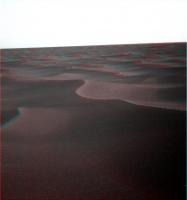
|
Posted by: Tman Mar 17 2010, 08:37 PM
But it seems to me it's just the left rim of the left crater (from the viewpoint of Oppy on sol 2181) and because of the twin craters cover about 5 degrees in this image your 7 degrees could roughly match nevertheless...
I'm a bit embarrassed
I made a mistake on the shifting of the L/R Pancam views in my post above, i.e. the azimuth of the pancam mast (180°/193,4) as displayed in the Tracking Web Interface have to shift in the opposite way around for the used L6 filter images - means they have to be 181° and 194,4° ...sorry folks!

|

|
It's
Posted by: ngunn Mar 17 2010, 09:28 PM
It does, however, make all the difference for the identification of the 'Mule Ears', so thanks for the update Tman. I'm now back where I started on that, along with James. Eagerly awaiting his graphic.
Posted by: Tman Mar 17 2010, 09:56 PM
Ok, upright "mule ears" look definitely better
Southward view on sol 2184 (R1/2x^):

|
Posted by: ngunn Mar 17 2010, 10:04 PM
Yeah, they're about 194 and 195 there, which I think fits the Miyamoto rim peaks.
Agreed. It's a flop-eared mule.
Posted by: Stu Mar 17 2010, 10:09 PM
To be honest, I couldn't be more lost if I was dumped blindfolded into a blackboard factory with all the lights turned off...
Posted by: JohnVV Mar 17 2010, 10:14 PM
fun -true color ( for the day)
[attachment=21109:green.png]
Posted by: fredk Mar 17 2010, 11:20 PM
Here's a crude Canvin-style inverse polar, showing just the twin craters, for sol 2184. (Area is so small that no special projection is needed here.) Pancam azimuths from Tman. The twins are subtending a pretty large angle already, around 7.5 degrees, although we're not seeing much yet. Presumably the rims are not raised. The one bump we can see seems to line up most closely with the central ridge, although I thought the dune on the far right side of the twins looked like the highest point. All will be revealed soon enough...
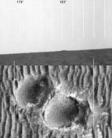
|
Posted by: Phil Stooke Mar 17 2010, 11:23 PM
"It's a flop-eared mule."
Mule? It's my pointy-haired boss appearing over the horizon to find out why I've accomplished nothing all week.
Phil
Posted by: helvick Mar 17 2010, 11:53 PM
Accomplished nothing all week? CBC, Slashdot, Fark, The Register and a bunch more beg to differ. Richard Garriott owes you for finding his rover - ask him to tell your boss to give you a break,
Posted by: fredk Mar 18 2010, 12:53 AM
In principle that would work. The problem is that the Ears are so faint and indistinct that you'd have a hard time aligning them precisely. The result would probably be pretty blurred. Maybe we could try after the raws are publicly available.
Posted by: Tman Mar 18 2010, 06:42 PM
In today's Expl. update there're R2 filtered images of the drive direction. The twin craters location got quite a new look.
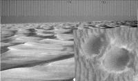
|
Additionally I plunged into full resolution and come up with a slightly shifted position for the craters. But as Fred said, all will be revealed soon enough.
Posted by: jamescanvin Mar 18 2010, 09:45 PM
OK I ended up shifting my identifications slightly from my last post on Bopolu (getting a better fit in the process I think) and then get a nice alignment with the highest peaks on the SE-Miyamoto rim according to GM.
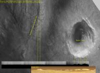
|
James
Posted by: ngunn Mar 18 2010, 10:07 PM
Fantastic work James. In anticipation I did some very rough calculations on those peaks. I think the visible 'Mule Ears' represent the top 100m or so of those mountains at a distance of approximately 80 km. Below that I estimate there is about 900m out of sight beyond the curvature of Mars. We only just see them, both geometrically and atmospherically. Nice.
Posted by: Stu Mar 18 2010, 10:20 PM
Lots of new images today... has Oppy been having a clear-out? Cobbled together this - I'm sure others will do better, I just liked the (vague) details visible on the hills...
|
|
Posted by: fredk Mar 18 2010, 10:23 PM
Most of them were old images, with the unusual suffix M7, identical to the corresponding M1's we've already got down. I don't know what that was about.
Posted by: Stu Mar 18 2010, 10:28 PM
You mean we'd seen them before, or they were taken sols ago, cos that's what I was meaning.
Posted by: john_s Mar 18 2010, 11:43 PM
Nice, James! A rather cool thing about this detection is that it bridges the very wide gap between what Oppy can see from the ground and what Hubble can see from Earth. Miyamoto is big enough that it's visible in Hubble images (or at least, associated albedo features can be seen). The red arrow on the attached 2001 HST image points to a pair of light and dark markings- the dark region is the southern floor of Miyamoto, the bright region below it is its southern rim. Thanks are due to Mike Howard- I used the Mars Globe iPhone app to make the connection.
[edit]- one more cool thing- Jim Bell was responsible for both images- he was PI on the Hubble program as well as being PanCam PI.
John

|
Posted by: Tman Mar 19 2010, 12:11 PM
Cool John, the glimpse of the Miyamoto region from Oppy makes a very nice bridge to Hubble.
The sharpest (ever) image from Hubble was captured in 2003 when Mars came to his close encounter with Earth http://hubblesite.org/newscenter/archive/releases/2003/22/image/d/ (...responsible J.Bell and M.Wolff)
You think Bopolu is even visible therein
For comparison an overview of the region from Mars Global Surveyor and a sharped Hubble piccrop:

|

|
Posted by: ngunn Mar 19 2010, 12:34 PM
I was wondering if there are any orbiter close-ups (if that's not a contradiction) of those SE rim peaks? They'd make another interesting target for Nirgal's shape-from-shading technique.
Posted by: Tman Mar 19 2010, 01:37 PM
Time to covering entirely the whole region with MRO! At the latest when Oppy rides the peaks of Endeavour
Posted by: tim53 Mar 19 2010, 03:17 PM
Folks:
Thanks for the heads-up on the possible visibility of Miyamoto! I hadn't noticed those, even though I have been trying to pay close attention to the horizon as we start rounding this "nose" in the topography.
-Tim.
Posted by: mhoward Mar 19 2010, 06:03 PM
You think Bopolu is even visible therein
Actually I think Endeavour may be visible in that Hubble photo. Amazing!
I really like this connecting the view from the ground to the view from Hubble. If I had time and the technical ability right now, I'd do a little movie, but instead here's a http://www.flickr.com/photos/marscat/sets/72157623527302243/. This is derived from Mars Globe, which uses a colorized version of the MOC atlas for albedo and a lighting map derived from the MOLA dataset.
Posted by: Bill Harris Mar 19 2010, 07:06 PM
The horizon view keeps getting better and better. I halfway expect to log on some day and see a view of the back of Oppy's head with Victoria in the foreground and Endeavour in the background...
--Bill
Posted by: Tesheiner Mar 19 2010, 08:48 PM
Knock on wood. We tried searching for VC on the latest north-looking pancams (Fredk?) and it was barely visible.
Posted by: fredk Mar 19 2010, 11:44 PM
This Miyamoto from Hubble stuff is seriously cool. Has anyone noticed Gusev in Hubble images?
Posted by: Bill Harris Mar 20 2010, 12:28 PM
Here is a comparison image that I cobbled together from images I found posted here on USMF. The background and righthand image are from Tman in Post #242 in this thread. The Background is a MGS Context image, the Righthand is a Hubble image. For the life of me, I can't find the Post# where I snagged the Lefthand image-- it is an MRO/DEM-Altimetric image of an MSL landing ellipse at Miyamoto crater.
At any rate:
Background: MGS
Right: Hubble
Left: MRO
All at the same relative scale.
--Bill

|
Posted by: ngunn Mar 20 2010, 12:44 PM
[quote name='Bill Harris' date='Mar 20 2010, 12:28 PM' post='157397']
Post#
206 FWIW
Can anyone with Google Earth Mars confirm whether HRSC is indeed currently the most detailed orbital imagery of the SE Miyamoto rim? I'm guessing it is since I haven't seen anything else posted.
Posted by: fredk Mar 20 2010, 03:27 PM
We really were on a bit of a ridge at Concepcion. The view of Endeavour etc has worsened considerably since then:
|
|
This should be temporary, though, and the view should improve again eventually...
Posted by: Tesheiner Mar 20 2010, 03:43 PM
Ngunn, I can't speak about HRSC.
But here's the map of HiRISE pictures covering the same area that you can find on this link: http://global-data.mars.asu.edu/

|
There's coverage to the east of Miyamoto, also some of Bopolu but none of the rim.
Nice work, fredk!
I expect that once we leave the twin craters --only a few hundreds of meters after, perhaps-- the view will get much better than the one we had at Concepción.
Posted by: djellison Mar 20 2010, 10:57 PM
There's just about complete CTX coverage of the whole of Miyamoto. Turn on the CTX imagery in Google Earth(mars), and you're ready to rock.
Posted by: ngunn Mar 20 2010, 11:21 PM
Great, but I don't have Google Earth Mars. Could somebody post the CTX of those rim peaks?
Posted by: djellison Mar 20 2010, 11:29 PM
There is raw data available, but map projected stuff isn't available (and it's not particularly hard, but it is fairly time consuming to make it)
http://viewer.mars.asu.edu/planetview/inst/ctx/P15_007058_1751_XI_04S006W#start
http://viewer.mars.asu.edu/planetview/inst/ctx/P13_005990_1786_XI_01S006W
http://viewer.mars.asu.edu/planetview/inst/ctx/P21_009207_1768_XI_03S005W#start
A starter for 10
HRSC offers the best stereo usually ( unless a HiRISE or CTX dem exists ) - but CTX imagery is far FAR better than HRSC imagery.
Posted by: ngunn Mar 20 2010, 11:53 PM
Well, there they are in the middle one. Thanks Doug. Now - 3D?
Posted by: ngunn Mar 21 2010, 09:49 AM
Are you there Nirgal?
Here's the area of interest cropped from the browse version. The original has MUCH more detail.
Posted by: ngunn Mar 23 2010, 04:14 PM
OK we have the Mule Ears identified, but that still leaves 'Rockaway', the nearer feature to the right of them. We've been assuming it's quite close, therefore small, therefore (since it's off the edge of the HiRise) probably unidentifiable with only CTX. However I've been monitoring small changes in the angular separation of the Mule Ears and 'Rockaway' as we move south. The results of some extremely crude and approximate calculations surprised me. I came up with a distance of 9 kilometres. This would make it's diameter about 60m, which should be easy to find on CTX. So I looked for the CTX and checked out what lies about 9km away on a bearing of 198 degrees. Not too far from that position - lo and behold - a small dark spot which appears to have rays. Now I'm only looking at a browse version of the CTX, plus my measurements and calculations are as I say very rough, so I'd appreciate if someone else could check this out.
This would mean the flat horizon we are seeing in front of the Mule Ears and Bopolu is probably Mars-curvature limited, not topography limited, consistent with the contour map. (When I thought 'Rockaway' was much nearer it bothered me that there should be no hill there for it to sit on.)
http://photojournal.jpl.nasa.gov/jpeg/PIA11837.jpg
EDIT It's at the centre of this crop:
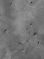
|
Posted by: fredk Mar 23 2010, 05:49 PM
I agree with your ID of "rockaway". Here's a closer view of it - it looks pretty fresh:
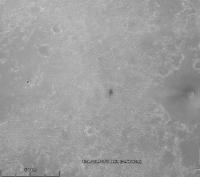
|
Both the azimuth and the size look right. This crater would subtend about half a degree from our current location, which is what we see. The distance also looks believable, since the horizon on either side of it looks very flat, which suggests it's very far away.
Posted by: Tman Mar 23 2010, 06:41 PM
Yes, the azimuth heading matchs perfectly in your image. Great finding! The rim must be pretty developed.
I have an "not suitable for measurements" image with better resolution" that I'dont know from where it came onto my disk". Here the detail:
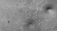
|
Posted by: Tesheiner Mar 23 2010, 06:55 PM
Looking to the vertical strips on the image I would say that it looks like from CTX.
Posted by: Tman Mar 23 2010, 09:53 PM
Yup http://viewer.mars.asu.edu/planetview/inst/ctx#/planetview/inst/ctx/P21_009141_1780_XI_02S005W
List http://viewer.mars.asu.edu/planetview/inst/ctx#/planetview/results?instrument=ctx&minlongitude=354&maxlongitude=358&minlatitude=-1&maxlatitude=-3
Posted by: ngunn Mar 23 2010, 10:34 PM
Anyone got the actual distance measured? I only know it approximately from laying a plastic ruler on my monitor screen and using the size of Victoria as a guide.
Posted by: fredk Mar 23 2010, 10:42 PM
About 7.5 km from current location to rockaway.
Posted by: ngunn Mar 23 2010, 10:50 PM
Thanks
Posted by: Tesheiner Mar 24 2010, 09:23 PM
After reading the http://www.planetary.org/blog/article/00002407/ pointed by http://www.unmannedspaceflight.com/index.php?s=&showtopic=6434&view=findpost&p=157563, I rushed to the HiRISE website to search for the whole picture used at the article and with the following idea in mind: "maybe the 'rockaway' crater is visible on that picture". This new HiRISE image (http://hirise.lpl.arizona.edu/ESP_016644_1780) cover much more land to the left then previous ones, way west of the twins, but unfortunately it misses rockaway by a small fraction.
Here's an image crop at browse resolution to compare with the one used in your post.
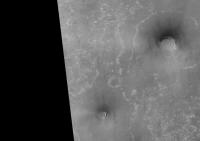
|
Posted by: Stu Mar 30 2010, 10:03 PM
Today's vista...
|
|
Posted by: RokitSiNTst Mar 30 2010, 10:11 PM
Stu, there is another on the horizon of this image http://qt.exploratorium.edu/mars/opportunity/navcam/2010-03-30/1N323231461EFFAEI4P1977R0M1.JPG (Bopolu, plus the other twin peaks)
Posted by: ngunn Mar 30 2010, 10:42 PM
Which features are you referring to here and where are they in the image?
Posted by: Ant103 Mar 30 2010, 11:17 PM
In colors
http://www.db-prods.net/marsroversimages/Opportunity/2010/Sol2197-pancam.jpg
Posted by: RokitSiNTst Mar 31 2010, 12:18 AM
Twin peaks II (Miyamoto crater?) far right, another small crater center.

|
Twin Peaks II (Miyamoto crater?) far left, Bopolu(?) just to the right of them.

|
4x vertical stretch.
Posted by: fredk Mar 31 2010, 02:52 AM
Close. What you're calling Twin Peaks II is part of Bopolu. Your "small crater" is Rockaway. The "Mule ears" aren't visible in navcam.
Posted by: ngunn Apr 13 2010, 07:55 AM
The clearest view yet of the Mule Ears, and maybe one of the last for a while as we're now facing eastward.
http://qt.exploratorium.edu/mars/opportunity/pancam/2010-04-12/1P324027413EFFAF00P2409R1M1.JPG
I think I can see the notch in the right one that also shows in James's Google view:
http://www.unmannedspaceflight.com/index.php?act=attach&type=post&id=21125
Posted by: ngunn Apr 19 2010, 09:06 AM
The distant southern horizon looks surprisingly curved now:
http://qt.exploratorium.edu/mars/opportunity/pancam/2010-04-19/1P324834304EFFAFTQP2413R1M1.JPG
Is this the effect of the regional downslope to the SE ?
Posted by: Phil Stooke Apr 19 2010, 11:06 AM
There's only one way to investigate that... astigmovision:
|
|
Looks like we will see some details on the plains if the air clears more, or when we have the raw data. The relief is starting to show up well.
Phil
Posted by: ngunn Apr 19 2010, 11:10 AM
Vertical stretch of the curved horizon: EDIT You beat me by 4 minutes Phil!
Posted by: Tman Apr 19 2010, 12:01 PM
In the adjacent image to the left the plain becomes also visible behind the dune field: http://qt.exploratorium.edu/mars/opportunity/pancam/2010-04-19/1P324834109EFFAFTQP2413R1M1.JPG
Ohh uhh: http://qt.exploratorium.edu/mars/opportunity/pancam/2010-04-19/1P324833925EFFAFTQP2413R1M1.JPG
Very nice and additionally a new remote (?) crater puzzle

|
Posted by: Phil Stooke Apr 19 2010, 01:08 PM
All three frames put together.
Phil
|
|
Posted by: ngunn Apr 19 2010, 01:33 PM
Very nice, Phil. I suppose the most distant part of the flat horizon now coming into view must actually be a fraction of a degree below the theoretical horizon, which ought to be closer in level to the plateau on the right. I'm not used to such views because all the large regional dips in my part of Terra are full of seawater.
Posted by: fredk Apr 19 2010, 01:38 PM
Great views! We're already seeing a bit more of Iazu than we did at Concepcion, and as Phil's stretch shows, we still haven't cleared the ridge up ahead.
The perspective has changed substantially since Concepcion. Here's a long-baseline anaglyph combining sol 2160 (Concepcion) and 2215 views. The dark bits in front of Iazu clearly stand out in front:
|
|
Posted by: fredk Apr 19 2010, 01:57 PM
The new bit you're referring to (near azimuth 155 on your horizon mosiaic) looks hazier than Iazu, so presumably farther away. My guess is we're seeing a bit of the rim of the big crater behind Iazu, marked with the white arrow in this view:

|
Posted by: ngunn Apr 19 2010, 02:31 PM
I agree. Another peak-matching exercise for James. . Does it have an official name? (Looking forward to viewing your Iazu anaglyph when I get home to a computer that doesn't mess up the colours.)
Posted by: vikingmars Apr 19 2010, 02:51 PM
|
|
Posted by: Phil Stooke Apr 19 2010, 03:30 PM
Ah yes, good times... good times.... the old Viking days.
Phil
Posted by: Burmese Apr 19 2010, 05:32 PM
marsroverdriver today:
"Keep an eye on http://marsrovers.jpl.nasa.gov/gallery/all/opportunity.html for when B-2215 (Oppy weekend drive) images show up: PANCAM got nice images of Endeavour on far horizon"
Posted by: ngunn Apr 21 2010, 07:50 AM
Finally the distant southern skyline is fully revealed, all the way from Iazu to the Mule Ears.
http://qt.exploratorium.edu/mars/opportunity/pancam/2010-04-21/
EDIT: And in the third image, near the bottom of the slope down from the 'rockaway plateau' to the lower plains, there are a few dark pixels close to the horizon whch could be another middle-distance fresh crater. A wild guess: there is another dark spot about 5 km SE of Rockaway here:
http://www.unmannedspaceflight.com/index.php?act=attach&type=post&id=21169. That one should be on the Hirise I think.
I've pointed to the feature here:
Posted by: nprev Apr 21 2010, 08:30 AM
Odd but evocative to see surface relief rising more rapidly now from Oppy's viewpoint. It's a bit like driving across the North American Great Plains & approaching the Rockies.
Posted by: Astro0 Apr 21 2010, 11:26 AM
Panorama
|
|
and...
some extreme Phil-O-Vision

|
Posted by: Tesheiner Apr 21 2010, 02:21 PM
The view is becoming really beautiful.
I'm wondering if it will be possible to see Santa Maria (mini-Endurance) once we are clear of this local high point.
Posted by: Stu Apr 21 2010, 02:31 PM
Wow... I come home from work, log on and see... The Future...
I haven't been as excited by such a view since we first peered over the edge of Victoria Crater.
And I have to be honest... seeing the Hills from top to bottom like that, this is the first time I've actually, truly believed Oppy will eventually reach them.
Fanciful view - and please, no-one say "ooh, the Sun could never be there!" if the viewing geometry is wrong; it's just to evoke the sense of wonder I'm feeling right now...
|
|
Posted by: jamescanvin Apr 21 2010, 02:45 PM
Reach Iazu? You're beginning to sound like Rui!
Posted by: Stu Apr 21 2010, 03:22 PM
Speaking generally, James, not literally. I think we're on for Endeavour, but that will be it.
Posted by: Tman Apr 21 2010, 03:27 PM
Ok, I do not say "what is the height of the sun there about? 10 degrees? Then the southest azimuth point of the sun around in the early morning can be about 115 degrees for Oppy (at Ls 270°). Therefore probably more realistic with one of the peaks of Endeavour"
Either way a nice "atmospheric" composition (of course).
Posted by: Stu Apr 21 2010, 03:44 PM
One of my favourite Ansell Adams quotes is:
"Sometimes I do get to places just when God's ready to have somebody click the shutter."
My version:
"Sometimes Oppy gets to places when God's got the details just a little bit wrong, so I rearrange them"...
Posted by: ngunn Apr 21 2010, 09:19 PM
My guess is yes, and quite soon. I'm expecting it to appear about twice the size of Rockaway and slightly below the (plains) horizon in front of Endeavour. I'm still getting my head round the fact that we're looking down on all this stuff and the theoretical horizon is up in the sky somewhere.
Posted by: climber Apr 21 2010, 10:41 PM
I'm wondering if it will be possible to see Santa Maria (mini-Endurance) once we are clear of this local high point.
I have the feeling we'll have a kind of "Everest panorama" in the near future, yet different, but kind of same inspiration.
Posted by: Ron Hobbs Apr 21 2010, 11:28 PM
I think you are absolutely right, climber, though I think it will be more reminiscent of northern Arizona or New Mexico. I think this will be one that would excite Ansel Adams.
(Not that the Everest pan wouldn't. )
Posted by: Tesheiner Apr 22 2010, 05:43 AM
I'm really looking forward such panorama!
Meanwhile, I checked the tracking web for thisol and further imaging/driving plans and found this sequence planned for tomorrowsol (2220):
02220::p2415::24::6::0::0::6::1::13::pancam_Endeavour_movie_L257
Any ideas?
Posted by: Stu Apr 22 2010, 05:53 AM
Maybe a pan of colour images, taking in the view all around..? Set to the theme from "The Big Country"?
Powered by Invision Power Board (http://www.invisionboard.com)
© Invision Power Services (http://www.invisionpower.com)