Crossing the Dunes at Murray Buttes, Sites 54-62, Sols 1353-1659, May 28 2016-Apr 6 2017 |

  |
Crossing the Dunes at Murray Buttes, Sites 54-62, Sols 1353-1659, May 28 2016-Apr 6 2017 |
 Jan 9 2017, 10:39 PM Jan 9 2017, 10:39 PM
Post
#856
|
||
 Senior Member  Group: Members Posts: 2428 Joined: 30-January 13 From: Penang, Malaysia. Member No.: 6853 |
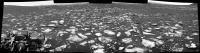
1574 partial (horizon) NavCam after another drive. Reported by Midnight Planets as ~26.0m SE
EDIT Curiosity Update for Sol 1575 From Ken Herkenhoff: Investigating Dorr Mountain: QUOTE After a 25-meter drive on Sol 1574, MSL again has bedrock exposed in her arm workspace. To balance desires to sample the composition of the rocks along the traverse and to make good progress toward the south, contact science and another drive are both planned for Sol 1575. First, MAHLI will acquire a full suite of images of a knobbly bedrock target named "Dorr Mountain." Then the arm will be stowed to allow ChemCam to observe the same target and for the Right Mastcam to acquire a 5x2 mosaic of the Dorr Mountain area. Navcam will search for dust devils before the drive begins. After the drive, the arm will be unstowed to allow Navcam stereo imaging of the arm workspace, in anticipation of another "touch and go" plan tomorrow.
|
|
 |
 
|
|
|
Jan 11 2017, 01:03 AM
Post
#857
|
||
|
Senior Member Group: Members Posts: 2428 Joined: 30-January 13 From: Penang, Malaysia. Member No.: 6853 |
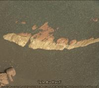
The yellow / red colour boundary at the target named 'Isle Au Haut' by JPL captured in this R-MastCam frame from 1574, no colours adjusted. I'll add a 1572 MAHLI with a scale bar to the next post.
|
|
|
|
|
|
|
Jan 11 2017, 01:06 AM
Post
#858
|
||
|
Senior Member Group: Members Posts: 2428 Joined: 30-January 13 From: Penang, Malaysia. Member No.: 6853 |
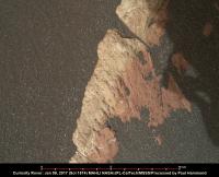
Impressive colour contrast on this outcrop dubbed 'Isle Au Haut' by JPL. Raw colours no processing.
A MAHLI from 1572 with scale bar based on the focus count (thanks to Gerald)
|
|
|
|
|
|
|
Jan 11 2017, 02:29 AM
Post
#859
|
|
|
Senior Member Group: Members Posts: 1074 Joined: 21-September 07 From: Québec, Canada Member No.: 3908 |
Sol 1574 Rmastcam view of a group of rocks:

|
|
|
|
|
Jan 11 2017, 02:44 PM
Post
#860
|
||
|
Senior Member Group: Members Posts: 2819 Joined: 22-April 05 From: Ridderkerk, Netherlands Member No.: 353 |
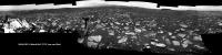
The complete Navcam L view on Sol 1574.
Jan van Driel
|
|
|
|
|
|
|
Jan 11 2017, 03:56 PM
Post
#861
|
||
|
Senior Member Group: Members Posts: 2819 Joined: 22-April 05 From: Ridderkerk, Netherlands Member No.: 353 |
The Navcam L panoramic view on Sol 1575.
Jan van Driel
|
|
|
|
|
|
|
Jan 11 2017, 07:43 PM
Post
#862
|
|
|
Member Group: Members Posts: 910 Joined: 4-September 06 From: Boston Member No.: 1102 |
Exact same spot, but got better view of horizon--nice.
-------------------- |
|
|
|
|
Jan 11 2017, 09:10 PM
Post
#863
|
||
|
Senior Member Group: Members Posts: 2428 Joined: 30-January 13 From: Penang, Malaysia. Member No.: 6853 |
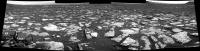
Partial L-NavCam Pano after the touch and go on sol 1576. Midnight Planets reports the drive as ~29.4m SE
Takes us a little closer to the butte called 'Ireson Hill'  Maybe they'll grab a couple of R-MastCam's soon to see what awaits us there Maybe they'll grab a couple of R-MastCam's soon to see what awaits us there
|
|
|
|
|
|
|
Jan 11 2017, 09:36 PM
Post
#864
|
|||
|
Solar System Cartographer Group: Members Posts: 10150 Joined: 5-April 05 From: Canada Member No.: 227 |
A good drive for Curiosity on sol 1576. Here are before and after images, before the drive from Jan's panorama and after it from Paul's half-panorama.
Phil -------------------- ... because the Solar System ain't gonna map itself.
Also to be found posting similar content on https://mastodon.social/@PhilStooke NOTE: everything created by me which I post on UMSF is considered to be in the public domain (NOT CC, public domain) |
||
|
|
|
||
|
Jan 11 2017, 10:34 PM
Post
#865
|
|
|
Senior Member Group: Members Posts: 2428 Joined: 30-January 13 From: Penang, Malaysia. Member No.: 6853 |
Really enjoy those Philovision views
USGS Update Sol 1576: Arm fault QUOTE MSL planning started 2 hours later than usual today because the Sol 1575 data needed for planning weren't expected until almost 10 AM PST. Unfortunately, the news was not good: An arm fault prevented the MAHLI full suite from completing, leaving the camera close to the surface with its dust cover open. The remote science and drive that were planned to follow were also precluded. Fortunately, this fault has occurred before and is well understood, but recovering from the anomaly made for a rather hectic day for me as SOWG Chair! The first order of business was to get MAHLI into a safe configuration, so the Sol 1576 plan starts with a single MAHLI image to look for evidence of dust on the exposed optics. Front Hazcam images will be taken before and after MAHLI is retracted from the surface, then Right Mastcam will take a picture of MAHLI's optics, again to look for dust contamination. Finally, the MAHLI dust cover will be closed and APXS placed on Dorr Mountain for a short integration. The arm will then be stowed and Right Mastcam will acquire a 5x1 mosaic of a distant mesa named "Lobster Mountain." ChemCam and Right Mastcam will observe Dorr Mountain and a bedrock target dubbed "Parkman Mountain," and Left Mastcam will take another image of the rover deck to monitor changes in the dust and sand on the deck. Mastcam will also measure the amount of dust in the atmosphere before the drive is attempted again. We don't expect as much data as usual in time for planning the next Sol, so we had to carefully prioritize the post-drive imaging, which includes another Navcam stereo pair of the arm workspace. Later in the Sol, ChemCam will autonomously observe a target selected by the AEGIS software. Finally, the rover will recharge overnight to get ready for more fun on Sol 1577. EDIT USGS Update Sol 1577: Another Touch & Go QUOTE MSL drove almost 30 meters on Sol 1576, stopping in a location with a nice exposure of bedrock in the arm workspace. MAHLI's optics look clean, so we planned a full suite of MAHLI images and a short APXS integration on a bedrock target named "Mansell Mountain." Fitting the remote sensing observations we wanted, along with the contact science and a ~46-meter drive, into the Sol 1577 plan was a challenge. But the tactical team did a great job, working together to put together an excellent plan. After the contact science is completed, ChemCam and Right Mastcam will observe an odd cobble called "Ames Knob" and a bedrock target dubbed "Day Mountain." Left Mastcam will acquire a 2-image mosaic of the bedrock slab in front of the rover, and Right Mastcam will take an image of the Sol 1576 AEGIS target and a 4x1 mosaic of a layered exposure named "Appleton Ridge." After the drive and the post-drive imaging needed to plan Sol 1578 activities, Navcam will acquire a panorama and search for dust devils and clouds. It's been a busy day for me as SOWG Chair! |
|
|
|
|
Jan 12 2017, 09:21 PM
Post
#866
|
||
|
Senior Member Group: Members Posts: 2428 Joined: 30-January 13 From: Penang, Malaysia. Member No.: 6853 |
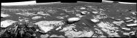
Partial L-NavCam Pano after the touch and go on sol 1577. Midnight Planets reports this drive as ~45.6m SSE (148º)
|
|
|
|
|
|
|
Jan 13 2017, 03:23 PM
Post
#867
|
||
|
Senior Member Group: Members Posts: 2819 Joined: 22-April 05 From: Ridderkerk, Netherlands Member No.: 353 |
The complete Navcam L view on Sol 1576.
Jan van Driel
|
|
|
|
|
|
|
Jan 13 2017, 04:25 PM
Post
#868
|
||
|
Solar System Cartographer Group: Members Posts: 10150 Joined: 5-April 05 From: Canada Member No.: 227 |
Another drive on sol 1578. From reprojected Hazcams:
I would estimate a 30 m drive SSW, but I do not have an exact position yet. Phil -------------------- ... because the Solar System ain't gonna map itself.
Also to be found posting similar content on https://mastodon.social/@PhilStooke NOTE: everything created by me which I post on UMSF is considered to be in the public domain (NOT CC, public domain) |
|
|
|
|
|
|
Jan 13 2017, 04:48 PM
Post
#869
|
||
|
Senior Member Group: Members Posts: 2819 Joined: 22-April 05 From: Ridderkerk, Netherlands Member No.: 353 |
The Panoramic Navcam L view on Sol 1577.
Jan van Driel
|
|
|
|
|
|
|
Jan 13 2017, 08:42 PM
Post
#870
|
||
 Member Group: Members Posts: 334 Joined: 11-December 12 From: The home of Corby Crater (Corby-England) Member No.: 6783 |
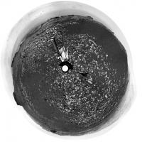
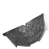
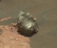
Great meteorite image from sol 1577
You wait around god knows how long and the first thing you meet shoots you. Three times!!! |
|
|
|
|
|
|

|
Lo-Fi Version | Time is now: 24th April 2024 - 05:04 PM |
|
RULES AND GUIDELINES Please read the Forum Rules and Guidelines before posting. IMAGE COPYRIGHT |
OPINIONS AND MODERATION Opinions expressed on UnmannedSpaceflight.com are those of the individual posters and do not necessarily reflect the opinions of UnmannedSpaceflight.com or The Planetary Society. The all-volunteer UnmannedSpaceflight.com moderation team is wholly independent of The Planetary Society. The Planetary Society has no influence over decisions made by the UnmannedSpaceflight.com moderators. |
SUPPORT THE FORUM Unmannedspaceflight.com is funded by the Planetary Society. Please consider supporting our work and many other projects by donating to the Society or becoming a member. |
|