The Geology of Jezero Crater, Observations & Findings |

  |
The Geology of Jezero Crater, Observations & Findings |
 Mar 1 2021, 03:23 AM Mar 1 2021, 03:23 AM
Post
#46
|
|
 Newbie  Group: Members Posts: 15 Joined: 24-July 11 From: Cumberland Plateau Member No.: 6084 |
If caves created by ancient running waters
existed in this region, would they have likely already been spotted by orbital imaging? Far as I know, all Martian caves known so far are attributed to vulcanism, right? |
 |
 
|
|
Mar 1 2021, 02:24 PM
Post
#47
|
||
 Member Group: Members Posts: 684 Joined: 24-July 15 Member No.: 7619 |
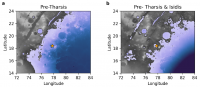
Hat tip to serpens for finding a paper about coastlines of 2 possible high stands of Mar's northern ocean.
QUOTE (serpens) An interesting abstract from LPSC 2021 which includes... The paper is https://www.hou.usra.edu/meetings/lpsc2021/pdf/1605.pdf QUOTE ARE WE VISITING THE COASTLINES OF MARS? LOAD-CORRECTED PALEO-OCEAN LEVELS AT JEZERO, OXIA PLANUM, AND GALE. R. I. Citron , M. Manga , D. Hemingway and A. Plattner Link to one of papers cited as a reference in the LPSC 2021 paper QUOTE Lithospheric structure and tectonics at Isidis Planitia, Mars J. Andreas Ritzer ∗, Steven A. Hauck, II -2009 https://artscimedia.case.edu/wp-content/upl...icarus_2009.pdf The paper also 'raises' three interesting possibility about Jezro crater. First, Jezro appears to have formed at the shoreline of Mar's highest northern ocean, the basin floor could have been below sea level. Very interesting - were the oceans around long enough to become salty? Second, Crustal deformation associated with the Tharsis bulge & Isidris gravity anomaly appears to have caused the area of Isidris where Jezro crater is to slowly sink almost 2km. Very interesting to ask whether Jezro dropped fast enough that it might have occasionally been under the waves of the northern ocean. A very interesting side effect of the entire Isidris basin slowly dropping is that it might have preserved many layers of shallow water sediments, which is VERY interesting for recreating climate records. A similar situation (slowly sinking land creates a long-lived but always shallow lake which records climate changes) is what is being used to turn Van Hounten cycles into a"Geological Orrey" to determine the parameters of Earth's orbit millions of years ago. Finally, Jezro appears to have remained above the 2nd northern ocean, but water flowing through Jezro ending up in an inland sea filling the Isidris basin.
Attached thumbnail(s)
|
|
|
|
|
|
|
Mar 1 2021, 07:21 PM
Post
#48
|
|
|
Member Group: Members Posts: 248 Joined: 25-February 21 From: Waltham, Massachussetts, U.S.A. Member No.: 8974 |
QUOTE (serpens @ Feb 28 2021, 05:42 PM)  This post correlates to Demko's post #392 in the Perseverance Lands In Jezero Crater thread. The direction of sediment flow raised by Tim's assessment has implications for the original size and configuration of the delta and potentially interactions between the two deltas. Yes, agreed. I was more cautious in my interpretation but had the same impression regarding the lower set of foresets, in the shaded, right portion. In fact, I think now that the lower massive bed can be traced all the way to the base of the cliff on the right side where it is exposed again. There is the implication that there were two large scale cycles of progradation followed by regression and possibly erosion which is very typical and commonly observed in terrestrial analogues. -------------------- --
Andreas Plesch, andreasplesch at gmail dot com |
|
|
|
|
Mar 1 2021, 09:19 PM
Post
#49
|
|
|
Senior Member Group: Members Posts: 1044 Joined: 17-February 09 Member No.: 4605 |
Perhaps just coincidence but the pre-Tharsis high stand coverage reflects the extent of olivine/carbonate deposits.
|
|
|
|
|
Mar 3 2021, 06:56 PM
Post
#50
|
|
|
Member Group: Members Posts: 240 Joined: 18-July 06 Member No.: 981 |
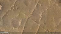
 A couple of things interest me here (inset of ESP_068294_1985_RED.jp2 on the HiRISE site - endlessly fascinating image) and was wondering what others think. The released proposed track goes well south of this area yet there is much to explore here a couple of km north of Perseverance and it look like it was quite dynamic geologically in the past. The circular volcano-like feature that I first thought was a mesa that had been separated from the main delta does not appear to be directly associated with the delta. It may have been formed by volcanism or some upwelling of plastic material other than magma. Looking closely at the plain surrounding the feature there is a network of linear fractures and a large apron of material extending to the west. To me this looks like an ice rink that has cracked up under the pressure of something very heavy. Maybe the mass of upwelled material? There is a very picturesque v-shaped bay (It looks like Jaws about to bite Brody) in the delta that looks tantalizing. There seems to be a clearly delineated interface between the upper delta at its base in the western end of the bay (pointy end of the V) and the lower unit. These seem to be distinct units and it would be great to get the supercam and other instruments on both. The southern arm of the bay is formed by an independent linear section of the delta that appears to have separated from the main body of the delta and created a narrow valley leaving a prominent butte at its head. It would be interesting to look at the walls of that valley more closely. There is also a partial crater at the northwestern end and a continuation of the valley beyond with another crater. these craters would give a closer look at the deeper stratification within the delta. Finally something else that fascinates me is the faint arcuate dark feature linking the larger crater to the east of the inset through two smaller craters to its northwest. Maybe just a coincidence, but its an interesting connection between these craters. I hope Percy gets there. Any other thoughts about interesting geologic targets? |
|
|
|
|
Mar 4 2021, 01:08 AM
Post
#51
|
||
|
Member Group: Members Posts: 866 Joined: 15-March 05 From: Santa Cruz, CA Member No.: 196 |
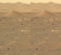
That seeming volcanic cone is quite distinct and intriguing. I recall there was perhaps a flyby of this area in one of Sean's videos in the last year or so. I suspect most of the faint linear features are likely sand dunes, with the larger arcuate feature seen perfectly intersecting through several craters looks like the trail vacuumed clean by a dust devil, it would be interesting to see if older imagery of the same area reveals seasonal differences in this and similar such features in the image. I'm curious if the cone, and perhaps also the similar chaotically eroded conic plateau just below to the left of it in this image that the arc leads to, may post-date delta formation.
[edit] Here I think is the view of that hill from Perseverance R mastcamZ, added in the left view for a parallel stereo to get sense of intervening terrain placement, the pancamZ segment is at far righthand of second teir in EliBonara's panorama linked in serpens' post below
|
|
|
|
|
|
|
Mar 4 2021, 01:53 AM
Post
#52
|
|
|
Senior Member Group: Members Posts: 1044 Joined: 17-February 09 Member No.: 4605 |
The cones are the product of aeolian erosion. There are a number of similar in EliBonora's treatment of the panorama on the Perseverance Lands In Jezero Crater thread post #425 with the link to the image in her flickr album being https://www.flickr.com/photos/lunexit/50995739733/
|
|
|
|
|
Mar 4 2021, 03:34 AM
Post
#53
|
|
|
Member Group: Members Posts: 240 Joined: 18-July 06 Member No.: 981 |
QUOTE (serpens @ Mar 4 2021, 02:53 AM) The cones are the product of aeolian erosion. There are a number of similar in EliBonora's treatment of the panorama on the Perseverance Lands In Jezero Crater thread post #425 with the link to the image in her flickr album being https://www.flickr.com/photos/lunexit/50995739733/ I'm not convinced of that due to the extensive apron of material at the base that has not eroded. Where would the rest of the surrounding material have gone?  Sand cones, yes I get that. But this has a prominent rocky base with no nearby continuation. Appears to just have popped up in the landscape.If it was a volcanic cone it would be a pretty small one. Would be amazing to see it up close. Atomoid, I think you are right The image above is the top of this volkini (mini volcano) I think. Once Percy gets closer to the apron to its north to look over the dune field to the west, it will see the base which is well below Percy's current viewpoint. Looking at the landing images the original proposed track would have depended on landing in the flat area that is now between Percy and the edge of the delta front. Now there are a lot of whipped cream dunes and tricky terrain to traverse to move further southwest. On the other hand, the path to the north looks pretty smooth and clear. The rightmost of the nearby crater twins (Twin E) offers a look at what the lower unit in this region consists of. The heat shield is very nearby that crater and would be a useful target for the materials engineers to get a look at. Then there is a wide open plain to the northwest of that crater leading towards the little volcano and the Jaw Bay I mentioned earlier. Between Percy and Twin E, there is a small outcrop as well that would be a useful first closeup look at the stratigraphy. I tried to find it in the panoramas but had difficulty. It s a very small prominence visible to the northwest of Percy on the way to Twin E. The path to the south looks similarly rough. So my vote is they start moving northward. I am thinking they will want to avoid dune fields at first and prefer flat open areas to test drive on. Once down in the plain at the foot of the delta, the driving should be easy and fast so any particular point will be quite accessible. Getting up on the delta will be quite an interesting exercise though. |
|
|
|
|
Mar 4 2021, 03:54 AM
Post
#54
|
|
|
Junior Member Group: Members Posts: 57 Joined: 20-January 12 From: Florida Member No.: 6317 |
The canyon at lower left in the picture in post #50 is interesting. A long dark valley, then a small crater, then what looks like the continuation of the valley. It reminds me of the pit chains that looks like partially open lava tubes. This one could have been carved by water except it looks black like the lava ones.
|
|
|
|
|
Mar 4 2021, 04:22 AM
Post
#55
|
|
|
Member Group: Members Posts: 240 Joined: 18-July 06 Member No.: 981 |
 Wouldn't that be one crazy vista? Imagine looking up at that dark vertical face from Percy's vantage point at the edge of the dune field by the foot. There is so much here. Caves? Strata in abundance. Toothy dunes arrayed radially. A half pipe at the crest. How tall is this according to the DEM? 50m? |
|
|
|
|
Mar 4 2021, 06:50 AM
Post
#56
|
|||
 Member Group: Members Posts: 714 Joined: 3-January 08 Member No.: 3995 |
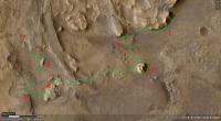
A portion of a possible traverse that would examine some really interesting features:
Points along the way are labeled: 1. First contact along the delta face. 2. Base of cliff below a major channel deposit. 3. Isolated remnant of delta. The images from the rover indicate a spectacular vertical outcrop, possibly displaying sedimentary structures of various kinds. 4. Possibly traversable section of sediments, which may include lake beds. 5. Very nice outcrop of possible lake deposits. 6. Another butte to explore on the way up to the delta's surface. 7. Strata outcrop along the entire way to the top. Stop 5 up close:
This is just utterly amazing. |
||
|
|
|
||
|
Mar 4 2021, 06:58 AM
Post
#57
|
||
|
Member Group: Members Posts: 714 Joined: 3-January 08 Member No.: 3995 |
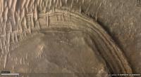
Would also like to examine some of these up close:
I'm guessing clastic dikes with alternately expanding and subsiding material. |
|
|
|
|
|
|
Mar 4 2021, 04:36 PM
Post
#58
|
|
|
Member Group: Members Posts: 684 Joined: 24-July 15 Member No.: 7619 |
QUOTE (atomoid @ Mar 4 2021, 01:08 AM) Here I think is the view of that hill from Perseverance R, added in the left view for a parallel stereo to get sense of intervening terrain placement, the pancamZ segment is at far righthand of second teir in EliBonara's panorama linked in serpens' post below Excellent work - That large image size is giving my eye-crossing muscles a bit of a workout though... One trick for anybody learning to see cross-eyed is to place you palm vertically in front of your nose. (Something I learned from viewing molecular bio papers that showed cross-eyed protein structures) |
|
|
|
|
Mar 4 2021, 04:51 PM
Post
#59
|
||
|
Member Group: Members Posts: 684 Joined: 24-July 15 Member No.: 7619 |
QUOTE (Gladstoner @ Mar 4 2021, 06:58 AM) Would also like to examine some of these up close:
I'm guessing clastic dikes with alternately expanding and subsiding material. Could also be good old normal jointing / faulting and later mineralization. The Isidris region may have had a 2 kilometer elevation drop due to slow crustal deformation from the weight of Tharsis plateau & the Isidris gravity anomaly/deposition. When you try and stretch rocks, they break into joints at fairly regular intervals, based on the material strength, so that MAY be a clue to whether the basement stone is weak mudstone or much stronger basalt/granite. |
|
|
|
|
|
|
Mar 4 2021, 08:31 PM
Post
#60
|
|
|
Forum Contributor Group: Members Posts: 1372 Joined: 8-February 04 From: North East Florida, USA. Member No.: 11 |
QUOTE (Gladstoner @ Mar 4 2021, 06:50 AM) A portion of a possible traverse that would examine some really interesting features:.. Looks like a lot of sand traps to me... |
|
|
|
|

|
Lo-Fi Version | Time is now: 30th May 2024 - 06:38 AM |
|
RULES AND GUIDELINES Please read the Forum Rules and Guidelines before posting. IMAGE COPYRIGHT |
OPINIONS AND MODERATION Opinions expressed on UnmannedSpaceflight.com are those of the individual posters and do not necessarily reflect the opinions of UnmannedSpaceflight.com or The Planetary Society. The all-volunteer UnmannedSpaceflight.com moderation team is wholly independent of The Planetary Society. The Planetary Society has no influence over decisions made by the UnmannedSpaceflight.com moderators. |
SUPPORT THE FORUM Unmannedspaceflight.com is funded by the Planetary Society. Please consider supporting our work and many other projects by donating to the Society or becoming a member. |
|