Chang'e 3 landing and first lunar day of operations, Including landing site geology and localization |

  |
Chang'e 3 landing and first lunar day of operations, Including landing site geology and localization |
 Dec 2 2013, 10:01 AM Dec 2 2013, 10:01 AM
Post
#1
|
|
 Member  Group: Members Posts: 123 Joined: 3-September 12 From: Almeria, SE Spain Member No.: 6632 |
Interesting speculation by the LROC team about a possible landing place near crater Laplace A:
A Great Place to Rove! Chang'E/Yutu could land about 10km south east, then (the rover) cross a wrinkle-ridge and reach the rim of the 8km crater. Thorsten (this is my first name, Denk is the family name) |
 |
 
|
|
Dec 2 2013, 11:58 AM
Post
#2
|
|
 Senior Member Group: Members Posts: 2428 Joined: 30-January 13 From: Penang, Malaysia. Member No.: 6853 |
QUOTE (Thorsten Denk @ Dec 2 2013, 06:01 PM)  Interesting speculation by the LROC team about a possible landing place near crater Laplace A: ...A Great Place to Rove!... Welcome Thorsten  During the Chinese cntv.cn coverage the commentators disused the landing site : the 'Bay of Rainbows'. Sinus Iridum is Latin for "Bay of Rainbows" |
|
|
|
|
Dec 2 2013, 09:09 PM
Post
#3
|
|
|
Member Group: Members Posts: 149 Joined: 18-June 08 Member No.: 4216 |
Looking at the lovely picture of Sinus Iridum a few posts back,
I wonder if the rim of the original crater is supposed to be somewhere under the lava plain and whether the subsurface radar of the rover could pick it up. |
|
|
|
|
Dec 2 2013, 09:29 PM
Post
#4
|
|
|
Solar System Cartographer Group: Members Posts: 10162 Joined: 5-April 05 From: Canada Member No.: 227 |
Yes, it would be under the plains, but probably too deep to be detected. I am more interested in a different possibility - there's a bright/dark boundary between two different mare units, best seen in Clementine data (I posted a false color version higher up the thread). If they land near the boundary and drive over it they may be able to detect the underlying unit beneath the overlying one and get the thickness of the top unit. In fact they may get thichnesses of multiple flow units.
Phil -------------------- ... because the Solar System ain't gonna map itself.
Also to be found posting similar content on https://mastodon.social/@PhilStooke Maps for download (free PD: https://upload.wikimedia.org/wikipedia/comm...Cartography.pdf NOTE: everything created by me which I post on UMSF is considered to be in the public domain (NOT CC, public domain) |
|
|
|
|
Dec 3 2013, 01:18 AM
Post
#5
|
||
|
Solar System Cartographer Group: Members Posts: 10162 Joined: 5-April 05 From: Canada Member No.: 227 |
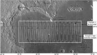
This map shows the extent of the landing region, extending quite far outside Sinus Iridum as well as inside it, and the coverage by Chang'E 2 at about 1.5 m/pixel. When we know where the landing will take place I will be adding more maps to zoom in on the site.
PS - for scale, 5 degrees of latitude is 150 km. Phil
-------------------- ... because the Solar System ain't gonna map itself.
Also to be found posting similar content on https://mastodon.social/@PhilStooke Maps for download (free PD: https://upload.wikimedia.org/wikipedia/comm...Cartography.pdf NOTE: everything created by me which I post on UMSF is considered to be in the public domain (NOT CC, public domain) |
|
|
|
|
|
|
Dec 3 2013, 03:13 AM
Post
#6
|
|
|
Senior Member Group: Members Posts: 2085 Joined: 13-February 10 From: Ontario Member No.: 5221 |
Planning a 'Yutu route map' sticky thread Phil?
 For what it's worth, the LROC team says they'll be photographing the site a few weeks after landing the 25th, January 22nd, and February 18th) http://lroc.sese.asu.edu/news/index.php?/a...;.html#extended |
|
|
|
|
Dec 3 2013, 05:37 AM
Post
#7
|
|
 Senior Member Group: Members Posts: 3419 Joined: 9-February 04 From: Minneapolis, MN, USA Member No.: 15 |
QUOTE (Explorer1 @ Dec 2 2013, 09:13 PM) Planning a 'Yutu route map' sticky thread Phil? You know, that may not be a bad idea. Depending on the volume of images we get from the Chinese, it may be possible to follow the traverse somewhat real-time. I would imagine we will have to wait to see if we get enough imagery to warrant it, but I'm beginning to think that we may need a dedicated Chang'e/Yutu folder, just as each of the Mars rovers has its own folder and LRO has its own folder, etc. I am just on pins and needles waiting to see our first new lunar surface vista in decades! -the other Doug -------------------- The trouble ain't that there is too many fools, but that the lightning ain't distributed right. -Mark Twain
|
|
|
|
|
Dec 3 2013, 05:23 PM
Post
#8
|
|
|
Solar System Cartographer Group: Members Posts: 10162 Joined: 5-April 05 From: Canada Member No.: 227 |
I guess I wasn't subtle enough! Yes, I am planning to map the route - whether in its own thread or not, and that may depend on image access. I am collecting material for a new Moon atlas and this will be part of it.
I will rely very much on our very helpful Chinese contributors for pointing out new articles and other information, translating names of features in the landscape etc. Phil -------------------- ... because the Solar System ain't gonna map itself.
Also to be found posting similar content on https://mastodon.social/@PhilStooke Maps for download (free PD: https://upload.wikimedia.org/wikipedia/comm...Cartography.pdf NOTE: everything created by me which I post on UMSF is considered to be in the public domain (NOT CC, public domain) |
|
|
|
|
Dec 3 2013, 05:32 PM
Post
#9
|
|
 Junior Member Group: Members Posts: 28 Joined: 1-July 13 From: United Kingdom, England Member No.: 6965 |
This will be interesting. I remember seeing a long while ago the High definition video from the probe that went around the moon years ago. Good Stuff.
|
|
|
|
|
Dec 3 2013, 06:01 PM
Post
#10
|
|
|
Senior Member Group: Members Posts: 3419 Joined: 9-February 04 From: Minneapolis, MN, USA Member No.: 15 |
With today's imaging technology, I'm hoping for HD video from the lander of the landing itself, and also of Yutu deployment and operations.
-the other Doug -------------------- The trouble ain't that there is too many fools, but that the lightning ain't distributed right. -Mark Twain
|
|
|
|
|
Dec 3 2013, 07:45 PM
Post
#11
|
|
|
Member Group: Members Posts: 149 Joined: 18-June 08 Member No.: 4216 |
QUOTE (Phil Stooke @ Dec 2 2013, 09:29 PM) Yes, it would be under the plains, but probably too deep to be detected. I am more interested in a different possibility - there's a bright/dark boundary between two different mare units, best seen in Clementine data (I posted a false color version higher up the thread). If they land near the boundary and drive over it they may be able to detect the underlying unit beneath the overlying one and get the thickness of the top unit. In fact they may get thichnesses of multiple flow units. Phil So, Chang'e/Yutu will be landing/roving on top of a geologic sandwich. |
|
|
|
|
Dec 6 2013, 10:51 AM
Post
#12
|
|
|
Junior Member Group: Members Posts: 64 Joined: 15-June 12 From: Hong Kong Member No.: 6419 |
Per latest Chinese reports:
Lunar landing is planned at 15:22-15:35 UTC on December 14. The rover should be deployed from the lander at 20:38-22:21 UTC on the same day. Then some time within the communication window on December 15 at 07:21-15:38 UTC, the lander and rover will photograph each other Source -------------------- UMSF - the place of Opportunity to satisfy your Spirit of Curiosity via Perseverance
|
|
|
|
|
Dec 10 2013, 09:03 PM
Post
#13
|
|
 Member Group: Members Posts: 568 Joined: 20-April 05 From: Silesia Member No.: 299 |
At 9:24 pm, it was confirmed that Change-3 had entered the new orbit.
http://www.asianews.co/change-3-probe-move...er-to-the-moon/ It seems that all is well. -------------------- Free software for planetary science (including Cassini Image Viewer).
http://members.tripod.com/petermasek/marinerall.html |
|
|
|
|
Dec 10 2013, 10:02 PM
Post
#14
|
|
|
Solar System Cartographer Group: Members Posts: 10162 Joined: 5-April 05 From: Canada Member No.: 227 |
Yes, only 15 km high at about 45 degrees north. Not long now.
Phil -------------------- ... because the Solar System ain't gonna map itself.
Also to be found posting similar content on https://mastodon.social/@PhilStooke Maps for download (free PD: https://upload.wikimedia.org/wikipedia/comm...Cartography.pdf NOTE: everything created by me which I post on UMSF is considered to be in the public domain (NOT CC, public domain) |
|
|
|
|
Dec 12 2013, 02:43 PM
Post
#15
|
|
|
Solar System Cartographer Group: Members Posts: 10162 Joined: 5-April 05 From: Canada Member No.: 227 |
Time for a rather trivial prediction. Unless Chang'E 3 lands at the far eastern end of the mapped landing area, the mountain Promontorium Laplace will be visible on the horizon, barring small-scale local obstructions. That will help to give an idea of the location of the landing site quite quickly.
Phil -------------------- ... because the Solar System ain't gonna map itself.
Also to be found posting similar content on https://mastodon.social/@PhilStooke Maps for download (free PD: https://upload.wikimedia.org/wikipedia/comm...Cartography.pdf NOTE: everything created by me which I post on UMSF is considered to be in the public domain (NOT CC, public domain) |
|
|
|
|
Dec 12 2013, 03:59 PM
Post
#16
|
|
|
Senior Member Group: Members Posts: 1074 Joined: 21-September 07 From: Québec, Canada Member No.: 3908 |
According to my rough calculations, Promontorium Laplace should be visible from about 95km away. If Chang-e 3 lands near the mare ridge S-E of Laplace A, Prom. Laplace would barely be jutting above the horizon.
|
|
|
|
|
Dec 12 2013, 04:09 PM
Post
#17
|
|
 Member Group: Members Posts: 550 Joined: 1-May 06 From: Scotland (Ecosse, Escocia) Member No.: 759 |
QUOTE (Phil Stooke @ Dec 12 2013, 02:43 PM) Time for a rather trivial prediction. Hardly trivial, Phil, given the time you have spent staring at hill tops to determine the uncertain location of Luna 9, in this same quadrant of the moon! I look forward to seeing the summit of Promontorium Laplace on Saturday... |
|
|
|
|
Dec 12 2013, 04:20 PM
Post
#18
|
|
|
Member Group: Members Posts: 550 Joined: 1-May 06 From: Scotland (Ecosse, Escocia) Member No.: 759 |
This is orbital view of Promontorium Laplace taken by Apollo 15 from the South-South East (looking NNW), over the crater Helicon.
Promontorium Laplace from the SSE 
|
|
|
|
|
Dec 12 2013, 10:00 PM
Post
#19
|
|
|
Member Group: Members Posts: 123 Joined: 3-September 12 From: Almeria, SE Spain Member No.: 6632 |
Sunrise in Sinus Iridum!
I'm not an astrophotographer, but I couldn't resist to take some pictures. (18:54 UTC, downsized to 50% and cropped, original here.)  I was surprised how incredibly fascinating it is to be able to see with my own eyes (and a 10"-Dobson) the operation area of a human rover on another celestial body! Laplace A and the wrinkle ridge were easily visible. Go, Chang'E! Your landing area is now in sunlight! Thorsten |
|
|
|
|
Dec 12 2013, 10:05 PM
Post
#20
|
||
|
Solar System Cartographer Group: Members Posts: 10162 Joined: 5-April 05 From: Canada Member No.: 227 |
Very nice!
Joel Raupe, on Lunar Networks reports rumours that the landing site will be in the area shown here. Phil
-------------------- ... because the Solar System ain't gonna map itself.
Also to be found posting similar content on https://mastodon.social/@PhilStooke Maps for download (free PD: https://upload.wikimedia.org/wikipedia/comm...Cartography.pdf NOTE: everything created by me which I post on UMSF is considered to be in the public domain (NOT CC, public domain) |
|
|
|
|
|
|
Dec 13 2013, 08:18 AM
Post
#21
|
|
|
Junior Member Group: Members Posts: 64 Joined: 15-June 12 From: Hong Kong Member No.: 6419 |
Per latest Chinese reports the landing time has shifted to ~13:40 UTC (~8:40 am EST/5:40 am PST/9:40 pm in Beijing).
-------------------- UMSF - the place of Opportunity to satisfy your Spirit of Curiosity via Perseverance
|
|
|
|
|
Dec 13 2013, 01:13 PM
Post
#22
|
|
|
Member Group: Members Posts: 154 Joined: 21-April 05 From: Rochester, New York, USA Member No.: 336 |
Thanks Cosmic Penguin. Any update on the time coverage starts?
|
|
|
|
|
Dec 13 2013, 01:33 PM
Post
#23
|
|
|
Member Group: Members Posts: 153 Joined: 4-May 11 From: Pardubice, CZ Member No.: 5979 |
QUOTE (craigmcg @ Dec 13 2013, 02:13 PM) Thanks Cosmic Penguin. Any update on the time coverage starts? and / or any published pictures from Moon orbit or the transfer? |
|
|
|
|
Dec 13 2013, 01:59 PM
Post
#24
|
|
|
Senior Member Group: Members Posts: 1074 Joined: 21-September 07 From: Québec, Canada Member No.: 3908 |
I would be surprised if there were any live coverage, considering how secretive the Chinese are. We'll get an announcement after the landing has occurred, and, I hope, a couple of pictures, but I'm not holding my breath.
|
|
|
|
|
Dec 13 2013, 02:08 PM
Post
#25
|
|
|
Member Group: Members Posts: 123 Joined: 3-September 12 From: Almeria, SE Spain Member No.: 6632 |
Launch had a fantastic two-hours live coverage...
|
|
|
|
|
Dec 13 2013, 02:24 PM
Post
#26
|
|
|
Member Group: Members Posts: 550 Joined: 1-May 06 From: Scotland (Ecosse, Escocia) Member No.: 759 |
I really don't think the Chinese are anything like as secretive as they once were. They showed great live coverage of launch and trans-lunar injection on TV.
They have announced in advance a revision of the landing time from 15:35 UTC to 13:40 UTC, so have brought it forward by one orbit. I think there will be live or near-live coverage on Chinese CNTV. Although there is to be a descent imager snapping away as it lands, that is supposed to be for planning rover routes, so I doubt if those will be streamed live, and will probably be sent back after the autonomous landing. |
|
|
|
|
Dec 13 2013, 05:01 PM
Post
#27
|
|
|
Member Group: Members Posts: 279 Joined: 19-August 07 Member No.: 3299 |
I suppose mostly as Kenny says. Sure Chinese government will announce and show with great detail if the mission was successful and a few words and no images if it fails. Hope that the Saturday would be a great day.
The Perilunar orbit of Change'e-3 is of polar orbit from south to north would be above of the Laplace crater at around 43:42 North & 26:56 West? or its perilunar would be at lower latitude such as by 30:00 North in order to take a braking trajectory before landing on Moon? |
|
|
|
|
Dec 13 2013, 07:05 PM
Post
#28
|
|
|
Member Group: Members Posts: 550 Joined: 1-May 06 From: Scotland (Ecosse, Escocia) Member No.: 759 |
Change 3 is now in an intermediate descent orbit of 15 x 100 km, which is of very similar altitude parameters to the descent orbit used by Apollo in the 1960s
and 70s. However, Change is attempting a landing out of a near-polar orbit (90 degrees inclination), which has never been performed before by any spacecraft. According to Patrick Blau at Spaceflight101, about one hour ahead of the start of the landing sequence (i.e. half an orbit earlier on the far side of the moon), Chang'e 3 makes an engine burn to further reduce its periselene altitude to just 2 km above Sinus Iridum. This is an extremely low orbit Apollo regarded a powered descent start of lower than 16 km as a safety hazard, but I guess we know a lot more about mascons and their orbital perturbations now. According to Astrogatorsguild web site, it seems the landing is on the southward-travelling portion of the orbit, so it will come in from over the North Pole and start its final braking over Sinus Iridium. Then it will take 700 seconds from ignition at 2,000 metres altitude down to landing. Lovely view of the moon this afternoon over Loch Ness, with the terminator already west of Sinus Iridium, and the bay and Promontory Laplace in sunlight, ready and waiting... |
|
|
|
|
Dec 13 2013, 09:16 PM
Post
#29
|
||
|
Member Group: Members Posts: 106 Joined: 25-November 04 From: Dublin, Ireland Member No.: 113 |
Many thanks to Cosmic Penguin and others for the hard information. However, is it just me or is the S/N ratio deteriorating elsewhere on this thread?
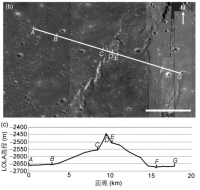
A propos Phil's far-from-"trivial prediction": there may be something in the way of that view of Promontorium Laplace. A fascinating paper (in Chinese, so I'm relying on the pictures) appeared last month in Scientia Sinica: "Geological features and magmatic activities history of Sinus Iridum". Scientia Sinica I believe it is fair use to post the LRO/LOLA-based elevation map for the wrinkle ridge near where most people now think Chang'e will land.
That will be some view, come tomorrow evening, if................ |
|
|
|
|
|
|
Dec 14 2013, 05:00 AM
Post
#30
|
|
 Senior Member Group: Admin Posts: 3108 Joined: 21-December 05 From: Canberra, Australia Member No.: 615 |
<ADMIN MODE>
From comments in a few recent posts, I just want to remind people to avoid making statements which may imply any political (and I mean that in its broadest sense) commentary about the merits or otherwise of the openness or otherwise of any particular nation's space program, government or media. As with ANY mission, what data/images are released are a bonus to the public (that includes UMSF'ers) not a right. </ADMIN MODE> Just enjoy the ride.
|
|
|
|
|
Dec 14 2013, 07:02 AM
Post
#31
|
|
|
Senior Member Group: Members Posts: 2428 Joined: 30-January 13 From: Penang, Malaysia. Member No.: 6853 |
Anyone aware of any plans to live stream any of the Chang'e landing process from its mission control center (similar to the launch)
|
|
|
|
|
Dec 14 2013, 07:04 AM
Post
#32
|
|
|
Member Group: Members Posts: 238 Joined: 28-October 12 Member No.: 6732 |
QUOTE (Cosmic Penguin @ Dec 13 2013, 08:54 PM) The best annotated diagram of the lander and rover I have seen so far...  The two features labeled as "fuel tanks" are actually "high-pressure gas cylinders" for pressurization of the pressure-fed propulsion system. |
|
|
|
|
Dec 14 2013, 07:05 AM
Post
#33
|
|
|
Senior Member Group: Members Posts: 2085 Joined: 13-February 10 From: Ontario Member No.: 5221 |
Any idea how low Earth will be in the sky to the cameras? Sinus Iridium is even farther from the sub-Earth point than Apollo 17 was, and I know it was lower in the sky from Taurus-Littrow than any of the other landing sites.
Also depends on how high the cameras can be pointed too! |
|
|
|
|
Dec 14 2013, 07:42 AM
Post
#34
|
|
|
Senior Member Group: Members Posts: 2920 Joined: 14-February 06 From: Very close to the Pyrénées Mountains (France) Member No.: 682 |
QUOTE (PaulH51 @ Dec 14 2013, 08:02 AM) Anyone aware of any plans to live stream any of the Chang'e landing process from its mission control center (similar to the launch) As usual, think of Emily's blog: http://www.planetary.org/blogs/emily-lakda...g-tomorrow.html-------------------- |
|
|
|
|
Dec 14 2013, 11:34 AM
Post
#35
|
|
|
Senior Member Group: Members Posts: 2428 Joined: 30-January 13 From: Penang, Malaysia. Member No.: 6853 |
QUOTE (climber @ Dec 14 2013, 03:42 PM) As usual, think of Emily's blog: http://www.planetary.org/blogs/emily-lakda...g-tomorrow.html Many thanks |
|
|
|
|
Dec 14 2013, 12:19 PM
Post
#36
|
|
|
Member Group: Members Posts: 550 Joined: 1-May 06 From: Scotland (Ecosse, Escocia) Member No.: 759 |
QUOTE (Explorer1 @ Dec 14 2013, 07:05 AM) Any idea how low Earth will be in the sky to the cameras? I estimate around 40 degrees above the horizon, based on the co-ordinates of the intended landing site. |
|
|
|
|
Dec 14 2013, 12:29 PM
Post
#37
|
|
|
Senior Member Group: Admin Posts: 3108 Joined: 21-December 05 From: Canberra, Australia Member No.: 615 |
|
|
|
|
|
Dec 14 2013, 12:55 PM
Post
#38
|
|
|
Merciless Robot Group: Admin Posts: 8783 Joined: 8-December 05 From: Los Angeles Member No.: 602 |
Thanks, Astro0! (Stayed up all night since Ms. Nprev wanted a night on the town. Turns out that she can't drink NEARLY as much as me, so she's beddy-bye. Me, I GOT to see this happen!)
-------------------- A few will take this knowledge and use this power of a dream realized as a force for change, an impetus for further discovery to make less ancient dreams real.
|
|
|
|
|
Dec 14 2013, 12:55 PM
Post
#39
|
|
 Senior Member Group: Members Posts: 1729 Joined: 3-August 06 From: 43° 35' 53" N 1° 26' 35" E Member No.: 1004 |
from the map they showed on CCTV it looks like CE3 is heading to the eastern edge of the landing site, and into Mare Imbrium, close to crater Le Verrier instead of Sinus Iridum
|
|
|
|
|
Dec 14 2013, 12:59 PM
Post
#40
|
||
|
Senior Member Group: Members Posts: 1729 Joined: 3-August 06 From: 43° 35' 53" N 1° 26' 35" E Member No.: 1004 |
Attached thumbnail(s)
|
|
|
|
|
|
|
Dec 14 2013, 01:01 PM
Post
#41
|
|||
|
Senior Member Group: Admin Posts: 3108 Joined: 21-December 05 From: Canberra, Australia Member No.: 615 |
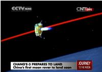
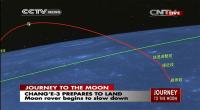
Chang'e 3 on final descent.
|
||
|
|
|
||
|
Dec 14 2013, 01:05 PM
Post
#42
|
|
|
Merciless Robot Group: Admin Posts: 8783 Joined: 8-December 05 From: Los Angeles Member No.: 602 |
Descent apparently proceeding well thus far. (Odd that there are also something like '7 minutes of terror' to do a lunar landing, just like a Mars landing...)
-------------------- A few will take this knowledge and use this power of a dream realized as a force for change, an impetus for further discovery to make less ancient dreams real.
|
|
|
|
|
Dec 14 2013, 01:08 PM
Post
#43
|
|
 Member Group: Members Posts: 655 Joined: 22-January 06 Member No.: 655 |
Heart in mouth time!
Good luck all! |
|
|
|
|
Dec 14 2013, 01:14 PM
Post
#44
|
|
 Senior Member Group: Members Posts: 1431 Joined: 26-July 08 Member No.: 4270 |
Touchdown! A spacecraft is now transmitting data from the surface of the Moon!
-------------------- -- Hungry4info (Sirius_Alpha)
|
|
|
|
|
Dec 14 2013, 01:14 PM
Post
#45
|
|
|
Senior Member Group: Admin Posts: 3108 Joined: 21-December 05 From: Canberra, Australia Member No.: 615 |
Touchdown!
|
|
|
|
|
Dec 14 2013, 01:15 PM
Post
#46
|
|
|
Junior Member Group: Members Posts: 62 Joined: 11-July 11 Member No.: 6058 |
A flawless landing as far as I can see. Well done all!
|
|
|
|
|
Dec 14 2013, 01:16 PM
Post
#47
|
|
|
Senior Member Group: Members Posts: 2428 Joined: 30-January 13 From: Penang, Malaysia. Member No.: 6853 |
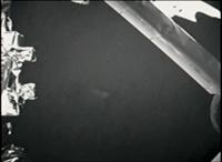
TD about 2 minutes ago......
Image of ground and part of a landing leg.... |
|
|
|
|
Dec 14 2013, 01:16 PM
Post
#48
|
|
|
Senior Member Group: Members Posts: 1729 Joined: 3-August 06 From: 43° 35' 53" N 1° 26' 35" E Member No.: 1004 |
the rabbit has landed
in Mare Imbrium instead of Sinus Iridum |
|
|
|
|
Dec 14 2013, 01:16 PM
Post
#49
|
|
|
Merciless Robot Group: Admin Posts: 8783 Joined: 8-December 05 From: Los Angeles Member No.: 602 |
That was SMOOTH, and had frame-by-frame descent imagery as well! Congratulations to the PRC!!!!!
-------------------- A few will take this knowledge and use this power of a dream realized as a force for change, an impetus for further discovery to make less ancient dreams real.
|
|
|
|
|
Dec 14 2013, 01:17 PM
Post
#50
|
||
|
Senior Member Group: Admin Posts: 3108 Joined: 21-December 05 From: Canberra, Australia Member No.: 615 |
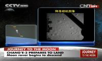
Images from the descent. Amazing. Too fast to get enough shots to animate.
Here's one frame at about 70 metres (?)
|
|
|
|
|
|
|
Dec 14 2013, 01:18 PM
Post
#51
|
|
|
Member Group: Members Posts: 149 Joined: 18-June 08 Member No.: 4216 |
And that, gentlemen, is how we do that..
|
|
|
|
|
Dec 14 2013, 01:19 PM
Post
#52
|
|
|
Member Group: Members Posts: 550 Joined: 1-May 06 From: Scotland (Ecosse, Escocia) Member No.: 759 |
From the big screen in Mission Control, it seems to have landed some way to east of Promontorium Laplace -- to be expected, given
it has landed one orbit earlier than the original discussions. |
|
|
|
|
Dec 14 2013, 01:20 PM
Post
#53
|
|
 Lord Of The Uranian Rings Group: Members Posts: 798 Joined: 18-July 05 From: Plymouth, UK Member No.: 437 |
-------------------- |
|
|
|
|
Dec 14 2013, 01:22 PM
Post
#54
|
|
|
Member Group: Members Posts: 149 Joined: 18-June 08 Member No.: 4216 |
Someone correct me if I am wrong, but I think their landing further east than sinus iridum may
have something yo do with the fact that they chose to land earlier (by 1.5 hr) and therefore the moon hadn't yet rotated sufficiently to align sinus iridum with the probe's trajectory. |
|
|
|
|
Dec 14 2013, 01:22 PM
Post
#55
|
|
|
Merciless Robot Group: Admin Posts: 8783 Joined: 8-December 05 From: Los Angeles Member No.: 602 |
Gotta say that I'm pretty impressed. Hope that the rest of the mission goes even half this well because that was apparently a faultless descent.
Wow. "We're BACK, baby!!!"
-------------------- A few will take this knowledge and use this power of a dream realized as a force for change, an impetus for further discovery to make less ancient dreams real.
|
|
|
|
|
Dec 14 2013, 01:23 PM
Post
#56
|
|
|
Senior Member Group: Members Posts: 2085 Joined: 13-February 10 From: Ontario Member No.: 5221 |
Woke up too late, thanks for the gif!
First surface images coming soon? |
|
|
|
|
Dec 14 2013, 01:29 PM
Post
#57
|
|
|
Member Group: Members Posts: 149 Joined: 18-June 08 Member No.: 4216 |
Correction on previous: it's 3.5 hours earlier. The Moon would have (not) rotated an extra ~2 deg or 60 km.
|
|
|
|
|
Dec 14 2013, 01:32 PM
Post
#58
|
||
|
Senior Member Group: Admin Posts: 3108 Joined: 21-December 05 From: Canberra, Australia Member No.: 615 |
Last frame from descent camera.
|
|
|
|
|
|
|
Dec 14 2013, 01:47 PM
Post
#59
|
|
|
Member Group: Members Posts: 149 Joined: 18-June 08 Member No.: 4216 |
From the images taken from CCTV's live footage posted at the NASASpaceflight forum, it looks like it landed
near crater Laplace F, south of Montes Rectii. |
|
|
|
|
Dec 14 2013, 01:47 PM
Post
#60
|
|
|
Senior Member Group: Members Posts: 1729 Joined: 3-August 06 From: 43° 35' 53" N 1° 26' 35" E Member No.: 1004 |
59 pictures were sent back in real time
|
|
|
|
|
Dec 14 2013, 01:51 PM
Post
#61
|
|
|
Senior Member Group: Members Posts: 1729 Joined: 3-August 06 From: 43° 35' 53" N 1° 26' 35" E Member No.: 1004 |
QUOTE (tolis @ Dec 14 2013, 02:47 PM) it looks like it landed near crater Laplace F, south of Montes Rectii. seems to be in a flat area of Mare Imbrium between Laplace F and le Verrier |
|
|
|
|
Dec 14 2013, 01:59 PM
Post
#62
|
|
|
Senior Member Group: Members Posts: 2085 Joined: 13-February 10 From: Ontario Member No.: 5221 |
Live coverage over for now. Replaying landing....
|
|
|
|
|
Dec 14 2013, 02:00 PM
Post
#63
|
|
|
Junior Member Group: Members Posts: 64 Joined: 15-June 12 From: Hong Kong Member No.: 6419 |
The landing site is at 19.51 deg. West, 44.12 deg. North, per reports from the control center.
-------------------- UMSF - the place of Opportunity to satisfy your Spirit of Curiosity via Perseverance
|
|
|
|
|
Dec 14 2013, 02:06 PM
Post
#64
|
|
|
Senior Member Group: Members Posts: 1729 Joined: 3-August 06 From: 43° 35' 53" N 1° 26' 35" E Member No.: 1004 |
thank you. that is 20-30 km southeast of Laplace F
|
|
|
|
|
Dec 14 2013, 02:29 PM
Post
#65
|
|
|
Member Group: Members Posts: 550 Joined: 1-May 06 From: Scotland (Ecosse, Escocia) Member No.: 759 |
Xinhua news agency has announced erroneously that Chang'e-3 landed on the moon's Sinus Iridum, or the Bay of Rainbows, at about 9:12 p.m. Saturday,
making China the third country in the world to carry out such a rover mission after the United States and former Soviet Union. This is wrong location as the Mission Control panel screen showed it landing well to the east of Sinus Iridium, in Mare Imbrium. My estimate of the landing coordinates, from the low-res screen, is in the area of 19 degrees West, 45 degrees North. That would put it about 25km SE of the ~7km diameter crater Laplace F, near a ridge or scarp, and a couple of other craters of 2km diameter. So there might be some topography in view. (written before previous announcements!) |
|
|
|
|
Dec 14 2013, 02:32 PM
Post
#66
|
|
|
Senior Member Group: Members Posts: 1729 Joined: 3-August 06 From: 43° 35' 53" N 1° 26' 35" E Member No.: 1004 |
where is Phill Stooke when we need him!
|
|
|
|
|
Dec 14 2013, 02:37 PM
Post
#67
|
||
 Senior Member Group: Members Posts: 2492 Joined: 15-January 05 From: center Italy Member No.: 150 |
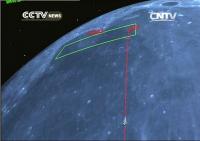
Looking to the following CNTV screenshot, it seems that actual landing point is the rightmost one in the green box, presumably showing the previously selected potential landing area...
Attached thumbnail(s)
-------------------- I always think before posting! - Marco -
|
|
|
|
|
|
|
Dec 14 2013, 03:08 PM
Post
#68
|
||
|
Junior Member Group: Members Posts: 64 Joined: 15-June 12 From: Hong Kong Member No.: 6419 |
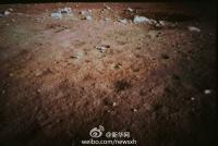
And the first image from the lander's monitoring camera.
(Source: Xinhua News Agency)
Attached thumbnail(s)
-------------------- UMSF - the place of Opportunity to satisfy your Spirit of Curiosity via Perseverance
|
|
|
|
|
|
|
Dec 14 2013, 03:38 PM
Post
#69
|
|
 Senior Member Group: Admin Posts: 4763 Joined: 15-March 05 From: Glendale, AZ Member No.: 197 |
QUOTE (Astro0 @ Dec 14 2013, 05:32 AM) Last frame from descent camera. I don't suppose they named the descent camera 星期二 (Xīng qī èr)... -------------------- If Occam had heard my theory, things would be very different now.
|
|
|
|
|
Dec 14 2013, 03:41 PM
Post
#70
|
|
 Senior Member Group: Moderator Posts: 3233 Joined: 11-February 04 From: Tucson, AZ Member No.: 23 |
Any chance the landing site is in an existing LROC frame?
-------------------- &@^^!% Jim! I'm a geologist, not a physicist!
The Gish Bar Times - A Blog all about Jupiter's Moon Io |
|
|
|
|
Dec 14 2013, 04:01 PM
Post
#71
|
|
|
Solar System Cartographer Group: Members Posts: 10162 Joined: 5-April 05 From: Canada Member No.: 227 |
Very good chance, the whole area is blanketed with images, and Chinese scientists downloaded them all in that area (confirmed by LROC team) and will have chosen a site which is well imaged.
Phil -------------------- ... because the Solar System ain't gonna map itself.
Also to be found posting similar content on https://mastodon.social/@PhilStooke Maps for download (free PD: https://upload.wikimedia.org/wikipedia/comm...Cartography.pdf NOTE: everything created by me which I post on UMSF is considered to be in the public domain (NOT CC, public domain) |
|
|
|
|
Dec 14 2013, 04:03 PM
Post
#72
|
|
|
Solar System Cartographer Group: Members Posts: 10162 Joined: 5-April 05 From: Canada Member No.: 227 |
"where is Phill Stooke when we need him!"
Good day for the home internet to go down! Also real life is getting in the way, but I should be back in my protective bubble soon. Phil -------------------- ... because the Solar System ain't gonna map itself.
Also to be found posting similar content on https://mastodon.social/@PhilStooke Maps for download (free PD: https://upload.wikimedia.org/wikipedia/comm...Cartography.pdf NOTE: everything created by me which I post on UMSF is considered to be in the public domain (NOT CC, public domain) |
|
|
|
|
Dec 14 2013, 04:42 PM
Post
#73
|
|
|
Member Group: Members Posts: 378 Joined: 21-April 05 From: Portugal Member No.: 347 |
 I break my long hibernation from this group  to post a quick mosaic of some of the descent camera frames. to post a quick mosaic of some of the descent camera frames. I corrected the proportions to have square craters. There are some more distant frames that could cover a larger area. -------------------- _______________________
www.astrosurf.com/nunes |
|
|
|
|
Dec 14 2013, 05:29 PM
Post
#74
|
|||
|
Senior Member Group: Members Posts: 1431 Joined: 26-July 08 Member No.: 4270 |
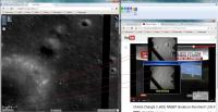
Well, I've identified the landing site.
Lat: ~44.1260, Lon: ~-19.5014. Using http://target.lroc.asu.edu/q3/ and matching it to several of the descent camera images. See below.
Attached thumbnail(s)
-------------------- -- Hungry4info (Sirius_Alpha)
|
||
|
|
|
||
|
Dec 14 2013, 05:38 PM
Post
#75
|
|
|
Senior Member Group: Members Posts: 2517 Joined: 13-September 05 Member No.: 497 |
QUOTE (Hungry4info @ Dec 14 2013, 10:29 AM) Well, I've identified the landing site. Wow, nice work. Seems convincing to me. -------------------- Disclaimer: This post is based on public information only. Any opinions are my own.
|
|
|
|
|
Dec 14 2013, 05:49 PM
Post
#76
|
|
|
Senior Member Group: Members Posts: 1729 Joined: 3-August 06 From: 43° 35' 53" N 1° 26' 35" E Member No.: 1004 |
great work! so could the blocky crater we are seeing during the descent be the same one visible on that first surface pic?
|
|
|
|
|
Dec 14 2013, 05:57 PM
Post
#77
|
|
|
Senior Member Group: Members Posts: 1431 Joined: 26-July 08 Member No.: 4270 |
I think the crater from the surface image is actually a smaller one nearer the landing site. You can see it (and boulders in it that correspond fairly well to the surface image) in like the last frame before landing.
Edit: After looking at it again, I'm less certain of this. -------------------- -- Hungry4info (Sirius_Alpha)
|
|
|
|
|
Dec 14 2013, 06:10 PM
Post
#78
|
||
|
Member Group: Members Posts: 550 Joined: 1-May 06 From: Scotland (Ecosse, Escocia) Member No.: 759 |
This is the wider picture of the landing site, from Xinhua News Agency.
The crater which is 3 flag heights above the landing site is Laplace F. The largest crater in the cluster to the west of the landing site is Laplace FA (at least, it is on my rather old Apollo-era US map).
|
|
|
|
|
|
|
Dec 14 2013, 06:16 PM
Post
#79
|
||
|
Senior Member Group: Members Posts: 1431 Joined: 26-July 08 Member No.: 4270 |
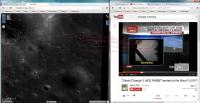
Candidate surface feature identifications.
Attached thumbnail(s)
-------------------- -- Hungry4info (Sirius_Alpha)
|
|
|
|
|
|
|
Dec 14 2013, 06:30 PM
Post
#80
|
|
 Member Group: Members Posts: 290 Joined: 29-December 05 From: Ottawa, ON Member No.: 624 |
QUOTE (Hungry4info @ Dec 14 2013, 11:16 AM) Candidate surface feature identifications. Hello Old Friend, Long time no see! |
|
|
|
|
Dec 14 2013, 06:44 PM
Post
#81
|
|
|
Senior Member Group: Members Posts: 2085 Joined: 13-February 10 From: Ontario Member No.: 5221 |
Looking at the video on Emily's blog post, that very first image after landing is a little blurry in the shadows; that must've been the dust not quite settled. They sharpen in the next one:
https://www.youtube.com/watch?v=xfNb0jeTi2s From 12:00 to 12:33 you can see it soften! Not quite Curiosity style, but still really impressive (and presumably more images will come down soon)! |
|
|
|
|
Dec 14 2013, 06:48 PM
Post
#82
|
|
|
Member Group: Members Posts: 149 Joined: 18-June 08 Member No.: 4216 |
If the landing site ID posted by Hungry4info is correct,
the rover should find itself in a target-rich environment. There are rocks and boulders of various sizes, especially along the rim of "the" large crater immediately to the west of the lander. On the near side of that rim there is also a bright patch that may be ejecta from a small, fresh crater. I wonder if the peaks of Montes Rectii are jutting above the N horizon Pole-Position style, ~100 km away. That would be fun. PS. The Pole-Position reference will only make sense to the more seasoned among you.. |
|
|
|
|
Dec 14 2013, 06:51 PM
Post
#83
|
|
|
Member Group: Members Posts: 123 Joined: 3-September 12 From: Almeria, SE Spain Member No.: 6632 |
QUOTE (Hungry4info @ Dec 14 2013, 07:16 PM) Candidate surface feature identifications. Interesting. If you turn upside down (180deg) the picture at right (before landing), and correct your assignment of "D", then it looks very convincing. What size has this crater? Thorsten |
|
|
|
|
Dec 14 2013, 06:58 PM
Post
#84
|
|
|
Senior Member Group: Members Posts: 1431 Joined: 26-July 08 Member No.: 4270 |
The crater is 20 metres across and about 20 metres from the lander. And yeah, my D is off. Thanks for the correction.
-------------------- -- Hungry4info (Sirius_Alpha)
|
|
|
|
|
Dec 14 2013, 08:29 PM
Post
#85
|
|
|
Member Group: Members Posts: 123 Joined: 3-September 12 From: Almeria, SE Spain Member No.: 6632 |
My "interpretation" of your findings.
Easier to see the coincidence. 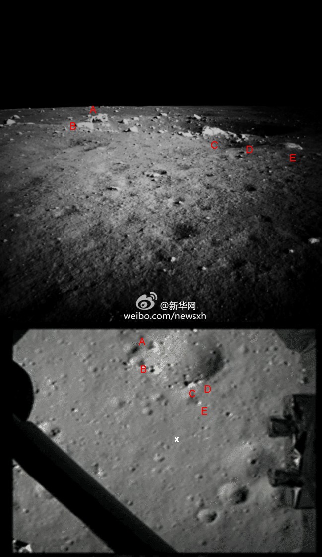 Thorsten PD: North is up. |
|
|
|
|
Dec 14 2013, 08:47 PM
Post
#86
|
|
|
Senior Member Group: Members Posts: 1431 Joined: 26-July 08 Member No.: 4270 |
Nice work. That does make it easier to see!
-------------------- -- Hungry4info (Sirius_Alpha)
|
|
|
|
|
Dec 14 2013, 09:02 PM
Post
#87
|
|
|
Merciless Robot Group: Admin Posts: 8783 Joined: 8-December 05 From: Los Angeles Member No.: 602 |
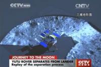
Live feed from CCTV just started; rover roll-off to occur shortly.
http://english.cntv.cn/live/p2p/index.shtml UPDATE: CCTV reports Yutu rover on the surface! No imagery yet. -------------------- A few will take this knowledge and use this power of a dream realized as a force for change, an impetus for further discovery to make less ancient dreams real.
|
|
|
|
|
Dec 14 2013, 09:11 PM
Post
#88
|
|
|
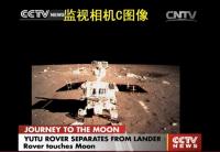
Senior Member Group: Members Posts: 2085 Joined: 13-February 10 From: Ontario Member No.: 5221 |
Ramps being shown; rover shadow on left!
It's driving onto the ramp! Crane lowering! Surface in background! |
|
|
|
|
Dec 14 2013, 09:17 PM
Post
#89
|
||
|
Senior Member Group: Admin Posts: 3108 Joined: 21-December 05 From: Canberra, Australia Member No.: 615 |
Yutu on the ramp being lowered to surface.
|
|
|
|
|
|
|
Dec 14 2013, 09:19 PM
Post
#90
|
|
|
Senior Member Group: Members Posts: 2085 Joined: 13-February 10 From: Ontario Member No.: 5221 |
Six wheels on Moon! Tracks!
|
|
|
|
|
Dec 14 2013, 09:20 PM
Post
#91
|
||
|
Senior Member Group: Admin Posts: 3108 Joined: 21-December 05 From: Canberra, Australia Member No.: 615 |
|
|
|
|
|
|
|
Dec 14 2013, 09:24 PM
Post
#92
|
|
|
Merciless Robot Group: Admin Posts: 8783 Joined: 8-December 05 From: Los Angeles Member No.: 602 |
I watched the deployment (previously recorded). VERY interesting deployment method. Looked like it rolled forward onto the top of the ramp, which itself was subsequently lowered to contact the surface for roll-off. Don't we've seen a schema like that before.
-------------------- A few will take this knowledge and use this power of a dream realized as a force for change, an impetus for further discovery to make less ancient dreams real.
|
|
|
|
|
Dec 14 2013, 09:26 PM
Post
#93
|
|
|
Member Group: Members Posts: 154 Joined: 21-April 05 From: Rochester, New York, USA Member No.: 336 |
Great coverage. HD res update every second.
|
|
|
|
|
Dec 14 2013, 09:27 PM
Post
#94
|
||
|
Senior Member Group: Members Posts: 1431 Joined: 26-July 08 Member No.: 4270 |
They showed the lander's area, presumably as imaged by the monitoring camera.
Attached thumbnail(s)
-------------------- -- Hungry4info (Sirius_Alpha)
|
|
|
|
|
|
|
Dec 14 2013, 09:33 PM
Post
#95
|
|
|
Senior Member Group: Admin Posts: 3108 Joined: 21-December 05 From: Canberra, Australia Member No.: 615 |
Emily just posted an animation of Yutu driving onto the surface. As she says "Woohoo!".
http://www.planetary.org/blogs/emily-lakda...l-for-yutu.html |
|
|
|
|
Dec 14 2013, 09:56 PM
Post
#96
|
|
|
Senior Member Group: Members Posts: 1729 Joined: 3-August 06 From: 43° 35' 53" N 1° 26' 35" E Member No.: 1004 |
my friend Tezio from the French "forum de la conquete spatiale" has authorized me to re-post here his amazing analysis of the landing trajectory of CE-3.
He assembled all the available images and took the center of each one, assuming the camera to be looking at the local vertical. The probe had no rotation at all. Only near the surface, it backed up and moved a bit to the right before touching down.  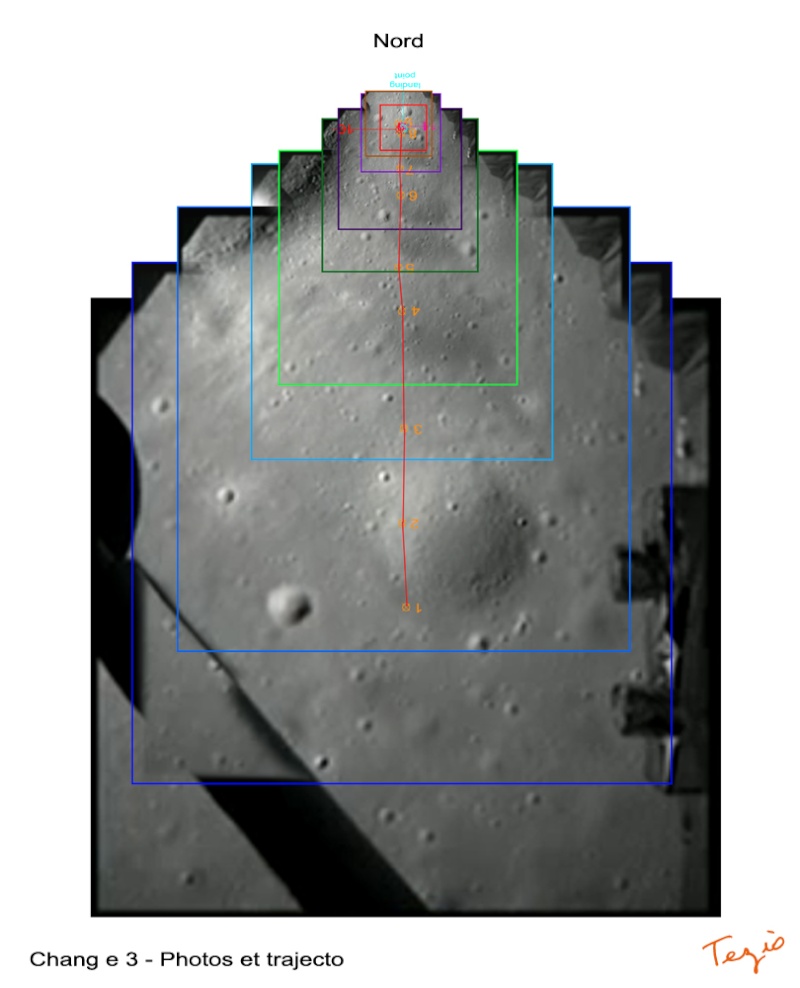 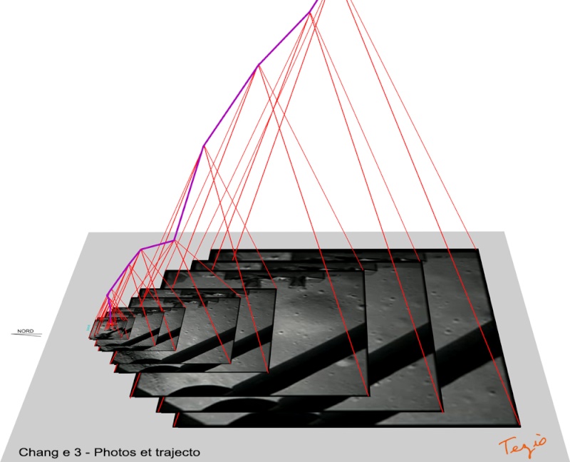  |
|
|
|
|
Dec 14 2013, 10:18 PM
Post
#97
|
|
|
Member Group: Members Posts: 550 Joined: 1-May 06 From: Scotland (Ecosse, Escocia) Member No.: 759 |
Wonderful piece of work.... It looks like the edge of large crater just a few tens of metres to the west of the landing site.
|
|
|
|
|
Dec 14 2013, 10:20 PM
Post
#98
|
|
|
Member Group: Members Posts: 105 Joined: 27-August 05 Member No.: 479 |
shadow on the left so rover is facing south? |
|
|
|
|
Dec 14 2013, 10:24 PM
Post
#99
|
|
|
Member Group: Members Posts: 550 Joined: 1-May 06 From: Scotland (Ecosse, Escocia) Member No.: 759 |
No, Rover drove off in the direction of north. Sun on right (east), and shadows on left (west) side.
|
|
|
|
|
Dec 14 2013, 10:25 PM
Post
#100
|
|
|
Solar System Cartographer Group: Members Posts: 10162 Joined: 5-April 05 From: Canada Member No.: 227 |
No, facing north. It's morning, the sun is in the east, the shadow points west.
Phil -------------------- ... because the Solar System ain't gonna map itself.
Also to be found posting similar content on https://mastodon.social/@PhilStooke Maps for download (free PD: https://upload.wikimedia.org/wikipedia/comm...Cartography.pdf NOTE: everything created by me which I post on UMSF is considered to be in the public domain (NOT CC, public domain) |
|
|
|
|

|
Lo-Fi Version | Time is now: 16th May 2024 - 12:46 AM |
|
RULES AND GUIDELINES Please read the Forum Rules and Guidelines before posting. IMAGE COPYRIGHT |
OPINIONS AND MODERATION Opinions expressed on UnmannedSpaceflight.com are those of the individual posters and do not necessarily reflect the opinions of UnmannedSpaceflight.com or The Planetary Society. The all-volunteer UnmannedSpaceflight.com moderation team is wholly independent of The Planetary Society. The Planetary Society has no influence over decisions made by the UnmannedSpaceflight.com moderators. |
SUPPORT THE FORUM Unmannedspaceflight.com is funded by the Planetary Society. Please consider supporting our work and many other projects by donating to the Society or becoming a member. |
|