Printable Version of Topic
Click here to view this topic in its original format
Unmanned Spaceflight.com _ Opportunity _ The Start of the Drive East
Posted by: fredk Jun 1 2010, 04:36 PM
I think there are a number of reasons to start a new thread. Squyres has confirmed we have turned east. We've passed the solstice and sunlight is now improving. Also we should be past the worst of the dunes now.
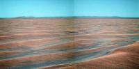
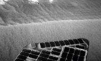
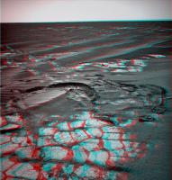
And, we've finally gotten new pics down!  And for the first time I can recall, the jpl site has beaten exploratorium! Here are the lookbacks after the 2252 and 2254 drives:
http://marsrovers.jpl.nasa.gov/gallery/all/1/n/2252/1N328192785EFFAHKCP1795R0M1.JPG
http://marsrovers.jpl.nasa.gov/gallery/all/1/n/2254/1N328371566EFFAHNDP1777R0M1.JPG
For those who don't know, the jpl site is one sol out of synch. You should add one sol to those numbers (2252 and 2254) to get the actual sols.
There was a new drive on sol 2256:
http://marsrovers.jpl.nasa.gov/gallery/all/1/f/2255/1F328471044EFFAHQ8P1212R0M1.JPG
Posted by: Phil Stooke Jun 1 2010, 05:07 PM
Thanks, Fred!
Phil
Posted by: MarkG Jun 1 2010, 05:13 PM
In regards to the discussion in the previous thread concerning the "geo"morphology of the benches around the Endeavour crater rim hills, this is one case where many possible explanations will be resolved [maybe] by the ground-truth of rover examination.
My personal working idea is that there were periods characterized by seasonal ice cover, which would be sometimes mobilized by bottom-ice-surface melting/brine-ing, which led to the ramp erosion seen in Victoria. On a larger scale, that could lead to some features seen on the Endeavour rim, which have some glacial-looking aspects (thinner ice, in the scenario I'm thinking of). They could be evaporite or wave benches, too, but the situation remains murky (and mostly below freezing, too).
We will also be descending from the rise we have been traveling on into darker-looking stuff, which may be the darker sediments seen a few feet down the the craters examined. One wonders if the pavement will be quantitatively different there.
Looking forward to the unknown...
Posted by: Tesheiner Jun 1 2010, 06:32 PM

http://marsrovers.jpl.nasa.gov/gallery/all/1/f/2255/1F328471044EFFAHQ8P1212R0M1.JPG
I'm waiting for the navcam mosaic from this same site to update the map... Meanwhile, say that based on the ripples' direction that was a SE drive, at least on it's latest portion.
Posted by: Astro0 Jun 2 2010, 02:18 AM
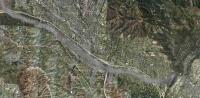
Phil's 1km annotated map on the 'distant vistas' thread and Tesh's route map, make for a nice combined view of the rest of Opportunity's journey to the East (east-south-east-ish).

|
So close and yet, still so far away. Go Oppy!
Posted by: nprev Jun 2 2010, 02:22 AM
 ...beautiful, yet sobering!
Posted by: DFinfrock Jun 2 2010, 02:39 AM
We now know the naming convention to be used on Endeavour:
Let's put Botany Bay in reserve... until such time as Oppy actually discovers Martian botany.

Posted by: walfy Jun 3 2010, 04:40 AM
A few maps on Oppy's present distance from "landfall," using references closer to home. Present location of rover is roughly in the upper-right corner. I used Phil's 1 km annotated map, the grid of which is partially visible on the path. This will be one historic push. Go Oppy!
|
|
|
|
Here's reference familiar to some...!
|
Posted by: nprev Jun 3 2010, 05:19 AM
Hey, really useful context, Walfy, thanks! 
Posted by: Stu Jun 3 2010, 05:44 AM
You, Sir, are a genius! Thanks for those, really useful. I might have a couple of requests for you later...

Posted by: nprev Jun 3 2010, 05:50 AM
Thought somehow you might, Stu. This is a brilliant idea for outreach!
Posted by: Stu Jun 3 2010, 05:55 AM
This is a brilliant idea for outreach!...and a brilliant and perfect addition to our August 14th http://ksssm2.wordpress.com...!

Posted by: Explorer1 Jun 3 2010, 08:09 AM
I can't recognize that last one walfy; where is that?
Still a good idea, as long as they have a label!
Posted by: walfy Jun 3 2010, 08:23 AM
[quote name='walfy' date='Jun 2 2010, 08:40 PM' post='160468']
A few maps on Oppy's present distance from "landfall," using references closer to home. Present location of rover is roughly in the upper-right corner. I used Phil's 1 km annotated map, the grid of which is partially visible on the path. This will be one historic push. Go Oppy!
Oops! I should have written "upper-left corner" for the present location of the rover on those reference maps. The last mystery location is Oppy's birthplace at least where she was assembled, and where the drivers do their driving, I'm assuming, could be wrong. Namely, JPL.
Posted by: Explorer1 Jun 3 2010, 08:25 AM
Yes, I had the feeling it would be JPL, thanks for confirming it!
Keep on trucking Oppy...
Posted by: Oersted Jun 4 2010, 12:07 PM
Walfy, thx for those pictures, it is a very good idea, previously used to show the scale of the various craters we have visited.
And as to the new heading.... "Go East, old woman!"
- Mars IS different
Posted by: elakdawalla Jun 4 2010, 08:40 PM
All posts dealing with the possible problem that showed up with the PMA actuator on sol 2257 have been split to a http://www.unmannedspaceflight.com/index.php?showtopic=6629. Let's keep this one for the driving!
Posted by: HughFromAlice Jun 6 2010, 01:31 PM
Navs from 2255 - bit hard to get even brightness/decent colour etc. But good to have a bit of spare time, have fun on my new Dell M6500 laptop + try out Corel5 Photopaint + start posting again ! Might get round to posting full size image on Flikr.
See reposted pic as just below................
Posted by: ngunn Jun 6 2010, 02:43 PM
Nice, but I think that 'new' mountain on the left is an art-effect. Looking at the raw you used I can just about see where it came from. Here's the view from the other camera though, and there's no sign of it:
http://marsrovers.jpl.nasa.gov/gallery/all/1/n/2254/1N328371320EFFAHNDP1777R0M2.HTML
Posted by: HughFromAlice Jun 6 2010, 09:16 PM
Oh no! I thought that I had discovered a new mountain and was going to ask it be named Mount Alice after my home town!!!! I have digitally blasted it off the face of Mars and reposted a v2 without artifact


|
Posted by: briv1016 Jun 12 2010, 05:48 AM
2270 looks like a driving sol.
Posted by: Tesheiner Jun 12 2010, 07:49 AM
Yup, and including an east pointing navcam mosaic at end-of-drive.
Posted by: Tesheiner Jun 13 2010, 06:22 PM
Tosol's drive has already finished and there's already some data at the tracking web telling that 70m were covered in an almost due east heading.
Besides, the pointing info associated to the "post-drive" navcam mosaic tells the PMA is behaving well.
All good space news today.
Posted by: Tesheiner Jun 14 2010, 06:26 PM
A few thumbnails from yestersol's drive.
Navcam: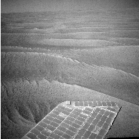
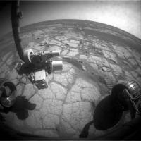
FHazcam: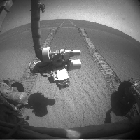
Posted by: BrianL Jun 14 2010, 11:35 PM
I'm a bit surprised at how ripple-y it still looks, believe it or not. (Sorry)
Posted by: kenny Jun 14 2010, 11:57 PM
The maps shows it's just a short section of low dunes, then we're on linked pavements....
Posted by: lyford Jun 15 2010, 02:36 AM
Thank you for keeping alive the punmanned spaceflight legacy!
Posted by: nprev Jun 15 2010, 02:46 AM
Painful.
Posted by: fredk Jun 15 2010, 09:30 PM
New pics are finally at the jpl site. It's nice having Endeavour in our drive-direction sights:
http://marsrovers.jpl.nasa.gov/gallery/all/1/p/2271/1P329792599EFFAIFVP2446R1M1.JPG
Posted by: elakdawalla Jun 15 2010, 09:34 PM
Endeavour in the drive-direction sights...now THAT will make for an especially awesome approach movie!
Posted by: Stu Jun 15 2010, 09:36 PM
Thank **** for that; I've been having serious withdrawl symptoms...
Posted by: BrianL Jun 16 2010, 03:21 AM
Haven't we all. Exploratorium: it's a good thing. Cobbles ahead, but we'll have to approach slowly. Mars has put up speed bumps.
Aah, so good to be moving again, seeing pictures again. I am so addicted to MERs. Makes me wonder what I'll do when... if... no, I won't go there.
Posted by: Poolio Jun 16 2010, 03:21 AM
Tim Parker's latest http://marsrovers.jpl.nasa.gov/mission/tm-opportunity/opportunity-sol2272.html shows that another 70m or so was achieved heading due east on sol 2272.
Posted by: Tesheiner Jun 16 2010, 06:07 AM
Oh, I missed that drive. I'll update mine later on.
Posted by: MahFL Jun 16 2010, 12:14 PM
Is Oppy going slightly uphill ?
Posted by: fredk Jun 16 2010, 02:29 PM
Why do you ask? We should be going very slightly downhill now since we crested the ridge a while back.
Posted by: Ant103 Jun 16 2010, 02:42 PM
Sol 2271 drive direction in color
http://www.db-prods.net/marsroversimages/Opportunity/2010/Sol2271-pancam.jpg
... showing unusal details on the hill of the right
Posted by: ElkGroveDan Jun 16 2010, 03:19 PM
Ant's panorama shows the high crater on the SE slope of Endeavor that I've been watching for. It's also an indication of just how clear the skies must be. That crater is about 32 km away!
(the scale is probably off a bit in this comparison)
|
Posted by: Drkskywxlt Jun 16 2010, 03:31 PM
(the scale is probably off a bit in this comparison)
Is that the circular feature on the tall hill on the right side of the panorama? Do you know that's a crater from the orbital imagery?
Posted by: ElkGroveDan Jun 16 2010, 03:38 PM
Yes and yes.
Posted by: HughFromAlice Jun 16 2010, 03:56 PM
Quick stitch and colour of Nav Cams from Sol 2270 - stayed up a bit later than I meant!!! Doing this is too absorbing!
Probably worth doing a better job on it so I may repost if I get the time - work is very busy.
Anyway hope it gives you guys some enjoyment.

|
Posted by: Ant103 Jun 17 2010, 03:11 PM
Sol 2272
http://www.db-prods.net/marsroversimages/Opportunity/2010/Sol2272-pano.jpg
Posted by: Steve Holtam Jun 17 2010, 06:06 PM
Awesome image Ant! Looks like smooth roving to me. Go Oppy!
Posted by: Tesheiner Jun 17 2010, 09:00 PM
Actually, that site is right now (late sol 2274) 60m to the west.

Posted by: Robert S Jun 18 2010, 07:54 AM
More driving from what I can read on http://marsrovers.nasa.gov/mission/status.html#opportunity.
Go oppy! =)
Posted by: Tesheiner Jun 18 2010, 05:23 PM
Actually, it's several sols in the past.
The latest info on this subject has been tweeted by Scott Maxwell: Yesterday's uplink did not make it onboard. We're not sure why it happened this time, but it does happen. Today: repeat yesterday's drive. AFAIK, it means no drive on sol 2275 (i.e. right now) but on sol 2276.
Posted by: Ant103 Jun 18 2010, 09:33 PM
Sol 2272
http://www.db-prods.net/marsroversimages/Opportunity/2010/Sol2272-pancam.jpg
Still have a very good transparency .
Posted by: Ant103 Jun 21 2010, 02:46 PM
Sol 2274 navcam. The sky is to be particulary in a good transparency.
http://www.db-prods.net/marsroversimages/Opportunity/2010/Sol2274-pano.jpg
Posted by: Tman Jun 22 2010, 08:45 AM
Yes, fine weather currently, also the shadows are so dark.
On the MER website we've got now a nice east corridor http://marsrovers.jpl.nasa.gov/mission/tm-opportunity/index.html
Posted by: fredk Jun 22 2010, 09:15 PM
The latest images include multispectral pancams of this area:
http://marsrovers.jpl.nasa.gov/gallery/all/1/p/2278/1P330415376ESFAJ00P2555R1M1.JPG
Potential meteorite, roughly centred, one quarter down from top of frame?
Posted by: Tesheiner Jun 23 2010, 09:37 AM
We'll see. It's roughly located SE of that position and the last move, during sol 2279, was more or less in that same direction.
BTW, I *think* this pancam sequence was automatically triggered by the new AEGIS software.
Posted by: ngunn Jun 23 2010, 01:22 PM
Regarding the change of direction I note that prior to the move we had just rejoined the proposed route line and the latest move tracks that line very closely. I wonder how closely we will be following it from here onward?
Posted by: Phil Stooke Jun 23 2010, 01:37 PM
Don't put too much store in the 'proposed route', it only denotes the general direction. The actual route will have to zigzag between small obstacles like larger than average drifts and (later) Anatolia-style troughs, with occasional sidesteps to look at items of interest.
Phil
Posted by: Tesheiner Jun 23 2010, 09:09 PM
The images taken during sol 2279 are already available on the JPL site.
Curiously, the navcams (http://marsrovers.jpl.nasa.gov/gallery/all/opportunity_n2279.html) are tilted *up* 19 deg. instead of the usual 17 deg. down. It reminds me of that drive which was planned for X meters in one direction but was actually commanded on the opposite way.
Posted by: fredk Jun 23 2010, 11:52 PM
Those navcams are odd. I wondered about cloud imaging - on the same sol there was a cloud in the fhazcam:
http://marsrovers.jpl.nasa.gov/gallery/all/1/f/2279/1F330506992EFFAJFAP1205R0M1.JPG
But cloud navcams are usually a series of downsampled frames.
Maybe they're looking at sky transparency - those navcams show nicely how much the sky darkens as you move up from the horizon. To eliminate the effects of vignetting, which is symmetric about the frame centre, compare the brightness of sky the same distance from the top and bottom of the frame.
Edit - of course these jpegs are auto stretched, so they don't reflect how much the sky really darkens with height.
Posted by: Ant103 Jun 24 2010, 12:22 AM
The pano. Personnaly, I like this kind of view .
http://www.db-prods.net/marsroversimages/Opportunity/2010/Sol2279-pano.jpg
Posted by: Stu Jun 24 2010, 05:16 AM
.I know exactly what you mean. Wide open spaces... can't beat 'em...
Posted by: ElkGroveDan Jun 24 2010, 05:36 AM
I've been gazing at Ant's http://www.unmannedspaceflight.com/index.php?showtopic=6438&view=findpost&p=161362 from a couple of days ago on my second monitor. It looks so clear and those hills so tantalizing that if I were standing there in person I'd swear the hills were only two or three miles away (instead of the 20 mile distance that the far rim is sitting at.) You almost want to break into a run.
Posted by: Bill Harris Jun 24 2010, 04:56 PM
Didn't we have a discussion in "Distant Vistas" about being able to see hills clearly from long distances (20-90 miles), even here on Earth? I'm thinking mid-March of this year.
--Bill
Posted by: Ant103 Jun 24 2010, 05:13 PM
Can't resist more
Color based on my last desktop pic.
http://www.db-prods.net/marsroversimages/Opportunity/2010/Sol2279-pano-recti-colorized.jpg
Posted by: marsophile Jun 24 2010, 08:37 PM
|
There are two areas just up ahead where the ripples appear to be "erased" or filled in. What could cause this? Localized piles of dust?
Posted by: Tesheiner Jun 24 2010, 08:49 PM
I think it's possible to see the nearest field to the SE in the pancams from sol 2279.
http://marsrovers.jpl.nasa.gov/gallery/all/1/p/2279/1P330507266EFFAJFDP2352R2M1.JPG and http://marsrovers.jpl.nasa.gov/gallery/all/1/p/2279/1P330507336EFFAJFDP2352R2M1.JPG
Posted by: fredk Jun 25 2010, 03:50 PM
From the http://marsrovers.jpl.nasa.gov/mission/status_opportunityAll.html#sol2273 improvements in a couple of numbers:

Posted by: marsophile Jun 25 2010, 03:51 PM
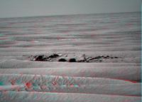
This might be part of the area where the ripples are muted in the orbital image. Lots of small pebbles here.
http://marsrovers.nasa.gov/gallery/all/1/p/2281/1P330683264EFFAJJ1P2558L7M1.JPG
Posted by: Phil Stooke Jun 25 2010, 04:36 PM
Like the ripples outside of Eagle crater! Lovely. More of that terrain to come in a few more kilometers!
Phil
Posted by: Ant103 Jun 25 2010, 05:12 PM
In colors http://www.db-prods.net/marsroversimages/Opportunity/2010/1P330683201EFFAJJ1P2558LCoul.jpg
Yes, this is great to have terrain like that .
Posted by: Stu Jun 26 2010, 07:31 AM
Been a while since I made a 3D view, so here goes... some lovely ripples here, dontcha think?
|
Views like that, and Dan's recent comments about the amazing success of the rovers, set me thinking about the ultimate fate of the Mars rovers. Warning: the following link takes you to a blog post that might - ok, will definitely - offend non rover-huggers, so if that's you, save yourself a lot of teeth-gnashing, and don't click on it, ok? You'll just get all antsy, post a snide comment, which I'll then reply to equally snidely, and before you know it there's a great big crack in the universe and Silence is Falling, so just move on, nothing to see here for you...
http://roadtoendeavour.wordpress.com/2010/06/25/looking-to-the-future
Posted by: ElkGroveDan Jun 26 2010, 07:49 AM
Can't seem to find the "Like" button. Oh wait. Wrong site
Posted by: djellison Jun 26 2010, 08:23 AM
Love it (reminds me of the crystal markers up Husband Hill story)
BUT....
I don't think the rovers will get buried. There are lots of rover-sized-and-smaller things around not buried, and we've seen the rovers themselves get dirtier and cleaner over time. I think they'll get some dust around the wheels for sure - but they'll be stood there looking pretty much as Spirit does right now in many many hundreds of years.
Posted by: Zeke4ther Jun 27 2010, 04:48 AM
Stu, your blog is truly inspiring and thought provoking.
If fact, if I didn't know better, I would bet that this would make for an interesting premise for an SF Story set on Mars.
mmhh somethig to think about ...
Posted by: Stu Jun 27 2010, 06:53 AM
Already working on that
Thanks for your kind comments, much appreciated.
Posted by: briv1016 Jun 27 2010, 07:18 PM
I think Exploratorium is back up.
Edit: Just started the update; a lot of VERY old images. Looks like they're rebooting the new system.
Posted by: brellis Jun 27 2010, 08:20 PM
Thanks for your kind comments, much appreciated.
Stu, I enjoy your poetry, but that prose works great! I guess I'm prosaic
Posted by: Stu Jun 28 2010, 07:30 AM
Haha! I guess you are! Thanks, appreciate that.
Have to say, it's good that Exploratorium seems to be coming back online agan, after its computer started singing "Daisy, Daisy" in that slowed down voice...
Posted by: ElkGroveDan Jun 28 2010, 05:05 PM
...or on Prozac
Posted by: fredk Jul 1 2010, 02:29 PM
From the latest http://marsrovers.jpl.nasa.gov/mission/status_opportunityAll.html#sol2280
Power is really starting to climb now!
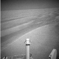
Posted by: Bill Harris Jul 1 2010, 03:22 PM
A Rovers-Eye view of the path eastward on Sol 2282.
I notice that they are also doing frequent soil Pancams and the ripple-sand looks interesting at the bottom of the sequence now that the sand is thinning out.
--Bill
|
Posted by: kungpostyle Jul 1 2010, 11:56 PM
The Planetary Society update is out:
http://planetary.org/news/2010/0630_Mars_Exploration_Rovers_Update_Spirit.html
Posted by: fredk Jul 2 2010, 04:34 AM
Some highlights from that update:
Posted by: Shaka Jul 2 2010, 06:48 AM
"Cape York"
I can dig it. Not the Garden of Eden, like Cape Trib, but appropriately dramatic.
The northernmost point of the Australian continent.
I once scrambled down the wet rocks to sit on the last one and dangle my feet in the Torres Strait.
Bonzer.
Posted by: Nirgal Jul 2 2010, 03:32 PM
As always: absolutely brilliant, elaborate and entertaining report ... can't be said often enough !
Squyres quotes like this are always heavenly music in my ears
"Drive, Drive, Drive ... " a wise man once said
Posted by: Phil Stooke Jul 2 2010, 04:06 PM
"Drive, Drive, Drive ... " a wise man once said
I said it too. You can't leave these things to the wise alone.
Phil
Posted by: Poolio Jul 2 2010, 04:13 PM
For those of you who don't follow American football, this quote is most likely a pun on the famous saying "Three yards and a cloud of dust". It refers to a style of offense where the ball carrier basically plows into the defensive line to pick up two or three yards be sheer strength and force of will. Nothing flashy. It's a style that's loved by football purists, but often derided as "boring" by those who prefer the more exciting but higher risk aerial game.
I think it's an apt comparison for our slow-and-steady rover who continues to chip away at her goal by sheer perseverance and dogged determination.
Posted by: brellis Jul 2 2010, 04:24 PM
At the rate our running back is plowing the field when are we estimating to arrive at Endeavour?
IOW: are we there yet?
Posted by: Ipparchus Jul 4 2010, 08:30 AM
Was Sol 2288 a driving day? The Sol 2288 photos are new or just old photos that have been downloaded now?
|

|
Posted by: Stu Jul 4 2010, 09:05 AM
If you're ever not sure when a particular image was taken, here's a great resource...
http://www.greuti.ch/oppy/html/filenames_ltst.htm
Paste the image number into the box provided and voila, all you could ever want to know about that image is displayed for you. :-)
Posted by: Stu Jul 4 2010, 11:54 AM
A few notes 'n thoughts on "Cape York"...
http://roadtoendeavour.wordpress.com/2010/07/04/named-where-oppy-will-make-landfall
Posted by: BrianL Jul 4 2010, 02:36 PM
Stu, those pictures came from the JPL site as being from sol 2288. So yes, it looks like Oppy drove on that day.
Posted by: Ant103 Jul 4 2010, 02:50 PM
Sol 2280 - Long pan is looooooooong. This is a view through the pancam, with L1 filter (clear), that show us a fulle 360° of the horizon.
http://www.db-prods.net/marsroversimages/Opportunity/2010/Sol2280-pancamL1-medres.jpg
An hires pic is available here (7.3 Mo) http://www.db-prods.net/marsroversimages/Opportunity/2010/Sol2280-pancamL1.jpg
We can see a lot of stuff, like a uninterrupted view of Endurance, and some distant features.
Posted by: Bobby Jul 4 2010, 06:42 PM
I have a math question to ask.
From our current position. How many 70 meter drives would it take for us to arrive
at Santa Maria Crater and The edge of Endeavour???
Thanks
Posted by: Stu Jul 4 2010, 06:46 PM
It's not as simple as that Bobby. The route to Endeavour will be a stop-start marathon, not a set-distance-a-day sprint. Variations in local topography, power levels, etc, make it just about impossible to extrapolate. The answer to "When will we get there?" is the one beloved by kid-plagued parents everywhere...
"We'll get there when we get there"...
Posted by: BrianL Jul 4 2010, 08:17 PM
Agreed, but if Oppy were to maintain a straight line, first to Santa Maria (4.8 km away) and then Cape York (11 km away), and throwing in some capricious rounding, we're looking at at about 70 such drives to Santa Maria, and 160 drives to Cape York. Which means of course that the actual number of drives to those two locations will not be those numbers, and will almost certainly be more, given that they seem to have settled around 70 m as a safe, unstressful distance for the wonky wheel. That could also change as the drive progresses.
Posted by: Stu Jul 4 2010, 08:26 PM
So... what you're saying is... we'll get there when we get there...
Posted by: brellis Jul 4 2010, 11:59 PM
So, we're not there yet?
Seriouslyer, BrianL's figures do put the distance into some perspective. The recent super res pan pic makes Endeavour seem kinda close!
Posted by: Stu Jul 5 2010, 12:16 AM
Deceptively close, yes... 
But even more seriouslyer, BrianL's figures are informative. But anyone wanting to play the "Guess How Many More Drives" game should just go to Google Earth and measure the distance between Oppy and Cape York in metres. Then divide that by 70, and there you go, ballpark figure.
Posted by: BrianL Jul 5 2010, 04:45 AM
Oh, broody herr Stu, now everyone knows the secrets of my mathematical wizardy.
Posted by: Stu Jul 6 2010, 07:27 PM
Bobby, calm down. It's a marathon, not a sprint. They'll drive when they're ready. Banging on the back of the car seat won't make them go any faster.
Posted by: stevesliva Jul 6 2010, 07:31 PM
You in the US?
I haven't gotten a single business email today. I think we're constitutionally required to celebrate our independence from Stu for this entire week.
Posted by: Stu Jul 6 2010, 07:49 PM
Posted by: Bobby Jul 6 2010, 07:52 PM
Thanks STU. That makes me feel better.
Hey STU. If the Mars Rovers were a video game. Which one would it be? Playstation, X Box or Wiiii?
Posted by: Stu Jul 6 2010, 07:54 PM
ZX81. With a wobbly RAMpack.
Posted by: SFJCody Jul 7 2010, 12:17 AM
2293 is another driving sol
Posted by: SFJCody Jul 8 2010, 11:04 PM
...and so is 2295
Posted by: Nirgal Jul 9 2010, 02:45 PM
Thanks for the updates !
BTW.: While the approximate limit of 70 meter per driving sol is well known (as explained, for example, in the latest MER report)
I'd be interesting to know what is currently the limiting factor that determines if a given sol can be used for driving ?
Is this drive-every-other-sol pattern that we see now still the same that we saw due to the "restricted sols" in the past or are there also other constraints
(possibly related to wheel-current, energy-reloading etc.) ?
If we were out of restricted sols, would it then be still be (theoretically) possible to use every non-weekend sol for driving ?
Posted by: Phil Stooke Jul 10 2010, 03:29 PM
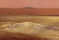
Here's the most recent view of the horizon with a bit of a stretch. Some spots on the distant landscape behind the crater... should try to find them...
Phil
|
|
Posted by: PDP8E Jul 10 2010, 04:38 PM
Phil-O-VisionTM makes everything look like the Grand Tetons !
Posted by: Phil Stooke Jul 10 2010, 04:59 PM
Yes, and it makes me wonder if Giacometti suffered from the same problem.
Phil
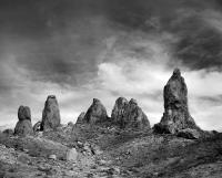
Posted by: Bobby Jul 10 2010, 09:02 PM
Phil's Image reminded me of a place in California called The Trona Pinnacles
It's in The High Desert Area of Southern California and parts of The area looks like Mars.
Here is an Image I found from that area:
|
Posted by: SFJCody Jul 13 2010, 12:16 AM
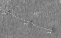
2299... another drive sol!
Let's hope the exploratorium gets fixed soon so we can actually see all this new terrain.
Posted by: Sunspot Jul 13 2010, 07:22 AM
How many drives has Opportunity made since the last picture update on the JPL website? - sol 2293
Admin advice - Go back one page in this thread and find out. Also the Oppy Map thread is a good guide. Seek and ye shall find
Posted by: jamescanvin Jul 13 2010, 09:05 PM
Yup, and according to the tracking site it was another not unsurprising 70m ESE
And another one tosol (2300!)...
Posted by: fredk Jul 14 2010, 02:24 AM
Pics are back! It looks like it's been a bumpy ride:
http://marsrovers.jpl.nasa.gov/gallery/all/1/n/2295/1N331924917EFFAKP0P1996R0M1.JPG
New MI's from the IDD work too.
Posted by: ElkGroveDan Jul 14 2010, 02:34 AM
Looks like the road to Vostok.
Posted by: djellison Jul 14 2010, 03:07 AM
Isn't it just. It's like that James Caird, Naturaliste etc area, just going backwards. It'll be like Anatolia and Fram before too long.
Posted by: brellis Jul 14 2010, 03:18 AM
(sorry Doug, I know this was probably answered years ago, but searching didn't get me to an answer)
Looking at the tread marks, it looks like they stop and dig in on a regular basis -- what causes this? Does the rover stop after every wheel rotation?
Posted by: SFJCody Jul 14 2010, 03:22 AM
There's only another km or so of regular ripples like this ahead of Oppy. After that it's 1.5km of patchy terrain (bare rock/ripples/filled in craters), and after that she'll be out on the flats!
Posted by: djellison Jul 14 2010, 03:36 AM
It's a cleat on each wheel - used to bolt the thing down to the lander. Each time the wheel turns, it just leaves that inprint behind.
Posted by: brellis Jul 14 2010, 06:50 AM
hmm, so those cleats provide clues of their own as Oppy rolls along. Also 'splains why they're offset left vs right
Posted by: walfy Jul 14 2010, 08:56 AM
I've read that they are also used to measure, on occasion, how far the rover has rolled (by imprints in the sand as viewed in the photos), and that use was anticipated when designed.
Posted by: jamescanvin Jul 14 2010, 12:16 PM
Which looks to be a carbon copy of yestersols. 70m ESE according to the tracking site.
Posted by: Stu Jul 14 2010, 03:15 PM
Some new 3D views on my blog...
http://roadtoendeavour.wordpress.com/2010/07/14/new-images-at-last
|
Posted by: PDP8E Jul 14 2010, 03:21 PM
Driving east on 7075-aluminum wheels ...

|
Here is the cleat on the machined wheel
One function is bolt down access to secure the MER to its ride; the other is visual odometry
(Wheels made by Next Intent, San Luis Obispo, CA)
Posted by: fredk Jul 14 2010, 04:04 PM
I know it's getting rather late in the rover mission now, but is it worth considering a FAQ for (non-Spirit-extraction) questions like this? For everyone who posts a question like this, I'm sure there are many readers who wonder but don't post. I'm sure we could come up with a good batch of questions.
I guess the real question is: Volunteers?
Posted by: SFJCody Jul 15 2010, 12:10 AM
...and 2301!
No doubt this helped:
http://twitter.com/MarsRovers/status/18558575893
Posted by: brellis Jul 15 2010, 12:58 AM
Has a dust devil ever been confirmed to have dumped dust onto a rover?
Posted by: Phil Stooke Jul 15 2010, 03:57 AM
Dust storms dump dust, but dust devils only raise it. Most of these cleaning events are probably just gusts, not really dust devils.
Phil
Posted by: brellis Jul 15 2010, 04:14 AM
Gotcha on the gust factor.
If the devils only raise the dust, does it only fall during the storms? I guess I'm wondering if there are "dirtying" events, separate from the big storms.
Posted by: djellison Jul 15 2010, 04:27 AM
Dust is being put into and dropping out of the atmosphere all the time basically. DD's are especially good at picking it up. Major dust storms kick up more dust and then, as they clear, dump that dust back down again.
Posted by: James Sorenson Jul 15 2010, 05:42 AM
At first, that image of the real CNC Machined wheel you provided looked a heck of a lot like ScooterLords rendered wheel. Damn did he do a good job!
http://www.unmannedspaceflight.com/index.php?showtopic=3143&st=0&start=0
Posted by: Bill Harris Jul 15 2010, 10:05 AM
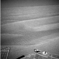
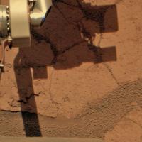
And visual confirmation of the recent cleaning event... Sol2299.
--Bill
|
Posted by: James Sorenson Jul 15 2010, 11:55 AM
Judging from the dust streaks, the gust looks like it came from the East.
Posted by: Phil Stooke Jul 15 2010, 01:05 PM
Tim Parker has posted a new route map updated to 2300:
http://marsrovers.jpl.nasa.gov/mission/tm-opportunity/images/MERB_Sol2300_1.jpg
Looking to the east there's a patch of rough-looking drifts, so I would imagine a detour to the south will be coming up very soon.
Phil
Posted by: JayB Jul 15 2010, 02:19 PM
Scott @marsroverdriver had some interesting Oppy comments on Twitter last night
#Opportunity is 40% of the way from Victoria to Endeavour. I have an idea to speed up our drives as much as 30%. Discussion tomorrow.
#A 30% speedup would shave 2-3 months off our trip to Endeavour -- maybe even more than that. Worth a try! Phyllosilicates, here we come!
Like that kind of talk
Posted by: fredk Jul 15 2010, 03:04 PM
Good catch, Bill! I didn't even bother checking the pics, since usually Oppy's cleaning events have been pretty subtle. I can't wait to hear the numbers on this event.
Edit: here's a before-and-after comparison:

|
Posted by: ElkGroveDan Jul 15 2010, 03:14 PM
Anyone have the latest power numbers? Are we back up to 900 WHrs yet for some midnight astronomy?
Posted by: fredk Jul 15 2010, 03:19 PM
I doubt we're anywhere near the 900's. We were in the mid 300's last week, and the message described it as a "little power boost". But visually it's pretty impressive. We should hear some numbers in this week's Oppy update...
Posted by: ElkGroveDan Jul 15 2010, 03:20 PM
Posted by: marsophile Jul 15 2010, 03:35 PM
There are some interesting outcrop exposures in that rough area though, and the area seems to have been peppered with impactors.
Posted by: Phil Stooke Jul 15 2010, 03:38 PM
Right, but there are outcrop exposures in safe places as well.
Phil
Posted by: kungpostyle Jul 15 2010, 05:39 PM
Power up to 492 watts
http://marsrovers.nasa.gov/mission/status.html#opportunity
Posted by: maycm Jul 15 2010, 05:52 PM
http://marsrovers.nasa.gov/mission/status.html#opportunity
The comparison to a "100 watt light bulb" is rather misleading though, isn't it?
I would prefer something that says "The rover can operate 80% of its instruments for 4 hours, or drive for 3 hours". Telling me how long a light bulb would operate gives me no clue as to how to relate it to rover operations.
Posted by: djellison Jul 15 2010, 06:04 PM
It tells people what the number actually means. It's the opposite of misleading.
And what that amount can let the rover do is self evidence by reading what the rover has actually done.... specifically
"With the extra energy from the Sol 2298 cleaning event, Opportunity was able to perform back-to-back drives on Sols 2299 and 2300 (July 12 and 14, 2010), each over 70 meters (230 feet)."
Furthermore - there are many issues besides Whrs that dictate what the rover can and can't do on a given sol. To state Xhrs of driving would be very misleading- because other factors means they can't necessarily do that every day.
Posted by: marsophile Jul 15 2010, 07:53 PM
I wonder if the cleaning event has helped to clear the dust off the MiniTes? There might be a reluctance to check this though in view of the MTES/Pancam handshake issue that led to a command sequence abort.
Posted by: fredk Jul 15 2010, 07:56 PM
That's really impressive for winter! The dust factor leapt from 58% last week to 70%. The best we could do now would be with 100% dust factor: with everything else the same, we'd get about 700 Whrs.
Posted by: Sunspot Jul 15 2010, 11:36 PM
Any theories on what this might involve doing?
Posted by: NW71 Jul 15 2010, 11:43 PM
Scott has updated his twitter;
"We are "go" to try the experiment that, if it works, drives Opportunity to Endeavour up to 30% faster (maybe even more). Pedal, meet metal."
Posted by: NW71 Jul 15 2010, 11:50 PM
Sunspot,
My first reaction was that I noticed his twitter discussed moving faster but not further, however, his latest twitter would suggest it is further (as well as possibly faster).
I do find 30% a staggering amount of improvement but I have already learnt to believe pretty much anything is possible where these rovers are concerned. After all, what's 30% when you have surpassed your longevity by 2450% ! It will be very interesting (and frustrating) if the RF wheel current would be affected (and thus negate the 30% proposed boost) in anyway by whatever Scott has in mind
I look forward to the experts on UMSF giving us their opinions.
However they try it, a successful experiment would, I don't think it's too much to suggest, rewrite all the rules yet again on this mission.
Neil
Posted by: SFJCody Jul 16 2010, 01:25 AM
Scott Maxwell's response to someone's query about what the new technique entails:
3. Image in drive direction. 4. Turn back on course. 5. If safe, drive 1m goalward. Repeat until out of time, up to 20m/sol.
All familiar pieces, just never combined this way before -- previously did hazav forward, but fwd driving hurts RF currents.
Can think of reasons it might not work, but good odds -- and if it works, the payoff could be enormous. Fun, either way :-)
As terrain becomes flatter, we'll be able to do longer blind drives, *plus* this technique, if RF wheel currents permit.
Posted by: Pertinax Jul 16 2010, 12:12 PM
I love the innovation and the attitude!
Please forgive the reiteration of an oft noted truth: It is such a treat to not only be fellow travelers on Mars, but to also have a glimpse of the innovation (and to borrow from Mike Rowe even imitation) that drives our explorers onward.
Thank you SFJCody for your post.
-- Pertinax
Posted by: MahFL Jul 16 2010, 01:15 PM
There are a million factors afecting how the rovers operate.
At the start they had about 900 watt hours, in midwinter about 240, so 492 is pretty good, enabling two 70m drives back to back, which is what most of us and the rover team wants.
Posted by: Stu Jul 17 2010, 09:01 AM
A lot more detail about the "Maxwell Plan" here...
http://roadtoendeavour.wordpress.com/2010/07/17/pedal-to-the-metal
Posted by: PaulM Jul 17 2010, 09:12 AM
I understand that if wheel damage was not an issue then it would be easy to plan 140m drives for Oppy. This has restricted Oppy's progress to 70m per day.
What has occured to me is that it would be possible to plan two rather than one 70m drives at a time and on the second day to simply to perform the second 70m drive without waiting to analyse end of drive photos. The second day's drive would be completely safe because the previous days photographic coverage from no more than 140m away would be adequate.
My plan would largely eliminate the problem of restricted SOLs.
What I have observed is that often a 70m drive day alternates with a resting day. If my plan was adopted then a cycle of driving for two days driving followed by one day resting would result in increasing the ground covered every six days from 210m to 280m.
Posted by: jamescanvin Jul 17 2010, 03:34 PM
No, the limit of 70m is because that is the maximum distance they are comfortable doing a blind drive in this terrain, to do any further auto-nav is needed which up to now has required forward drives. It is these forward drives which are a problem for the wheel currents. This is why Scott is proposing this complex plan of backwards-autonav to go further without the rover drivers getting the images and checking that it's safe. When we are out into the 'parking-lot' terrain then it is possible they could push the blind drives a little further, but I doubt they'll be >100m
Posted by: ElkGroveDan Jul 17 2010, 05:03 PM
Since we are talking about blind drives here one thing worth mentioning is that when the concept of blind driving was first planned for, the best ground resolution they had was the MGS MOC with an optimum resolution of 1.5 x 1.5 m/pixel. So the chance of surprise encounter with problematic ground relief was significant. After landing we were then fortunate to acquire some nice MOC cPROTO derived images which had a resolution of 0.5 x 1.5 m/pixel where you could start to see some smaller ground features as in this shot of http://images.spaceref.com/news/2004/R1502643merA_1mA.gif Now we have the HIRISE images with a resolution of something like 0.25 m/pixel which allows us to see the rover tracks quite clearly and in hindsight we can identify objects like Block Island from orbit.
So one of the things I've been wondering is if they have updated or narrowed the original safe driving parameters or the rules for blind drive segments in light of the ability to have a decent look at the planned drive route from above.
Secondly has there been any though of applying super-resolution image stacking techniques to a series of HIRISE images to further improve on the ground resolution which could assist in safely loosening some of the blind drive parameters. I'm sure this would require some immense logistical planning and targeting to acquire enough images under identical lighting conditions. Has anyone heard if the concept of stacking multiple HIRISE images for improved resolution has even been discussed?
Posted by: climber Jul 17 2010, 06:16 PM
I'm pretty sure this issue has been rosen here (before MRO launch IIRC) and the answer was that the technic used with MGS was not applicable to MRO... but I can't remember why...and I think it was an answer from Doug. I may be wrong but...
Posted by: stevesliva Jul 17 2010, 06:38 PM
Can't do cProto-- I think it involved slewing the camera or spacecraft-- with a pushbroom camera, but you can probably stack.
My idea with hirise was to take late day images with long shadows to emphasize drift topography, but even that's a tall order since it passes overhead at the same time every day.
Posted by: Stu Jul 17 2010, 06:39 PM
Apparently my blog has been playing up today, so if anyone has tried to access the post on Scott's plan but been unable to, here's what he wrote me:
"You probably know already that we used to do ~ 70m blind drives,
followed by an autonav segment. (Autonomous hazard avoidance, that
is.) We had to quit that because of the RF wheel currents: HAZCAMs
don't give good enough range data in Meridiani terrain to support
autonav, and the NAVCAMs have to look *forward* for autonav, because
behind us the LGA is in the way -- but we can't drive forward any
more, because it makes the RF wheel currents rise. But I thought of a
possible way around that limitation.
"Roughly, if the experiment works, here's the eventual procedure.
First, we do a long blind drive (just a little shy of 70m), followed
by a slip check. Now we're good to go another 20m, the normal
distance between slip checks.
"We slew the NCAMs around so that they're almost seeing the LGA, but
not quite, an azimuth of 162.5 degrees in rover-frame. Now we turn
*Opportunity* the remaining 17.5 degrees (clockwise) so that the NCAMs
are looking straight along our intended drive path. We image the
terrain for hazard avoidance and turn back 17.5 degrees anticlockwise.
"At this point, we're aimed (that is, our rear end is aimed) at our
destination and we have imagery in the drive direction. We do a
straight-backward step of 1m (actually 2 x 50cm steps, for technical
reasons) toward our goal, telling Opportunity to take the step only if
the hazard-avoidance imagery we took shows it to be safe. Then we
just repeat this turn/image/turn/step loop for 20m worth of driving.
"It's a little more complicated than this, because we first have to
drive about 2.5-3m blind to get onto the nav-map data (the nearest
stuff we can see looking over the rear solar panels is about 2m away)
and for other reasons, but that's the basic gist of the idea. If it
works, we can go 90m/sol rather than 70m/sol, a 29% drive-rate
improvement. There will be sols where this doesn't work -- we're
heavily constraining what Opportunity is allowed to do, and if she
sees something scary, this procedure doesn't let her drive around it;
also, the turns-in-place might elevate the RF currents, in which case
we'll have to abandon it; and there are other things that can go
wrong. But if this worked perfectly every time, it would cut nearly
40 drives out of our trek to Endeavour -- a 2-3-month savings, at
least, probably actually more than that.
"In a real blue-sky future, we can do a slip check at the 90m point,
followed by *another* 20m of hazard-avoidance driving, and so on. We
can have hazav-only drive sols, similar to what we did over
President's Day weekend in 2005. When the terrain is a little
friendlier, we can do longer blind drives before the hazard-avoidance
segment(s). And there are other possible optimizations. Right now, I
want to perform a basic experiment to see if this even works."
A HUGE thanks to Scott for taking the time to write and explain all this to me, and for us.
Posted by: ElkGroveDan Jul 17 2010, 06:41 PM
I wasn't referring to the MOC cPROTO "pitch and roll" orbiter technique which is entirely not applicable to HIRISE. I was referring to super-res stacking.of multiple images taken the same time of day.
Posted by: nprev Jul 17 2010, 06:49 PM
Thanks for sharing this, Stu, and of course many, many thanks to Scott for taking the time & effort to inform us so thoroughly & clearly!
The super-stacking question is interesting, Dan. How far can they go? Based on the discussion between Ralph & Jason over on the Titan thread (EDIT: which for some reason I can't find right now), it seems that 'resolution' is a fairly complex concept in many ways.
Posted by: djellison Jul 17 2010, 06:59 PM
I don't know is super-res techniques can be applied to bushbroom cameras at all. Framing cameras, sure, but pushbroom - I don't know. You'd have to map-project before you stacked, so at that point I think you're already working with 'pixels' that never existed anyway.
Posted by: mhoward Jul 17 2010, 08:26 PM
Good news: Exploratorium may be back up and running. Trying it out now; fingers crossed.
Posted by: Stu Jul 17 2010, 08:26 PM
Just had an email from the Exploratorium webmaster telling me that things should be up and running over there again :-) Probably a whole load of files in one monster folder, but good to be catching-up...
Posted by: fredk Jul 17 2010, 09:44 PM
A whole bunch of old images and two new ones (that I noticed) are through. The new ones are from the 2301 drive:
http://qt.exploratorium.edu/mars/opportunity/forward_hazcam/2010-07-17/1F332465473EFFALNMP1211L0M1.JPG?sol2301
Posted by: Phil Stooke Jul 18 2010, 02:21 AM
"You'd have to map-project before you stacked, so at that point I think you're already working with 'pixels' that never existed anyway. "
Doug is right about this, but the situation is not hopeless. I would work just with a small area, not a gigantic full frame. OK, so I have several HiRISE images of the same area, preferably a flat area so relief distortion will not be an issue. I would enlarge each image before doing any reprojection, so I'm not losing any information by reprojecting. When they are all perfectly registered I would sharpen them a bit and combine. The enlargement is done for super-resolution anyway, by factors up to 10x, so the only difference is the geometric reprojection, and as I say if you reproject after enlargement no information is lost. Tim Parker has a good description of the method somewhere, should be easy to find. I used it with Voyager images of, among other things, Hyperion.
You can do some interesting experiments with this technique by taking one high res image and subsampling slightly different crops of it - copy a 200x200 selection from several locations shifted by just 1 pixel each. Copy each one to its own file, and downsample it to 100x100 pixels. Now you have several different images all copied from the same source but from slightly different locations. Enlarge each one back to 200x200 using nearest neighbour interpolation and look at small details - they are sampled quite differently. But using super-resolution recombination you can get quite close to the original image.
Anyway, no reason why it would not work with HiRISE. Maybe I'll have a go.
Phil
Posted by: ElkGroveDan Jul 18 2010, 02:30 AM
You might select an area where we already have ground truth imagery and a wide range of < 1.0 meter objects to inspect the lower boundaries of the improved resolution. Possibly the cobbles around the rim of Victoria.
I'll pay your Starbucks bill for that day.
Posted by: brellis Jul 18 2010, 04:53 AM
dang, that sounds like work.
Posted by: Phil Stooke Jul 19 2010, 12:14 AM
Work? If it was work I'd be trying to get out of it.
Phil
Posted by: alan Jul 19 2010, 12:19 AM
No updates the last three sols, at JPL or the tracking site, did one of the orbiters go into safe mode again?
Posted by: mhoward Jul 19 2010, 12:23 AM
It was mentioned on Twitter that ODY is in safe mode.
Posted by: jamescanvin Jul 19 2010, 07:55 PM
I feel like I'm danger of forgetting how to do MER image processing it's been so long since I've had any time to do any! Here is a very quick go at the sol 2300 drive direction mosaic to try and help me remember the procedure.
http://www.nivnac.co.uk/mer/index.php/b2300
James
Posted by: Zeke4ther Jul 19 2010, 09:58 PM
You still have not lost your touch!
Posted by: ElkGroveDan Jul 20 2010, 12:45 AM
James' image looked so sharp I thought I'd have a Stooke-ish look (5x) at the horizon and begin the hunt for Cape York.
So could this be it? It's roughly about where Stu and I both predicted it would appear (the bump on the right appears to be an artifact of James' stitching of the pan.) The rise above the horizon looks clearest in the L2 image which I have included without rotating so as not introduce any pixel flutter whatsoever. The slight color difference from the foreground sand is compelling.

|

|
Posted by: Stu Jul 20 2010, 05:16 AM
VERY good eyes, Dan... looks like a good candidate for Landfall to me.
Posted by: fredk Jul 20 2010, 06:15 AM
I'm a bit sceptical, since there are similar "bumps" to the left in the L2 image. A big dune perhaps? Let's definitely keep an eye on it.
My own gut instinct is that we will see York sooner rather than later...
Posted by: jamescanvin Jul 20 2010, 09:03 PM
No, I don't think this bump is in quite the right place, it would line up with the very north 'shore' of Cape York the high points of the cape should appear further to the right. There are a few large ripples 3-500m along that azimuth, one or the other of those would be my guess as an id.
James
Posted by: empebe Jul 22 2010, 01:07 PM
Mike
Posted by: fredk Jul 22 2010, 08:11 PM
More sol 2301 pics are finally at exploratorium:
http://qt.exploratorium.edu/mars/opportunity/navcam/2010-07-22/1N332460220EFFALNMP0665R0M1.JPG?sol2301
Posted by: Tesheiner Jul 22 2010, 08:59 PM
A big bunch of pictures were downlinked a few hours ago. That means ODY is out of safe-mode and back to business.
And let me paste here one of the last entries from Scott Maxwell's twitter here: "Wrote the probably-final version of our 30% drive-speedup experiment. We're on track to try the experiment Friday."
Posted by: fredk Jul 23 2010, 08:08 PM
What the...???
http://qt.exploratorium.edu/mars/opportunity/pancam/2010-07-23/1P332460904EFFALNMP2369R2M1.JPG?sol2301
http://qt.exploratorium.edu/mars/opportunity/pancam/2010-07-23/1P332460904EFFALNMP2369L2M1.JPG?sol2301
It appears in both L2 and R2 frames! DD at Meridiani?!?
Posted by: fredk Jul 23 2010, 08:22 PM
Here's the average of the L2 and R2 frames, then contrast stretched a bit:

|
Posted by: djellison Jul 23 2010, 09:28 PM
Yup - I think that's our first obvious Meridiani DD 
Posted by: fredk Jul 23 2010, 09:56 PM
If you flip between the two frames, the DD doesn't jump back and forth visibly relative to the Endeavour rim:

|
Also it doesn't seem to extend below the visible horizon. This all suggests that it's really far away, which would mean it's really big.
Maybe this means that to get DD's going here, we need the more extreme topography of Endeavour crater. If we're lucky it'll mean more cleaning events/gusts as we near Endeavour!
Posted by: marswiggle Jul 23 2010, 10:37 PM
A cropped x-eyes stereo view. The dust plume really seems to be very distant, maybe even inside the Endeavour (don't know though if that is possible as to the physical factors involved).

|
Posted by: djellison Jul 23 2010, 11:10 PM
If it were inside endeavour - then it would be utterly utterly enormous. It's probably a KM or two away, no more than that.
Posted by: Bill Harris Jul 23 2010, 11:14 PM
"Dust devils"-- cyclonic thermals (Sun heats the surface, warm air rises and the rising bubble of air develops a coriolis spin) occur frequently at Meridiani. They are not as visible as at other places because there is less available dust on the Endurance-Victoria plain due to the desert pavement (armoring) of the Blueberries on the surface.
Depends, of course, on what you mean by "dust devil"-- the visible dust plume or the rising thermal. My opinion is that it is thermal activity that defines.
Attached is an enhanced MOC image of the area SW of Endurance crater showing (faint) dust devil tracks...
--Bill
|
Posted by: brellis Jul 23 2010, 11:45 PM
Thanks Bill -- you've swept away many grains of misunderstanding! So, if a DD travels along a dusty bed inbetween BB outcroppings, it might gain visibility?
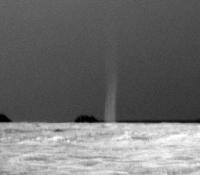
Posted by: fredk Jul 24 2010, 12:28 AM
Thanks for the info, Bill. I hadn't recalled either ground or orbital images of DDs at Meridiani. (And I do believe this is the first ground sighting.)
As far as the semantics, doesn't it seem that a dust devil should have dust?

Posted by: djellison Jul 24 2010, 12:39 AM
Sorry - yes - I should have been more specific - I meant seen from the ground.
Posted by: Deimos Jul 24 2010, 03:25 AM
Very good. Once we get through the data crunch, maybe we can run some of the DD sequences with Opportunity again. Personally, I've seen terrestrial dust devils, snow devils, and trash devils. So count me among those who give meaning to the word "dust" and do not mean "vortices". However, it is not obvious there is vorticity in the image. It has sort of the right shape, but still could be a gust. Hmm, more imaging, definitely.
We did see dust lifting by gusts within Victoria. Definitely no dust devils, but still some dust gusts--not like this, though.
Posted by: Bill Harris Jul 24 2010, 04:54 AM
It may be a semantical distinction, but given that we can have (as noted) "terrestrial dust devils, snow devils, and trash devils" the common factor is not which disturbed material was making it visible, but the convective motion of the air.
With Spirit we developed the software routines to detect and image dust devil-specific events, which could be used here, too.
--Bill
Posted by: Stu Jul 24 2010, 06:55 AM
(raises hand meekly from the back of the class)
What about an impact? Might that be a cloud of dust dispersing after a small meteorite whumped into the plain up ahead?
Just thinking outloud, don't look at me like that...
In the meantime, new colourised pan here...
http://twitpic.com/284kwe/full
Posted by: brellis Jul 24 2010, 08:11 AM
From such a distance, it does look a bit wide compared to the little DD's imaged from Spirit's locale...
Posted by: Stu Jul 24 2010, 09:52 AM
...and in widescreen-o-vision...
|
|
Posted by: Phil Stooke Jul 24 2010, 11:08 AM
Here's another view of dd tracks at Meridiani - a CTX image with Endurance at the middle. Image number is in the file name.
Phil

|
Posted by: Bill Harris Jul 24 2010, 02:32 PM
Very good, Phil. I've been needing to avaliable images to locate other DD tracks in the area.
Here is an earlier image to compliment the MOC image I posted yesterday. It adds an element of time in the DD tracks observation.
--Bill

|
Posted by: fredk Jul 24 2010, 02:56 PM
I agree that inside Endeavour is unlikely for this DD. But looking at this image, it appears that there's something of a "dust devil alley" to our east-northeast, beginning roughly around mini-Endurance:

|
The sighting on sol 2301 was looking almost directly east, straight into the alley. If the DD was at the near end of the visible DD alley, around 3.5 km away, it would be about 50 metres wide, which sounds believable from what I recall of Gusev devils.
Hopefully this means things will get gusty as we approach mini Endurance. I suppose it's not entirely clear if this "DD alley" really gets more devils due to topography, or if their tracks are just more visible on the surface there for some reason.
Posted by: ElkGroveDan Jul 24 2010, 03:49 PM
Rover Heaven. Ground as flat as a parking lot, and frequent gusts to clean off the solar panels.
But like watching a film where everything is going just a little TOO well for the hero, I keep getting an ominous feeling that the evil Dr. Entropy is lurking somewhere just out of view to thwart our quest.
Posted by: Bobby Jul 24 2010, 04:41 PM
I have a question regarding Mini Endurance.
From all the images we have of the hills of Endeavour Crater and the road ahead to it.
Can anyone show in those images what direction Mini Endurance is?
I wonder if we can see any part of Mini Endurance yet like a raised rim? Will she have
the same look Endurance had when we approached her eons ago??? I think it would be
fun to be the first person to spot her.
I would also like to say thanks to all the Image Experts in UMSF for doing an
awesome job and look forward to the amazing images to come as we get closer to
Endeavour Crater.
Thanks,
The Quiet One Bobby.
Posted by: fredk Jul 24 2010, 05:27 PM
Good question, Bobby. I estimate mini Endurance/Santa Maria should be in very roughly the middle of this frame:
|
|
It should appear very roughly as wide as the white bar. No obvious signs yet, but we'll certainly have to keep our eyes open.
It does seem to have something of a raised rim, maybe similar to Endurance, so it should be visible from a good distance.
(Maybe this should be in distant vistas, although Santa Maria is becoming a relatively nearby destination...)
Posted by: Bobby Jul 24 2010, 05:57 PM
From where we are at now. How far away are we from mini Endurance/Santa Maria???
Posted by: djellison Jul 24 2010, 06:14 PM
You could measure it yourself with Google Earth and ET's maps.
Posted by: Phil Stooke Jul 24 2010, 06:35 PM
True! Or go to post 5 on page 1 of this very thread for a map with a 1 km grid, very easy to measure from.
Phil
Posted by: djellison Jul 24 2010, 06:36 PM
Give a man a fish, he'll eat for a day. Give him a net, he'll feed himself for a lifetime. Or something.
Posted by: Phil Stooke Jul 24 2010, 06:38 PM
He'll get all tangled up in it and drown?
Phil
Posted by: djellison Jul 24 2010, 06:53 PM
Hey - at least he doesn't come back asking for another fish.
Posted by: Bobby Jul 24 2010, 07:01 PM
LOL. You guys are silly and thanks for the info
Posted by: ElkGroveDan Jul 24 2010, 08:33 PM
Give a man a fish and he'll put it in the freezer whereupon his wife will throw it out sometime next spring. But teach a man to fish and he'll always be wanting to borrow your boat. Mind your own business though, and such people will leave you alone.
Posted by: brellis Jul 24 2010, 09:19 PM
They found fish on Mars? 
Posted by: Bobby Jul 24 2010, 09:29 PM
They found a pool of water under a bedrock there and found Flipper swimming around
Posted by: Phil Stooke Jul 24 2010, 09:39 PM
Thanks for all the fish!
Phil
Posted by: Stu Jul 24 2010, 10:18 PM
Interesting rocky debris over there...
|
Probably a bit hard to get to, tho...

|
And a colour view...
http://twitpic.com/28cade/full
Posted by: ElkGroveDan Jul 24 2010, 11:13 PM
What rocky debris? I don't see any rocky debris...
OH LOOK! up ahead! I think I see a sign that says "Free beer for rover drivers while quantities last - Cape York Cantina."
Posted by: fredk Jul 24 2010, 11:19 PM
I think we're OK, Dan, we're well past that crater now - it's the white arrowed feature here:
|
Posted by: Stu Jul 25 2010, 06:17 AM
OH LOOK! up ahead! I think I see a sign that says "Free beer for rover drivers while quantities last - Cape York Cantina."
I might be wrong, but I thought I detected a slight reluctance to stop there, Dan...
Posted by: Bill Jul 25 2010, 09:11 AM
The name of this now 140m away crater is Pond Inlet
Posted by: Stu Jul 25 2010, 09:35 AM
Thanks Bill and Fred, appreciate the extra info.
Posted by: Ant103 Jul 25 2010, 01:52 PM
I'm back from Rotterdam (and an extra time in cities in France) and I can process again.
So, Sol 2301 in color, with the dust-devil
http://www.db-prods.net/marsroversimages/Opportunity/2010/Sol2301-pancam.jpg
Posted by: Explorer1 Jul 25 2010, 08:43 PM
From Wikipedia:
The naming theme remains consistent! (Polar explorers)
Posted by: Deimos Jul 26 2010, 02:43 AM
Going back a couple days ... I mentioned thinking the dust devil may be a gust. I don't think so any more, as a result of an accidental 4:1 reduction in the horizontal dimension of the image. Maybe y'all saw this clearly already, but this is what did it for me. The request for movie/watch activity is in.
|
Posted by: alan Jul 26 2010, 02:46 AM
Sol 2311 was a drive day. New trick is apparent in the forward hazcam.
http://qt.exploratorium.edu/mars/opportunity/forward_hazcam/2010-07-25/1F333348846EFFALRQP1205R0M1.JPG
Posted by: fredk Jul 26 2010, 03:01 AM
It looks like the distance was only around 30 m, based on the images. Perhaps this first trial was meant to be a short drive?
Posted by: jamescanvin Jul 26 2010, 08:10 AM
Yeah, if I'm reading the tracking data right, about 20m blind then 10m reverse-auto. I can only imagine that it was an intentionally short first test. They probably wanted a good view of the terrain they were going to test the technique on, rather than doing it on entirely unknown ground (as envisaged eventually) on the first try.
Posted by: JayB Jul 26 2010, 05:38 PM
Scott's latest tweet
" marsroverdriver - Good news: drive-speedup experiment worked. Still must closely examine data for nasty surprises, but this is a big step! "
Posted by: MahFL Jul 27 2010, 10:50 AM
Cool, lets go !
Posted by: marsophile Jul 27 2010, 07:30 PM
The MER rovers can be driven forwards or backwards; I've been wondering whether they can be driven sideways. That is, can all six wheels be turned left by, say, 10 degrees, and the rover driven in a straight line at an angle of 10 degrees to its head/tail orientation? This is mainly idle curiosity, but it was stimulated by the news about the new backwards auto-navigation technique that involves rotating the rover to get an unobstructed backward view.
Posted by: walfy Jul 27 2010, 07:44 PM
The center wheel on each side can only steer in one direction, so I don't think it can do it unless the four corner wheels drag them along.
Posted by: elakdawalla Jul 27 2010, 07:56 PM
I have seen some prototype rovers at the JPL robotics lab that can do what you're describing (which is usually referred to as "crab-walking"). I have a photo of one called Pluto doing that in http://www.planetary.org/blog/article/00001010/.
Posted by: jamescanvin Jul 27 2010, 08:41 PM
Sol 2311 R21 drive direction:
http://www.nivnac.co.uk/mer/index.php/b2311
Posted by: fredk Jul 27 2010, 09:09 PM
The centre wheels can't steer at all. They can only drive forwards or backwards.
Posted by: kenny Jul 27 2010, 10:50 PM
I've been away and missed the fish chat... but I feel I must retort.
Sell a man a fish, and you feed him for a day. Teach a man to fish, and you've lost a valuable business opportunity...
Posted by: Ant103 Jul 28 2010, 01:01 PM
My version of Sol 2311 drive direction
http://www.db-prods.net/marsroversimages/Opportunity/2010/Sol2311-pancam.jpg
Posted by: charborob Jul 28 2010, 03:54 PM
In the latest batch of images on Exploratorium, I find series of images pointed in the same direction spaced about 30 seconds apart. Looking for DDs?
Posted by: fredk Jul 28 2010, 05:34 PM
Do you mean the L6 pancam series? Those are super-resolution sequences, much like the previous ones. Normally they use a series of navcams to search for DDs because of the wider field of view. But I'm sure they'd be thrilled if a DD made an appearance in the L6's...
Posted by: Deimos Jul 28 2010, 05:40 PM
Sounds like L6 the superres, in which I saw no DDs. Tosol has some navcam DD frames, but most of them are lower priority (as usual).
Posted by: Stu Jul 28 2010, 06:18 PM
Is there a super-res sequence planned of the area in which Cape York is going to appear? I'd have thought you guys would be keen to bag it
Posted by: Phil Stooke Jul 28 2010, 06:45 PM
Maybe when it actually becomes visible?
Phil
Posted by: fredk Jul 28 2010, 08:45 PM
As far as I can tell, the direction to York should be in one of the new super-res views. It should appear in the left part of this frame:
http://qt.exploratorium.edu/mars/opportunity/pancam/2010-07-27/1P332189506ESFAKVTP2364L6M1.JPG?sol2298
It's conceivable that the official super-res will show a tiny bit of York just peeking above the horizon.
Posted by: Stu Jul 28 2010, 08:46 PM
Bits of it probably are visible now, if we look carefully enough.
Posted by: Astro0 Jul 28 2010, 11:23 PM
And if we close our eyes and click our heels together three times....
..."There's no place like Cape York. There's no place like Cape York."
Posted by: SFJCody Jul 28 2010, 11:29 PM
Wow! Look what's happening on 2315!
Sol Seq.Ver ETH ESF EDN EFF ERP Tot Description
----- -------- --- --- --- --- --- ---- -----------
02315 p0027.01 0 0 0 0 0 0 mer_b_sunfind_parms_left_eye_modified_exp
02315 p0027.01 0 0 0 0 0 0 mer_b_sunfind_parms_left_eye_modified_exp
02315 p0027.01 0 0 0 0 0 0 mer_b_sunfind_parms_left_eye_modified_exp
02315 p0027.01 0 0 0 0 0 0 mer_b_sunfind_parms_left_eye_modified_exp
02315 p0027.01 0 0 0 0 0 0 mer_b_sunfind_parms_left_eye_modified_exp
02315 p0663.03 6 0 0 6 0 12 navcam_3x1_az_108_3_bpp
02315 p0663.03 6 0 0 6 0 12 navcam_3x1_az_108_3_bpp
02315 p0663.03 6 0 0 6 0 12 navcam_3x1_az_108_3_bpp
02315 p0663.03 6 0 0 6 0 12 navcam_3x1_az_108_3_bpp
02315 p0663.03 6 0 0 6 0 12 navcam_3x1_az_108_3_bpp
02315 p1154.01 2 0 0 2 0 4 front_hazcam_idd_unstow_doc
02315 p1154.01 2 0 0 2 0 4 front_hazcam_idd_unstow_doc
02315 p1162.00 1 1 0 0 0 2 flhaz_IDD_check_subframe_loco_pri_18
02315 p1162.00 1 1 0 0 0 2 flhaz_IDD_check_subframe_loco_pri_18
02315 p1205.08 2 0 0 2 0 4 front_haz_penultimate_0.5_bpp_pri17
02315 p1205.08 2 0 0 2 0 4 front_haz_penultimate_0.5_bpp_pri17
02315 p1205.08 2 0 0 2 0 4 front_haz_penultimate_0.5_bpp_pri17
02315 p1205.08 2 0 0 2 0 4 front_haz_penultimate_0.5_bpp_pri17
02315 p1205.08 2 0 0 2 0 4 front_haz_penultimate_0.5_bpp_pri17
02315 p1211.03 2 0 0 2 0 4 ultimate_front_haz_1_bpp_pri_15
02315 p1212.09 2 0 0 2 0 4 front_haz_ultimate_2_bpp_pri15
02315 p1212.09 2 0 0 2 0 4 front_haz_ultimate_2_bpp_pri15
02315 p1212.09 2 0 0 2 0 4 front_haz_ultimate_2_bpp_pri15
02315 p1212.09 2 0 0 2 0 4 front_haz_ultimate_2_bpp_pri15
02315 p1214.05 2 0 0 2 0 4 front_haz_ultimate_4bpp_pri15
02315 p1214.05 2 0 0 2 0 4 front_haz_ultimate_4bpp_pri15
02315 p1214.05 2 0 0 2 0 4 front_haz_ultimate_4bpp_pri15
02315 p1214.05 2 0 0 2 0 4 front_haz_ultimate_4bpp_pri15
02315 p1214.05 2 0 0 2 0 4 front_haz_ultimate_4bpp_pri15
02315 p1254.02 2 0 0 2 0 4 front_haz_fault_pri15_4bpp
02315 p1254.02 2 0 0 2 0 4 front_haz_fault_pri15_4bpp
02315 p1254.02 2 0 0 2 0 4 front_haz_fault_pri15_4bpp
02315 p1254.02 2 0 0 2 0 4 front_haz_fault_pri15_4bpp
02315 p1254.02 2 0 0 2 0 4 front_haz_fault_pri15_4bpp
02315 p1301.06 2 0 0 2 0 4 rear_haz_penultimate_1bpp_pri17
02315 p1301.06 2 0 0 2 0 4 rear_haz_penultimate_1bpp_pri17
02315 p1301.06 2 0 0 2 0 4 rear_haz_penultimate_1bpp_pri17
02315 p1301.06 2 0 0 2 0 4 rear_haz_penultimate_1bpp_pri17
02315 p1301.06 2 0 0 2 0 4 rear_haz_penultimate_1bpp_pri17
02315 p1312.07 2 0 0 2 0 4 rear_haz_ultimate_2_bpp_pri15
02315 p1312.07 2 0 0 2 0 4 rear_haz_ultimate_2_bpp_pri15
02315 p1312.07 2 0 0 2 0 4 rear_haz_ultimate_2_bpp_pri15
02315 p1312.07 2 0 0 2 0 4 rear_haz_ultimate_2_bpp_pri15
02315 p1312.07 2 0 0 2 0 4 rear_haz_ultimate_2_bpp_pri15
02315 p1354.01 2 0 0 2 0 4 rear_haz_fault_pri15_4bpp
02315 p1354.01 2 0 0 2 0 4 rear_haz_fault_pri15_4bpp
02315 p1354.01 2 0 0 2 0 4 rear_haz_fault_pri15_4bpp
02315 p1354.01 2 0 0 2 0 4 rear_haz_fault_pri15_4bpp
02315 p1354.01 2 0 0 2 0 4 rear_haz_fault_pri15_4bpp
02315 p1961.19 2 0 0 2 0 4 navcam_mid_drive_tracks_3_bpp_pri_42
02315 p1961.19 2 0 0 2 0 4 navcam_mid_drive_tracks_3_bpp_pri_42
02315 p1961.19 2 0 0 2 0 4 navcam_mid_drive_tracks_3_bpp_pri_42
02315 p1961.19 2 0 0 2 0 4 navcam_mid_drive_tracks_3_bpp_pri_42
02315 p1961.19 2 0 0 2 0 4 navcam_mid_drive_tracks_3_bpp_pri_42
02315 p1991.07 4 0 0 4 0 8 nav_2x1_rvraz_0_1_bpp_pri42
02315 p1991.07 4 0 0 4 0 8 nav_2x1_rvraz_0_1_bpp_pri42
02315 p1991.07 4 0 0 4 0 8 nav_2x1_rvraz_0_1_bpp_pri42
02315 p1991.07 4 0 0 4 0 8 nav_2x1_rvraz_0_1_bpp_pri42
02315 p1991.07 4 0 0 4 0 8 nav_2x1_rvraz_0_1_bpp_pri42
02315 p2601.05 4 2 0 0 2 8 pancam_tau_L78R48
02315 Total 140 4 0 134 2 280
Posted by: djellison Jul 28 2010, 11:52 PM
Take out the repeats, and it looks fairly normal
Posted by: Ant103 Jul 29 2010, 12:43 AM
I've took the frames that are constituting actually a super-res pan to produce it. The colors are from the same sol.
This was processed with Keiths Image Stacker (align & stacking + Laplacian pyramid sharpen), Gimp (GREYstoration -denoise-, colors), Hugin (pano).
The result is this following image :
http://www.db-prods.net/marsroversimages/Opportunity/2010/Sol2298-superrespan-11-16img-KIS-LS-denoise-coul.jpg
I think we can see Cape York. But not sure if true.
Posted by: Astro0 Jul 29 2010, 12:58 AM
Very nice Ant!!
Here's just a little thought from Oppy
|
Posted by: Phil Stooke Jul 29 2010, 01:25 AM
Very nice, Ant - but my impression is that we still have to go a bit further before we see Cape York. Not far, though, we'll see it soon.
Phil
Posted by: fredk Jul 29 2010, 01:35 AM
Ant, that's stunning. You saved me a lot of work compiling those superres frames. And colour, too!
Posted by: antipode Jul 29 2010, 02:42 AM
What are we seeing here? (dead center of the left hand - northern - pan). Crop and 3x vertical stretch - no other processing.
P
ADMIN: Please note: inline image removed and replaced as an attachment.

|
Posted by: Stu Jul 29 2010, 05:23 AM
..."There's no place like Cape York. There's no place like Cape York."
Hehe...
Posted by: jamescanvin Jul 29 2010, 07:47 AM
If your referring to the mark on the near horizon (as opposed to that distant crater beyond Endeavour) then my guess (without doing any complex analysis) is a particularly large ripple I can see in the maps in that direction about 700m away.
I don't see any sign of Cape York, although much of it would (I think) be off the edge of Ant's image.
Posted by: Bill Harris Jul 29 2010, 02:26 PM
Ignoring the Distant Vistas for the moment, as any decent geologist would do Oppy scuffs the dirt with her boot and notices...
...the largest hematite concretion we've seen thus far.
Hmmm...
|
Posted by: Ant103 Jul 29 2010, 03:29 PM
Hmmmmm again by seeing the dramatic effect of the wind to the scuff made by Oppy recently.
Here is the two pic. Sol 2296
http://www.db-prods.net/marsroversimages/Opportunity/2010/1P332011728EFFAKVTP2572LCoul.jpg
Sol 2299
http://www.db-prods.net/marsroversimages/Opportunity/2010/1P332278799EFFAKVTP2573LCoul.jpg
And a video to see this in "motion" (approx. 1.4 Mo, H.264)
http://www.db-prods.net/marsroversimages/Opportunity/2010/WindErosion-sol2296-2299.mov
Ps : thanks for appreciate the super-res pan .
Posted by: Stu Jul 29 2010, 03:46 PM
|
Can't help wondering if that's meteoritic rather than a concretion, especially with that fragment next to it...but this isn't really my area, I'll admit quite happily
Posted by: fredk Jul 29 2010, 04:33 PM
Amazing amount of movement! Thanks, Ant, for pointing that out. Just to remind folks, the big recent cleaning event was sol 2298, so in between those two views. It was lucky they managed to bracket the event like that.
Posted by: Bill Harris Jul 29 2010, 05:45 PM
I noticed that "softening" of the disturbed soil, but couldn't decide if it was wind or "physical slumping" that caused that "decrepitation". Not the terms I'm looking for, I'm at a loss to recall the terminology. But there are little details that don't look windblown.
PS:...I want to call it "efflorescence", too, but that's not right, either. And has loaded connotations...
Posted by: Ant103 Jul 29 2010, 08:57 PM
Sol 2314 view of Endeavour
http://www.db-prods.net/marsroversimages/Opportunity/2010/Sol2314-pancam.jpg
Posted by: brellis Jul 29 2010, 10:20 PM
This is like Lawrence of Arabia!
Posted by: Phil Stooke Jul 29 2010, 10:46 PM
And why not? Arabia Terra is next door to Meridiani Planum.
Phil
Posted by: fredk Jul 30 2010, 03:49 AM
From the http://marsrovers.jpl.nasa.gov/mission/status_opportunityAll.html#sol2308, the dust factor is continuing to climb (although that might be due to the tau recalibration?):
And from http://twitter.com/marsroverdriver/status/19860299608:
Posted by: Explorer1 Jul 30 2010, 05:12 AM
Or Dune, with the whole 'avoid the sand, go on the rock' method of travel.
Though I doubt sandworms are very likely here.
Posted by: Deimos Jul 30 2010, 03:55 PM
Yes, there a sort of a conservation of dust in the models. Dust coming off the window goes into the sky in the model of the Sun images. Dust going into the sky comes off the deck in the power models. Opacity was off for a while, it was just hard to find a good time to switch in the new calibration. Surprising people with a "dust storm" and "cleaning event" that are only in the models is a bad thing. But tau was reported around 0.2, when seasonal averages suggested 0.4. Accounting for dust coming off the pancam put this year right on top of previous years (with occasional brief spikes, as seen previously). Sadly, there's still plenty of dust on the window, although the deck seems to be looking good.
Posted by: fredk Jul 30 2010, 04:31 PM
Thanks, Deimos, it's always interesting to hear what goes into the numbers like that. It makes me curious what kinds of uncertainties the team puts on the tau and dust factor values. Regardless, the relative change in dust factor after a real cleaning event like on 2298 is unambiguous, I guess. And the one number that presumably doesn't depend on any modelling is the Whrs/sol, even as the tau and dust factor that make it up do. And 533 is a very comfortable number.
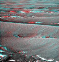
Posted by: Stu Jul 31 2010, 06:10 AM
Has Oppy been watching some old episodes of "The Dukes of Hazzard"?
|
Posted by: Astro0 Jul 31 2010, 09:47 AM
So Stu, are you saying that Oppy's recent sighting of a DD was really 'Daisy Duke'!?!
Posted by: tdemko Jul 31 2010, 12:53 PM
Maybe Oppy should hold off on the "NASCAR-victory-burn-out-spins" until she actually reaches the crater...
Posted by: Stu Aug 1 2010, 06:54 AM
Awww, let her have her fun. She's earned a bit of binkying.
Meanwhile, I think is is "Valparaiso", next target for intense study...?
|
Posted by: nprev Aug 1 2010, 08:19 AM
Re the "Dukes of Hazzard" shot...Yee-haw!!!  (Great anaglyph, Stu!)
Seriously, that's one hell of a scary-looking digout. Look at how the tracks are along the sides of the larger trench. Wild speculation: Is this an artifact of drive s/w improvements? It almost looks like she turned into the skid & downslope (which of course would be the proper response to the situation), and it doesn't look like she loitered there waiting for advice from Earth to make the move.
Posted by: fredk Aug 1 2010, 02:32 PM
Stu, you've pretty much nailed the colour on that new image. I know you don't aim for it, but that's really close to the calibrated colour we've seen.
Posted by: Stu Aug 1 2010, 02:46 PM
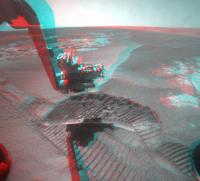
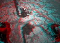
Thanks Fred, appreciate that. I thought myself at the time "Hmmm, that looks pretty realistic", but got there purely by good luck as you guessed!
Here's a nice (I think, anyway!) view of Oppy's instruments about to begin their work...
|
Posted by: ElkGroveDan Aug 1 2010, 05:03 PM
I assume this is Scott's new maneuver we are looking at.
Posted by: Phil Stooke Aug 1 2010, 05:40 PM
No, I think just getting to the right place for the IDD work. The new drive thingy was the previous drive.
Phil
Posted by: Bill Harris Aug 1 2010, 06:22 PM
I don't see anything unusual about the MIs taken on the Sol 2317 stop, nor anthing out of the ordinary on the Panmcam context images. I figure that they are documenting the close-up appearance of the bedrock since the gross appearance is subtlely changing.
--Bill
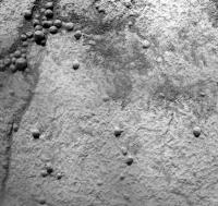
|
Posted by: fredk Aug 1 2010, 06:27 PM
Yeah, "Dukes of Hazard" (DoH?) maneuver = "J-shaped bump" mentioned http://twitter.com/marsroverdriver/status/19860299608
That's actually pretty lame for a DoH maneuver. If Oppy really wanted to get into the spirit, she should've taken a good long run at a big dune and gotten some serious air-time.
Posted by: djellison Aug 1 2010, 09:55 PM
When we see that ( and it's happened once ) we'll have a long normal drive - and then a drive that's like the old drunken sailor walk, but magnified a LOT. It'll be 17.5 deg turn off direction and then back again, then 1m drive, then 17.5 deg off, 17.5 deg back - 1m drive.
==/\==/\==/\==/\ that sort of thing. HOWEVER - because the rover itself is more than 1m long, it'll result in a messy trail. It'll be very obvious out the rear mirror once we've done it for 10-20m or so.
Posted by: serpens Aug 2 2010, 05:03 AM
PS:...I want to call it "efflorescence", too, but that's not right, either. And has loaded connotations...
Could this event be attributed to the electrostatic influence from a dust devil which could disrupt the electrostatic attraction between individual dust grains while at the same time providing the wind force necessary to move the freed up particles? Such may explain the 'decrepitation'.
Posted by: Phil Stooke Aug 2 2010, 02:47 PM
So glad to see our route mapper Tesheiner back with us! And on his new map, Alert Bay and Port Hardy - Hah, I used to live up in that area. Winter Harbour actually - rather an interesting place.
Phil
Posted by: Stu Aug 3 2010, 05:51 AM
Welcome back, Tesh, really missed your updates!
Couple of pics to start the day... On this first one, is that light flash a reflection off part of the rover? Light sneaking through a gap in it? Pretty, wherever it's from...

|
And an interesting 3D view of one of the rocky plates' edges...
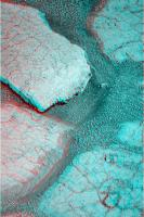
|
Posted by: Astro0 Aug 3 2010, 05:54 AM
Hey Stu,
You missed it man! The light reflection image is upsidedown.
It reads 'AI'...obviously a message as Oppy becomes self-aware
Posted by: elakdawalla Aug 3 2010, 06:11 AM
Which is why it took an Aussie to notice the message
Posted by: Astro0 Aug 3 2010, 06:27 AM
Wait!?! Which one of us is upsidedown?
Posted by: BrianL Aug 3 2010, 12:49 PM
Would Uranians debate who is left or right?
Posted by: Tesheiner Aug 3 2010, 02:50 PM
And I come back from vacations just to find that ... you all need some.
Now seriously, this following sol 2320 is planned for driving. Hope for a loooong one.
Posted by: Phil Stooke Aug 3 2010, 03:49 PM
"Wait!?! Which one of us is upsidedown?"
Which one of you is hanging on to the ground to stop yourself falling into the sky?
(hint - I know I'm not)
Phil
Posted by: fredk Aug 3 2010, 04:28 PM
I tend to agree with Phil - it's just common sense that it's those down-under's who are upside-down.
But something's always worried me about this. If you look at a globe (be sure to hold it the right way up), those of us at a respectable 40-50 degrees north should actually be having a hard time clinging to the ground sloping 40-50 degrees towards the south. I suspect something's amiss...
Posted by: climber Aug 3 2010, 04:45 PM
Yes, I still can't understand why the Rovers, scheduled for less than 30° slopes, still hold where there are: this has to be the biggest discovery of the MER program.
Posted by: Phil Stooke Aug 3 2010, 07:53 PM
The song "I'm Sitting on top of the World" was apparently composed at the latitude of Mississippi. So that should tell us something useful.
Phil
Posted by: brellis Aug 3 2010, 09:15 PM
This thread is now six degrees from everywhere!
and, welcome back Tesh!
Posted by: fredk Aug 4 2010, 04:08 AM
Hard to locate us from these few images, but it could be a long drive:
http://qt.exploratorium.edu/mars/opportunity/forward_hazcam/2010-08-03/1F334147541EFFAMFCP1205R0M1.JPG?sol2320
Posted by: jamescanvin Aug 4 2010, 07:34 AM
71m according to the tracking data. I don't see any signs of 'Maxwell motion' in the tracks - just a standard drive this time by the looks of it.
Posted by: Tesheiner Aug 4 2010, 08:32 AM
http://qt.exploratorium.edu/mars/opportunity/forward_hazcam/2010-08-03/1F334147541EFFAMFCP1205R0M1.JPG?sol2320
A polar view of the navcam mosaic is very helpful to pinpoint the rover's position on a HiRISE image at 25cm/pix. The dune crests match quite well.
Posted by: fredk Aug 4 2010, 02:27 PM
I should have said "hard for me to locate us". It's another matter for our resident expert, of course!
Posted by: Tesheiner Aug 4 2010, 06:02 PM
Ahh! This is music to my ears.
From http://twitter.com/marsroverdriver: We have a whopping 3 hours of drive time today, so we're trying a full version of our Oppy drive-distance improvement strategy. Woo-hoo!
Posted by: SFJCody Aug 5 2010, 07:05 AM
100 drives of 100 metres and they would pretty much be there
Posted by: jamescanvin Aug 5 2010, 07:21 AM
Just to clarify for anyone waiting on this drive. I think Scott was talking about 'today' as the planning day, the actual drive sol is 2322 which hasn't begun yet.
Posted by: Phil Stooke Aug 5 2010, 04:13 PM
So as I write this... hopefully it should have happened.
Phil
Posted by: fredk Aug 5 2010, 04:53 PM
That's right according to the flash clock on the MER home page, which at the moment reads sol 2322, 18:46.
But if I understand correctly, that clock is roughly 12 hours out. The clock at the http://www.greuti.ch/oppy/html/filenames_ltst.htm site shows sol 2322 07:14.
Not that it matters too much. Hopefully we'll see the results of the drive later today regardless...
Posted by: Stu Aug 5 2010, 06:11 PM
Another look at Valparaiso...
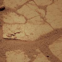
|
Posted by: jamescanvin Aug 6 2010, 07:27 AM
Looks like ~76m by the tracking data - 70m blind 6-7m autonav.
Not quite the 20m of autonav we were expecting and it looks like only ~1.5 hours of driving not the 3 that Scott tweeted that they had. I look forward to news/images...
Posted by: Tesheiner Aug 6 2010, 07:49 AM
Here's the fhazcam image with the 15deg. turns left/right clearly visible.
http://qt.exploratorium.edu/mars/opportunity/forward_hazcam/2010-08-06/1F334326160EFFAMOVP1205L0M1.JPG
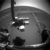
Posted by: Stu Aug 6 2010, 08:23 AM
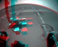
|
C'mon baby, do the Maxwell Motion...
Posted by: Tesheiner Aug 6 2010, 09:02 AM
Today's navcam mosaic.
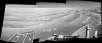
|
Posted by: fredk Aug 6 2010, 09:54 PM
Some details on the driving from http://twitter.com/marsroverdriver/status/20479537579 and http://twitter.com/marsroverdriver/status/20479687539
Powered by Invision Power Board (http://www.invisionboard.com)
© Invision Power Services (http://www.invisionpower.com)