Printable Version of Topic
Click here to view this topic in its original format
Unmanned Spaceflight.com _ Opportunity _ Post Block Island Meteor Studies (The Western Route)
Posted by: Bobby Sep 13 2009, 09:58 AM
I think it's time for a new thread for Opportunity after her Block Island Studies and time to think about where
the Mars Rover Drivers are going to send Her. Will they decide to head south of Block Island or go back
to the western route they were on before?
Where ever they go. I hope they find some more interesting surprises along the way.
One Question I do have regarding the Rovers. Have they ever found any Diamonds or Gold along the way
and if mars did have them. Would they be buried beneath the surface??? Something I've been wondering
about for a while if any precious metals would be on Mars or Not? I would say yes.
Time to start 
Posted by: Stu Sep 13 2009, 10:14 AM
Patience, young Jedi, still a few things to see here I think. She'll roll on when she's ready! 
Posted by: Tesheiner Sep 13 2009, 10:34 AM
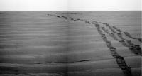
Actually she is. Opportunity left the area today, sol 2004, with a 70m drive; first N and then NW in the general direction of the previous western path.
We're on the road again!
|
(This is a preview. I'll post a map update later on in the proper thread when the images are downlinked)
Posted by: Stu Sep 13 2009, 11:03 AM
Ah, I'd missed that. My apologies, Bobby; I honestly thought we'd spend a couple of sols looking at the bits of darker material scattered around BI. Well... Onwards it is then!
( A look back at the "http://roadtoendeavour.wordpress.com/2009/09/13/oppys-2009-tour-of-block-island" on my "Road To Endeavour" blog, if anyone wants a look. )
Posted by: BrianL Sep 13 2009, 03:57 PM

I agree, as long as they find them roving along the rim of Endeavour.

As a great man once said, drive drive drive!
Posted by: Ant103 Sep 14 2009, 05:43 PM
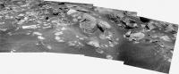
The Sol 2004 drive direction pan in color R1&R2
http://www.astrosurf.com/merimages/Opportunity/2009/Sol2004-pancam.jpg
Posted by: HughFromAlice Sep 14 2009, 07:51 PM
Nice one, Ant!! If this were YouTube I'd give it ***** !!
Posted by: Tesheiner Sep 14 2009, 10:37 PM
I'll second that. The wheel tracks from the out and inbound legs are clearly visible on the mosaic.
Today is another driving sol. My take is that we'll catch that path and continue WNW until the same or similar point as during sol 1950, stopping for a quick science stop at those two craters Kaiko and Dolphin/Nereus.
Incidentally, I'm not really sure about the name of that second crater. The name "Dolphin" comes from the sequence used to shot the crater's pancam mosaic during sol 1950. However, it is named as "Nereus" on the monthly report from July. I'm tempted to take the second one as the correct one but it would be great if someone could confirm it.
Posted by: jamescanvin Sep 15 2009, 08:05 AM
Here are my recent drive direction mosaics:
2002
http://www.nivnac.co.uk/mer/index.php/dd-2002
and 2004
http://www.nivnac.co.uk/mer/index.php/dd-2002
Both link to the same page.
James
Posted by: Tesheiner Sep 15 2009, 01:51 PM
Navcam images from sol 2006 after yet another 70m drive available here: http://qt.exploratorium.edu/mars/opportunity/navcam/2009-09-15/
Wait! What's this, we're not alone; two more rovers are around here! 

|
Posted by: Juramike Sep 15 2009, 03:05 PM
Shouldn't we be on the other side of the highway? Or are we using British driving conventions?
(So was Block Island just a roundabout?)
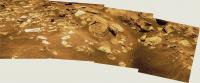
Posted by: Ant103 Sep 15 2009, 04:26 PM
My version of the Sol 2006 pan :
http://www.astrosurf.com/merimages/Opportunity/2009/Sol2006-pano.jpg
And just for the fun, a rectilinear version 
ps : HughFromAlice, thanks .

|
Posted by: brellis Sep 15 2009, 07:54 PM
So much for "the road less traveled", hehee. Roll on, Oppy!
Posted by: climber Sep 15 2009, 08:26 PM
It reminds me of this (from Tintin au pays de l'or noir):

|
Posted by: Phil Stooke Sep 15 2009, 08:37 PM
Hey, wait a minute - Winnie the Pooh did that first...
Phil
Posted by: Ant103 Sep 16 2009, 02:25 PM
Sol 2007 navcam drive direction
http://www.astrosurf.com/merimages/Opportunity/2009/Sol2007-pano.jpg
Posted by: djellison Sep 16 2009, 02:54 PM
All these tracks remind me of the time up near Larrys Lookout where we did the U-Turn and ended up with three sets of near parallel tracks
Posted by: Ron Hobbs Sep 16 2009, 10:09 PM
According to the Mars Exploration Rover calendar, tosol is Opportunity's 3rd Martian Birthday. Did anyone do a cake? I am speaking at the Seattle Astronomical Society and we will sing Happy Birthday.
Posted by: elakdawalla Sep 16 2009, 11:49 PM
Egads! Almost forgot. Thank you for the reminder. Duly Tweeted
--Emily
Posted by: Joffan Sep 17 2009, 02:07 AM
I hope that you sing Happy Birthsol ...

Posted by: djellison Sep 17 2009, 06:46 AM
Nope - but UMSF, as ever, sent Birthday Cards to Cornell and JPL.
Posted by: climber Sep 17 2009, 07:58 PM
Is there a place where I can se what I, I mean we sent?
Posted by: HughFromAlice Sep 17 2009, 08:23 PM
Quick bit of before work fun - stitch and enhancement of pancam pics just down from Sol 2006 (earth time 15 Sep) - I'm a sucker for tracks..... especially doubles.
|
Posted by: djellison Sep 17 2009, 09:43 PM
Because I'm a total genius who basically FORGOT to send cards in time for Spirit's 3rd - so I rushed it and didn't take pictures before I sent them. They had big fluffy blue monsters on them
Posted by: Ant103 Sep 17 2009, 10:45 PM
Very nice one HughFromAlice
I also discovered that this is a color panoramic. So :
http://www.astrosurf.com/merimages/Opportunity/2009/Sol2006-pancam.jpg
Posted by: HughFromAlice Sep 18 2009, 03:52 PM
Thanks Ant! Having fun learning from you guys!! I 've just done a small colourized dust devil movie in the Spirit West Valley thread.
Posted by: Stu Sep 18 2009, 10:09 PM
Interesting area, this...
|
|
Posted by: stewjack Sep 19 2009, 01:48 AM
VIRGIN VISTAS AGAIN -
Jack
Posted by: Bill Sep 19 2009, 08:14 AM
Does anybody understand something about the name of the craters here ?
For tosol they plan :
02010 p2410.20 0 0 0 0 0 0 pancam_Nereus_11x2_L257R2
02010 p2559.23 0 0 0 0 0 0 pancam_Nereus_ejecta_L234567Rall
Is Nereus the new name of Dolphin or the name of the next small crater on the way ? 
Posted by: brellis Sep 19 2009, 03:57 PM
Regarding the color panoramic in Ant's post 25, what causes the dark marks along the path? Does the rover stop at regular intervals during a drive? How does that work with the auto-nav update?
Apologies as I presume this has been answered, but my searches don't lead me to it.
Posted by: Tesheiner Sep 19 2009, 04:15 PM
For tosol they plan :
02010 p2410.20 0 0 0 0 0 0 pancam_Nereus_11x2_L257R2
02010 p2559.23 0 0 0 0 0 0 pancam_Nereus_ejecta_L234567Rall
Is Nereus the new name of Dolphin or the name of the next small crater on the way ?
The former. It answers http://www.unmannedspaceflight.com/index.php?showtopic=6204&view=findpost&p=146138.
Apologies as I presume this has been answered, but my searches don't lead me to it.
The marks come from the wheels' surface which is not uniform. Let's see if I can find a picture...
Posted by: Stu Sep 19 2009, 05:02 PM
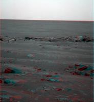
Some lovely blocks around the edge of the latest crater in Oppy's tour...
http://twitpic.com/ibf9b
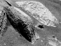
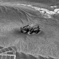
Posted by: CosmicRocker Sep 20 2009, 04:40 AM
http://marsrovers.jpl.nasa.gov/gallery/all/1/f/1137/1F229125161EFF81HQP1201L0M1.JPG is probably a good example. Each wheel's tread pattern contains what has sometimes been called a "star pattern." It occurs once on each wheel's circumference and serves to punctuate what would otherwise be monotonous and mostly featureless tracks in the soil. The patterns create repetitive features in the rover's wheel tracks that are useful for auto-navigation and other functions.
Posted by: djellison Sep 20 2009, 07:16 AM
The star patttern isn't there for fun though, it's where the wheels were bolted down onto the lander deck for launch, cruise and landing.
Posted by: HughFromAlice Sep 20 2009, 11:48 AM
Interesting rocks - so here's a b/w stitch of 4 left pancam images Sol 2010. Enhanced the originals to bring out as much detail as I could, although posted here at 15% below full res to get under the 1 Meg limit.
They've all been taken through basically the same filter (754/3nm - red) - so haven't gone beyond black and white. Hope jpegs taken through other filters are available soon as this set would be good fun to make a colour pic out of.
|
Posted by: Stu Sep 20 2009, 11:59 AM
Definitely not a "rock garden" to wander into...

|
Fascinating geology here tho...
Posted by: HughFromAlice Sep 20 2009, 02:03 PM
Decided to colourize it anyway - sort of how I imagine it might look! If I had a bit more time I would get rid of the white areas on the rocks as they should be coloured.
|
Stu - loved your anaglyph..... as always! You wouldn't want to be wandering around in your spacesuit amongst that lot during the night without a really good torch! (Rip -
 )
)
Posted by: dvandorn Sep 20 2009, 04:05 PM
Hmmm... not only are there two specific types of rocks in the B&W images, one appearing white and the other appearing darker gray, there are several rocks in the image which show both rock types within the same rock. You can see in several rocks a contact between the light and darker rock types. And in a couple of cases, the faces are oriented exactly the same on both sides of the contact, so this can't just be an artifact of illumination angle.
I will say that there seems to be absolutely no difference in how the two different types of rocks have weathered -- i.e., those rocks which exhibit contacts don't exhibit weathering differences on the different sides of the contacts. So, whatever is causing the albedo difference is not changing the overall softness of the rocks.
I'd have to think this shows some form of compositional change. This is the first place in a while where I wish the APXS and the Mossbauer were still working as quickly as they did a couple of years ago...
-the other Doug
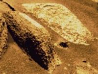
Posted by: HughFromAlice Sep 20 2009, 10:44 PM
You've made an interesting point Doug. It was this sort of rock that made me think that the whiteness was probably due to an artifact of camera exposure or illumination. (Plus I only know a very little about geology!)
1 -

|
But when I relook at things in the light of your comments and come across this ... the white area on the top of the taller rock in the front
2 -
|
|
then I get what you mean. The slab behind it...... does it look to you as if it could be made up of two different rock types?
It is certainly an interesting place. It would have been great to stop, but having just been to Teishner's lastest map, it looks as if Sol 2011 may have taken us past here.
Posted by: Juramike Sep 20 2009, 11:51 PM
I'm not sure, but I strongly suspect it might be an effect of sun angle glinting off flat surfaces of the rock.
(The shadows indicate we are looking close to the direction of the sun.)
It'd be neat if there were observations done at a different time....(are there?)
Posted by: serpens Sep 21 2009, 04:51 AM
I don't see any difference other than angle of illumination. if it was indeed a compositional change then it should be evident in the side of the rock closest to us.
Posted by: Stu Sep 21 2009, 05:58 AM
3d view...
|
Posted by: Ant103 Sep 21 2009, 07:44 AM
The Sol 2010 panoramic view :
http://www.astrosurf.com/merimages/Opportunity/2009/Sol2010-pancam.jpg
Posted by: RobertEB Sep 21 2009, 01:08 PM
Quote removed - Mod
The rocks look like they are full of blueberries. I wish they could take a closer look at those layered rocks.
Posted by: Airbag Sep 21 2009, 05:56 PM
I can personally vouch for the fact that the 3rd anniversary card enjoys pride of place in the middle of the table in one of the Ops rooms in Cornell.
And many of you will like this - overheard during last Monday's Opportunity SOWG: "Drive, baby, drive!".
All systems normal (including that one wheel's motor current) except for the mini-TESS' still present dust layer of course. They will leave the aperture open and hope to just get lucky one day with the wind coming from *just* the right direction to blow at least some of the dust off the mirror. Batteries also in great shape still.
Expect plenty more Westward travel before turning South, but that is not a surprise of course.
Airbag
Posted by: jamescanvin Sep 21 2009, 07:36 PM
Recent Drive Direction mosaics:
2006
http://www.nivnac.co.uk/mer/index.php/dd-2006
2007
http://www.nivnac.co.uk/mer/index.php/dd-2006
2009
http://www.nivnac.co.uk/mer/index.php/dd-2006
All images link to the same page.
James
Posted by: HughFromAlice Sep 21 2009, 08:06 PM
Really nice !!!
Posted by: phase4 Sep 21 2009, 10:07 PM
Absolutely delicious. Thank you!
Posted by: dburt Sep 22 2009, 01:16 AM
Agree completely, and congratulations to the posters of the panoramas. "Berry nice" views of abundant spherules in the dug-up boulders! As usual, but not usually so clearly seen in images, the spherules are strictly size limited, not clumped together, and occur along (are apparently controlled by) bedding planes. Well worth a closer look, because these features are NOT typical of sedimentary concretions.
-- HDP Don
Posted by: Ant103 Sep 22 2009, 02:49 PM
Very nice views James
Here is the Navcam view of Sol 2011 showing the Nereus -- Nautilus crater. Anaglyph view at the right (Stu, if you read me  )
)
http://www.astrosurf.com/merimages/opportunity-2009.html#last
Posted by: Nirgal Sep 22 2009, 03:05 PM
Excellent work !
The 2007 view in particular is phantastic (one of the best meridiani vistas so far)
Posted by: Oersted Sep 22 2009, 04:32 PM
Oh, but the undulating tracks in "2006".... - Lovely! She's really chugging along over the waves like a little fishing-boat off the Grand Banks!
Posted by: PhilCo126 Sep 22 2009, 04:48 PM
Oppy's tracks in those (superb) mosaics really look like driving ontop of very wet sand... or wet clay
Posted by: Tesheiner Sep 22 2009, 07:30 PM
Good job. I tried that one with autostitch but the results were only regular.
One comment / correction: That mosaic was taken "mid-drive" during sol 2011 and the crater is not Nereus but actually Nautilus. A similar mosaic was also shot at the same position but with the pancam.
02011::p1713::03::6::0::0::6::0::12::navcam_3x1_az_198_3_bpp
02011::p2411::20::36::0::0::36::2::74::pancam_Nautilus_9x1_L257R2
Posted by: jamescanvin Sep 22 2009, 08:16 PM
Thanks for all the nice comments. Here is a quick go at the sol 2011 drive direction mosaic.
http://www.nivnac.co.uk/mer/index.php/dd-2011
James
Posted by: dburt Sep 22 2009, 11:16 PM
Agreed and a good observation. As has been noted previously, the apparent particle cohesion is most likely caused by a high content of salts that have sucked enough moisture out of their environment to render them sticky. Low temperatures favor the accumulation of moisture by hygroscopic or deliquescent salts. Wicking and evaporation of condensed moisture towards the surface could increase the salt content there (the duricrust hypothesis that dates from Viking lander days). The surface looks "wet" when it is actually salty, cold, and just a tiny bit moist (owing to the salts). Or at least that's one explanation.
-- HDP Don
Posted by: serpens Sep 23 2009, 04:40 AM
Actually the tracks don't look significantly different to the Apollo rover tracks.
Posted by: Phil Stooke Sep 23 2009, 11:19 AM
Any stickiness would result in the wheels getting thickly coated with the damp regolith. It would be apparent immediately, and would have become a major problem from sol 1 on. The tracks look much more like impressions in fine dry powder - like lunar tracks as serpens said. But it's the behavior of the dust on the wheels that clinch it - it cakes on and then falls off, it doesn't really stick.
Phil
Posted by: Tesheiner Sep 23 2009, 08:02 PM
Today, sol 2014, was once again dedicated for driving. About 60m were added to the odometer.
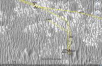
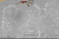
Here's a snapshot from Google Mars with our current position, based only in the mobility data while today's images don't hit the exploratorium. Opportunity is about 100m (two driving sols) from reaching a very big patch of bedrock which will probably be our "yellow brick road" for the next month or so.
Check the KML file in the http://www.unmannedspaceflight.com/index.php?showtopic=681&view=findpost&p=146625 and don't forget to download http://www.unmannedspaceflight.com/index.php?showtopic=5476&view=findpost&p=142132 to see the background map to the west.

|
Edit: added a link to the map extensions.
Posted by: dburt Sep 24 2009, 12:38 AM
Phil and Serpens - Thanks for your insights. Your logic apears excellent, although "damp" might be completely the wrong word here (i.e., for a molecule-scale coating of polar water molecules on top of unsatisfied ionic bonds), and weak self-adhesion of dust particles, allowing the development of "wet-appearing" vertical walls in ruts, isn't the same as strong bulk adhesion to a vibrating foreign object such as a moving wheel. Utter lack of personal experience dealing with martian conditions (very fine cold heterogeneous salty dust in a near vacuum in a weak gravity field) may have led me, and possibly you also, astray. Terrestrial experience (thick, moist, warm atmosphere, little day-night temperature difference, clay-dominated dust particles or rounded quartz sand, few salts, strong gravity field) could be misleading in dealing with Martian conditions. Lunar experience (perfect vacuum; hot dry angular salt-free glassy agglutinate particles) could also be misleading in this regard.
Bottom line: I don't know who is right, possibly none of us, but I'd be wary of either terrestrial or lunar analogs.
-- HDP Don
Posted by: alan Sep 24 2009, 05:58 AM
The circled crater looks young. Perhaps it will be the next stop.
|
Posted by: Tesheiner Sep 24 2009, 10:43 AM
Yeah, I think you are right.
Speaking of craters, I saw that today's imaging plan has a sequence to take a pancam shot of a crater named "Gjoa". I believe it is this tiny little crater right beside the rover's position on sol 2014.
|
After searching for its meaning I found this: http://en.wikipedia.org/wiki/Gjøa.
"Gjøa was the first vessel to transit the Northwest Passage. With a crew of six, Roald Amundsen traversed the passage in a three year journey, finishing in 1906."
Really nice name selection, isn't it?
Posted by: PaulM Sep 24 2009, 11:59 AM
Block Island was visible in a HIRise photo. Large slabs of bedrock are often visible on HIRise photos. However, the only distinct rock that I remember seeing on the open plains was Block Island. What I wondered is whether all distinct visible rocks on the open plains in HIRise photos are meteorites?
I wonder whether it would be worth searching for similar distinct rocks on HIRise photos over Oppy's entire projected route to Endeavour Crater?
If we found such a rock then we could suggest a deviations of a few 100m to the left or the right to investigate that promising looking rock.
Posted by: RobertEB Sep 24 2009, 01:45 PM

I see 3 dimples in this shot. I am guessing those are tiny craters. I would like to the them look at one with the Microscopic Imager.
http://marsrovers.jpl.nasa.gov/gallery/all/1/n/2013/1N306890954EFFA6NEP0743L0M1.HTML
Posted by: ElkGroveDan Sep 24 2009, 01:48 PM
|
|
Bang my head moment here, but in my view from Google Mars the HIRISE image ends before this point Alan. Did you do your own overlay? OR am I doing something wrong here?
Posted by: jamescanvin Sep 24 2009, 03:07 PM
http://www.unmannedspaceflight.com/index.php?s=&showtopic=5476&view=findpost&p=142132
EDIT:
Oops, Thanks Tesheiner (below) for correcting the link (now fixed)
I was being lazy and just copied what was in my browser rather than clicking on the post number to get the link. As I have the the board set to display 40 posts per page it wouldn't have worked for those set to only show 10 per page.
Posted by: Tesheiner Sep 24 2009, 03:22 PM
James, thanks for finding the post but the link above points to two pages before, at least on my browser. This one goes directly to it: http://www.unmannedspaceflight.com/index.php?showtopic=5476&view=findpost&p=142132
(BTW, I should better add the link to my previous post on this thread.)
Posted by: marsophile Sep 24 2009, 03:38 PM
I wonder whether it would be worth searching for similar distinct rocks on HIRise photos over Oppy's entire projected route to Endeavour Crater?
It might be worth equipping future rovers with an instrument for accurately dating meteorites from their isotope ratios. If meteorites are common on the Martian surface, that might serve to constrain the age of the terrain and the rate of erosion. Perhaps an enhanced version of the APXS could have that capability.
Posted by: ElkGroveDan Sep 24 2009, 04:09 PM
Thanks James. I knew it had to be something like that.
Posted by: Vultur Sep 24 2009, 05:06 PM
What is the scale on that image: how big is Gjoa?
Posted by: Poolio Sep 24 2009, 06:19 PM
Looks to be about 4m across.
Posted by: Tesheiner Sep 24 2009, 08:07 PM
It's partially visible on this image: http://qt.exploratorium.edu/mars/opportunity/navcam/2009-09-24/1N306979102EFFA6U9P1861L0M1.JPG
Now, it's 70m behind the current position.
Posted by: djellison Sep 24 2009, 08:51 PM
We're almost 500m west of Block Island already.
Posted by: BrianL Sep 25 2009, 04:25 AM
Indeed, at this pace, we could be at Endeavour in a year and a half (or so, I'm not claiming precise arithmetic here). Wishful thinking, perhaps, but I am loving the current commitment to drive, drive, drive. Keeping my fingers crossed that they have truly figured out the key to keeping the RF wheel happy without delaying rest stops.
Posted by: climber Sep 25 2009, 05:39 AM
It'll become even better for RF in a few more meters when we'll hit the hard ground
Posted by: Tesheiner Sep 25 2009, 07:21 AM
Let's see if we have any hint of information about the currents in the next official status report.
Meanwhile, just say that I believe Opportunity will stop here for the weekend; there are some MIs planned for tosol so guess the next move may be on saturday or sunday.
Posted by: Tesheiner Sep 25 2009, 02:58 PM
From the current status report:
As of Sol 2014 ... Total odometry is 17,717.33 meters (11.01 miles).]
Posted by: Tesheiner Sep 26 2009, 08:21 PM
Here's the navcam mosaic taken during sol 2017 and pointing towards SW.

|
Posted by: Bill Sep 26 2009, 08:28 PM
New intersting rock ahead ? After the next drive, we will not be very far. The rock is near the horizon at right on this navcam.
http://qt.exploratorium.edu/mars/opportunity/navcam/2009-09-26/1N307247843EFFA6%23%23P0733L0M1.JPG
Waiting for pancam.
Posted by: CosmicRocker Sep 27 2009, 03:48 AM
Does anyone have any thoughts about the http://marsrovers.jpl.nasa.gov/gallery/all/1/m/2016/1M307156367EFFA63QP2956M2M1.HTML that came down from sol 2016? A http://marsrovers.jpl.nasa.gov/gallery/all/1/f/2016/1F307156625EFFA63QP1110L0M1.HTML from the same sol shows the dusty MI pointed toward what I am guessing is the shoulder elevation actuator of the IDD. I am not sure that is what it is, but it's my best guess after comparing the images to a drawing and a model of the rover.
I wonder what they may be looking for.
Posted by: Astro0 Sep 27 2009, 11:23 AM
Yes, interesting....???? 

|
Problem? Pointing error? Test for Spirit's "Matrix-move"? Hmmm?
Maybe they're thinking about Doug's suggested MI self-portrait.
Posted by: jamescanvin Sep 27 2009, 06:10 PM
I few more small mosaics. Drive directions from sols 2013, 2014 & 2015 and Gjøa Crater.
All the thumbs link to the same blog entry.
2013
http://www.nivnac.co.uk/mer/index.php/2013_dd
2014
http://www.nivnac.co.uk/mer/index.php/2013_dd
2015
http://www.nivnac.co.uk/mer/index.php/2013_dd
Gjøa Crater
http://www.nivnac.co.uk/mer/index.php/2013_dd
James
Posted by: Stu Sep 27 2009, 08:20 PM
Rubble pile up ahead (is that what you meant Bill?), with another possible BI beyond it..?

|
Posted by: Tesheiner Sep 27 2009, 09:04 PM
Mmm, this rubble pile is exactly on our way. Guess we'll do a little pit stop there. My 2c.
Posted by: Ant103 Sep 28 2009, 05:27 PM
Gjøa Crater (what a strange name
Scandinavian for sure, no?) on Sol 2015 :
http://www.astrosurf.com/merimages/opportunity-2009.html#last
Navcam panorama of Sol 2017 :
http://www.astrosurf.com/merimages/opportunity-2009.html#last
Posted by: ilbasso Sep 28 2009, 06:19 PM
The wise guy who put electrical tape over the instrument!
Posted by: nprev Sep 28 2009, 06:53 PM
...which of course leads to the question I've been afraid to ask, to wit: What the hell IS that thing? Been assuming that it's part of the descent stage release mechanism or some other such system that's long since fulfilled its purpose.
Posted by: Airbag Sep 28 2009, 07:39 PM
It looks to me like the shoulder altitude drive based on:
1) It is covered in tape (so that limits it to http://en.wikipedia.org/wiki/Kapton? covered yellow/brown objects)
2) The geometry - I think that is the base of the IDD shoulder support in the background, looking at it from slightly below.
So I think it is the horizontal brown cylinder that is just left of center in:
Airbag
Posted by: Bill Sep 28 2009, 08:39 PM
Yes this one. Attractive isn't it ? New heaven's gift or classic ejecta from the nearby crater ?
Next stop we will know (if we stop!).
Posted by: Patteroast Sep 28 2009, 10:46 PM
Gjøa was the name of the ship that Norwegian explorer Roald Amundsen used to make the first voyage through the fabled Northwest Passage in the Canadian far north. There's still a town named after it up there where he wintered, 'Gjoa Haven'. A few years later he led the first successful expedition to the South Pole. So in short, it's named after a ship of discovery.
Back to our scheduled programming...
Posted by: nprev Sep 29 2009, 10:59 AM
Ah. Thanks, Airbag; that looks like a pretty good candidate!
Posted by: fredk Sep 29 2009, 09:15 PM
It looks like we sailed past the rubble pile on sol 2020:
http://qt.exploratorium.edu/mars/opportunity/forward_hazcam/2009-09-29/1F307511550EFFA6%23%23P1201L0M1.JPG
but the rock still could be a target:
http://qt.exploratorium.edu/mars/opportunity/navcam/2009-09-29/1N307512761EFFA700P0753L0M1.JPG
It's certainly reminiscent of BI:
http://marsrovers.jpl.nasa.gov/gallery/all/1/n/1957/1N301920678EFFA500P1985R0M1.JPG
but we'll need closer pancam views before we can utter the "M" word again...
Posted by: Stu Sep 29 2009, 09:52 PM
Hmmm... it's a meteormight...
Posted by: Juramike Sep 29 2009, 09:57 PM
That's an interesting big dark area up on top. Mebbe a big 'ol cavity?
Posted by: Astro0 Sep 29 2009, 11:08 PM
Sure looks like another Block Island...

|
Wait a minute! That is Block Island...we've been going around in circles!!!!
OR maybe it's following us

Posted by: fredk Sep 30 2009, 02:07 AM
Pancams are down:
http://qt.exploratorium.edu/mars/opportunity/pancam/2009-09-29/1P307513900EFFA700P2418R1M1.JPG
I think we're starting to see cavities... Anyone able to spot it on the full-res hirise images? It does look somewhat smaller than BI.
Posted by: Astro0 Sep 30 2009, 02:15 AM

|
Posted by: nprev Sep 30 2009, 02:28 AM
The plot thickens, much like fusion crust on the right....?
Posted by: PDP8E Sep 30 2009, 02:45 AM
I processed the 'block'...and it looks like a RHINO
The cavities, etc. scream iron meteorite, but we shall see!
cheers
Posted by: Phil Stooke Sep 30 2009, 02:58 AM
Oh no - this better not be another interesting rock, I want to drive!
Phil
Posted by: eoincampbell Sep 30 2009, 04:28 AM
Brilliant, I love this vehicle...
Posted by: Stu Sep 30 2009, 06:00 AM
3D view here...
http://twitpic.com/joxyf/full
Posted by: Tman Sep 30 2009, 06:04 AM
Oppy has become an expert in the matter of meteorites - the "expertises" should go faster now...
It's like the first gold seekers that found a good place here. All over the place a big nugget direct on the surface.
Posted by: MizarKey Sep 30 2009, 06:55 AM
It's beginning to feel like Antarctica, big flat plain like a meteorite magnet. Could be more for the same fall that produced BI?
Posted by: vikingmars Sep 30 2009, 08:27 AM
Yes ! Phil is damn right. We should stay on the "Follow the Water" trail , NOT embark ourselves on a "Follow the Iron" quest.BIG discoveries are yet to be made at Endeavour crater : olivine, philosilicates, pyroxene, clays... maybe. Please, don't stop at every rock : let's drive !
Posted by: Stu Sep 30 2009, 08:53 AM
Awww, a quick look won't hurt guys Driving is good, and amazing discoveries await us at Endeavour, but looking at any meteorites we find along the way is a good idea because that will tell us a lot about the past of this fascinating area - how the landscape has changed over time, weathering effects here, etc.
And come on... meteorites... ancient, gnarled, radiation-soaked chunks of metal and iron sharpnel from space... sitting on the surface of Mars... right in the path of one of the most amazing spacecraft ever designed, built and sent to another world...
To not stop and pay our respects would be just rude
Posted by: djellison Sep 30 2009, 10:55 AM
A quick stop - image it, and drive on. That's about as much as I could probably handle
Posted by: Tesheiner Sep 30 2009, 01:34 PM
I would expect it'll be the focus of this weekend's stop.
Posted by: climber Sep 30 2009, 02:45 PM
I was sure you'll answer this, Eduardo!... and it makes sense to me... as well as to RF
But I'd better like Doug's idea of a kind of "Touch & Go".
Posted by: Juramike Sep 30 2009, 03:01 PM
You're only here for a short visit. Don't hurry, don't worry. And be sure to smell the flowers along the way.
-golfer Walter Hagen
Posted by: Ant103 Sep 30 2009, 03:23 PM
The complete panoramic of Nereus on Sol 2010 is done (pancam R2) :
http://www.astrosurf.com/merimages/opportunity-2009.html#Sol2010
Posted by: ustrax Sep 30 2009, 04:30 PM
Trying not to forget that what is important is the journey but...come on guys!
I've already run out of map...and we're almost three months behind schedule...

|
Posted by: climber Sep 30 2009, 08:54 PM
OK but we already scored an Eagle at the first shot.So,
Posted by: HughFromAlice Sep 30 2009, 09:29 PM
Very witty!!!!! So, was Block Island a 5 iron or 6 iron? (OK, I deserve a kick in the pants for that one!).
Posted by: Oersted Sep 30 2009, 09:47 PM
This mission has proved to be very much about the voyage itself and not a particular end goal. There won't be too much of value to stop for on these deserted plains, I say, let's pause and take a look. For a rover that has lasted or years, and seems good to go for much longer, one day more or less won't mean a lot.
Posted by: BrianL Sep 30 2009, 10:04 PM
I think this would be an appropriate amount of time to spend at it.
http://www.youtube.com/watch?v=BQJH5tZLGis
Posted by: centsworth_II Sep 30 2009, 11:16 PM
Posted by: JayB Oct 1 2009, 04:23 AM
So you're saying we should rename Endeavour to Walley World?

of course maybe we'll get a feature called Griswold at some point...he was a great explorer and the Family Truckster...now that was a fine ship of exploration
well in case any one wants my opinion (and I know no one does)
Posted by: climber Oct 1 2009, 05:18 AM
So, was Block Island a 5 iron or 6 iron? (OK, I deserve a kick in the pants for that one!).Would nprev have put up this question, I'd had replied: it's just iron, nick (ok these one is worse than yours HughFromAlice..)
Posted by: nprev Oct 1 2009, 05:51 AM
Oh, God, that was foul, Climber!
(I knew I'd get dragged into this somehow...  )
)
Posted by: CosmicRocker Oct 1 2009, 06:26 AM
This new rock seems like it just might be large enough and have enough contrast to be visible to the HiRise camera. There does seem to be a bit of a dark smudge near where I am guessing the rock is sitting.

|
Regarding how long Opportunity may stop to study this rock, perhaps only in passing. The pancam tracking database indicates images will be taken of "Falcon Crater" on sol 2022, which is tosol. The next apparent craters I can see are about 200 meters beyond the sol 2020 position, suggesting the rover is already long past this new rock. (unless plans have changed)
Posted by: ustrax Oct 1 2009, 11:12 AM
Don't tell me we have another one...
http://qt.exploratorium.edu/mars/opportunity/pancam/2009-10-01/1P307514406EFFA700P2418L6M1.JPG
Posted by: Stu Oct 1 2009, 11:19 AM
This is seriously starting to look like a meteorite "strewnfield", and is reminding me a lot of the "Imilac" fall in Chile's Atacama desert. I'll bet this area is a veritable meteorite garden. What I'd give to be able to wander around here for a sol... I'd be able to add some very impressive specimens to my modest collection...
http://oauniverse.wordpress.com/the-meteorites
Posted by: HughFromAlice Oct 1 2009, 11:35 AM
Rough Nav cam stitch Sol2020 - latest pics from Exploratorium. At least they give a bit of a feeling of orientation and space. It'll be a fair job to stitch these together manually as there seem to be quite large mismatches and distortions between the images.
Looks like an interesting rock in the far right frame - mid distance about 1 o'clock from centre of frame!!! In fact, I am just wondering with all of these, if each of them might not be 'a chip off the same block' (no pun intended, really). But really interesting just the same.

|
Posted by: Poolio Oct 1 2009, 01:51 PM
Could http://qt.exploratorium.edu/mars/opportunity/navcam/2009-10-01/1N307513289EFFA700P1957L0M1.JPG be Falcon Crater?
Posted by: Julius Oct 1 2009, 03:14 PM
dont know why we're driving the other way opposite to where we're supposed to go!dont believe opportunity has problems with its wheel.Anyone explain whats happening?
Posted by: elakdawalla Oct 1 2009, 03:20 PM
The western leg of this jaunt gets them to much better driving conditions (witness the increase in bedrock we're seeing now) and avoids a large field of Purgatory-type dunes that lies on the direct path to Endeavour.
Posted by: fredk Oct 1 2009, 03:30 PM
That's what we'd been calling the "rubble pile" recently in this thread.
Hugh - that's the first of the two new rocks we've been watching for a few sols.
Posted by: Poolio Oct 1 2009, 04:07 PM
Aha, so it is.
I didn't recognize that the http://qt.exploratorium.edu/mars/opportunity/navcam/2009-10-01/1N307513289EFFA700P1957L0M1.JPG image was the same view as the http://qt.exploratorium.edu/mars/opportunity/forward_hazcam/2009-09-29/1F307511550EFFA6%23%23P1201L0M1.JPG referenced earlier. From the hazcam you can't really tell that there's a tiny crater hidden among all that rubble (at least not for these untrained eyes).
Posted by: jamescanvin Oct 1 2009, 06:36 PM
A couple more 'Drive Direction' mosaics
2017
http://www.nivnac.co.uk/mer/index.php/dd-2017
2020
http://www.nivnac.co.uk/mer/index.php/dd-2017
These will probably be my last for a week or two as I'm moving house tomorrow! And will be without my broadband for a while...
James
Posted by: HughFromAlice Oct 1 2009, 08:25 PM
Thanks Fred. What I should have said more explicitly is I was wondering what (if any) the relationship of these rocks might be to Block Island. Interesting that there should be several of them so close together. Are they a group of objects that plunged through the atmosphere all on the same trajectory, bits off 'the old block' that split during atmospheric entry/hitting the ground or is the contiguous location just the outcome of several billion years of chance?
Posted by: centsworth_II Oct 1 2009, 08:39 PM
It seems to me that the landing dates could be millions, or hundreds of millions of years apart and the meteorites are laying on the same surface because either that surface has not changed over that time, or a net removal of surface material has left meteorites that were initially at different levels on the same level.
Posted by: fredk Oct 2 2009, 04:16 AM
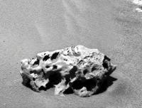
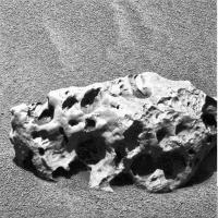
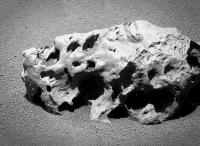
We've arrived at the rock, and oh my, she's a real beauty:
http://qt.exploratorium.edu/mars/opportunity/rear_hazcam/2009-10-01/1R307687342EFFA7AKP1301R0M1.JPG
We need a name for it. Any clues from the pancam database?
Posted by: nprev Oct 2 2009, 04:23 AM
 ...how about "Holy Cow"?
Man, what a beauty!!! Bet my bottom dollar that it's another chunk o' iron/nickel.
Posted by: PDP8E Oct 2 2009, 04:24 AM
Rhino
Posted by: nprev Oct 2 2009, 04:30 AM
Stu's gonna totally lose his mind when he sees this sucker.
Posted by: briv1016 Oct 2 2009, 04:31 AM
Shelter Island
http://qt.exploratorium.edu/mars/opportunity/pancam/2009-10-01/1P307687815EFFA7ARP2562R1M1.JPG
Posted by: Astro0 Oct 2 2009, 04:44 AM
She's a beaut!
|
Combined Pan/Nav cams.
Posted by: CosmicRocker Oct 2 2009, 04:47 AM
Egads! I saw "Shelter Island" listed in the database yesterday, but it didn't register.
Posted by: ElkGroveDan Oct 2 2009, 05:48 AM
Just in time for the season.

|
Posted by: Juramike Oct 2 2009, 05:51 AM
Posted by: Stu Oct 2 2009, 07:21 AM
Wow oh wow... you're right, nprev! Best-looking starstone yet!! (And I'm away from my PC and can't do anything with the images! Curses! ("Hooray!!" shouts everyone else! )
Managed to download Stereo-photomaker to make this tho...

|
Posted by: Tesheiner Oct 2 2009, 04:05 PM
Isn't it a fossilised porcupine?
Posted by: PDP8E Oct 2 2009, 04:54 PM
That's it! I am incorporating... "Martian Iron Works" with headquarters at Meridiani Planum
The raw materials are everywhere: Iron Nickel Meteorites, Hematite (i.e natural ore), red-rust, magnetite, and much more.
My army of hematite gathering rovers and my hordes of magnetic gathering (magnetite) rovers will have cameras -etc for direct download to UMSF. In due time, I will have the Martian Iron and Steel market cornered!
First step: raise $1 trillion USD to get basic infrastructure up and running ... (hmmmm....check back with me later on that one...)
Posted by: fredk Oct 2 2009, 05:24 PM
With the new navcams we can pin down the location of Shelter Island exactly. The feature you indicated with the pink arrow, Rocker, is the curved end of a dune. SI is very close by though, where the green arrow points:

|
(Sorry if I've duplicated your work, Tesheiner, but I haven't installed the GM doohickey yet...)
Posted by: ElkGroveDan Oct 2 2009, 05:37 PM
Good luck with the steel. You'll need a supply of an interstitial element like carbon and unless the rovers start encountering a large number of chondrites, I'm not sure where you'll find that on Mars. If you find some chromium to go with the nickel and iron you'll be able to make stainless steel and there would certainly be a demand for that where structures contact the oxidizing soils.
Posted by: elakdawalla Oct 2 2009, 05:45 PM
Way to be a wet blanket, Dan.
Posted by: ElkGroveDan Oct 2 2009, 06:02 PM
....well then I'll add an upbeat note; From a standpoint of weight and required strength iron will be fine for the kinds of uses we are accustomed to in the lower gravity, and since the atmosphere itself is not highly oxidizing there really won't be a problem with rust on the parts of structures that don't come in contact with the soil. And for those that do, there is an ample supply of silica which could be fabricated into inert vitreous barriers.
So "Martian Ironworks" is probably still a good investment.
Posted by: ngunn Oct 2 2009, 07:17 PM
I don't know. Isn't there quite a lot of carbon in the Martian atmosphere? And since we'll be needing the oxygen as well . . .
Posted by: PDP8E Oct 2 2009, 07:47 PM
Dan, its all taken care of in the 130,000 page business plan.
You know, a Trillion dollars does buy a few contingencies.
So stop worrying and just send me $10 for a share and you are in on the ground floor baby!
Posted by: BrianL Oct 2 2009, 08:21 PM
Don't go for it, Dan. Sure, it's just a trillion dollars now, but give it a few months, and he'll be needing another 100 million for this and 200 million for that. The project time line will get pushed back, and who knows if we'll even still be using iron and steel by the time he's ready to launch. If it was me, I would be looking to invest in an enterprise that looked to Mars as a dumping ground for our excess dihydrogen monoxide. Do you have any idea how many people die each day as a result of contact with this substance?
Posted by: Phil Stooke Oct 2 2009, 09:03 PM
Right, the blasted stuff keeps getting in my Scotch.
Phil
Posted by: Ant103 Oct 2 2009, 10:44 PM
This meteor is pretty sweet . But I hope we will not waste time around this place.
So, here is the Sol 2022 navcam pan centered on Shelter Island :
http://www.astrosurf.com/merimages/Opportunity/2009/Sol2022-pano.jpg
Posted by: eoincampbell Oct 2 2009, 11:25 PM
This is bigger than BI, right ? More than 2X ?
Posted by: fredk Oct 3 2009, 02:52 AM
SI is smaller than BI. There's a little blurb http://marsrovers.jpl.nasa.gov/gallery/press/opportunity/20091002a.html
Posted by: CosmicRocker Oct 3 2009, 03:36 AM
Yeah, 47 cm across for SI versus about 60 for BI.
Thanks, fredk. My guess from the sol 2020 images was a little over 3 meters off. I was planning to refine the location when the navcams came down, so it was nice to see that you had saved me the trouble.
This rock is probably not quite large enough to be resolved, though with its shadow and other local effects, who knows.
Posted by: ElkGroveDan Oct 3 2009, 04:31 AM
Then you're drinking the wrong brand of Scotch.
Posted by: PDP8E Oct 3 2009, 05:15 AM
Here is a processed NAVCAM image of the 'sheltered island' meteorite.
|
let's drive!
cheers
Posted by: PDP8E Oct 3 2009, 06:18 AM
here is a processed PANCAM image of 'sheltered island' meteorite
|
cheers
Posted by: Tman Oct 3 2009, 06:37 AM
. But I hope we will not waste time around this place.So, here is the Sol 2022 navcam pan centered on Shelter Island...
Think so too, because there seems to be at least one more in sight in the upper right of the pan...
http://www.unmannedspaceflight.com/index.php?showtopic=6204&view=findpost&p=147061
Posted by: MarsIsImportant Oct 3 2009, 07:35 AM
SI is partially buried in the dune. If it wasn't for the ripple, it would be on the surface. This makes me wonder what else lurks beneath this wind blown stuff.
Posted by: Stu Oct 3 2009, 08:55 AM
Managed to work on Shelter Island a little more...
|
This is a seriously-beautiful meteorite... if this had been found on Earth it would be a museum centre-piece, with all those features...
Posted by: nprev Oct 3 2009, 09:24 AM
No argument there. Makes me wonder how many great rocks like this have been quickly destroyed (relatively speaking) by Earth's voracious weathering processes.
<shakes fist>WAAAAATERRRR!!!!!....
Posted by: climber Oct 3 2009, 09:44 AM
Do you think of an evident reason why there's "so much" meteroits in this area while none has been noticed since the one near Endurance? (was it Bounce rock?)
Posted by: MarsIsImportant Oct 3 2009, 10:48 AM
Why so many here?
...Perhaps the break up of a larger meteorite. Maybe these are parts of the same single streak in the Martian sky. It might explain why Block Island looks the way it does...the weird looking cavities as if untouched by the forces of atmospheric entry. There are a few small craters that appear relatively young in this part of the plain too. Just food for thought and thinking out loud.
Posted by: centsworth_II Oct 3 2009, 02:38 PM
Heat Shield was the meteorite near Endurance. Bounce was the piece of long-traveled ejecta near Eagle (Opportunity's landing site).
Posted by: centsworth_II Oct 3 2009, 02:47 PM
I see this suggestion a lot, but all the meteors have a rounded, potato-like shape. They seem whole to me, not like a cut up potato. Meridiani is apparently a very old surface which has had millions or billions of years to collect random meteors.
edit: I really don't know a lot about the subject. Have Iron meteors on Earth been known to break up on entry? My impression is that they are pretty solid lumps, not likely to break up.
Posted by: helvick Oct 3 2009, 03:13 PM
I'm with you there - the fact the we're seeing a basketball sized meteorite every couple of km (on average) isn't all that surprising when you think how long a few billion years actually is. I seem to recall reading somewhere that about 10 meteorites are recovered soon after falling on earth every year (as opposed to the total that are found but may have been in situ for a long period of time) . Ignoring scientific rigor for a minute and just thinking about ballpark numbers let's say that this is a reasonable floor level number for the number that reach the surface of Mars intact (since it has a similar land surface area to Earth). Over a billion years we're looking at 10 billion meteorites. The surface area of Mars is about 145m Sq km. It is not unreasonable to expect that each sq km should have about 70 meteorites (on average). Assuming that only about 2-3% are Iron meteorites like Heat-Shield\BI then expecting to find 1-2 per sq km isn't unreasonable. We have a sensor range of around 100m (say 50m each side of the track) where we're likely to be able to see and recognize a large meteorite. With 18km driven we've probably covered about 2 square km of surface at enough detail to be able to see these things and we've found 3 that we're certain of.
Frankly I'm surprised that there aren't many more.
Posted by: antoniseb Oct 3 2009, 04:02 PM
I can imagine that if we see a lot of rounded metal meteorites on the surface, and that they all fit into a narrow size category, that probably tells us that they landed at a time when the ice on the surface was a certain (unknown to me, a hack) thickness that protects these basketball sized rocks, and drops them gently to the surface (maybe millions of years later), but that larger hunks of Iron drill through in the initial event and create craters.
I'm interested in getting to the big crater, but stopping along the way to catalog this hunks of Iron seems smart.
BTW, I wonder if the black rubble piles we've been seeing are also meteors that got their falls broken by ice.
Posted by: centsworth_II Oct 3 2009, 04:16 PM
Do solid chunks of iron really need to be 'protected?' And besides, how much different is it for a meteor to hit ice as opposed to loose regolith or soft rock? I don't see any way to infer that these meteors landed on ice. Isn't the current thinking that they landed at a time when the atmosphere was thicker and slowed them considerably before impact?
Maybe there was ice and maybe not. I just don't see it as being necessary [or even indicated] to explain the current situation.
Posted by: helvick Oct 3 2009, 04:41 PM
While there are obvious differences in the nature of an impact into ice, sand, soft or hard rocks I suspect that only impacts into hard rock noticeably affects the initial survivability of the meteorites. Landing in ice and becoming embedded protects meteorites on earth (I think) because we have an extremely dynamic surface environment but on Mars I suspect that simply being exposed on the surface is a far more benign long term environment - the internal mechanics of ice sheets over geologic time scales are pretty brutal after all.
Posted by: nprev Oct 3 2009, 06:31 PM
I would think that the density of the atmosphere would be a far greater determinant for meteorite EDL survival since that largely determines terminal impact velocity for objects of this size. IIRC, there were a few rather offhand comments on the JPL site speculating that the atmosphere must have been significantly thicker when BI hit.
Bottom line: These guys are probably really, really old & they're being slowly exhumed (& reburied) as the dunes move around.
Posted by: ElkGroveDan Oct 3 2009, 08:48 PM
I love your line of reasoning Joe, and I think you are spot on. What might add to the unexplained gap is the sand dunes. Objects the size of Block Island and Sheltered Island, being a significant portion of the size of the local dunes, are probably big enough to interfere with the air flow and sand movement and thus are probably always visible. Smaller objects like Heat Shield Rock, and smaller may in fact have a chance of becoming buried by the migrating sands, or might even be just out of view behind a dune. As it is Block Island is approaching the limits of observability from HIRISE. And that doesn't even take into account the survivability of a less stable meteorite like a chondrite. What might one of those look like after thousands or millions of years (cobbles?)
I suspect that there are many more meteorites at Meridiani that a six foot tall person trudging back and forth across Meridiani might easily spot or uncover with a few kicks in the sand.. And if you go back over the HIRISE images at random you do see discontinuities in the sand dunes that seem out of place, as well as little smudges and whatnot that could very well be more "Heatshield Rock" sized objects. I would venture that a useful study could be gleaned from a half dozen identical HIRISE images taken under optimum conditions of the known Meridiani environs and stacked for super-res properties. That might provide a chance for a careful inventory and study on the numbers of suspect objects.
Posted by: antoniseb Oct 3 2009, 10:13 PM
Not so much that the hunk of Iron need protecting as Mars does. What size crater would this hunk of Iron have left? That crater isn't evident.
Posted by: Reed Oct 3 2009, 11:36 PM
That's something I've been wondering about. A sample size of three isn't much, but from earth experience there should be dozens of stony meteorites to go with them (assuming they aren't part of a single fall.) Some completely amateur speculation:
- Maybe conditions were such that iron meteorites could survive entry/impact but stony meteorites in the same size range shattered ?
- Maybe they are there, and we are just missing them because they look don't stand out as much. Probably true to some extent, but I don't recall anything block island sized that didn't look like local bedrock.
- Maybe the stony meteorites did survive landing, but erosion or other processes break them more quickly than irons ?
My WAG is mostly a combination of the first two. I did find references to some cobbles being identified as probable meteorites:
http://adsabs.harvard.edu/abs/2006LPI....37.2401J 37th Annual Lunar and Planetary Science Conference, March 13-17, 2006, League City, Texas, abstract no.2401
http://meetingorganizer.copernicus.org/EPSC2009/EPSC2009-512.pdf (pdf) Mars EPSC Abstracts, Vol. 4, EPSC2009-512, 2009
Posted by: alan Oct 4 2009, 02:10 AM
Oppy passed by a couple of potential meteorites shortly before reaching Beagle Crater
This one was listed as genovesa in the database (image from sol 875)

|
It and another similar rock were also imaged on sol 870
http://marswatch.astro.cornell.edu/pancam_instrument/images/False/Sol870B_P2439_1_False_L257_pos_1.jpg
http://marswatch.astro.cornell.edu/pancam_instrument/images/False/Sol870B_P2439_1_False_L257_pos_2.jpg
Posted by: centsworth_II Oct 4 2009, 04:36 AM
As I see it, the ice and soft landing hypotheses have theoretical evidence: Billions of years ago Mars likely had a thicker atmosphere and glaciers and other ice fields. And the eroded crater hypothesis has physical evidence: The layer of loose blueberries that, to me, is proof of layers of rock long since worn away.
I understand that some think the berries could have formed in ice but I have never understood that, since we can see berries still in the remaining rock layers, apparently where they formed. The possibility of impact surge aside, of course.
Posted by: centsworth_II Oct 4 2009, 04:46 AM
Wow. That fills in the distribution map a little between Heat Shield and the latest ones, BI and SI. Assuming that those passed by are indeed iron meteorites, and that image sure looks suspicious.
Posted by: centsworth_II Oct 4 2009, 05:03 AM
http://www.lpi.usra.edu/meetings/lpsc2006/pdf/2401.pdf which is also mentioned in your second reference along with other possible meteorites:
"Barberton was found just beyond the southern rim of Endurance crater. Its composition is... similar to chondritic meteorites."
Posted by: Stu Oct 4 2009, 06:57 AM
First real try at a Shelter Island colour view...

|
Posted by: nprev Oct 4 2009, 07:28 AM
Beautiful! SI's photogenic as hell; looks like a set prop from a 1950s SF movie.
Posted by: Stu Oct 4 2009, 09:24 AM
Mini-gallery of pics here: http://roadtoendeavour.wordpress.com/2009/10/04/oppy-visits-shelter-island
Posted by: Ant103 Oct 4 2009, 09:56 AM
My own takes on Shelter Island. Agreed, it's definitly a luvery meteor
http://www.astrosurf.com/merimages/Opportunity/2009/1P307863703ESFA7ARP2563LCoul.jpg
http://www.astrosurf.com/merimages/Opportunity/2009/Sol2024-ShelterIsland.jpg
Stu, very nice galery
Posted by: ElkGroveDan Oct 4 2009, 03:34 PM
I'm starting to wonder if I spend too much time looking at these images.

|
Posted by: fredk Oct 4 2009, 05:56 PM
I'm sure a lot of us are guilty of the same, Dan!
I wonder how far SI extends under the sand:

|
Posted by: Stu Oct 4 2009, 10:03 PM
3D (departure?) image of Shelter Island here... http://twitpic.com/kalis (there's a 3D poster there, too)
Posted by: CosmicRocker Oct 5 2009, 03:35 AM
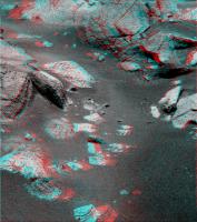
Unless this meteorite arrived here rather recently, it probably is sitting on the bedrock below the sand. Although unlikely, it is tempting to imagine that it could be partially embedded in the bedrock.
I am hoping we get some closer images. I don't see any Widmanstatten patterns as were apparent on Block Island, but if we do find them it would strongly suggest Shelter Island and Block Island were once part of the same impactor. We can see apparent inclusions in this rock (see attachment). Although they look like inclusions, they don't appear very different spectrally from the rest of the meteor.

|
Posted by: Ant103 Oct 5 2009, 04:58 PM
EGK, maybe by cleaning the dust of Shelter Island you will be able to have the genie ? And let Oppy exauces 3 wishes :
- have new boggie system for roving ;
- have a new robotic arm ;
- be teleported to the nearside of Endeavour Crater.
Mmmmh?? What? You're calling the doctor? 
So!
The Sol 2024 view, with selected frame to show SI in his context :
http://www.astrosurf.com/merimages/Opportunity/2009/Sol2024-SI-pano.jpg
And a pancam insertion to show his context :
http://www.astrosurf.com/merimages/Opportunity/2009/Sol2024-SI-navcam-context.jpg
Posted by: nprev Oct 6 2009, 12:12 AM
No worries, Ant; nobody's gonna take you to the funny farm when you keep cranking out gorgeous images like that!!! Wow!
Posted by: fredk Oct 6 2009, 02:31 AM
Stereo pancam view of most of Shelter Island:

|
Posted by: Tman Oct 6 2009, 07:14 AM
edit: I really don't know a lot about the subject. Have Iron meteors on Earth been known to break up on entry? My impression is that they are pretty solid lumps, not likely to break up.
If you look at it from another site, it is no longer such well shaped. Could be also a fragment from a broke up body I guess.
https://qt.exploratorium.edu/mars/opportunity/pancam/2009-10-05/
There're falls of irons on Earth where there is a strewn field. One of the known biggest is
http://en.wikipedia.org/wiki/Gibeon_%28meteorite%29
http://www.meteoritemarket.com/GNinfo.htm
How dense the atmosphere on Mars had to be proper then, I don't know.
Posted by: Stu Oct 6 2009, 07:57 AM
In Nov 1957, an iron meteoroid with an estimated mass of 900,000kg exploded above Sikhote Alin in Russia, showering the ground below with around 100,000kg of shrapnel-like fragments. I have a small piece, but this pic of a much larger specimen gives a good idea of what can happen to a big iron meteorite when it takes on Earth's atmosphere...
http://www.towercrystals.com/meteorites/sikhote/big/images/RHB_4074.jpg
I think it's more likely that BI and SI and the others we've seen on Meridiani were once parts of the same rocky-iron meteorite. The cavities we see are the result of both the atmospheric ablation of softer, rockier material and erosion after landing by the martian environment.
Posted by: centsworth_II Oct 6 2009, 06:11 PM
So there are! http://www.meteorite-martin.de/english/iron_en.html
It's interesting to see how important strewn fields are to the meteorite sales trade.
I guess it is possible that Meridiani is the site of a Martian strewn field.
Posted by: ElkGroveDan Oct 6 2009, 06:19 PM
Or more likely, several overlapping strewn fields.
Posted by: fredk Oct 7 2009, 04:10 AM
Next "island" coming into view near the top of this drive direction pancam:
http://qt.exploratorium.edu/mars/opportunity/pancam/2009-10-06/1P308129162EFFA7C4P2421L6M1.JPG
Could it be our next stop?
Posted by: nprev Oct 7 2009, 04:38 AM
Good grief. Meridiani Meteoritefest '09?
This is all beginning to feel like some kind of dream I had when I was a kid!
Posted by: eoincampbell Oct 7 2009, 04:40 AM
Can you guys tell how big that is compared to BI from this shot?
Posted by: Shaka Oct 7 2009, 05:36 AM
Same ballpark, but seemingly light in color rather than iron dark.
Posted by: nprev Oct 7 2009, 05:41 AM
Yeah...I was gonna mention that too, Shaka.
At this point, an anomalous native Martian rock would be a novelty. Or maybe it's a stony meteorite, who knows? (We're gonna find out...hee, hee, it's like bein' a kid in a candy store!)
Posted by: Shaka Oct 7 2009, 05:48 AM
BTW, whatever happened to Sugar Daddies?
Posted by: CosmicRocker Oct 7 2009, 06:06 AM
That rock is relatively far away, and looks significantly larger than BI to me.
Posted by: Stu Oct 7 2009, 07:10 AM
Wow... look at that... that looks like a BIG meteorite to me, with a very dramatic cavity on one side...

|
Meanwhile, Oppy is edging around Shelter Island, and the other side of this meteorite appears to have some absolutely fascinating structure...

|
What a wonderful place Meridiani is...
Posted by: Stu Oct 7 2009, 12:53 PM
Oppy's playing shadow puppets again..
http://twitpic.com/kl8jo/full
Posted by: fredk Oct 7 2009, 01:59 PM
The best we can do until we pin down its location on the map is to make a comparison like this:

|
I've enlarged the new rock image until the rock appears the same distance below the horizon as BI does in the right frame. Then, assuming the land is flat and level (not a bad guess for Meridiani), both frames must be to the same scale. So you can see that the new rock is a bit larger than BI, especially in height.
In terms of colour, it's not clear to me yet if the light upper part is a reflection off of shiny metal, or bright rock.
And just for the record Ustrax first posted this new rock http://www.unmannedspaceflight.com/index.php?s=&showtopic=6204&view=findpost&p=147061
Posted by: Julius Oct 7 2009, 02:07 PM
I'm thinking........how plausible is it to find other rock types around this area which were blasted off following the formation of Endeavour crater....is there a chance that we could find phylosilicates before we even get to the crater itself..will such rocks survive the blast which formed the crater??
Posted by: Stu Oct 7 2009, 02:24 PM
Great work fredk - as usual! - and yep, congrats to our Eagle Eye Ustrax who spotted it first. I have very high hopes for this object, I don't mind admitting, especially if it's bigger than Block Island.
Posted by: sdavies Oct 7 2009, 02:36 PM
I think I see light reflecting off cubical crystals in the picture in post 202, and in the picture in post 203 seems to show hollow regions where hexagonal and cubical crystals have melted out.
Steve
Posted by: charborob Oct 7 2009, 03:09 PM
You're not taking into account the curvature of the Martian surface
, but I guess you can safely ignore it.
Posted by: PDP8E Oct 7 2009, 08:49 PM
Does anyone know where the approximate location of 'new rock' is on the route map?
(based on the pancam / 09-10-01 / 1P307514406EFFA700P2418L6M1.JPG )
I guess the better question is how do you compare the pose of the camera image to a direction?
Posted by: Phil Stooke Oct 7 2009, 10:01 PM
Nooooo - not another rock!
Phil
Posted by: fredk Oct 7 2009, 11:39 PM
The direction is to the WNW. Distance is much harder to pin down. Staring at the images and trying to match patches of bedrock I'd guess 100 or 150 metres. That agrees roughly with a distance estimate based on a size of around 2/3 metre.
Any candidates in the hirise imagery out there?
Posted by: BrianL Oct 7 2009, 11:49 PM
I share your pain, Phil. Remember when I posted http://www.unmannedspaceflight.com/index.php?showtopic=5497&st=60&p=127352&#entry127352?
I was wrong. I admit it, I was wrong, Doug was right. Perhaps not for the exact reason he gave, but he was right. It is painful. Made even more so by having the World's Biggest Meteorite Fan in here cheerleading.
Brian
Posted by: CosmicRocker Oct 8 2009, 04:46 AM
Posted by: vikingmars Oct 8 2009, 07:59 AM
Oh No !
NO more rocks please ! Let's go Please, listen to the opinions coming from the "Endeavour Party" !
Posted by: ustrax Oct 8 2009, 09:54 AM
That gives me the right to name it...
Gardiners Island, why? Because there may be an hidden treasure there...
"The pirate/privateer Captain Kidd buried treasure on the island in June, 1699. Kidd stopped at the island while sailing to Boston to attempt to clear his name. With the permission of the proprietor, Mrs. Gardiner, he buried $30,000 in treasure in a ravine between Bostwick's Point and the Manor House. For her troubles he gave her a piece of gold cloth (a piece of which is now at the East Hampton library) captured from a Moorish ship off Madagascar, as well as a bag of sugar. Kidd warned that if the treasure was not there when he returned, he would kill the Gardiners, which was an idle threat. Kidd was to be tried in Boston and Gardiner was ordered by Governor Bellomont to deliver the treasure as evidence. The booty included gold dust, bars of silver, Spanish dollars, rubies, diamonds, candlesticks, and porringers. Gardiner kept one of the diamonds which he gave to his daughter. A plaque on the island marks the spot but it is on private property."
Posted by: Nirgal Oct 8 2009, 12:25 PM
NO more rocks please ! Let's go Yes. This too is (was?) the overall strategy as stated http://www.planetary.org/news/2009/0131_Mars_Exploration_Update_Spirit_and.html:
Posted by: Oersted Oct 8 2009, 02:46 PM
After 5 years on Mars, do the accumulated, say, 50 days of checking out 10 interesting rocks along the way really matter?
Posted by: Tman Oct 8 2009, 04:17 PM
I still do not like the very orange ambience though, but it seems to be http://marswatch.astro.cornell.edu/pancam_instrument/images/True/Sol1998B_P2553_1_True_RAD.jpg. Here my guess how the view toward the new rock could look like:
http://www.greuti.ch/oppy/SOL20271PL256++.jpg
Through all the image "processing", the rock keeps bluish in sunlight like parts of the other iron meteorite. So it may be another one - time will tell...
Edit: sry it is Sol2027 http://www.greuti.ch/oppy/SOL20271PL256++.jpg
Posted by: PaulM Oct 8 2009, 04:41 PM
When I look at the rock that Ustrax spotted on the horizon what I see is an inclined flat surface:
http://www.greuti.ch/oppy/SOL20471PL256++.jpg
This makes me think that it is a sedimentary rock. The local sedimentary rocks seem very weak and poorly cemented. I wonder if this is a strongly cemented sedimentary rock from far away.
Posted by: serpens Oct 9 2009, 12:16 AM
NO more rocks please ! Let's go !
Opportunity is a robot geologist, not a tourist bus. The need to reverse direction and travel back to BI seems a good example of the penalty paid when daily distance driven becomes more important than analysis of surroundings at the end of a drive.
From a reliability point of view Opportunity is living on borrowed time. I for one applaud the practical approach of the Rover team in accumulating data where possible rather than putting the pedal to the metal.
Posted by: Phil Stooke Oct 9 2009, 01:41 AM
Everything's good! Driving and looking at rocks, all good. But one can have a preference... I just want to see new territory, a new kind of surface after several years of dusty drifts.
Phil
Posted by: vikingmars Oct 9 2009, 08:24 AM
I could not say it better than Phil !...And just imagine the global view on Endeavour
we will have a few km south from here once we are over the crest and starting going down the (gentle) slope 
Posted by: climber Oct 9 2009, 09:29 AM
I'm on board (if I can say so) Phil & Olivier. I recognise that stopping at "rocks" is even good for RF, plenty of science, etc.
But I'm a Climber (not joking) and I'd like to leave flatness as soon as we can and not taking the "Long and Winding Road" (that leads (to) Endeavour).
As Phil say, this is just a preference...
Posted by: centsworth_II Oct 9 2009, 10:41 AM
Think how much more boring the "years of dusty drifts" would be if not punctuated by finds like these meteorites.
Posted by: BrianL Oct 9 2009, 12:47 PM
Quite true, but to some of us, driving on Mars is like sentence construction. If, you punctuate too... often; reading(?) is, less, "enjoyable".
Posted by: Ant103 Oct 9 2009, 02:55 PM
SI in color on Sol 2029
http://www.astrosurf.com/merimages/Opportunity/2009/1P308310945EFFA7CHP2423RCoul.jpg
Posted by: centsworth_II Oct 9 2009, 03:49 PM
This is turning into a great Onion article:
Scientists Worry that Mars Rover is Making too Many Discoveries
Stung by complaints from space enthusiasts, NASA scientists sought ways to reduce the number of new discoveries being made by the Mars rover, Opportunity. "It's annoying," said one, referring to multiple discoveries of iron meteorites on the Meridiani plain, "we were getting used to week after week of monotonous terrain, and now there are just too many things to look at." A colleague agreed, "the first time or two we ran across an iron meteorite on Mars it was interesting, even exciting. But we've now come to dread the sight of those blasted things."
A solution may be at hand however. "We're reprogramming the cameras to ignore any future meteorites," said one rover driver. "A program has been written and will be sent to the rover on Mars," he said. From this point on, all images will be analyzed on board and those containing meteorites will be deleted from the memory and not transmitted to Earth. "You can't be distracted by what you can't see," said the driver. Both scientists nodded in agreement.
Posted by: Airbag Oct 9 2009, 04:50 PM
That is way better than the actual Mars rover related Onion ones I have seen so far and yet totally in the same style - a classic!
Airbag
Posted by: climber Oct 9 2009, 07:34 PM
Watching LCROSS impact and lack of immediate evidence of it I was thinking that Opportunity is may be the only Spacecraft in the history discovering what we're asking her to discover!
Do you want sedimental rocks? First shot shown them
Do you want hematite? First month shown them
More sediments? Go to this crater nearby... and here they are
A bigger one? What? Too far away? Here I come Victoria
Even a much Bigger one, let's go for it
Whaoua this is a meteroid! What about many more?
This little Lady is incredible and yes, unique.
Posted by: Tman Oct 9 2009, 08:09 PM
...and imagine, she could identify that sometime a larger iron meteorite is broken apart in the ancient Mars atmosphere!
Posted by: climber Oct 9 2009, 08:35 PM
http://www.astrosurf.com/merimages/Opportunity/2009/1P308310945EFFA7CHP2423RCoul.jpg
I bet Dan will see a dinausor's head on this one...
Posted by: ElkGroveDan Oct 9 2009, 10:57 PM
Too late. You already did.
Posted by: volcanopele Oct 9 2009, 11:04 PM
Yep, that's going in the top 10 Space pics of the year!
Posted by: Nirgal Oct 9 2009, 11:05 PM
The goal of Reaching Endeavor was set by the Rover Lead neither for sightseeing nor as a mere end in itself ("Selbstzweck") but the idea is to use those powerful wheels as our robot geologist's "seven-league boots" for reaching a far away place where she can do the greatest geology science there. So it's always about science and geology of course. The great new vistas are a very welcome by-product
but the primary goal is for the science to be done at Endevaour with as much remaining working science instruments as possible - to study an entirely new realm of possible scientific wonders waiting for our lucky robot geologist there Yes. and that's the reason why it is unlikely that Oppy can fully fulfill both of the two conflicting goals: many extensive rock studies *and* reaching Endeavor. So a priority must be set for preferring one of the two goals. And it has been my understanding from the press updates (but correct me if I'm wrong or missed a recent change in strategy) that the priorities as stated by the Rover Lead are: 1. Reaching Endeavour and 2. Do regular stops along the way only for a) sparse routine sampling and
new interesting and unexpected discoveries along the way. So this seems to be the most sensible approach that gives the chance to reach the main goal while at the same time not totally neglect intermediate science stops ...
Posted by: Stu Oct 9 2009, 11:21 PM

|
Posted by: mhoward Oct 9 2009, 11:23 PM
That is, like, the coolest picture ever.
(Adding: referring to both Ant's and Stu's versions.)
Posted by: ElkGroveDan Oct 10 2009, 02:57 AM
Now that I've checked the raws I have to agree. At first I thought it was creative artwork that Astro0 did as a play on Stu's hand-puppet comment from last week. So after three versions of it popped up I went back and checked and holy smokes, that IS a real shadow, If I didn't know better, I'd even suggest that someone arranged it on purpose.
Posted by: alan Oct 10 2009, 03:54 AM
Look out Oppy! There is a Marsasaurus rex sneaking up behind you!
Posted by: nprev Oct 10 2009, 04:48 AM
That's an awesome image & caption on so many levels. One of your best, Stu!
Posted by: brellis Oct 10 2009, 07:39 AM
"Oppy, back away from the Marsosaur..."
Oppy says, "It belongs in a museum!"
cue Indy Jones theme
Posted by: ustrax Oct 10 2009, 10:11 AM
I'm wondering why is it taking so long for one of you guys to do a http://elc.polyu.edu.hk/CiLL/staff/jurassic_park_ver2.jpg version out of this...
Posted by: Ant103 Oct 10 2009, 11:25 AM
So, here we go

|
Posted by: Hungry4info Oct 10 2009, 01:17 PM
(with apologies to Ant103)

|
Posted by: Tman Oct 10 2009, 01:27 PM
Perfect!
That would have been the right logo for the early weeks in Gusev as some people saw everywhere fossilized bones.
Posted by: Hungry4info Oct 10 2009, 01:55 PM
Ahh no kidding. More mummies in Gusev than in Egypt.
Posted by: fredk Oct 10 2009, 02:57 PM
I think the picture is clear to me now, and it's so terrifying my fingers are almost frozen as I type out this message.
Why have we seen this Marsosaur only now?
That's not a meteorite.
That's an egg.
That's right, an iron-armoured egg of the Marsosaur.
Oppy, get the &%#@ out of there. Fast!
Posted by: Hungry4info Oct 10 2009, 03:03 PM
As good a reason as any to put the pedal to the metal and get to Endeavour.
Posted by: NickF Oct 10 2009, 04:22 PM
Oddly appropriate - one wonders if Shelter Island has been quietly sitting there since the Martian equivalent of the Jurassic period.
Posted by: ustrax Oct 11 2009, 12:00 AM
That's exactly what I was talking about...great work!
Posted by: PDP8E Oct 11 2009, 03:45 AM
here is my 'best guess' as to the location of the 'new rock':

|
your mileage may vary...
Cheers,
Posted by: ElkGroveDan Oct 11 2009, 04:23 AM
It looks like some more Pancam shadow images from sol 2029 just showed up.

|
Posted by: nprev Oct 11 2009, 04:35 AM
In the lower right corner image, the dragon has transformed into a bunny!
Posted by: Hungry4info Oct 11 2009, 05:01 AM
O_O That does look like a bunny.
Posted by: ElkGroveDan Oct 11 2009, 05:04 AM
Nothing gets past you guys, except maybe a goose, a dachsund, a goat, a pig, a deer, and an old man.
Posted by: nprev Oct 11 2009, 05:07 AM
I just figured that spotting the bunny right away would do the most possible damage to my carefully crafted macho image...
Posted by: Hungry4info Oct 11 2009, 05:09 AM
Ahh but it's shadow puppets....
[deep echoing 1950's-sci-fi manly voice]
... In Space!!
Posted by: Stu Oct 11 2009, 05:21 AM
Thanks Dan, I just spat my cornflakes out all over my keyboard, laughing so much when I opened that pic.
Sending me off to work at 7am on a should-be-in-bed Sunday morning with a smile!
Posted by: CosmicRocker Oct 11 2009, 06:34 AM
I ejected a mouthful of beverage through my nostrils, similarly damaging my keyboard, and probably my brain.
Nice work, Dan. That was one of the funniest things I've seen around here in a while. I was trying to comment on where the new rock might be in the HiRise imagery when I noticed your montage. I was unable to do any serious work after that.
Genius, Dan, genius.
Posted by: Tman Oct 11 2009, 08:16 AM
And regarding Endeavour time of arrival, I fear that has some influence too...
Dan, didn't know "she" is that gifted.
Posted by: Phil Stooke Oct 11 2009, 12:16 PM
Very good, Dan!
Phil
Posted by: Hungry4info Oct 11 2009, 01:25 PM
After reading a few of the posts, I was confused by people's reaction to those images. And then it suddenly hit me.
Hold on wait a sec.... what?
I just realised that those images weren't real....
Posted by: Stu Oct 11 2009, 02:25 PM
Rather like this new 3d view...
http://twitpic.com/l490f
Posted by: Tman Oct 11 2009, 02:26 PM
I have to admit after opening the image (browser size) I first clicked/checked JPL's site too and thought (damn, why get the Americans suddenly different/more actual pics here - then, hey wait a minute, why he bother doing a copy of the full JPL page...)
Posted by: Poolio Oct 11 2009, 04:18 PM
Run Away!!!

|
Posted by: Burmese Oct 11 2009, 10:05 PM
So when the Rover drivers are plotting drives and pancam shots like that, does the simulation software show where the shadows will fall? They obviously are keen to where shadows fall at other times, such as if/when a motor that needs morning warming might be in a shadow.
Posted by: Ant103 Oct 12 2009, 12:01 AM
I don't know, it depends of how many swallows you need to carry the meteorite. Yes, with a wire.
Dan : I laugh at lot of by seeing you're picture. In the first time I say to myself "but what the hell a screen of raw data section of MER website", and after seeing the "shadows", yes, very funny indeed .
Posted by: Stu Oct 12 2009, 10:59 AM
Couple'a new 3D views...

|

|
Posted by: Stu Oct 12 2009, 01:36 PM
Day off, so I thought I'd spend a little while virtually walking back towards Victoria, retracing Oppy's steps, seeing if any other meteorites were passed... think I found a couple of small ones... ?
http://twitpic.com/l8zpq
(apologies if anyone else spotted and reported these at the time, I'm just having a bit of fun here, ok? )
Posted by: ElkGroveDan Oct 12 2009, 01:49 PM
Stu you might also browse over the HIRISE images and look for "Block Island" or larger candidates. As I recall there was something large off to the East prior to Purgatory.
I have the day off too. Celebrating a day in honor of a famous Italian. But it will be lots of back breaking work around the house and yard.
Posted by: Stu Oct 12 2009, 02:03 PM
I started doing that but started to give myself a migraine. And I don't even have migraines...
I'm happy Rockhounding - staring at the ground beneath my boots and scuffling along in the dust - for now.
Posted by: BrianL Oct 12 2009, 02:10 PM
Off work as well, today is Thanksgiving in Canada. So what better day than to give thanks to our robotic friends far away (and their handlers) for so many years of wonderful exploration.
Now... drive, drive, drive! (And that goes for you too, Spirit).
Posted by: Ant103 Oct 12 2009, 02:43 PM
Stu, you're stunning anaglyphs give me the idea to do a QTVR reprojection of Sol 2031 and 2031 FHC view of Shelter Island
So, Sol 2031 in this post :

Posted by: Ant103 Oct 12 2009, 02:44 PM
And Sol 2032 in this post :
Posted by: fredk Oct 12 2009, 04:42 PM
Anaglyph of top/backside of SI:

|
I couldn't get the alignment perfect so it may induce some headaches...
So now that we're circumnavigating SI, does that mean back to driving soon, like what happened at BI?
Thanks for the reminder, Stu. Those were part of the cobble field around Santorini, and http://www.unmannedspaceflight.com/index.php?s=&showtopic=5702&view=findpost&p=133502 So probably a good bet those were too, but I don't recall anything official...
Posted by: mhoward Oct 12 2009, 05:00 PM
Nice work, Ant!
Posted by: Julius Oct 12 2009, 05:11 PM
1.It seems that these meteorite rocks have been sitting in Meridiani for billions of years.
2.Sulphate bedrock seems to indicate that this landscape was drenched in ground-surface shallow waters.
3.What effect would water have on the meteorite rocks if any??The unaltered nature of the Iron Nickle rocks would indicate that Meridiani has been dry for most of Martian history??
Posted by: Stu Oct 12 2009, 05:19 PM
Very nice work, Ant!
New 3D view of Shelter Island...

|
Posted by: climber Oct 12 2009, 07:28 PM
You VERY funny guy
Posted by: HughFromAlice Oct 12 2009, 07:47 PM
Really nice work Fred and Stu. Besides the good work, I really enjoy the different interpretations of the same subject - makes me think! The only headache I got from you Fred was that I really should be starting work and I've spent time looking at your anaglyph !!!!!!
Posted by: Tman Oct 12 2009, 09:05 PM
http://twitpic.com/l8zpq
The upper left is on the Pancam true color page http://marswatch.astro.cornell.edu/pancam_instrument/true_color35.html. Both look like meteorites.
Posted by: Stu Oct 12 2009, 09:11 PM
Yeah, I said they might have been spotted before. Just thinking aloud...
Posted by: Oersted Oct 12 2009, 09:40 PM
|
|
Holy maloney, the Pancam is beginning to EAT the meteorite!
Posted by: Oersted Oct 12 2009, 09:49 PM
..and the first glimpse of Martian cities, showing functional but haphazardly placed architecture...
http://qt.exploratorium.edu/mars/opportunity/pancam/2009-10-11/1P307155496EDNA63QP2560R1M4.JPG
Posted by: SteveM Oct 12 2009, 10:39 PM
No, its a monochrome Martian Mondrian.
Steve M
Posted by: Ant103 Oct 12 2009, 11:07 PM
Why not? 
Posted by: Tesheiner Oct 13 2009, 05:35 AM
Tomorrowsol it'll be. And check the heading of the post-drive navcam mosaic.
02034::p1211::03::2::0::0::2::0::4::ultimate_front_haz_1_bpp_pri_15
02034::p1312::07::2::0::0::2::0::4::rear_haz_ultimate_2_bpp_pri15
02034::p1989::02::6::0::0::6::0::12::navcam_3x1_az_294_3_bpp_pri22_17_22
Towards "new rock"?
Posted by: Stu Oct 13 2009, 05:55 AM
"pri"... maybe "Prall's Island"...
Posted by: djellison Oct 13 2009, 06:48 AM
Pri = Priority, i.e. how important the images are and thus what order they'll come down the pipe.
Posted by: Stu Oct 13 2009, 03:38 PM
Ah, I see. Thanks for the clarification. Lots more islands to choose from. :-)
Posted by: djellison Oct 13 2009, 05:13 PM
Priority is mentioned in one of the old Pancam-updates-with-Jim-Bell I did years ago
Posted by: Stu Oct 13 2009, 06:16 PM
Today's postcard from Shelter Island...

|
Posted by: Ant103 Oct 13 2009, 11:14 PM
Just a little return in the past to show you the color version of the quite huge panoramic of Nereus Crater at the Sol 2010 :
http://www.astrosurf.com/merimages/opportunity-2009.html#Sol2010
Posted by: Tesheiner Oct 14 2009, 09:25 AM
Here's the navcam mosaic taken thisol (2034) and pointing towards NW. Opportunity said "good bye" to Shelter Island and drove 60+ on that same NW heading. Does anybody see "new rock" in the vicinity?

|
Posted by: Stu Oct 14 2009, 09:56 AM
Nothing's jumping out at me... I strongly suspect one of the meteorite haters here hacked into Oppy's drive commands and steered her away from anything that looked like it fell from above...
Posted by: Nirgal Oct 14 2009, 09:57 AM
No "meteorite hater" here ! only a passionate "Endeavor lover"
No ... but I do imagine lots of really "new rocks" in the vicinity of Endeavor Crater
"Drive, Drive, Drive ..." .... a wise man once said
Posted by: djellison Oct 14 2009, 10:32 AM
This direction is the one I would have driven, meteorite or no meteorite. It's onto the nearest large expanse of exposed rock - best for driving
Posted by: Stu Oct 14 2009, 10:34 AM
Some new images just came down... must have been a glitch in the system somewhere... this is the real view ahead...

|
We might be here a while...
Posted by: remcook Oct 14 2009, 11:06 AM
you got to be kidding! we'll never get anywhere like that!
edit- that would actually be really cool
Posted by: PDP8E Oct 14 2009, 01:54 PM
Stu,
The new images you found have finally got me off the fence and into incorporation. (thanks buddy!)

|
Investors, please contact me offline.
Satisfaction Guaranteed (hey, we have the pictures to prove it!)
Cheers
Posted by: fredk Oct 14 2009, 02:05 PM
Yikes! The biggest of them are a couple metres across! How did we miss them on hirise?
Seriously, about "new rock", my best guess is that it's a bit to our south, so off to the left in your new navcam mosaic. It may be quite close. Unfortunately (fortunately?) we may miss it since that's the entire navcam mosaic (3x1).
Powered by Invision Power Board (http://www.invisionboard.com)
© Invision Power Services (http://www.invisionpower.com)