Sol 90+, Extended mission |

  |
Sol 90+, Extended mission |
 Aug 28 2008, 02:56 PM Aug 28 2008, 02:56 PM
Post
#31
|
|
|
Member  Group: Members Posts: 877 Joined: 7-March 05 From: Switzerland Member No.: 186 |
The azimuth data of the sol 90 sunrise images are a bit odd:
lg_24930 50:52 elevation 5.03164 degrees and azimuth 13.2373 degrees lg_24931 51:45 elevation 5.03367 degrees and azimuth 13.2360 degrees lg_24932 56:50 elevation 5.03470 degrees and azimuth 13.2369 degrees What's the exact meaning of "The camera pointing was..."? Does this correspond to the actual elevation (notional horizon) and azimuth degrees seen from the same point as the camera? -------------------- |
 |
 
|
|
Aug 28 2008, 03:28 PM
Post
#32
|
|
|
Solar System Cartographer Group: Members Posts: 10146 Joined: 5-April 05 From: Canada Member No.: 227 |
... or the azimuth and elevation in the lander's coordinate system?
Phil -------------------- ... because the Solar System ain't gonna map itself.
Also to be found posting similar content on https://mastodon.social/@PhilStooke NOTE: everything created by me which I post on UMSF is considered to be in the public domain (NOT CC, public domain) |
|
|
|
|
Aug 28 2008, 03:42 PM
Post
#33
|
|
|
Member Group: Members Posts: 877 Joined: 7-March 05 From: Switzerland Member No.: 186 |
If it is the azimuth and elevation in the lander coordinate system (pointing means the center of the image probably), is then the Mars24 solar elevation of 1.3° and azimuth 11.8° definitely correct?

-------------------- |
|
|
|
|
Aug 28 2008, 07:02 PM
Post
#34
|
||
 Administrator Group: Admin Posts: 5172 Joined: 4-August 05 From: Pasadena, CA, USA, Earth Member No.: 454 |
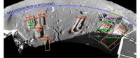
I'm making a new map of the work volume with James' sol 84 pan as a base. Here's the names I've come up with so far. Is there a name for the dump piles at the top of Snow White? Are there any other names that should be on this map?
--Emily
Attached thumbnail(s)
-------------------- My website - My Patreon - @elakdawalla on Twitter - Please support unmannedspaceflight.com by donating here.
|
|
|
|
|
|
|
Aug 29 2008, 09:20 AM
Post
#35
|
|
 Member Group: Members Posts: 144 Joined: 17-July 07 From: Canberra Australia Member No.: 2865 |
Hmmm. I appreciate that the journalistic hype over perchlorates probably upset the applecart. But really, at least the old television stations had the courtesy to put up program interruption signs. I guess NASA and Artizona St U have decided to emulate the ESA.
|
|
|
|
|
Aug 29 2008, 11:03 AM
Post
#36
|
|
|
Forum Contributor Group: Members Posts: 1372 Joined: 8-February 04 From: North East Florida, USA. Member No.: 11 |
My nickname at school was Ichabod, I was skinny and brainy, lol. I am now not skinny and for the brains, well you know how age affects those, and beer.....
|
|
|
|
|
Aug 29 2008, 12:39 PM
Post
#37
|
|
|
Member Group: Members Posts: 877 Joined: 7-March 05 From: Switzerland Member No.: 186 |
Sometimes you really feel older
 -------------------- |
|
|
|
|
Aug 29 2008, 06:16 PM
Post
#38
|
|
|
Junior Member Group: Members Posts: 21 Joined: 6-August 08 From: Augusta, Maine Member No.: 4305 |
QUOTE (Aussie @ Aug 29 2008, 02:20 AM)  Hmmm. I appreciate that the journalistic hype over perchlorates probably upset the applecart. But really, at least the old television stations had the courtesy to put up program interruption signs. I guess NASA and Artizona St U have decided to emulate the ESA. Arizona State?? You just stepped into it, Oz. 
|
|
|
|
|
Aug 29 2008, 07:50 PM
Post
#39
|
|
 Member Group: Members Posts: 101 Joined: 29-January 06 Member No.: 667 |
JPL Phoenix Mission News: NASA Phoenix Mission Conducting Extended Activities on Mars (August 29)
QUOTE The team is currently working to diagnose an intermittent interference that has become apparent in the path for gases generated by heating a soil sample in the Thermal and Evolved-Gas Analyzer to reach the instrument's mass spectrometer. Vapors from all samples baked to high temperatures have reached the mass spectrometer so far, however data has shown that the gas flow has been erratic, which is puzzling the scientists. |
|
|
|
|
Aug 29 2008, 08:07 PM
Post
#40
|
|
|
Senior Member Group: Members Posts: 2918 Joined: 14-February 06 From: Very close to the Pyrénées Mountains (France) Member No.: 682 |
however data has shown that the gas flow has been erratic
"Something" must be breezing inside 
-------------------- |
|
|
|
|
Aug 30 2008, 06:21 AM
Post
#41
|
|
 Senior Member Group: Members Posts: 2228 Joined: 1-December 04 From: Marble Falls, Texas, USA Member No.: 116 |
QUOTE (elakdawalla @ Aug 28 2008, 01:02 PM) I'm making a new map of the work volume with James' sol 84 pan as a base. Here's the names I've come up with so far. Is there a name for the dump piles at the top of Snow White? Are there any other names that should be on this map? Em: I really appreciate your awesome work volume maps. I have no help with names for those tailings piles.What I would really like to see on such maps is an outline of the polygon boundaries in the area. Are there not any within reach of the robotic arm? -------------------- ...Tom
I'm not a Space Fan, I'm a Space Exploration Enthusiast. |
|
|
|
|
Aug 30 2008, 06:36 AM
Post
#42
|
|
|
Senior Member Group: Members Posts: 2228 Joined: 1-December 04 From: Marble Falls, Texas, USA Member No.: 116 |
QUOTE (Tman @ Aug 29 2008, 06:39 AM) Sometimes you really feel older I just had to say, "Sometimes you really are older." 
-------------------- ...Tom
I'm not a Space Fan, I'm a Space Exploration Enthusiast. |
|
|
|
|
Aug 31 2008, 05:11 AM
Post
#43
|
|
|
Senior Member Group: Members Posts: 2228 Joined: 1-December 04 From: Marble Falls, Texas, USA Member No.: 116 |
QUOTE (CosmicRocker @ Aug 30 2008, 12:21 AM) What I would really like to see on such maps is an outline of the polygon boundaries in the area. Are there not any within reach of the robotic arm? Duh! I forgot that some of our members had posted several polar pans. James' Phoenix Polar Peter Pan is one of them. Should we call it the P4 pan? If anyone can do it, I think a vertical projection of the imagery would be helpful.As best as I can tell, all of the trenches so far have been within this polygon, and some of the local polygon's boundaries are barely within reach of the robotic arm. Can we dig into a polygon boundary, or not? I'm commenting from my RV in Lufkin, Tx, as we evacuate the gulf coast ahead of hurricane Gustav. I am hoping to avoid the storm and swing back behind it, as it comes ashore. Wish us luck. -------------------- ...Tom
I'm not a Space Fan, I'm a Space Exploration Enthusiast. |
|
|
|
|
Aug 31 2008, 05:49 AM
Post
#44
|
|
|
Member Group: Members Posts: 101 Joined: 29-January 06 Member No.: 667 |
QUOTE (CosmicRocker @ Aug 30 2008, 10:11 PM) Can we dig into a polygon boundary, or not? Planetary Society Weblog: Catching up with Phoenix, through sol 91 QUOTE Stone Soup is in a region that is a boundary between two polygons, and the ice table doesn't seem to continue across that boundary, so they're getting much deeper -- 18 centimeters, according to the latest press release. |
|
|
|
|
Aug 31 2008, 06:45 AM
Post
#45
|
|
 The Poet Dude Group: Moderator Posts: 5551 Joined: 15-March 04 From: Kendal, Cumbria, UK Member No.: 60 |
Take care, CR, and any other UMSF members or lurkers in the path of the storm.
-------------------- |
|
|
|
|

|
Lo-Fi Version | Time is now: 19th April 2024 - 01:58 PM |
|
RULES AND GUIDELINES Please read the Forum Rules and Guidelines before posting. IMAGE COPYRIGHT |
OPINIONS AND MODERATION Opinions expressed on UnmannedSpaceflight.com are those of the individual posters and do not necessarily reflect the opinions of UnmannedSpaceflight.com or The Planetary Society. The all-volunteer UnmannedSpaceflight.com moderation team is wholly independent of The Planetary Society. The Planetary Society has no influence over decisions made by the UnmannedSpaceflight.com moderators. |
SUPPORT THE FORUM Unmannedspaceflight.com is funded by the Planetary Society. Please consider supporting our work and many other projects by donating to the Society or becoming a member. |
|