

New Olympus Mons image, 6 km high scarp |

  |
New Olympus Mons image, 6 km high scarp |
 Mar 3 2006, 03:16 PM Mar 3 2006, 03:16 PM
Post
#1
|
|
 Member  Group: Members Posts: 531 Joined: 24-August 05 Member No.: 471 |
http://www.esa.int/SPECIALS/Mars_Express/SEMIPVMVGJE_0.html - Eastern scarp of Olympus Mons (Press Information)
http://www.esa.int/SPECIALS/Mars_Express/SEMIPVMVGJE_1.html - Eastern scarp of Olympus Mons (Images) Image was taken on Nov. 23, 2004: 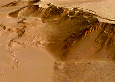 Lava flows are up to 200 million years old and the network-bearing area was geologically active as recent as 30 million years ago. -------------------- - blue_scape / Nico -
|
 |
 
|
| Guest_Richard Trigaux_* |
Mar 3 2006, 03:38 PM
Post
#2
|
|
Guests |
I alway wondered where this huge scarp is coming from... This is an unique feature in all the shield volcanoes. It cannot result from volcanic activity itself, and it is clear on the picture that the more recent lava flows are above it. It is a bit as if there was a piece of land lifted up, coinciding witht he volcano shield.
One of my favorite hypothesis is that there were huge landslides all around Olympus Mons, due to some rain or moisture which reached a certain altitude, but left the highest parts. Some say it was rather glacial activity. But in any way it is strange that this scarp is just at the bottom of the volcano slope. |
|
|
|
|
Mar 4 2006, 07:01 PM
Post
#3
|
|
|
Member Group: Members Posts: 531 Joined: 24-August 05 Member No.: 471 |
QUOTE I alway wondered where this huge scarp is coming from... This is an unique feature in all the shield volcanoes. It is a unknown surface phenomenon of shield volcanoes? 
-------------------- - blue_scape / Nico -
|
|
|
|
|
Mar 4 2006, 08:05 PM
Post
#4
|
|
|
Senior Member Group: Members Posts: 1276 Joined: 25-November 04 Member No.: 114 |
I remember reading Olympus Mons is not the tallest feature on Mars?
Is this true? |
|
|
|
|
Mar 4 2006, 08:13 PM
Post
#5
|
|
|
Member Group: Members Posts: 249 Joined: 11-June 05 From: Finland (62°14′N 25°44′E) Member No.: 408 |
No, Olympus Mons is the tallest mountain.
I remember there was a claim many years ago that Arsia Mons could be higher than Olympus Mons. Obviously that wasn't true. -------------------- The universe is not only stranger than we imagine, it is stranger than we can imagine.
|
|
|
|
|
Mar 4 2006, 10:51 PM
Post
#6
|
|
 Chief Assistant Group: Admin Posts: 1409 Joined: 5-January 05 From: Ierapetra, Greece Member No.: 136 |
Amazing images
 Nico -------------------- photographer, space imagery enthusiast, proud father and partner, and geek.
http://500px.com/sacred-photons & |
|
|
|
|
Mar 5 2006, 03:32 AM
Post
#7
|
|
 Member Group: Members Posts: 809 Joined: 11-March 04 Member No.: 56 |
Olympus Mons is so huge that you could probably land a rover on it, and nothing that the rover could show you would even tell you that you were on a mountain.
I know -- let's do it! 
|
|
|
|
| Guest_Richard Trigaux_* |
Mar 5 2006, 07:26 AM
Post
#8
|
|
Guests |
QUOTE (Richard Trigaux @ Mar 3 2006, 04:38 PM)  I alway wondered where this huge scarp is coming from... This is an unique feature in all the shield volcanoes. It cannot result from volcanic activity itself, and it is clear on the picture that the more recent lava flows are above it. It is a bit as if there was a piece of land lifted up, coinciding witht he volcano shield. One of my favorite hypothesis is that there were huge landslides all around Olympus Mons, due to some rain or moisture which reached a certain altitude, but left the highest parts. Some say it was rather glacial activity. But in any way it is strange that this scarp is just at the bottom of the volcano slope. Part of the mystery of Olympus Mons art these strange formations in the north west of it: large spans of terrain which look as it was cut by many crisscrossing faults, the overal form of these spans suggesting a flow. Maybe there was here some special tectonic, which raised Olympus Mons and produced these terrains, a kind of local or reduced plate tectonics. Anyway there is a huge mystery. |
|
|
|
|
Mar 5 2006, 07:48 AM
Post
#9
|
|
|
Senior Member Group: Members Posts: 1870 Joined: 20-February 05 Member No.: 174 |
MOLA proved that Arsia or one of the 3 tharsis volcanoes is a bit higher than Olympus, but Olumpus is much taller above it's base.
|
|
|
|
| Guest_Richard Trigaux_* |
Mar 5 2006, 07:54 AM
Post
#10
|
|
Guests |
QUOTE (edstrick @ Mar 5 2006, 08:48 AM) MOLA proved that Arsia or one of the 3 tharsis volcanoes is a bit higher than Olympus, but Olumpus is much taller above it's base. Olympus Mons is much more voluminous than any other marsian volcano. Its overal diametre is huge. Perhaps if Olympus Mons was raised by some tectonic process, this volume is in fact much smaller. But why a tectonic process would have cut a piece of terrain just the shape and size on the volcano? Because there was (is) a magmatic chamber just that size? |
|
|
|
|
Mar 5 2006, 09:26 AM
Post
#11
|
|
|
Senior Member Group: Members Posts: 1870 Joined: 20-February 05 Member No.: 174 |
There's clear evidence for catastrophic landslides off parts of the basal scarp. Whether the "Olympus Mons Aureole" terrains on the northwest to southwest sides are catastrophic land-slide deposits is much less than clear. There's gravity anomalies over some of them that suggests underlying magma bodies or something. It's all very strange.
|
|
|
|
|
Mar 5 2006, 05:28 PM
Post
#12
|
|
|
Member Group: Members Posts: 688 Joined: 20-April 05 From: Sweden Member No.: 273 |
Huge peripheral landslides may be a quite normal process for large shield volcanoes. Quite a few have occurred around the Hawaian islands which of course are the largest shield volcanoes on Earth, though the vidence is mostly underwater and therefore difficult to study. This may be a case where Martian geology can throw light on geological processes here on Earth.
Incidentally understanding how and when those Hawaian megaslides occur is highly important since they cause tsunamis orders of magnitude larger than the recent one in the Indian Ocean. tty |
|
|
|
|
Mar 6 2006, 08:03 AM
Post
#13
|
|
|
Senior Member Group: Members Posts: 1870 Joined: 20-February 05 Member No.: 174 |
One of the mid-sized Hawiian islands has coral chunks at some elevation like 1 or 1.5 km high on the side of a volcano where it faces another islands across that open water between several islands.....
Tossed there by a landslide tsunami. The term for that is a "Bad Day". |
|
|
|
| Guest_Richard Trigaux_* |
Mar 6 2006, 06:47 PM
Post
#14
|
|
Guests |
QUOTE (tty @ Mar 5 2006, 06:28 PM) Huge peripheral landslides may be a quite normal process for large shield volcanoes. Quite a few have occurred around the Hawaian islands which of course are the largest shield volcanoes on Earth, though the vidence is mostly underwater and therefore difficult to study. This may be a case where Martian geology can throw light on geological processes here on Earth. Incidentally understanding how and when those Hawaian megaslides occur is highly important since they cause tsunamis orders of magnitude larger than the recent one in the Indian Ocean. tty I have read an article recently on such landslides, with a map. It seems that they are all around the islands, but at random, not forming a regular shape. In more, the overal slope of hawai islands seems stronger undersea than above sea. This can be explained as basaltic lava flows cool more quickly under water than above, so they make stronger slopes and then more prone to landslides. If this explanation is true, it don't fit for Olympus Mons. I don't see any example of basaltic shield volcanoes having landslides. Landslides happen in free air, on Earth, for composite volcanoes, like Mount Shasta, but the overal slope is stronger than with a basaltic volcano. |
|
|
|
| Guest_Richard Trigaux_* |
Mar 6 2006, 07:11 PM
Post
#15
|
|
Guests |
QUOTE (edstrick @ Mar 5 2006, 10:26 AM) There's clear evidence for catastrophic landslides off parts of the basal scarp. Whether the "Olympus Mons Aureole" terrains on the northwest to southwest sides are catastrophic land-slide deposits is much less than clear. There's gravity anomalies over some of them that suggests underlying magma bodies or something. It's all very strange. I was not thinking of landslides for the aureole terrains. Landslides usually are flat or with soft hummocks. Here we have sharp hills, as if crisscrossed by faults with two different angles. My feeling is that it suggests some plate tectonic shapes, for instance if you look between patagonia and Antartica, on a undermarine map, you see an huge arc of mountains, with islands like Falklands, South Georgia, South Sandwich, etc. This arc strongly suggests a flow, and it is indeed one, the pacific plate pushing through the Alantic plate, through the opening between South America and Antarctic. Also in ocean bottoms we often have crisscrossed terrains. Would it be possible that we have here a magma chamber huge enough to have a plate tectonics on its surface????? And if so, why Olympus Mons is not sinking into it? The only explanation is that the pressure under this huge volcano forbids the melting of lava, so the terrain remains firm under the volcano. But its lower parts were taken appart by this strange local tectonics, creating this so huge scarps, which fits exactly the contour of the volcano. The only experience we have on Earth of large magma chambers is that of the Yellowstone, but it don't seems to exhibit any tectonics. In more, on Earth, the roof of huge magma chambers turns upside down in a very short ime, leading to a giant explosion. It don't create a shield volcano. So in the case of Mars, Olympus Mons would be necessarily older than the aureole terrains, and extinct since their appearance. I cannot explain it, but my intuition alway suggested Mars had not an overal mantle like Earth. The solidification of the planet would have solidified the mantle, but radioactive elements ould have concentrated in the last pockets of fluid terrain. So they formed isolated magma chambers, not an overal mantellic magma like on Earth. With time, such magma chambers would climb and arrive in the surface. When it does, it could create a local plate tectonics. There would be one under Olympus Mons, which created it in the past, the largest, the most active, and the faster now arrived at the surface. But others would be in other places, still climbing, especially in Elysium, or also others in Tharsis. Evidence of this would be obtained in studying radioactive elements in Olympus Mons and Aureole terrains. A priority target for a large rover able to drice hundreds of kms? |
|
|
|
|

|
Lo-Fi Version | Time is now: 19th April 2024 - 11:10 PM |
|
RULES AND GUIDELINES Please read the Forum Rules and Guidelines before posting. IMAGE COPYRIGHT |
OPINIONS AND MODERATION Opinions expressed on UnmannedSpaceflight.com are those of the individual posters and do not necessarily reflect the opinions of UnmannedSpaceflight.com or The Planetary Society. The all-volunteer UnmannedSpaceflight.com moderation team is wholly independent of The Planetary Society. The Planetary Society has no influence over decisions made by the UnmannedSpaceflight.com moderators. |
SUPPORT THE FORUM Unmannedspaceflight.com is funded by the Planetary Society. Please consider supporting our work and many other projects by donating to the Society or becoming a member. |
|


