Home, Sweet Home, Dream becomes Reality |

  |
Home, Sweet Home, Dream becomes Reality |
 Feb 5 2006, 06:46 PM Feb 5 2006, 06:46 PM
Post
#1
|
|
 Senior Member  Group: Members Posts: 1229 Joined: 24-December 05 From: The blue one in between the yellow and red ones. Member No.: 618 |
Hope no one minds, but I felt we have to have a new topic, right from the start, as a compendium of all the Factual Observations on this incredible structure...this Mother Ship from another world...this...(who said Burgess Shale? I laughed at that at the time.
 ) Who will start us off with a detailed description of what we see before us TODAY February 5, 2006 - Super Sunday. ) Who will start us off with a detailed description of what we see before us TODAY February 5, 2006 - Super Sunday.(I'll be running from game to Exploratorium all afternoon! 
-------------------- My Grandpa goes to Mars every day and all I get are these lousy T-shirts!
|
 |
 
|
|
Feb 5 2006, 09:44 PM
Post
#2
|
||
|
Senior Member Group: Members Posts: 1229 Joined: 24-December 05 From: The blue one in between the yellow and red ones. Member No.: 618 |
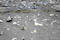
O.K. We're there, and we might as well start at the bottom and work up.
I've cropped an area of slabs at the base of the section and assigned working names so we can easily refer to them. So, can some of the field geologists give the non-geos among us a description of the types they see and list things they could be?
For example, to my untutored eye, the rocks El over to Ward represent a group of similar layers. Are they different in some significant way from the slabs Darby and Bernard just above? Is the upper layer likely to be of different origin or makeup? Obviously we don't have spectrometry now, so this is a visual-only exercise. Have we seen anything even remotely related to HP in Gusev so far? C'mon, rockhounds! We're all ears!  P.S. Steelers by 3 -------------------- My Grandpa goes to Mars every day and all I get are these lousy T-shirts!
|
|
|
|
|
|
|
Feb 6 2006, 07:02 PM
Post
#3
|
|
|
Member Group: Members Posts: 252 Joined: 27-April 05 Member No.: 365 |
Ok, the 'Going to Home Plate' thread is getting a bit long for me, so I thought I start a new topic now that we are 'there'.
I'm thinking that the MER team may already be contemplating ways to either ride out winter at HP/PM or how to at least extend their stay further into winter (perhaps 'Island hopping' thru north-facing slopes between HP and McCool Hill when they do leave). If they decide to stay, they might do the top of HP early on, then more of the north-facing perimeter deeper in the winter, then hop around to the north side of PM? |
|
|
|
|
Feb 6 2006, 07:12 PM
Post
#4
|
|
 Member Group: Members Posts: 723 Joined: 13-June 04 Member No.: 82 |
|
|
|
|
|
Feb 6 2006, 07:14 PM
Post
#5
|
|
|
Member Group: Members Posts: 252 Joined: 27-April 05 Member No.: 365 |
Oops, sorry, didn't spot that one!
|
|
|
|
|
Feb 6 2006, 07:15 PM
Post
#6
|
|
 Senior Member Group: Moderator Posts: 3431 Joined: 11-August 04 From: USA Member No.: 98 |
Check out the view out "to sea", as it were, from our position next to Home Plate. Yes, I know, I shouldn't say "out to sea" because the Martian Tricorder crowd will take me seriously, but I just can't help myself, the view is so evocative of a bay or something
 The view is due West by the way, 90 degrees wide. The view is due West by the way, 90 degrees wide.Edit: Oops, I guess we should go with the other thread, although I like the title of this one better. |
|
|
|
|
Feb 6 2006, 07:25 PM
Post
#7
|
|
|
Member Group: Members Posts: 252 Joined: 27-April 05 Member No.: 365 |
And the atmosphere is clearing a bit, I think!
|
|
|
|
|
Feb 6 2006, 07:44 PM
Post
#8
|
|
|
Member Group: Members Posts: 242 Joined: 21-December 04 Member No.: 127 |
The granular lower level intrigues me. Could be an ashfall layer, or we could be seeing grain size differences based on water velocity.
To go way, way out on a limb, there seems to be some periodicity within the coarse layer. Perhaps a series of flooding events? Above it is the finer-grained material...perhaps lacrustine sediments overlaying the initial coarse material following the water filling the basin? |
|
|
|
|
Feb 6 2006, 08:34 PM
Post
#9
|
|
|
Senior Member Group: Members Posts: 1229 Joined: 24-December 05 From: The blue one in between the yellow and red ones. Member No.: 618 |
QUOTE (gpurcell @ Feb 6 2006, 09:44 AM) The granular lower level intrigues me. Could be an ashfall layer, or we could be seeing grain size differences based on water velocity. To go way, way out on a limb, there seems to be some periodicity within the coarse layer. Perhaps a series of flooding events? Above it is the finer-grained material...perhaps lacrustine sediments overlaying the initial coarse material following the water filling the basin?  Thanx. I assume the entire Steelers backfield (sorry about the mixing of sports - Is this, by the way, the outcrop dubbed Gibson ?), is float that has fallen from above, so the El - Ward line is the base of this section. From this distance (When is Explo./JPL going to release today's photos??) the granular layer seems to have shadowed interstices (sorry I don't speak good Geo ). Would that favor a 'scoriaceous' kind of ashfall over a lacustrine gravel bed? Can we put any time constraints on this section? Is it less than a million years of accumulation, or given the nature of Mars could it be almost any duration? (Insert emoticon for sitting-at-your-feet-with-rapt-attention) -------------------- My Grandpa goes to Mars every day and all I get are these lousy T-shirts!
|
|
|
|
|
Feb 6 2006, 09:15 PM
Post
#10
|
|
|
Senior Member Group: Members Posts: 2998 Joined: 30-October 04 Member No.: 105 |
Just off the top of my head: the reason Spirit needs to be on a north-facing slope in Winter is that the Sun moves into the northern sky and the solar panels need to be tilted northward to keep them aligned with the Sun. FWIW, at 14 degrees south latitude the Sun will be no higher than 53* above the northern horizon.
But since the Sun moves NorthEast to due North to NorthWest, it the panels need to be oriented NE in the morning, N at noon and NW in the afternoon, so it seems that it could add a northwest-biased tilt in the afternoon for optimum solar output. That NW slope would be easily obtainable on the NW slope of McCool Hill, which could expand the envelope of possible paths. It will be interesting to see how the mission planners do this Winter. --Bill -------------------- |
|
|
|
|
Feb 6 2006, 09:21 PM
Post
#11
|
||
 Senior Member Group: Members Posts: 1083 Joined: 19-February 05 From: Close to Meudon Observatory in France Member No.: 172 |
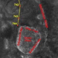
I hope we will have some time also to climb on top of Home Plate. Here are the names I gave to its 3 major albedo structures seen from orbit : a tribute much deserved to the 3 Home Plate discoverers : Dr. Nathalie Cabrol and Dr. Edmond Grin, not forgetting Gilles Dawidowicz, their intern student, who pintpointed Home Plate's interest from the very beginning ! Links : http://www.unmannedspaceflight.com/index.p...indpost&p=38492 http://www.unmannedspaceflight.com/index.p...indpost&p=38541
Attached thumbnail(s)
|
|
|
|
|
|
|
Feb 6 2006, 10:46 PM
Post
#12
|
|
|
Member Group: Members Posts: 713 Joined: 30-March 05 Member No.: 223 |
hand-colorized Sol 744 "Home Plate" panorama and Sol 743 navcam "El-Dorado Looking Back" Navcam-Panorama:
  (as always, those colors only reflect my subjective vision of the otherwise b/w landscape and may be way off the "true" spectrum ... 
|
|
|
|
|
Feb 6 2006, 11:04 PM
Post
#13
|
|
|
Member Group: Members Posts: 548 Joined: 19-March 05 From: Princeton, NJ, USA Member No.: 212 |
QUOTE (Nirgal @ Feb 6 2006, 10:46 PM) hand-colorized Sol 744 "Home Plate" panorama and Sol 743 navcam "El-Dorado Looking Back" Navcam-Panorama: Bernhard, these are fantastic and puts it all in perspective that HP has suffered an extremely violent event(s). And the layering on the right will I hope be an early target before climbing up as well as the richly layered areas and tire like tracks towards the left. this is a dream come true for all. Not surprisingly, SS sure was fast this time with an update ken |
|
|
|
|
Feb 6 2006, 11:16 PM
Post
#14
|
|
|
Member Group: Members Posts: 548 Joined: 19-March 05 From: Princeton, NJ, USA Member No.: 212 |
QUOTE (vikingmars @ Feb 6 2006, 09:21 PM) I hope we will have some time also to climb on top of Home Plate.Here are the names I gave to its 3 major albedo structures seen from orbit : a tribute much deserved to the 3 Home Plate discoverers : Dr. Nathalie Cabrol and Dr. Edmond Grin, not forgetting Gilles Dawidowicz, their intern student, who pintpointed Home Plate's interest from the very beginning ! Links : Olivier yeah I cant imagine the MER team not climbing on top unless there is no safe path and thanks for the backgroud on HP discoverers. I had missed that earlier and just checked out those illuminating presentations ken |
|
|
|
|
Feb 6 2006, 11:17 PM
Post
#15
|
|
 Member Group: Members Posts: 267 Joined: 5-February 06 Member No.: 675 |
QUOTE (mars loon @ Feb 6 2006, 11:04 PM) Bernhard, these are fantastic and puts it all in perspective that HP has suffered an extremely violent event(s).... ken Ken, The shards of shattered rock need not indicate extremely violent event(s). They look just like the kind of fragments one finds at the foot of mesas in Northern Arizona. The (admittedly uniformitarian) consensus is that those are the result of slow processes in which pieces of rock broke off, fell, shattered, and tumbled down the slope. I suspect similar processes took place at Home Plate. Steve |
|
|
|
|

|
Lo-Fi Version | Time is now: 19th April 2024 - 07:39 PM |
|
RULES AND GUIDELINES Please read the Forum Rules and Guidelines before posting. IMAGE COPYRIGHT |
OPINIONS AND MODERATION Opinions expressed on UnmannedSpaceflight.com are those of the individual posters and do not necessarily reflect the opinions of UnmannedSpaceflight.com or The Planetary Society. The all-volunteer UnmannedSpaceflight.com moderation team is wholly independent of The Planetary Society. The Planetary Society has no influence over decisions made by the UnmannedSpaceflight.com moderators. |
SUPPORT THE FORUM Unmannedspaceflight.com is funded by the Planetary Society. Please consider supporting our work and many other projects by donating to the Society or becoming a member. |
|