Rev 160 Titan monitoring, Recent change in Senkyo |

  |
Rev 160 Titan monitoring, Recent change in Senkyo |
 Jan 25 2012, 09:23 AM Jan 25 2012, 09:23 AM
Post
#1
|
||
|
Member  Group: Members Posts: 699 Joined: 1-April 08 From: Minnesota ! Member No.: 4081 |
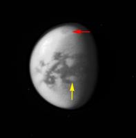
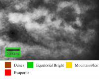
Rev 160 http://www.ciclops.org/view/7051/Rev160 view of Senkyo region appears to be showing less bright spot albedo change (yellow arrow) than 2 months ago. Image is from quite a distance however (3.2M km). Kraken in the north (red arrow) appears to have a brighter rim surrounding the darker sea, perhaps an artifact of my image processing. edit: sorry for the typo in the topic description! (fixed - Mod)
|
|
 |
 
|
|
|
Jan 25 2012, 10:13 AM
Post
#2
|
|
|
Senior Member Group: Members Posts: 3516 Joined: 4-November 05 From: North Wales Member No.: 542 |
I'm pretty sure the relatively bright 'halo' around Kraken Mare is real. Certainly it has been discussed before. I think Juramike had some ideas. I also think it's been mentioned in the literature. (Sorry I don't have references handy.) Anyhow it would be interesting to have people's latest thoughts on this.
|
|
|
|
|
Jan 29 2012, 05:47 AM
Post
#3
|
||
 Member Group: Members Posts: 131 Joined: 30-August 06 From: Moscow, Idaho Member No.: 1086 |
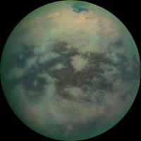
QUOTE (ngunn @ Jan 25 2012, 04:13 AM)  I'm pretty sure the relatively bright 'halo' around Kraken Mare is real. Certainly it has been discussed before. I think Juramike had some ideas. I also think it's been mentioned in the literature. (Sorry I don't have references handy.) Anyhow it would be interesting to have people's latest thoughts on this. Ring around Kraken isn't in the literature yet. VIMS T67 attached. Its spectrum, location, and morphology are consistent with evaporite. - Jason
Attached thumbnail(s)
|
|
|
|
|
|
|
Jan 29 2012, 07:57 AM
Post
#4
|
|
|
Senior Member Group: Members Posts: 3516 Joined: 4-November 05 From: North Wales Member No.: 542 |
Very interesting! That great image clearly shows the bright halo is most prominent at the heads of the southern bays whereas the capes between are relatively halo-free. Oh for some radar coverage of those bays to confirm that their shores are indeed smoother and more gently shelving.
|
|
|
|
|
Jan 29 2012, 08:19 AM
Post
#5
|
||
|
Member Group: Members Posts: 699 Joined: 1-April 08 From: Minnesota ! Member No.: 4081 |
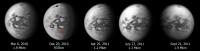
Yes fascinating. Kraken and its evaporative ring (black arrow) have been relatively stable over the 2010-11 period at least in ISS images (see below). The ISS ring appears more uniform and continuous around Kraken. Are the very bright portions of the VIMS image evaporite or clouds hugging the shoreline???
That small Senkyo area affected by the arrow storm (red arrow) went from a dark patch to a bright spot over the Dec 2010 to Sept 2011 time period. I would presume this might be an evaporite as well. Jason, is there a post-arrow storm image VIMS image of Senkyo covering the same area as that neat April 2010 pre-storm image you have posted above ?
|
|
|
|
|
|
|
Jan 29 2012, 08:11 PM
Post
#6
|
|
 Senior Member Group: Moderator Posts: 2785 Joined: 10-November 06 From: Pasadena, CA Member No.: 1345 |
(...keeping quiet until the LPSC abstracts publish on Friday...)
-------------------- Some higher resolution images available at my photostream: http://www.flickr.com/photos/31678681@N07/
|
|
|
|
|
Feb 3 2012, 10:06 PM
Post
#7
|
|
|
Member Group: Members Posts: 131 Joined: 30-August 06 From: Moscow, Idaho Member No.: 1086 |
I note that based on your arrow this change appears not occur within Senkyo, but rather within the newly named Yalaing Terra.
- Jason |
|
|
|
|
Feb 3 2012, 10:34 PM
Post
#8
|
|
|
Senior Member Group: Members Posts: 3516 Joined: 4-November 05 From: North Wales Member No.: 542 |
Is this the absract that relates to this discussion?
http://www.lpi.usra.edu/meetings/lpsc2012/pdf/2762.pdf |
|
|
|
|
Feb 4 2012, 12:49 AM
Post
#9
|
|
|
Member Group: Members Posts: 699 Joined: 1-April 08 From: Minnesota ! Member No.: 4081 |
"I note that based on your arrow this change appears not occur within Senkyo, but rather within the newly named Yalaing Terra."
- Jason Thanks for the proper name! Yes Yalaing Terra is what I had been referring to as Senkyo or South of Senkyo or S Senkyo since noting the change in December of 2010. http://www.unmannedspaceflight.com/index.php?showtopic=6829 The center of this region became a dark albedo post arrow-storm that gradually brightened and persisted as bright throughout most of 2011 (now fading a bit towards its pre-arrow storm albedo). The grid I made last year matches the official IAU coordinates of Yalaing Terra. The link below shows the projected position of the arrow-storm directly over this terra! http://www.unmannedspaceflight.com/index.p...st&id=23524 The change over the last year has been interesting to follow: http://www.unmannedspaceflight.com/index.p...st&id=26004 and now its interesting to read of the possible mechanisms of such changes in your LPSC abstract Nigel has highlighted above! |
|
|
|
|
Feb 8 2012, 07:37 PM
Post
#10
|
|
|
Member Group: Members Posts: 131 Joined: 30-August 06 From: Moscow, Idaho Member No.: 1086 |
QUOTE (ngunn @ Feb 3 2012, 04:34 PM) Is this the absract that relates to this discussion? http://www.lpi.usra.edu/meetings/lpsc2012/pdf/2762.pdf Yup. I note that these days the IAU only likes to name areas that require names in order to be referred to in a peer-reviewed scientific paper. - Jason |
|
|
|
|
Nov 7 2013, 10:43 PM
Post
#11
|
|
|
Member Group: Members Posts: 131 Joined: 30-August 06 From: Moscow, Idaho Member No.: 1086 |
QUOTE (Jason W Barnes @ Feb 8 2012, 01:37 PM) Yup. I note that these days the IAU only likes to name areas that require names in order to be referred to in a peer-reviewed scientific paper. BTW, the joint VIMS/ISS paper about the surface changes is out in the new Open Access journal Planetary Science. - VIMS Jason |
|
|
|
|
Nov 9 2013, 03:41 AM
Post
#12
|
|||
|
Member Group: Members Posts: 699 Joined: 1-April 08 From: Minnesota ! Member No.: 4081 |
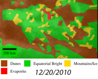
Thanks Jason for the link to your paper, a very readable and comprehensive analysis of the surface changes of specific regions affected by the massive arrow storm of Sept 2010. The discussion of the VIMS versus ISS imaging changes and the constraints the observations place on what the storm most likely did to Titans surface are outstanding.
My favorite region analyzed was (of course) Yalaing Terra. Borrowing Fig2 from the paper and using the tiff file PDS version of the Dec 20 2010 image showing the earliest changes in the area, one is struck how the larger and moderately darkened central area seems to nestle nicely into the geography perhaps suggesting some ponding/playa formation.
|
||
|
|
|
||
|
Nov 13 2013, 04:38 AM
Post
#13
|
|
|
Member Group: Members Posts: 131 Joined: 30-August 06 From: Moscow, Idaho Member No.: 1086 |
QUOTE (titanicrivers @ Nov 8 2013, 09:41 PM) Borrowing Fig2 from the paper and using the tiff file PDS version of the Dec 20 2010 image showing the earliest changes in the area, one is struck how the larger and moderately darkened central area seems to nestle nicely into the geography perhaps suggesting some ponding/playa formation. Nice! It's too bad you can't put an animated .gif like that into a paper. Especially in this kind of case with changes it would just be WAY easier to understand than a bunch of pictures thrown together like I ended up having to do  - VIMS Jason |
|
|
|
|
Nov 24 2013, 10:31 PM
Post
#14
|
||
|
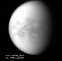
Member Group: Members Posts: 699 Joined: 1-April 08 From: Minnesota ! Member No.: 4081 |
The PDS version of the jpeg raw image N00175714 is incorporated in the figure below. That image taken in Sep 2011 showed the remarkable transformation of central Yalaing terra from ISS dark to ISS bright . Once again the geographic map and geomorphology units are from Fig 2 of the Barnes et al paper cited above.
|
|
|
|
|
|
|

|
Lo-Fi Version | Time is now: 23rd April 2024 - 08:04 PM |
|
RULES AND GUIDELINES Please read the Forum Rules and Guidelines before posting. IMAGE COPYRIGHT |
OPINIONS AND MODERATION Opinions expressed on UnmannedSpaceflight.com are those of the individual posters and do not necessarily reflect the opinions of UnmannedSpaceflight.com or The Planetary Society. The all-volunteer UnmannedSpaceflight.com moderation team is wholly independent of The Planetary Society. The Planetary Society has no influence over decisions made by the UnmannedSpaceflight.com moderators. |
SUPPORT THE FORUM Unmannedspaceflight.com is funded by the Planetary Society. Please consider supporting our work and many other projects by donating to the Society or becoming a member. |
|