Opportunity Route Map |

  |
Opportunity Route Map |
 Aug 10 2010, 02:02 PM Aug 10 2010, 02:02 PM
Post
#2791
|
|
|
Senior Member  Group: Moderator Posts: 4279 Joined: 19-April 05 From: .br at .es Member No.: 253 |
|
 |
 
|
|
Aug 10 2010, 05:48 PM
Post
#2792
|
|
 Senior Member Group: Members Posts: 1887 Joined: 20-November 04 From: Iowa Member No.: 110 |
I have a suggestion for the daily updates: recenter the mini-maps so there is enough area beyond the current position to guess where the next stop will be.
|
|
|
|
|
Aug 10 2010, 06:05 PM
Post
#2793
|
|
 Senior Member Group: Members Posts: 4246 Joined: 17-January 05 Member No.: 152 |
Maybe it'd be easier for anyone who wants to predict the next stop, to do that using Parker's official route maps, which are at higher resolution, or other higher resolution orbital images that have been posted?
|
|
|
|
|
Aug 10 2010, 09:12 PM
Post
#2794
|
||
 Senior Member Group: Admin Posts: 4763 Joined: 15-March 05 From: Glendale, AZ Member No.: 197 |
Ever since Eduardo began including the Google Mars kml, as well as the HIRISE overlays, that has really been the optimum way to get a good look at where we are, where we've been, and where we are going. Not sure why another image would be necessary.
Guess away ...
Attached thumbnail(s)
-------------------- If Occam had heard my theory, things would be very different now.
|
|
|
|
|
|
|
Aug 10 2010, 09:30 PM
Post
#2795
|
|
|
Senior Member Group: Moderator Posts: 4279 Joined: 19-April 05 From: .br at .es Member No.: 253 |
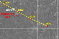
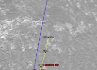
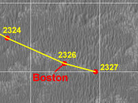
QUOTE (alan @ Aug 10 2010, 07:48 PM)  I have a suggestion for the daily updates: recenter the mini-maps so there is enough area beyond the current position to guess where the next stop will be. Let's have a try. I'm usually keeping the "mini-maps" small (< 200x200pix) to avoid the automatic resizing done by the forum software, e.g. compare the last post (sol 2326) with the previous one. The problem is that with these 70m+ drives we loose a lot of context if the tiny image is centered on the last position because there's slightly more then a single drive on the picture. I can try making these pictures a little bit bigger (e.g. 400x200) but not too much since I don't want to be posting "big" (100KB+) attachments every day. Of course, I'm speaking about the map@1m/pix. If anybody wants a higher resolution picture the answer already is on the two previous posts. 
|
|
|
|
|
Aug 11 2010, 07:00 AM
Post
#2796
|
|
|
Senior Member Group: Members Posts: 1887 Joined: 20-November 04 From: Iowa Member No.: 110 |
Oh well, I guess I'm the only one who thinks where we are going next is the more interest context than where we were. Surprising, because I don't remember anyone fighting over for the rear facing seats of the station wagon when we took long family trips when I was a kid.
|
|
|
|
|
Aug 11 2010, 07:10 AM
Post
#2797
|
|
 Senior Member Group: Admin Posts: 3108 Joined: 21-December 05 From: Canberra, Australia Member No.: 615 |
alan, I think that after 6.5 years of Tesh's maps keeping us in touch with the journey, they have served us well and provide the quick update for following the rover's course.
There are more detailed maps available of the 'road ahead' that he makes available now and again and as has been said before in this thread "it's fun to speculate what the next stop might be, but you can never second guess what might be just around the next corner for these vehicles". One thing I do is take the full map that he provides and then take each daily update and paste that onto the big version. Then I can following along and look ahead. Of course you can always take a look at the now marvellously detailed maps on the Rover's own website or download the highest resolution maps from the HiRise website. OK, so now let's settle down in the back seat again and let mom and dad get back to the driving. 
|
|
|
|
|
Aug 11 2010, 09:57 AM
Post
#2798
|
||
|
Senior Member Group: Moderator Posts: 4279 Joined: 19-April 05 From: .br at .es Member No.: 253 |
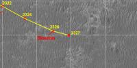
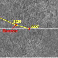
Ok, here's the update corresponding to sol 2327. Let's see how is looks like...
   Route_Map_Sol2327.kml ( 54.97K )
Number of downloads: 387
Route_Map_Sol2327.kml ( 54.97K )
Number of downloads: 387To be fair, I like alan's idea but the visual result on the post is not good since you must open the attachment to really see the details. From the three thumbnails ("mini-maps") above, my choice is still the rightmost one. It is still possible to see the leftmost picture without the automatic resizing but it means I would have to host the thumbnails on a different site and that's definitely not an option. |
|
|
|
|
|
|
Aug 11 2010, 11:43 AM
Post
#2799
|
|
|
Senior Member Group: Members Posts: 1887 Joined: 20-November 04 From: Iowa Member No.: 110 |
So what we have is a case of 1)looks like a route map, 2)shows the terrain visible in the in the drive direction mosaic, 3)is small enough to avoid resizing; pick any two. Oh well.
|
|
|
|
|
Aug 11 2010, 01:37 PM
Post
#2800
|
|
|
Solar System Cartographer Group: Members Posts: 10157 Joined: 5-April 05 From: Canada Member No.: 227 |
I have no problem with having to enlarge the reduced version.
Phil -------------------- ... because the Solar System ain't gonna map itself.
Also to be found posting similar content on https://mastodon.social/@PhilStooke Maps for download (free PD: https://upload.wikimedia.org/wikipedia/comm...Cartography.pdf NOTE: everything created by me which I post on UMSF is considered to be in the public domain (NOT CC, public domain) |
|
|
|
|
Aug 11 2010, 02:55 PM
Post
#2801
|
|
|
Member Group: Members Posts: 507 Joined: 10-September 08 Member No.: 4338 |
My choice is the one on the left, second choice the one in the middle. The additional context is useful for locating the area within the larger map posted at JPL, which is difficult with the one on the right.
|
|
|
|
|
Aug 11 2010, 03:04 PM
Post
#2802
|
|
 Member Group: Members Posts: 699 Joined: 3-December 04 From: Boulder, Colorado, USA Member No.: 117 |
I also vote for the one on the left. Nice to have a bit more context, and the one extra mouse click required is not a big deal. But it's fabulous any way you do it...
John |
|
|
|
|
Aug 11 2010, 03:12 PM
Post
#2803
|
|
|
Founder Group: Chairman Posts: 14432 Joined: 8-February 04 Member No.: 1 |
And ET gets a guilt-free pass for attachment size, so I vote for the 400x200 as well
|
|
|
|
|
Aug 11 2010, 03:50 PM
Post
#2804
|
|
 Administrator Group: Admin Posts: 5172 Joined: 4-August 05 From: Pasadena, CA, USA, Earth Member No.: 454 |
I'm just piping up to say that I am in such a hurry when reading that I actually prefer not having to click to enlarge -- I just sort of scroll back and mentally mosaic the images to see where we've come from and figure I'll know where we're going when we've gone there. Which is to say I like what Tesh has been doing. But really what I like most of all is the fact that Tesh provides these maps in any form!!
-------------------- My website - My Patreon - @elakdawalla on Twitter - Please support unmannedspaceflight.com by donating here.
|
|
|
|
|
Aug 11 2010, 04:07 PM
Post
#2805
|
|
 Member Group: Members Posts: 568 Joined: 20-April 05 From: Silesia Member No.: 299 |
I vote for the 400x200 too, context is very useful.
-------------------- Free software for planetary science (including Cassini Image Viewer).
http://members.tripod.com/petermasek/marinerall.html |
|
|
|
|

|
Lo-Fi Version | Time is now: 4th May 2024 - 09:40 AM |
|
RULES AND GUIDELINES Please read the Forum Rules and Guidelines before posting. IMAGE COPYRIGHT |
OPINIONS AND MODERATION Opinions expressed on UnmannedSpaceflight.com are those of the individual posters and do not necessarily reflect the opinions of UnmannedSpaceflight.com or The Planetary Society. The all-volunteer UnmannedSpaceflight.com moderation team is wholly independent of The Planetary Society. The Planetary Society has no influence over decisions made by the UnmannedSpaceflight.com moderators. |
SUPPORT THE FORUM Unmannedspaceflight.com is funded by the Planetary Society. Please consider supporting our work and many other projects by donating to the Society or becoming a member. |
|