New maps of Mimas, Tethys and Iapetus |

 Unmanned Spaceflight.com > Outer Solar System > Saturn > Cassini Huygens > Cassini's ongoing mission and raw images
  |
New maps of Mimas, Tethys and Iapetus |
 Jan 19 2009, 12:25 PM Jan 19 2009, 12:25 PM
Post
#1
|
|
 Senior Member  Group: Members Posts: 1729 Joined: 3-August 06 From: 43° 35' 53" N 1° 26' 35" E Member No.: 1004 |
See the paper "High-resolution Atlases of Mimas, Tethys, and Iapetus derived from Cassini-ISS images" in the latest issue of Planetary and Space Science (available for free)
|
 |
 
|
|
Oct 3 2009, 02:50 PM
Post
#2
|
||
 Senior Member Group: Members Posts: 1628 Joined: 5-March 05 From: Boulder, CO Member No.: 184 |
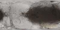
Here is an updated map of Iapetus - my first in about a year. It has an image added from Sept 2009, and the main area of Saturnshine imagery has been reworked. Color is also a bit better I think.
Full resolution here: http://laps.noaa.gov/albers/sos/sos.html#IAPETUS That's the latest! Steve |
|
|
|
|
|
|

|
Lo-Fi Version | Time is now: 25th April 2024 - 12:08 AM |
|
RULES AND GUIDELINES Please read the Forum Rules and Guidelines before posting. IMAGE COPYRIGHT |
OPINIONS AND MODERATION Opinions expressed on UnmannedSpaceflight.com are those of the individual posters and do not necessarily reflect the opinions of UnmannedSpaceflight.com or The Planetary Society. The all-volunteer UnmannedSpaceflight.com moderation team is wholly independent of The Planetary Society. The Planetary Society has no influence over decisions made by the UnmannedSpaceflight.com moderators. |
SUPPORT THE FORUM Unmannedspaceflight.com is funded by the Planetary Society. Please consider supporting our work and many other projects by donating to the Society or becoming a member. |
|