Unmanned landing sites from LRO, Surveyors, Lunas, Lunakhods and impact craters from hardware impacts |

  |
Unmanned landing sites from LRO, Surveyors, Lunas, Lunakhods and impact craters from hardware impacts |
 Mar 31 2012, 05:22 PM Mar 31 2012, 05:22 PM
Post
#121
|
|
 Senior Member  Group: Members Posts: 1729 Joined: 3-August 06 From: 43° 35' 53" N 1° 26' 35" E Member No.: 1004 |
even before these images were released, the Lavochkin website was stating that Luna 23 had landed with too great a horizontal speed and on an unfavorable slope and toppled over, damaging the drill and depressurizing
|
 |
 
|
|
Apr 1 2012, 12:03 PM
Post
#122
|
|
|
Solar System Cartographer Group: Members Posts: 10159 Joined: 5-April 05 From: Canada Member No.: 227 |
Interesting... but I never heard that stated before. It was always just 'landed too hard' or something similar. I wonder where this comes from.
Phil -------------------- ... because the Solar System ain't gonna map itself.
Also to be found posting similar content on https://mastodon.social/@PhilStooke Maps for download (free PD: https://upload.wikimedia.org/wikipedia/comm...Cartography.pdf NOTE: everything created by me which I post on UMSF is considered to be in the public domain (NOT CC, public domain) |
|
|
|
|
Sep 7 2012, 07:08 PM
Post
#123
|
|
|
Senior Member Group: Members Posts: 1729 Joined: 3-August 06 From: 43° 35' 53" N 1° 26' 35" E Member No.: 1004 |
|
|
|
|
|
Oct 13 2012, 08:36 AM
Post
#124
|
|
|
Senior Member Group: Members Posts: 1729 Joined: 3-August 06 From: 43° 35' 53" N 1° 26' 35" E Member No.: 1004 |
I have been reading the article "Declassifying the Space Race - part 2" in the October issue of Aerospace America (http://www.aerospaceamerica.org/Pages/TableOfContents.aspx)
interesting things: apparently the National Security Agency had means of intercepting the full telemetry of some Soviet probes including Luna 18 and 20. A detailed timeline of events concerning the latter is given, and as to the former, the NSA apparently used a tracking software fed with Soviet tracking data (!) the NSA also wrote: "The landing site of Luna 20 is very near that of Luna 18 which crashed to the surface at 03-43N, 056-30E on 11 September 1971". the author notes that this differs from the official impact point, which is given (see for ex http://www.laspace.ru/rus/luna18.html) as 3° 34' N, 56° 30' E. and adds "To date, amateur astronomers using the official Russian location data have been unable to find Luna 18's crash site via NASA's photographic archives from its Lunar Reconnaissance Orbiter program." I suspect that this is just a typing error in the NSA report, but I was wondering: do LRO imagery of 3° 43' N, 56° 30' E exist? |
|
|
|
|
Oct 14 2012, 02:13 AM
Post
#125
|
|
 Member Group: Members Posts: 236 Joined: 5-June 08 From: Udon Thani Member No.: 4185 |
QUOTE (Paolo @ Oct 13 2012, 04:36 PM)  I suspect that this is just a typing error in the NSA report, but I was wondering: do LRO imagery of 3° 43' N, 56° 30' E exist? LROC image search http://wms.lroc.asu.edu/lroc/search gives me more then 300 possible images for this location, so it is covered by LRO. http://wms.lroc.asu.edu/lroc/view_lroc/LRO....0/M192588983LC should cover it, afaik, but there are far more options. Just like you, however, I suspect this is a typing error in the NSA report, and I doubt whether they know any better then the Soviets where Luna 18 ended up. The Lavochin description on the website you stated earlier differs quite strongly from several other publications and gives the impression that Luna 18 lost comms much earlier in the descent then previously was stated, making it more likely it completely smashed to smithereens and all we might ever find of it is a crater. As I read my translation from the Lavochin state, Luna 18 suffered engine/stabilisation problems already during LOI due to a blocking in the oxidizer supply to one of the engines controlling the pitch. Due to this error, LOI was cut short by 15 seconds and it ended up in the wrong orbit altogether, loosing a lot of extra fuel in attempts to compensate. When finally a landing was attempted, it lost stabilisation and crashed. What confuses me however is that this sounds very much like all descriptions of Luna 15, while I've never seen any other publication stating that Luna 18 ended up the wrong orbit after LOI.. Other publications and statements often seem to suggest that Luna 18 either lost radar-lock or ran out of fuel at very low altitude (some state after the vernier engines took over on final approach, which is at aprox. 20 mtrs above the surface). If that is true, we might find some wreckage aka Luna 23 and the candidate Phil Stooke earlier pointed to seems most likely. If the Lavochin site is correct (and they are the ones who should know, I would say) then there were already so many problems just steering it in the correct orbit and with the thing loosing stabilisation early in the burn, it might have come down anywhere and the coordinates they give is probably only the best guess or the intended location. I hope someone finds it, but it's a big area to search and lots of stones and craters down there. |
|
|
|
|
Oct 14 2012, 04:19 AM
Post
#126
|
|
 Senior Member Group: Members Posts: 3419 Joined: 9-February 04 From: Minneapolis, MN, USA Member No.: 15 |
I would still like to see if there is any sign of Surveyor IV in Sinus Medii. The best co-ordinates for the intended landing site I can find are 0.4N and 1.33W.
Yeah, I know that if the solid retro exploded as it neared exhaustion the craft would have been too far up for anything truly recognizable to be left after the shrapnel hit the surface. But there is always that tiny chance that Surveyor IV actually completed its landing safely and the failure was simply with the comm system. I wonder if anyone has ever looked for either a landed Surveyor within the targeted footprint, or a set of craters where the pieces could have fallen...? -the other Doug -------------------- The trouble ain't that there is too many fools, but that the lightning ain't distributed right. -Mark Twain
|
|
|
|
|
Nov 9 2012, 01:26 PM
Post
#127
|
|
|
Rover Driver Group: Members Posts: 1015 Joined: 4-March 04 Member No.: 47 |
Interesting paper about Luna landers: http://www.sciencedirect.com/science/artic...3312003078?v=s5
|
|
|
|
|
Apr 8 2013, 06:10 PM
Post
#128
|
||
|
Solar System Cartographer Group: Members Posts: 10159 Joined: 5-April 05 From: Canada Member No.: 227 |
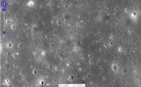
This is a possible site for the Apollo 14 LM ascent stage. It's the same dark spot which I posted a view of several years ago, but now in a better image. It is within a few km of the dark spot Ewen Whittaker thought might be the impact point but not exactly the same.
Phil
-------------------- ... because the Solar System ain't gonna map itself.
Also to be found posting similar content on https://mastodon.social/@PhilStooke Maps for download (free PD: https://upload.wikimedia.org/wikipedia/comm...Cartography.pdf NOTE: everything created by me which I post on UMSF is considered to be in the public domain (NOT CC, public domain) |
|
|
|
|
|
|
May 4 2013, 02:41 AM
Post
#129
|
|
 Newbie Group: Members Posts: 6 Joined: 28-April 13 Member No.: 6918 |
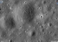
The most interesting object I found in my searches of the Moon.
Initially I thought it was Luna 13. I still can't get it out of my mind that it is some man made probe, what do you think? 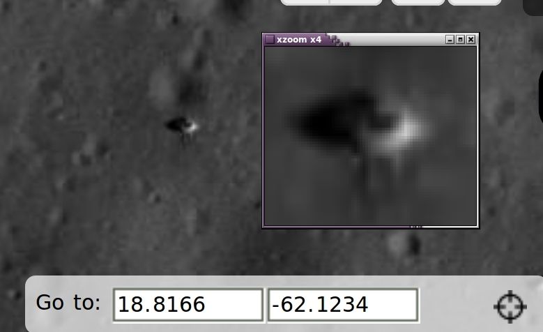
-------------------- "If you can't explain it simply, you don't understand it well enough"
- Albert Einstein |
|
|
|
|
May 4 2013, 10:01 AM
Post
#130
|
|
|
Member Group: Members Posts: 236 Joined: 5-June 08 From: Udon Thani Member No.: 4185 |
QUOTE (jasonjason @ May 4 2013, 10:41 AM) The most interesting object I found in my searches of the Moon. Definitely interesting and close to the expected position of Luna 13, but I wonder about the size, it seems to me somewhat too big. Remember the E6 landers were just 58 centimeters in diameter, and although the outfolded pedals make it slightly bigger that's still only very close to the maximum resolution of the LRO camera, in other words they won't be more then a few pixels at most and this object seems a lot larger. It clearly casts a shadow, so that might help also, if you know the sun-angle at the time the picture was taken, you can use that to calculate an estimate of the height of the object, see if this confirms with the E6 landers. And, finally, if this is Luna 13, you should be able to find more objects in the vicinity. The cruise-stage landed at very low speed and should have come down more or less intact in the vicinity of the lander (in fact, the cruise stage was considerably larger then the lander, you might find the cruise stage first, and then the lander, or the object you have found might be the cruise stage). On the panorama pictures from Luna 13 you can see some objects on the surface, and some of them seem to be part of the spacecraft itself, see if they match with your observation! Luna 13 is definitely making a chance to be found, I would guess. We know it landed on a relatively flat, featureless, plane with not many big stones or suchlike lying around, so provided there are sufficient shadows it should stand out. The small size of these landers is however what makes it so hard, they were really small and close to the limits of the LRO camera system. |
|
|
|
|
May 4 2013, 11:37 AM
Post
#131
|
|
|
Newbie Group: Members Posts: 6 Joined: 28-April 13 Member No.: 6918 |
Thanks for the input Geert,
I do have the NACS with the object and there is anothe object close by I will post them. Can you explain calculating sun angle to get size? I find it hard to measure using the measuring tool in ACT-REACT. -------------------- "If you can't explain it simply, you don't understand it well enough"
- Albert Einstein |
|
|
|
|
May 4 2013, 11:53 AM
Post
#132
|
|
|
Newbie Group: Members Posts: 6 Joined: 28-April 13 Member No.: 6918 |
Here are the NAC strips with the object.
I have already shown this object to Phil and he does not think that it is Luna 13, I agree but I can't get it out of my head that it is something man made, maybe an unknown probe no one said anything about. 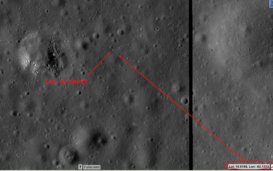 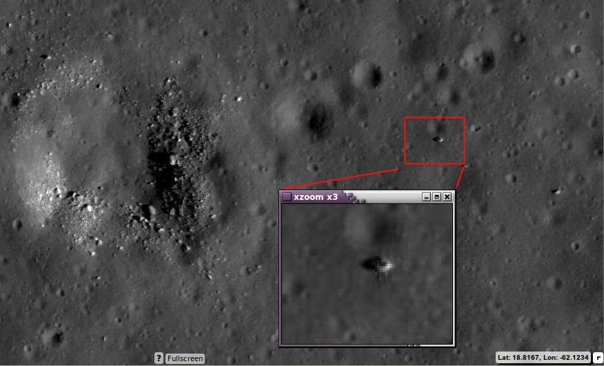 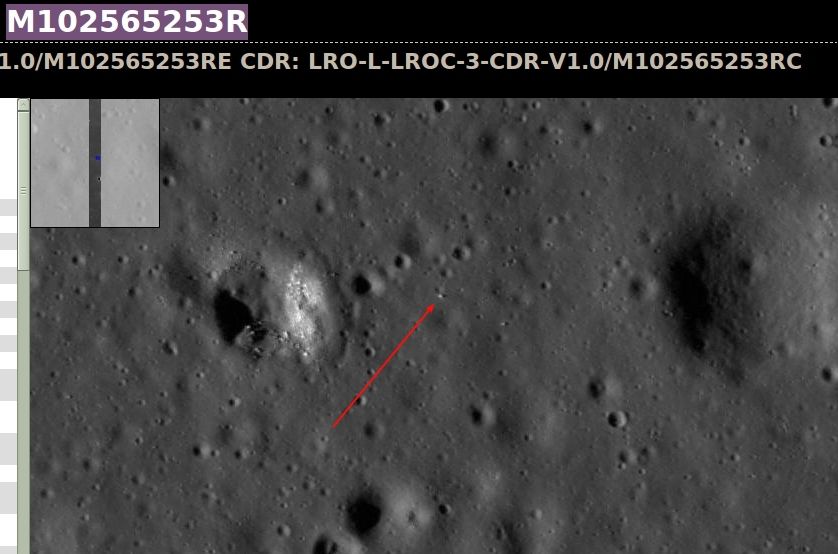 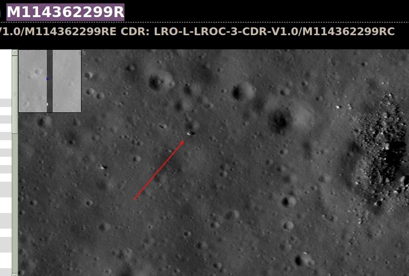 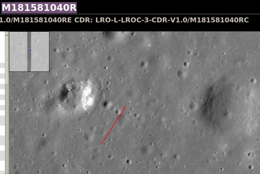 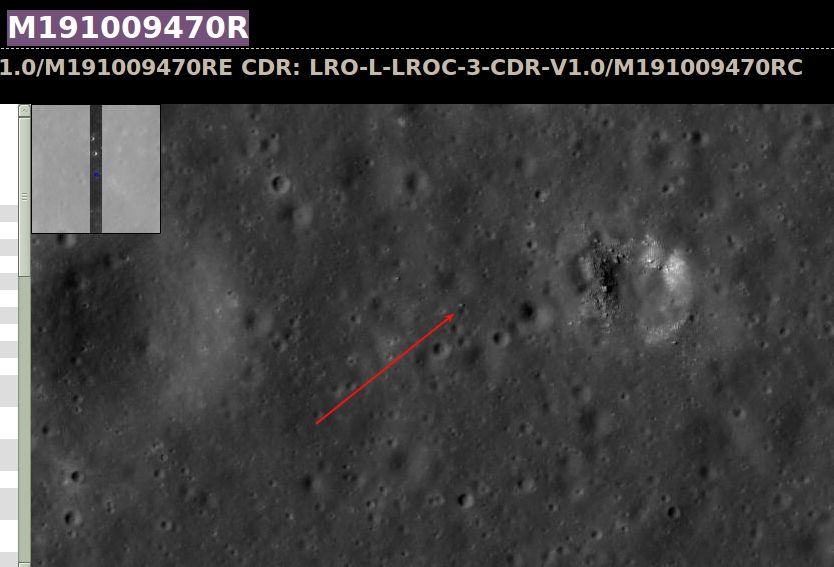 -------------------- "If you can't explain it simply, you don't understand it well enough"
- Albert Einstein |
|
|
|
|
May 4 2013, 01:18 PM
Post
#133
|
|
|
Solar System Cartographer Group: Members Posts: 10159 Joined: 5-April 05 From: Canada Member No.: 227 |
This is a very interesting object, but of course there is no other lander in the vicinity and the features around it do not match the pattern of craters imaged by Luna 13 (since they cover a much larger area than Luna 13 itself, they are going to be the deciding factor). So it has to be just a rock, but a very interesting rock. Note that the two lines extending from it are probably artifacts of the compression algorithm.
-------------------- ... because the Solar System ain't gonna map itself.
Also to be found posting similar content on https://mastodon.social/@PhilStooke Maps for download (free PD: https://upload.wikimedia.org/wikipedia/comm...Cartography.pdf NOTE: everything created by me which I post on UMSF is considered to be in the public domain (NOT CC, public domain) |
|
|
|
|
May 4 2013, 05:51 PM
Post
#134
|
|
|
Member Group: Members Posts: 149 Joined: 18-June 08 Member No.: 4216 |
Apart from the successful Luna 9 & 13, Lunas 7 and 8 also reached that part of the Moon, impacting
at high speed. According to NSSDC, Luna 7 impacted at 9.8 N, 47.8 W, while Luna 8 impacted at 9.1 N, 63.3 W. Impact speed would have been up to ~3 km/s, perhaps lower for Luna 8 if you believe one story that the retrorockets fired late. On the premise that metal does not completely vapourise under these conditions, there should be a couple of interesting debris-littered craters somewhere in the W part of the Ocean of storms. Tolis. |
|
|
|
|
May 4 2013, 10:23 PM
Post
#135
|
||
|
Solar System Cartographer Group: Members Posts: 10159 Joined: 5-April 05 From: Canada Member No.: 227 |
This is an image I sent to Jason which shows more what I would be looking for at the Luna 13 location. The arrow points to a small lump inside a crater which also contains another crater - the pattern of features imaged by Luna 13 according to the map drawn by Soviet scientists at the time. Looking towards the horizon the images suggest a very subdued larger crater north of the lander. So the general pattern seen here should be roughly what we would expect. This one is not quite right - some other small features nearby don't show up as I would expect. But it's pretty close. (we might also expect a bright blast pattern around the lander caused by its braking stage - as well as the stage itself crashed nearby)
Phil
-------------------- ... because the Solar System ain't gonna map itself.
Also to be found posting similar content on https://mastodon.social/@PhilStooke Maps for download (free PD: https://upload.wikimedia.org/wikipedia/comm...Cartography.pdf NOTE: everything created by me which I post on UMSF is considered to be in the public domain (NOT CC, public domain) |
|
|
|
|
|
|

|
Lo-Fi Version | Time is now: 8th May 2024 - 06:25 AM |
|
RULES AND GUIDELINES Please read the Forum Rules and Guidelines before posting. IMAGE COPYRIGHT |
OPINIONS AND MODERATION Opinions expressed on UnmannedSpaceflight.com are those of the individual posters and do not necessarily reflect the opinions of UnmannedSpaceflight.com or The Planetary Society. The all-volunteer UnmannedSpaceflight.com moderation team is wholly independent of The Planetary Society. The Planetary Society has no influence over decisions made by the UnmannedSpaceflight.com moderators. |
SUPPORT THE FORUM Unmannedspaceflight.com is funded by the Planetary Society. Please consider supporting our work and many other projects by donating to the Society or becoming a member. |
|