Post Conjunction: Santa Maria to Cape York, The Journey to 'Spirit Point' |

  |
Post Conjunction: Santa Maria to Cape York, The Journey to 'Spirit Point' |
 May 1 2011, 09:26 AM May 1 2011, 09:26 AM
Post
#271
|
|
|
Senior Member  Group: Moderator Posts: 4279 Joined: 19-April 05 From: .br at .es Member No.: 253 |
This month's MER Update by A.J.S. Rayl is online now. I've just started to read it and found this:
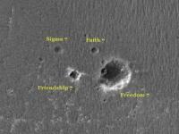
Today the rover is scheduled to drive on toward a grouping of several impact craters, named Freedom 7, Sigma 7, Faith 7, and Friendship 7, for the NASAs historic Mercury spacecraft. Edit: ... and this:  "Opportunity is turning into one of these active seniors who make the rest of us feel self-conscious," chuckled Callas. "Here's this little old rover zipping around up there every day, while we're saying to ourselves: 'I really need to do something more about my weight and getting a little more exercise.'" |
 |
 
|
|
May 1 2011, 10:16 AM
Post
#272
|
||
 The Poet Dude Group: Moderator Posts: 5551 Joined: 15-March 04 From: Kendal, Cumbria, UK Member No.: 60 |
Just been reading that too... another fantastic report, as usual...
Those newly-named craters...
-------------------- |
|
|
|
|
|
|
May 1 2011, 10:28 AM
Post
#273
|
|
|
Senior Member Group: Moderator Posts: 4279 Joined: 19-April 05 From: .br at .es Member No.: 253 |
I was just ready to post a GE snapshot with the actual crater names when I saw yours.
 Yep, that's the right assignment; Salley puts it very clear on the report. Today was another driving sol but I still can't get enough data to post a preliminary map update. With the currently available data (to us, outsiders) I can only tell it seems to be another looooong drive (+100m ?) so we might be right at the "Mercury crater field". |
|
|
|
|
May 1 2011, 12:56 PM
Post
#274
|
|
|
The Poet Dude Group: Moderator Posts: 5551 Joined: 15-March 04 From: Kendal, Cumbria, UK Member No.: 60 |
This was very interesting, I thought...
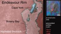
The course charted will take Opportunity up to Endeavour's Cape York by way of Botany Bay, Arvidson confirmed. "Botany Bay through CRISM data shows hydrated sulfates and it's an easier approach to the southern side of Cape York where the phyllosilicates are exposed." Sooooo, looks like Oppy will actually drive past Cape York then double back and roll up onto it from the south. They really want a look at that rubble-surrounded crater, don't they? Can't wait to see those pics, as at least one of the blocks is bigger than Oppy herself... New Cape York pic up on: http://roadtoendeavour.wordpress.com/2011/...te-to-cape-york -------------------- |
|
|
|
|
May 1 2011, 04:13 PM
Post
#275
|
|||
 Senior Member Group: Members Posts: 2173 Joined: 28-December 04 From: Florida, USA Member No.: 132 |
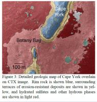
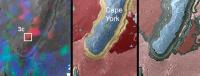
What confuses me is that the darker green that is labeled as "clay minerals" at Cape Tribulation is not seen at Cape York, while the significance of the lighter, yellowish green seen around Cape York and elsewhere is not mentioned. (Does it indicate a weaker signal, or phyllosilicates of different mineralogy?)
Neither this latest image or the previous image from http://www.planetary.brown.edu/pdfs/3954.pdf shows any phyllosilicate signal around the crater on the South tip of Cape York. Perhaps all that ejecta will just be blocks of basalt. In fact, I don't see any phyllosilicate signal at the South end of Cape York in the latest image, so I don't know where they intend to look. The ejecta doesn't look like a good bet to me but of course it would be a good idea to investigate the ejecta regardless of whether it contains phyllosilicates or not.
|
||
|
|
|
||
|
May 1 2011, 04:36 PM
Post
#276
|
|
 Senior Member Group: Members Posts: 4246 Joined: 17-January 05 Member No.: 152 |
There is newer CRISM data - see this post.
Fig 3 from that abstract shows a few small greenish spots on Cape York, though it doesn't say what the colour represents. One of the spots corresponds with the blocky crater Stu's been talking about. The text says there are possibly interesting signatures from Cape York itself. |
|
|
|
|
May 1 2011, 04:40 PM
Post
#277
|
|
|
Senior Member Group: Members Posts: 4246 Joined: 17-January 05 Member No.: 152 |
QUOTE (Tesheiner @ May 1 2011, 10:26 AM)  This month's MER Update by A.J.S. Rayl is online now. Another interesting bit is a description of the criss-crossy "darkened terrain" we drove through on 2581: QUOTE That drive put Opportunity in the middle of an intriguing, "inverted relief" terrain area. "It's an area about 60 meters wide that features fractured bedrock with material deposited by wind," Arvidson described. "It [appears] that a little bit of water coming through the fractures cemented the materials and then wind erosion took away the softer bedrock, leaving the fracture standing as high areas, so it's kind of inverted relief," he explained. The rover stopped to take in the sights with some Pancam and NavCam pictures of the terrain. "We'll probably have them down next week. They're not super high priority," said Arvidson.
|
|
|
|
|
May 1 2011, 06:01 PM
Post
#278
|
|
|
Senior Member Group: Members Posts: 4246 Joined: 17-January 05 Member No.: 152 |
QUOTE (Stu @ May 1 2011, 01:56 PM) "Botany Bay through CRISM data shows hydrated sulfates and it's an easier approach to the southern side of Cape York where the phyllosilicates are exposed." I'd just add one more point. I interpreted that quote differently. I read it "...it's an easier approach from the south end of Cape York to the region south of Cape York where the phyllosilicates are exposed." Ie, from the south end of CY they will be able to easily head south across Botany Bay towards Tribulation, where they know there are phyllosilicates. I don't think they're planning on phyllosilicates at CY, but any they do spot would be investigated, I'm sure. |
|
|
|
|
May 1 2011, 06:12 PM
Post
#279
|
||
|
Senior Member Group: Members Posts: 2173 Joined: 28-December 04 From: Florida, USA Member No.: 132 |
QUOTE (fredk @ May 1 2011, 11:36 AM) There is newer CRISM data... shows a few small greenish spots on Cape York, though it doesn't say what the colour represents. ... It looks to me like the green just represents craters, with no respect as to what materials are associated with them. While the text mentions "... the presence of Fe-Mg smectites in Cape Tribulation and perhaps even in Cape York.....", there is no indication of phyllosilicates in the diagram.
http://www.lpi.usra.edu/meetings/lpsc2011/pdf/2199.pdf (link indicated by fredk) |
|
|
|
|
|
|
May 2 2011, 03:08 AM
Post
#280
|
|
|
Senior Member Group: Members Posts: 1043 Joined: 17-February 09 Member No.: 4605 |
QUOTE (centsworth_II @ May 1 2011, 04:13 PM) In fact, I don't see any phyllosilicate signal at the South end of Cape York in the latest image, so I don't know where they intend to look. Actually the phyllosilicates at Cape York seem to originate with the ejecta from the now filled crater in the centre and were possibly dug out of a deeper, protected deposit by the impact. |
|
|
|
|
May 2 2011, 06:23 AM
Post
#281
|
||
 Senior Member Group: Members Posts: 2228 Joined: 1-December 04 From: Marble Falls, Texas, USA Member No.: 116 |
QUOTE (centsworth_II @ May 1 2011, 01:12 PM) It looks to me like the green just represents craters, with no respect as to what materials are associated with them. ... That geologic map has been used in a number of publications at various scales. The green unit has not always been clearly defined in the publications. One paper that I found seems to suggest that the green (CT) simply maps post-Noachian craters. It's not a very useful designation, but perhaps the best available.
-------------------- ...Tom
I'm not a Space Fan, I'm a Space Exploration Enthusiast. |
|
|
|
|
|
|
May 2 2011, 09:12 AM
Post
#282
|
||
|
Senior Member Group: Members Posts: 2173 Joined: 28-December 04 From: Florida, USA Member No.: 132 |
QUOTE (serpens @ May 1 2011, 10:08 PM) ...the phyllosilicates at Cape York seem to originate with the ejecta from the now filled crater in the centre... One could get that impression from the image on the left, but there is no indication of that in the other (updated?) images. That leftmost image seems to be a representation of actual data. But maybe it is discounted in the diagrams to the right because its reliability is in doubt.
|
|
|
|
|
|
|
May 2 2011, 09:58 AM
Post
#283
|
|||
|
Senior Member Group: Members Posts: 2173 Joined: 28-December 04 From: Florida, USA Member No.: 132 |
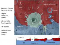
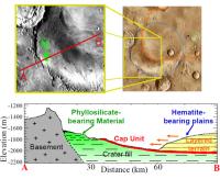
QUOTE (CosmicRocker @ May 2 2011, 01:23 AM) That geologic map has been used in a number of publications at various scales.... Interesting that you should present a map which includes both Endeavour Crater (upper right) and Miyamoto (lower left). I was looking at a paper that presented Miyamoto as a possible landing site for MSL because of the presence of phyllisilicates (before that site was dropped from the list). The papers on Miyamoto phyllisilicates and on Endeavour rim phyllosilicates have three authors in common (Arvidson, Wiseman, Murchie) but the papers come to different conclusions as to the source of the phyllosilicate signal. In the case of Miyamoto Crater, the signal is shown as coming from crater fill while in the case of Endeavour, the signal is hypothesized to come from exposed layers in Endeavour's rim.
Miyamoto http://www.lpi.usra.edu/meetings/lpsc2008/pdf/1806.pdf (Above, upper right, is a Google Mars image that I included to show the relationship of Miyamoto (blue), Endeavour (green), boundary of Meridiani sulfate layers (orange), and approximate location of Opportunity (blue dot).
Endeavour "...hypothesized stratigraphy, with subhorizontal hematitic plains layers (gray, short dashes) overlying layers with hydration signature (cyan, long dashes), which onlap tilted phyllosilicate-bearing layers (red lines) exposed in Endeavour rim." http://www.planetary.brown.edu/pdfs/3954.pdf (previously linked in post 275) |
||
|
|
|
||
|
May 2 2011, 10:33 AM
Post
#284
|
|
|
Solar System Cartographer Group: Members Posts: 10150 Joined: 5-April 05 From: Canada Member No.: 227 |
"That geologic map has been used in a number of publications at various scales. The green unit has not always been clearly defined in the publications. One paper that I found seems to suggest that the green (CT) simply maps post-Noachian craters. "
That's not the same map at a variety of scales - you can't deduce anything from one regarding the other. Phil -------------------- ... because the Solar System ain't gonna map itself.
Also to be found posting similar content on https://mastodon.social/@PhilStooke NOTE: everything created by me which I post on UMSF is considered to be in the public domain (NOT CC, public domain) |
|
|
|
|
May 2 2011, 05:14 PM
Post
#285
|
|
 Administrator Group: Admin Posts: 5172 Joined: 4-August 05 From: Pasadena, CA, USA, Earth Member No.: 454 |
QUOTE (CosmicRocker @ May 1 2011, 10:23 PM) That geologic map has been used in a number of publications at various scales. The green unit has not always been clearly defined in the publications. One paper that I found seems to suggest that the green (CT) simply maps post-Noachian craters. It's not a very useful designation, but perhaps the best available. CosmicRocker, as a Real Geologist you'll know what I mean when I say that CT on many geologic maps of Mars is sort of equivalent to Qf on Earth geologic maps. It's the crap that gets in the way of us seeing what's going on with the bedrock. Anything exposed in crater walls is usually too small in spatial extent to be mapped intelligently; CT covers the crater and its ejecta that obscure what was going on underneath, just like Quaternary fill obscures geology in Earth's valley floors. -------------------- My website - My Patreon - @elakdawalla on Twitter - Please support unmannedspaceflight.com by donating here.
|
|
|
|
|

|
Lo-Fi Version | Time is now: 23rd April 2024 - 09:03 PM |
|
RULES AND GUIDELINES Please read the Forum Rules and Guidelines before posting. IMAGE COPYRIGHT |
OPINIONS AND MODERATION Opinions expressed on UnmannedSpaceflight.com are those of the individual posters and do not necessarily reflect the opinions of UnmannedSpaceflight.com or The Planetary Society. The all-volunteer UnmannedSpaceflight.com moderation team is wholly independent of The Planetary Society. The Planetary Society has no influence over decisions made by the UnmannedSpaceflight.com moderators. |
SUPPORT THE FORUM Unmannedspaceflight.com is funded by the Planetary Society. Please consider supporting our work and many other projects by donating to the Society or becoming a member. |
|