Opportunity Route Map |

  |
Opportunity Route Map |
 Jun 1 2006, 01:36 PM Jun 1 2006, 01:36 PM
Post
#1456
|
|
 Senior Member  Group: Members Posts: 2488 Joined: 17-April 05 From: Glasgow, Scotland, UK Member No.: 239 |
QUOTE (Bill Harris @ Jun 1 2006, 10:49 AM)  Tom, it is clear that Oppy is headed into an old crater, the depression means a lower wind velocity and net deposition of sand and apparently softer sand. I'll suspect that Oppy will go a biy westward and step along the outcrop stepping stones instead of staying due south. --Bill Bill: I'd been wondering about that too - there must be lots of old craters covered in surface drift material, and from a distance such traps would look very much like any other part of the landscape. It seems perfectly reasonable to expect a fluffy and uncompacted texture. We may just have been very lucky so far! On a statistical note, we've had one bad dune and one halfway bad dune; and we've seen less than a dozen small craters overall. The numbers seem to tie in, don't they? Bob Shaw -------------------- Remember: Time Flies like the wind - but Fruit Flies like bananas!
|
 |
 
|
|
Jun 1 2006, 05:30 PM
Post
#1457
|
|
|
Member Group: Members Posts: 530 Joined: 21-March 06 From: Canada Member No.: 721 |
QUOTE (Bill Harris @ Jun 1 2006, 03:49 AM) I'll suspect that Oppy will go a biy westward and step along the outcrop stepping stones instead of staying due south. Where would you cross over? Just head west over the dunes maybe a little bit back north, or head all the way back to the exposed rock where they veered off The Thin Blue Line to avoid major ripple crossing? Brian |
|
|
|
|
Jun 2 2006, 12:37 AM
Post
#1458
|
|
 Senior Member Group: Moderator Posts: 2262 Joined: 9-February 04 From: Melbourne - Oz Member No.: 16 |
QUOTE (djellison @ Jun 1 2006, 07:31 PM) Now - when you're doing mid-drive imaging (like visidom for slip check or documenting egress progress from a dune) - you have to drive...stop...take images...and drive again..and repeat. Each time you do that - you increase the drive number... Just to clarify slightly - Doug's reply makes it sound like the drive number is incremented by one for each image taken. This is nearly always not true. See my plots in this post points are shown with the difference in drive number between consecutive images. Most site/drive numbers have no images (100's at a time sometimes) - I suspect that the drive number is incremented whenever an internal mesurement is taken (rover orientation, etc) not when a picture is taken at a new position. Note there are some cases where a small movement of the rover happens but there is no increment in drive number. James -------------------- |
|
|
|
|
Jun 2 2006, 01:48 AM
Post
#1459
|
|
|
Merciless Robot Group: Admin Posts: 8783 Joined: 8-December 05 From: Los Angeles Member No.: 602 |
QUOTE (Bob Shaw @ Jun 1 2006, 06:36 AM) Bill: I'd been wondering about that too - there must be lots of old craters covered in surface drift material, and from a distance such traps would look very much like any other part of the landscape. It seems perfectly reasonable to expect a fluffy and uncompacted texture. We may just have been very lucky so far! On a statistical note, we've had one bad dune and one halfway bad dune; and we've seen less than a dozen small craters overall. The numbers seem to tie in, don't they? Bob Shaw Interesting correlation if true...and an outstanding example of the value of "ground truth" vs. remote sensing!  The MERs just keep on giving & giving... The MERs just keep on giving & giving...
-------------------- A few will take this knowledge and use this power of a dream realized as a force for change, an impetus for further discovery to make less ancient dreams real.
|
|
|
|
|
Jun 2 2006, 06:45 AM
Post
#1460
|
|
|
Founder Group: Chairman Posts: 14432 Joined: 8-February 04 Member No.: 1 |
QUOTE (jamescanvin @ Jun 2 2006, 01:37 AM) Just to clarify slightly - Doug's reply makes it sound like the drive number is incremented by one for each image taken. This is nearly always not true. See my plots in this post points are shown with the difference in drive number between consecutive images. Most site/drive numbers have no images (100's at a time sometimes) - I suspect that the drive number is incremented whenever an internal mesurement is taken (rover orientation, etc) not when a picture is taken at a new position. Note there are some cases where a small movement of the rover happens but there is no increment in drive number. James Of course, one could also put visidom slip checks into the catagory og 'internal measurement' - and those images rarely get downlinked Doug |
|
|
|
|
Jun 2 2006, 07:47 AM
Post
#1461
|
|
|
Senior Member Group: Moderator Posts: 4279 Joined: 19-April 05 From: .br at .es Member No.: 253 |
QUOTE (jamescanvin @ Jun 2 2006, 02:37 AM) Note there are some cases where a small movement of the rover happens but there is no increment in drive number. Example? |
|
|
|
|
Jun 2 2006, 08:50 AM
Post
#1462
|
|
 Special Cookie Group: Members Posts: 2168 Joined: 6-April 05 From: Sintra | Portugal Member No.: 228 |
QUOTE (CosmicRocker @ Jun 1 2006, 06:34 AM) It appears to me that Opportunity has recently decended into an ancient crater whose circular outline is apparent on Tesheiner's maps. The decent can be seen in recent anaglyphs from Opportunity. It appears to me that the crater's basin is directly in our path, and I wonder if the aeolian sediment in this crater is more treacherous than elsewhere, and responsible for the recent wheel embedding hazard. Looks like it... Looking at your anaglyph it seems, to me, that there are some other ancient ones scattered all around: http://i16.photobucket.com/albums/b14/ustrax3/scr.jpg -------------------- "Ride, boldly ride," The shade replied, "If you seek for Eldorado!"
Edgar Alan Poe |
|
|
|
|
Jun 3 2006, 06:28 AM
Post
#1463
|
||
 Senior Member Group: Members Posts: 2228 Joined: 1-December 04 From: Marble Falls, Texas, USA Member No.: 116 |
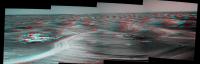
ustrax: There surely are many ancient, and sometimes overlapping craters in this region that are now partially mantled by the more recent windblown sediment. Bill took a stab at identifying some of them a while back. Identifying them is really is a bit subjective. The circles I would draw on a map would problably not always agree with those drawn by someone else, but we could all agree on some of them.
The rover-based imagery really helps out in this regard. Erebus really looked like an ancient crater from orbit, and when Opportunity arrived there, "the most casual observer" could see through her eyes that it truly was a crater. This one is slightly less obvious, but Opportunity shows it to us from her perspective. Here is an anaglyph view from Opportunity on sol 830. Making a good anaglyph of a stitched panorama can sometimes be quite challenging, and this one is less than optimal. It is just a quick and dirty Autostitch of pancam anaglyphs from MMB. I think it turned out better than my other attempts to create a more refined anaglyph. I do not know how it appears to others, but I can see a slight depression ahead, and the far rim as a local high that is obscuring the view beyond. If Opportunity can make it to the opposite side (and I have little doubt she will make it), we might finally get the "hell of a view" that we have been anticipating for so long. From the other side, I hope we will have a much nicer view of Corner Crater and the Victoria ejecta blanket escarpment that appears to be behind it, not to mention, of Victoria in all her splendor. Well, at least in some of her splendor...  P.S. By the way, did you read the abyss piece from Kazantzakis that I sent to you? What did you think of it?
Attached thumbnail(s)
-------------------- ...Tom
I'm not a Space Fan, I'm a Space Exploration Enthusiast. |
|
|
|
|
|
|
Jun 3 2006, 08:24 AM
Post
#1464
|
|
|
Senior Member Group: Moderator Posts: 2262 Joined: 9-February 04 From: Melbourne - Oz Member No.: 16 |
QUOTE (djellison @ Jun 2 2006, 04:45 PM) Of course, one could also put visidom slip checks into the catagory og 'internal measurement' - and those images rarely get downlinked Is that really true? I thought nearly all these images were downlinked in the end, hence why lots of driving can start to fill up the flash, as these images are not deleted soon after the drive. QUOTE (Tesheiner @ Jun 2 2006, 05:47 PM) Example? Well there are several examples in the tracking database where there appears to be movement e.g. CODE /oss/merb/ops/ops/surface/tactical/sol/792/opgs/edr/ncam/1N198495723ETH68TTF0006L0M1.IMG::68::813::18.2986::-132.529::-0.509746 /oss/merb/ops/ops/surface/tactical/sol/792/opgs/edr/ncam/1N198495560ETH68TTF0006L0M1.IMG::68::813::18.4561::-132.648::-0.552558 /oss/merb/ops/ops/surface/tactical/sol/792/opgs/edr/ncam/1N198495893ETH68TTF0006L0M1.IMG::68::813::18.3004::-132.529::-0.511131 But after looking at the images http://marsrovers.jpl.nasa.gov/gallery/all...TTF0006L0M1.JPG http://marsrovers.jpl.nasa.gov/gallery/all...TTF0006L0M1.JPG There doesn't appear to be any actual movement - another mystery... == btw: Good to see JPL have given up trying to keep up and are using your map now!  James -------------------- |
|
|
|
|
Jun 3 2006, 01:05 PM
Post
#1465
|
|
|
Senior Member Group: Moderator Posts: 4279 Joined: 19-April 05 From: .br at .es Member No.: 253 |
QUOTE (jamescanvin @ Jun 3 2006, 10:24 AM) Is that really true? I thought nearly all these images were downlinked in the end, hence why lots of driving can start to fill up the flash, as these images are not deleted soon after the drive. I think both of you are right. Those pics are rarely downlinked, yes, but just because of the priority queue. QUOTE btw: Good to see JPL have given up trying to keep up and are using your map now! James Mmm, when, where? Are you talking (maybe) about the pic in Planetary Society's MER Rovers Update? |
|
|
|
|
Jun 3 2006, 11:11 PM
Post
#1466
|
|
|
Senior Member Group: Moderator Posts: 2262 Joined: 9-February 04 From: Melbourne - Oz Member No.: 16 |
QUOTE (Tesheiner @ Jun 3 2006, 11:05 PM) Mmm, when, where? Are you talking (maybe) about the pic in Planetary Society's MER Rovers Update? Oops, yes, I wasn't quite with it yesterday.
-------------------- |
|
|
|
|
Jun 5 2006, 02:45 PM
Post
#1467
|
|
|
Senior Member Group: Moderator Posts: 4279 Joined: 19-April 05 From: .br at .es Member No.: 253 |
QUOTE (jamescanvin @ Jun 2 2006, 02:37 AM) I suspect that the drive number is incremented whenever an internal mesurement is taken (rover orientation, etc) not when a picture is taken at a new position. See my comments on this other thread. I thought it was too technical (but still interesting) to continue it here. |
|
|
|
|
Jun 6 2006, 01:45 PM
Post
#1468
|
|
|
Special Cookie Group: Members Posts: 2168 Joined: 6-April 05 From: Sintra | Portugal Member No.: 228 |
QUOTE (CosmicRocker @ Jun 3 2006, 07:28 AM) The rover-based imagery really helps out in this regard. Erebus really looked like an ancient crater from orbit, and when Opportunity arrived there, "the most casual observer" could see through her eyes that it truly was a crater. This one is slightly less obvious, but Opportunity shows it to us from her perspective. Here is an anaglyph view from Opportunity on sol 830. Making a good anaglyph of a stitched panorama can sometimes be quite challenging, and this one is less than optimal. It is just a quick and dirty Autostitch of pancam anaglyphs from MMB. I think it turned out better than my other attempts to create a more refined anaglyph. I do not know how it appears to others, but I can see a slight depression ahead, and the far rim as a local high that is obscuring the view beyond. If Opportunity can make it to the opposite side (and I have little doubt she will make it), we might finally get the "hell of a view" that we have been anticipating for so long. From the other side, I hope we will have a much nicer view of Corner Crater and the Victoria ejecta blanket escarpment that appears to be behind it, not to mention, of Victoria in all her splendor. Well, at least in some of her splendor... P.S. By the way, did you read the abyss piece from Kazantzakis that I sent to you? What did you think of it? Yes...I agree, even if that can mean non pleasant surprises for Opportunity in situ... The anaglyph gave that impression too...Hope not but the rover is moving through a 'mine field' with sand as camouflage... Splendor?...Fasten your seat belts! Near rim is our destiny!  And yes, I've read on those glorious Ultreya / El Dorado days the Kazantzakis you've sent me... I can tell you some of the ideas had become a sort of beacon...It's there...So find the better route. I'll send you an e-mail with my impressions about it. And thank you once more. Edited: "Where is the abyss? That is where I am headed. What is the most valiant joy? To assume complete responsibility!" -------------------- "Ride, boldly ride," The shade replied, "If you seek for Eldorado!"
Edgar Alan Poe |
|
|
|
|
Jun 6 2006, 04:56 PM
Post
#1469
|
||
|
Senior Member Group: Moderator Posts: 4279 Joined: 19-April 05 From: .br at .es Member No.: 253 |
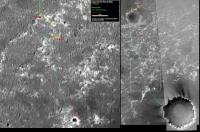
Sol 841 drive wasn't really big in terms of distance, but given its significance I think it deserves an updated route map.
|
|
|
|
|
|
|
Jun 6 2006, 06:21 PM
Post
#1470
|
|
 Senior Member Group: Members Posts: 1229 Joined: 24-December 05 From: The blue one in between the yellow and red ones. Member No.: 618 |
QUOTE (Tesheiner @ Jun 6 2006, 06:56 AM) Sol 841 drive wasn't really big in terms of distance, but given its significance I think it deserves an updated route map. Yessiree Bob! Go west, young MER!
-------------------- My Grandpa goes to Mars every day and all I get are these lousy T-shirts!
|
|
|
|
|

|
Lo-Fi Version | Time is now: 27th April 2024 - 07:10 AM |
|
RULES AND GUIDELINES Please read the Forum Rules and Guidelines before posting. IMAGE COPYRIGHT |
OPINIONS AND MODERATION Opinions expressed on UnmannedSpaceflight.com are those of the individual posters and do not necessarily reflect the opinions of UnmannedSpaceflight.com or The Planetary Society. The all-volunteer UnmannedSpaceflight.com moderation team is wholly independent of The Planetary Society. The Planetary Society has no influence over decisions made by the UnmannedSpaceflight.com moderators. |
SUPPORT THE FORUM Unmannedspaceflight.com is funded by the Planetary Society. Please consider supporting our work and many other projects by donating to the Society or becoming a member. |
|