Printable Version of Topic
Click here to view this topic in its original format
Unmanned Spaceflight.com _ Chit Chat _ Locating landers by panoramic horizon imaging
Posted by: lollipop Sep 9 2019, 09:35 AM
Has anyone (for example the great Phil Stooke) ever described a procedure for establishing the location of a lander on a map or orbiter image by reference to peaks seen in horizon images taken by the lander?
This has proved to be a tricky one to search for on the forum although I know individual examples have been discussed both for MER and lunar landers. I thought of this while browsing an entirely different forum https://www.railforums.co.uk/threads/longest-line-of-sight-uk.136247/ where sightlines were being discussed, and posters were challenging the identity of horizon features seen from a known location, a sort of reverse problem to that faced on here.
Posted by: Phil Stooke Sep 10 2019, 02:33 AM
I don't know about a procedure description, but let me throw in a bit of history for anyone interested.
----------------------
Surveyor 1 images of the northern horizon revealed the hills Flamsteed Theta and Flamsteed Phi in the distance. These made a search for its location feasible, and so the Surveyor 1 landing site became the first to be identified on another world. Tracking suggested a landing at 2.49º S, 43.32º W (Figure 44). The Surveyor Scientific Evaluation and Analysis Team (Jaffe et al. 1966) tried to match observed hills on the horizon with features drawn on the ACIC chart of the area and found two possible matches. One coincided with the tracking position but did not fully account for the observed hills. The other, at 2.15º S, 43.35º W, gave a better match to the hills but was 10 km north of the tracking point and 5 km outside the uncertainty ellipse around that point.
Ewen Whitaker (University of Arizona) attempted to clarify this uncertainty by using the best original telescopic images of the area rather than the chart used by Jaffe et al. (1966). The images allowed a better match to the horizon features, giving a new location of 2.57º S, 43.34º W, very close to the tracking point (Whitaker 1966). Later the spacecraft was unambiguously located in Lunar Orbiter 3 image LO3-183-H1 (Spradley et al., 1967). Surveyor 1 appeared as a bright spot casting a 10 m-long shadow. With hindsight the spot was also visible in Lunar Orbiter 1 medium resolution images (e.g. LO1-192-M), but it could not be conclusively identified until the later image showed it more clearly. The length of the shadow was one of the deciding factors in its identification.
Jaffe, L. D., Dwornik, S. E., Alexander, W. M., Batterson, S. A., Scott, R. F., Shoemaker, E. M., Sutton, G. H. and Turkevich, A., 1966. Surveyor 1: preliminary results. Science, v. 152, pp. 1737-1750.
Spradley, L. H., Steinbacher, R., Grolier, M. and Byrne, C., 1967. Surveyor 1: location and identification. Science, v. 157, pp. 681-684.
Whitaker, E. A., 1966. Surveyor 1 location. Science, v. 153, pp. 1550-1551.
----------------------
Phil
Posted by: John Moore Sep 10 2019, 08:48 AM
Phil...simply a wonderful reply of knowledge to the inquirer, and others like here, I would imagine !!!
John
Posted by: Phil Stooke Sep 10 2019, 08:34 PM
Thanks, John.
This method is really the same as the standard method for finding your location on Earth by the process of Intersection (A similar method is called Resection). See this example:
https://www.armystudyguide.com/content/army_board_study_guide_topics/land_navigation_map_reading/find-a-location-using-int.shtml
The more points you can identify the better.
Also, here is an illustration of the method for Chang'e 3.
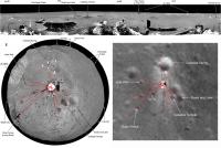
|
Phil
Posted by: HSchirmer Sep 10 2019, 11:22 PM

The more points you can identify the better.
Eh, "The Englishman who went up a hill and came down a mountain"...
http://www.surveyhistory.org/englishman_who_went_up_a_hill.htm
Powered by Invision Power Board (http://www.invisionboard.com)
© Invision Power Services (http://www.invisionpower.com)