

Mercury mosaics from January 2008 Flyby |

  |
Mercury mosaics from January 2008 Flyby |
 Jul 20 2008, 08:40 PM Jul 20 2008, 08:40 PM
Post
#31
|
|
 Interplanetary Dumpster Diver  Group: Admin Posts: 4404 Joined: 17-February 04 From: Powell, TN Member No.: 33 |
I LOVE this version! Not to mention the fact that for Mercury, the dynamic range issues that crop up with gamma correction are huge, given the intense solar illumination.
-------------------- |
 |
 
|
|
Jul 20 2008, 08:58 PM
Post
#32
|
|
 Senior Member Group: Members Posts: 3648 Joined: 1-October 05 From: Croatia Member No.: 523 |
Thanks, all. It'd be even better if it was properly geometrically reprojected. Oh well...
Ted, gamma correction has nothing to do with the amount of illumination - you simply darken the image/change the exposure. It has to do with the amount of contrast and how the physical brightness is mapped to the nonlinear video device. A corect gamma actually ensures proper DN - brightness mapping, it's not black magic of some kind. The problem is the sRGB colorspace nowadays assumes 2.2 gamma function, which digital cameras, video cameras etc. will automatically output. Spacecraft data, when calibrated, is linear so a difference arises if you simply shove the calibrated intensities into RGB values. I'm sure you're perfectly aware of this, but for others - take a look at the following image (click): 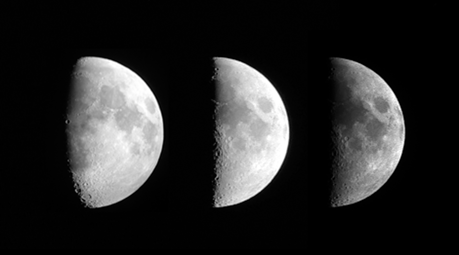 The image on the left is a digital camera image of the Moon, which approximates what human eye sees. The image on the right is a calibrated Cassini WAC image, no gamma correction - the same as Mercury here. The middle image is the Cassini image with 2.2 gamma. Note gamma doesn't overexpose the data, I brightened the middle image to match the left one better. Both the left and middle images nicely show the Moon as it appears, while the image on the right does not. The advantage you're probably thinking here of no gamma correction is that Mercury has lower albedo variations than the Moon does, so it would wash out details. Then again, that's how the planet actually looks like. Something like this, for better or worse. -------------------- |
|
|
|
|
Jul 20 2008, 09:09 PM
Post
#33
|
|
|
Interplanetary Dumpster Diver Group: Admin Posts: 4404 Joined: 17-February 04 From: Powell, TN Member No.: 33 |
I understand the concept. The problem is that the range from the darkest black to the brightest white is huge, especially when compared to places such as the Saturnian system. A computer monitor can't come anywhere close to portraying such a range. In fact, it is only at the Uranian system that one could truly show the full range on a monitor. The problem is that even on the best monitor, the darkest dark is nowhere near true black, and the brightest white is relatively dark compared to daylight outdoors. As a result, A lot of the detail that the eye could discern were it viewing the real planet is lost. I find the whole issue to be a lot like trying to make a flat map of a round world. No method is truly "accurate" - each have their advantages and disadvantages.
The problem in that example is that in both gamma-corrected images, the whites are murdered, especially in the Cassini one. Looking through a telescope, that wouldn't happen. -------------------- |
|
|
|
|
Jul 21 2008, 08:08 PM
Post
#34
|
|
|
Senior Member Group: Members Posts: 1582 Joined: 14-October 05 From: Vermont Member No.: 530 |
Interesting. I had been thinking that high dynamic range composites were mostly to make up for low dynamic range cameras, but a little more googling around makes it clear that it's also a compromise to the low dynamic range of computer monitors. Sounds like and HDR algorithm could take the corrected and uncorrected images and composite them into something approximating what you say you could see through a telescope. (Or is it better to try "tone mapping" the original data into an image suitable for display on a monitor?) I don't necessarily follow all of the details and terms, but the discussion here does remind me of the reasons HDR got popular (fadish?).
|
|
|
|
|
Jul 21 2008, 08:43 PM
Post
#35
|
|
|
Senior Member Group: Members Posts: 3648 Joined: 1-October 05 From: Croatia Member No.: 523 |
The point of a gamma function is not to convey the entire dynamic range of what is probably a huge starting dynamic range in the first place. Your analogy with the Uranian system makes it seem that gamma correction doesn't have any place here on Earth, as you say a monitor can't cope with the huge dynamic range of our world down here. Yet it doesn't prevent anyone from watching TV here or using digital cameras on Earth and having reasonably good colors and contrast, albeit not as bright as the real thing.
Even if gamma destroys whites (and it's not exactly true, it's those white levels being close in brightness in the first place, also the Cassini image was overexposed by me accidentally), I can come up with a counterargumet that no gamma correction destroys darks - check out the terminator region in the rightmost image, it's gone. Either way - you lose detail somewhere, the question is which one is preferred. Shoving linear data onto a computer screen has many advantages and don't get me wrong, I actually use very little to no gamma manipulation in my composites of most Saturnian system moons because they're bland as hell, but every once and again I like seeing the amount of contrast and color saturation an object would actually have in real life. Yes, the eye can make out a surprising amount of detail even in such cases especially on closer scrutiny, but having an accurate display on a screen is one step closer to what reality looks (at first glance at least, before your eye adapts to lower contrast of the real thing) than an inaccurate display. Of all the solar system bodies, Mercury, Earth, the Moon and Mars are the places where I'd want to see gamma corrected imagery in addition to the usual processings just so I can visualize what they'd look like through a scope or simply naked eye. In case of Mercury, up until now all I saw were Mariner composites with very saturated brown colors yet observers said it just has a touch of a soft coppery hue. -------------------- |
|
|
|
|
Jul 21 2008, 11:02 PM
Post
#36
|
|
|
Interplanetary Dumpster Diver Group: Admin Posts: 4404 Joined: 17-February 04 From: Powell, TN Member No.: 33 |
The problem effects images of things on earth as well. That is why it is hard to show shadows without wiping out bright areas or vice versa. The best way around it is a nonlinear curve that is selectively set up to show details in both areas.
My point with this whole issue is to say that gamma correction isn't necissarily the same thing as showing what the eye would see, if that is one's goal (personally, I love looking at images with color shifting from infrared, which tends to bring out a lot of interesting things). -------------------- |
|
|
|
|
Jul 23 2008, 12:13 PM
Post
#37
|
|
 Administrator Group: Admin Posts: 5172 Joined: 4-August 05 From: Pasadena, CA, USA, Earth Member No.: 454 |
-------------------- My website - My Patreon - @elakdawalla on Twitter - Please support unmannedspaceflight.com by donating here.
|
|
|
|
|
Jul 24 2008, 07:28 PM
Post
#38
|
|
 IMG to PNG GOD Group: Moderator Posts: 2250 Joined: 19-February 04 From: Near fire and ice Member No.: 38 |
QUOTE (djellison @ Jul 17 2008, 08:23 AM)  Some words on img2png and the MDIS imagery would be good- - which tags we should be using for calibrated results. I just finished a new version of IMG2PNG that can properly read the calibrated Messenger image files. However, it can't calibrate the raw images (the mdis volume) even though it reads them - I didn't see any need for this since calibrated images are available (the msgrmds_2001 volume). The new version is available here. Further information on IMG2PNG is available here. QUOTE (volcanopele @ Jul 17 2008, 02:29 AM) The only problem is, I don't trust built-in geometry one iota. I guess if the images are high res enough, it doesn't matter, but with global to regional scale mosaics, it can be a problem. I assume you are referring to the viewing geometry information that's usually present in the IMG, LBL or index files. Yes, this is an extremely annoying problem. I'm making DEMs of all of Saturn's icy satellites and about 90% of the time the pointing information isn't accurate enough so I need to 'reverse engineer' it. In contrast, the spacecraft's location seems accurate. It's also frustrating that for any spacecraft, as far as I know updated pointing information usually isn't made available if/when it is determined. Remarkably, the pointing information for the Galileo images was usually pretty accurate though. So my software for reprojecting images wouldn't be useful unless potential users were willing to reverse engineer the viewing geometry themselves when the results look bad (this might turn into something useful - exchanging updated pointing info...). |
|
|
|
|
Jul 24 2008, 07:31 PM
Post
#39
|
|
 Senior Member Group: Moderator Posts: 3232 Joined: 11-February 04 From: Tucson, AZ Member No.: 23 |
If, and that's a BIG if, I decide to try to mosaic these MESSENGER images using ISIS, I would have no problem sharing the pointing info I derive.
-------------------- &@^^!% Jim! I'm a geologist, not a physicist!
The Gish Bar Times - A Blog all about Jupiter's Moon Io |
|
|
|
|
Jul 24 2008, 07:49 PM
Post
#40
|
|
|
Senior Member Group: Members Posts: 3648 Joined: 1-October 05 From: Croatia Member No.: 523 |
If by deriving pointing info you mean limb-fitting and stuff like that, the idea I thought would be nice to implement would be to do this visually. An application would take a list of images and their corresponding spacecraft location (assuming that bit is pretty much precise) relative to the planet, project the initial geometry onto the planet spheroid and would then let you tweak the mosaic footprints by shifting and/or rotating. And allow you to do that in a graphical user interface. This would obviously be feasible for small mosaics, not likely to be useful for 80-odd footprints.
Yeah, I'll be able to implement something like that when hell freezes over... -------------------- |
|
|
|
|
Jul 24 2008, 11:48 PM
Post
#41
|
|
 Senior Member Group: Members Posts: 1628 Joined: 5-March 05 From: Boulder, CO Member No.: 184 |
Does anyone happen to know the distance of Messenger from Mercury when these hi-res mosaics were made? What I'm getting at would be the "equivalent" distance of the projection used in making the mosaics, if this is something like the average distance of the range stated in VP's post. This would be nice to check on as I'm testing this mosaic now in my map.
Also, are we seeing all the way to the limb in this projection? Thanks Steve |
|
|
|
|
Jul 25 2008, 10:48 AM
Post
#42
|
|
|
Senior Member Group: Members Posts: 3648 Joined: 1-October 05 From: Croatia Member No.: 523 |
Which mosaic are you talking about, Steve? I know the global color mosaic I did uses the NAC mosaic #4, the last outbound mosaic. It was overlaid onto the last WAC global color shot and so it effectively mimics that viewpoint apart from the extreme limb to the right. There's some severely distorted terrain there which was not visible in the earlier wide-angle so it couldn't fit the global image. As a result I'd say on average something up to 100-200 pixels on the right limb can't be trusted. The south and north poles should be about right, but with a bit of distortion as well. The center portion of the disc ought to fit reasonably well.
-------------------- |
|
|
|
|
Jul 25 2008, 07:35 PM
Post
#43
|
|
|
Senior Member Group: Members Posts: 1628 Joined: 5-March 05 From: Boulder, CO Member No.: 184 |
Hi Gordan. Yes I'm referring both to the one you did in post #28 and VP's in post #2. I can see this is a bit interesting and tricky if the hi-res black and white mosaic is taken from a farther distance and can see a larger portion of terrain near the limb compared with the WAC global color shot.
As an initial experiment I ran your #28 image in the map assuming it was at the same distance as the WAC shot. This appears to be close, though maybe slightly off in that I should maybe adjust the assumed distance (closer to the distance of the NAC frames) to account for some additional terrain showing up near the limb. I also tweaked things so I used the color information over most of your image except just black & white near the terminator where the hue in the shadows may drift a bit. Overall the results even at this stage may be good enough for me to soon post. Perhaps it might be better if I use VP's mosaic for the B&W info near the limb (if it has more coverage near the limb) and then overlay yours to show the region interior to that that has color? Steve |
|
|
|
|
Jul 25 2008, 07:51 PM
Post
#44
|
|
|
Senior Member Group: Members Posts: 3648 Joined: 1-October 05 From: Croatia Member No.: 523 |
QUOTE (scalbers @ Jul 25 2008, 09:35 PM) Perhaps it might be better if I use VP's mosaic for the B&W info near the limb (if it has more coverage near the limb) and then overlay yours to show the region interior to that that has color? VP can chime on this, when I compared his huge mosaic to the WAC frame it showed some distortion (a kind of narrowing and "shearing" the disc) towards the bottom that might have come up if if was automatically stitched with frames taken during a prolonged period of time. MESSENGER was really hauling the mail after C/A and even a couple of minutes was enough to considerably change the viewing geometry. This was precisely the reason I used an actual WAC frame as base for NAC footprints as compromise to minimize distortions. His mosaic is of sufficiently high resolution that maybe fitting the pieces section by section into your map might work better than attempting to fit the whole mosaic at once? -------------------- |
|
|
|
|
Jul 26 2008, 12:06 AM
Post
#45
|
|
|
Senior Member Group: Members Posts: 1628 Joined: 5-March 05 From: Boulder, CO Member No.: 184 |
I'll have to consider this a bit. Off-hand I'm basically looking for some short cuts to try and get some high-res color imagery into the map without too much distortion. Even the current attempt appears to have done that. It would take me a while to get all the 87 individual images from VPs mosaic (post #2) into the map. This would be somewhat easier though if I had the precise pointing info discussed a few posts back. The MESSENGER visualization tool has some partial info I see.
I can easily try VPs mosaic #2 in the map to see how the limb reprojects itself compared with your mosaic to get a further feel for what you have described. I could also break up VP's mosaic into larger sections if that is what you were getting at. On the other hand the NAC #4 mosaic that you used would show more terrain near the limb as it is taken from a farther distance. Given that it has "just" 25 or so images it would be easier to consider the individual frames as well. Steve |
|
|
|
|

|
Lo-Fi Version | Time is now: 24th April 2024 - 06:22 PM |
|
RULES AND GUIDELINES Please read the Forum Rules and Guidelines before posting. IMAGE COPYRIGHT |
OPINIONS AND MODERATION Opinions expressed on UnmannedSpaceflight.com are those of the individual posters and do not necessarily reflect the opinions of UnmannedSpaceflight.com or The Planetary Society. The all-volunteer UnmannedSpaceflight.com moderation team is wholly independent of The Planetary Society. The Planetary Society has no influence over decisions made by the UnmannedSpaceflight.com moderators. |
SUPPORT THE FORUM Unmannedspaceflight.com is funded by the Planetary Society. Please consider supporting our work and many other projects by donating to the Society or becoming a member. |
|


