ispace (Hakuto-R) Mission 1, Japanese private lunar mission |

  |
ispace (Hakuto-R) Mission 1, Japanese private lunar mission |
 Apr 25 2023, 05:51 PM Apr 25 2023, 05:51 PM
Post
#46
|
|
|
Member  Group: Members Posts: 401 Joined: 5-January 07 From: Manchester England Member No.: 1563 |
QUOTE Thanks to iSpace for the great presentation ! Seconded - well done to the team! I'm still expecting that it will be down in one piece, just a bit too hard to work as planned. -------------------- |
 |
 
|
|
Apr 25 2023, 05:59 PM
Post
#47
|
|
|
Member Group: Members Posts: 149 Joined: 18-June 08 Member No.: 4216 |
QUOTE (marsbug @ Apr 25 2023, 06:15 PM)  On the spacenews feed it mentions that, tentatively, at 90 meters the lander was dropping at 33 km/ hour. The previous numbers were 54km/hour at 180 meters altitude. OK... this is little better than reading entrail I realise, but if, for the sake of argument, we take these as more-or-less accurate the lander would have reached 0 meters with a velocity of just under 2 meters/sec. This makes no account of whether the numbers are just vertical drop rate or overall velocity, or angle of descent. I just wanted to illustrate that they ispace team may not have been too far off the mark with their landing. The way I understand these landings, guidance brings you a few meters above the surface with zero horizontal & vertical velocity and with the landing legs pointed down. Then you free-fall to the surface. If any of these three conditions are not met, you most likely crash. Or there was a thruster malfunction in the last few moments when there is precious little margin for guidance to recover the situation. Actually, I am slightly surprised by how fast the team appears to have thrown down the towel. It could be that they saw trouble in the last telemetry packets and the loss of signal just came to confirm what they expected. Hopefully we will find out soon. |
|
|
|
|
Apr 25 2023, 06:56 PM
Post
#48
|
|
|
Solar System Cartographer Group: Members Posts: 10162 Joined: 5-April 05 From: Canada Member No.: 227 |
Sad news. So in the 21st Century it is China 3/3, rest of the world 0/3. Let's hope for more success later in the year.
Phil -------------------- ... because the Solar System ain't gonna map itself.
Also to be found posting similar content on https://mastodon.social/@PhilStooke Maps for download (free PD: https://upload.wikimedia.org/wikipedia/comm...Cartography.pdf NOTE: everything created by me which I post on UMSF is considered to be in the public domain (NOT CC, public domain) |
|
|
|
|
Apr 25 2023, 08:15 PM
Post
#49
|
|||
|
Solar System Cartographer Group: Members Posts: 10162 Joined: 5-April 05 From: Canada Member No.: 227 |
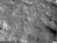
The livestream included an animated simulation of the landing over a contour map of the landing site. Assuming it accurately represented the planned landing, it gives a target point at the black dot here:
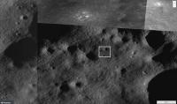
Using low sun angle LROC NAC images, it looks like this:
Quite a rough surface (though of course the long shadows exaggerate the roughness). I'm seeing hints from radio enthusiasts that there might have been a landing plus a bounce as if thrusters didn't cut off properly (as with Surveyor 3) or some other fault at the point of landing. https://twitter.com/uhf_satcom/status/1650921508728975361 Phil -------------------- ... because the Solar System ain't gonna map itself.
Also to be found posting similar content on https://mastodon.social/@PhilStooke Maps for download (free PD: https://upload.wikimedia.org/wikipedia/comm...Cartography.pdf NOTE: everything created by me which I post on UMSF is considered to be in the public domain (NOT CC, public domain) |
||
|
|
|
||
|
Apr 26 2023, 10:02 AM
Post
#50
|
|
 Member Group: Members Posts: 550 Joined: 1-May 06 From: Scotland (Ecosse, Escocia) Member No.: 759 |
Sad news to see this third failure of 3 different landing technologies (including Israel and India).
Only goes to enhance one's appreciation of the Chinese landing system, which worked 3 times in a row. |
|
|
|
|
Apr 26 2023, 01:44 PM
Post
#51
|
|
|
Senior Member Group: Members Posts: 2085 Joined: 13-February 10 From: Ontario Member No.: 5221 |
At least ispace was a softer sort of hard landing, and they will be making another attempt next year with what they learned from this one.
Even though they all happened at the same stage of of the landing process, the recent failures have all been different vehicles, so there's no data sharing of any kind on investigations to iterate changes from. |
|
|
|
|
Apr 26 2023, 02:45 PM
Post
#52
|
|
|
Member Group: Members Posts: 401 Joined: 5-January 07 From: Manchester England Member No.: 1563 |
I am slightly reminded of Philae landing on comet 67P - just slightly. Which is annoying because I don't think it's reasonable, at this point, to hope for any more contact from the lander. However I am still holding out hope that we'll eventually get evidence of the lander being intact, and perhaps (as per Phil Stooke's post above) that it did manage top soft land, but something went wrong afterwards - if that proved to be the case, would this still count as a successful soft landing I wonder? Though that is kinda a semantic discussion, so maybe not appropriate here.
-------------------- |
|
|
|
|
Apr 26 2023, 03:03 PM
Post
#53
|
|
|
Member Group: Members Posts: 540 Joined: 17-November 05 From: Oklahoma Member No.: 557 |
According to this detailed article on Spaceflight Now, the lander ran out of fuel while still at altitude, and came down hard from at least 90 meters up.
|
|
|
|
|
Apr 26 2023, 06:29 PM
Post
#54
|
|
|
Solar System Cartographer Group: Members Posts: 10162 Joined: 5-April 05 From: Canada Member No.: 227 |
Looks like this is becoming the accepted conclusion now. The earlier report I saw about landing and taking off must be a misinterpretation.
Now... does this allow us to calculate a crash site? I haven't seen anything about that yet. Phil -------------------- ... because the Solar System ain't gonna map itself.
Also to be found posting similar content on https://mastodon.social/@PhilStooke Maps for download (free PD: https://upload.wikimedia.org/wikipedia/comm...Cartography.pdf NOTE: everything created by me which I post on UMSF is considered to be in the public domain (NOT CC, public domain) |
|
|
|
|
Apr 26 2023, 06:45 PM
Post
#55
|
|
|
Member Group: Members Posts: 401 Joined: 5-January 07 From: Manchester England Member No.: 1563 |
About 17 meter/sec impact velocity, discounting any residual from the descent. Ouch. Edit: The reported (tentatively) rate of drop at 90 meters was 33 km/hour, or about 9 meters a second. So we could be looking at over 26 meters a second on impact - still, well done to the team for getting to 90 meters of the lunar surface and for the hard landing (it's still a landing on the moon!) and all the data returned up to that point. Roll on mission 2!
-------------------- |
|
|
|
|
May 10 2023, 09:08 PM
Post
#56
|
|
|
Senior Member Group: Members Posts: 2998 Joined: 30-October 04 Member No.: 105 |
...waiting for LROC imagery.
-------------------- |
|
|
|
|
May 10 2023, 10:24 PM
Post
#57
|
|
|
Solar System Cartographer Group: Members Posts: 10162 Joined: 5-April 05 From: Canada Member No.: 227 |
Yes indeed. There was an image opportunity only a few hours after landing. Presumably the image was taken, but it did not show the impact. Since we don't really know what went wrong in detail, it's not easy for those of us outside the mission to predict where the crash site should be. Did it overshoot the target? Was it off to one side? Perhaps the mission team have given the LROC people an updated target and we will get an image soon. If not a search might take a while.
Phil -------------------- ... because the Solar System ain't gonna map itself.
Also to be found posting similar content on https://mastodon.social/@PhilStooke Maps for download (free PD: https://upload.wikimedia.org/wikipedia/comm...Cartography.pdf NOTE: everything created by me which I post on UMSF is considered to be in the public domain (NOT CC, public domain) |
|
|
|
|
May 20 2023, 03:21 PM
Post
#58
|
|
|
Solar System Cartographer Group: Members Posts: 10162 Joined: 5-April 05 From: Canada Member No.: 227 |
Fascinating report here:
https://amsat-dl.org/en/analysis-of-hakuto-...on-2023-apr-25/ The conclusion is that the lander crashed about 99 km north of Atlas crater (depending on the angle of the final descent. This value assumes a vertical fall). There will be a statement from ispace on 26 May. Phil -------------------- ... because the Solar System ain't gonna map itself.
Also to be found posting similar content on https://mastodon.social/@PhilStooke Maps for download (free PD: https://upload.wikimedia.org/wikipedia/comm...Cartography.pdf NOTE: everything created by me which I post on UMSF is considered to be in the public domain (NOT CC, public domain) |
|
|
|
|
May 23 2023, 02:42 PM
Post
#59
|
|
|
Member Group: Members Posts: 103 Joined: 12-September 19 Member No.: 8664 |
Impact Site of the HAKUTO-R Mission 1 Lunar Lander.
http://lroc.sese.asu.edu/posts/1302 QUOTE From the temporal image pair, the LROC team identified an unusual surface change near the nominal landing site. The image shows at least four prominent pieces of debris and several small changes (47.581°N, 44.094°E).
|
|
|
|
|
May 23 2023, 03:30 PM
Post
#60
|
|
|
Solar System Cartographer Group: Members Posts: 10162 Joined: 5-April 05 From: Canada Member No.: 227 |
Not north of the crater as the previous analysis suggested.
Phil -------------------- ... because the Solar System ain't gonna map itself.
Also to be found posting similar content on https://mastodon.social/@PhilStooke Maps for download (free PD: https://upload.wikimedia.org/wikipedia/comm...Cartography.pdf NOTE: everything created by me which I post on UMSF is considered to be in the public domain (NOT CC, public domain) |
|
|
|
|

|
Lo-Fi Version | Time is now: 16th May 2024 - 04:29 PM |
|
RULES AND GUIDELINES Please read the Forum Rules and Guidelines before posting. IMAGE COPYRIGHT |
OPINIONS AND MODERATION Opinions expressed on UnmannedSpaceflight.com are those of the individual posters and do not necessarily reflect the opinions of UnmannedSpaceflight.com or The Planetary Society. The all-volunteer UnmannedSpaceflight.com moderation team is wholly independent of The Planetary Society. The Planetary Society has no influence over decisions made by the UnmannedSpaceflight.com moderators. |
SUPPORT THE FORUM Unmannedspaceflight.com is funded by the Planetary Society. Please consider supporting our work and many other projects by donating to the Society or becoming a member. |
|