Printable Version of Topic
Click here to view this topic in its original format
Unmanned Spaceflight.com _ Opportunity _ Endeavour Crater
Posted by: ustrax Sep 29 2008, 03:13 PM
Opportunity is getting ready to embark on her most extraordinary journey, a true rover epic.
As information regarding how to win the distance are being collected http://www.unmannedspaceflight.com/index.php?showtopic=5476, and the emotional last views from Victoria Crater are being discussed http://www.unmannedspaceflight.com/index.php?showtopic=5497, I thought about creating a new thread that will surely become an obligatory stop as the tall peaks and other features of Endeavour start to rise in the horizon.
Here we will be able to discuss the location of features seen from the distance, references that will help us understanding better what we are seing and that will, fortunately, feed our spirit across the long sail across the Meridiani sandwaves.
Ultreya! 
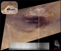
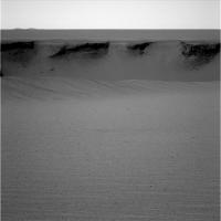
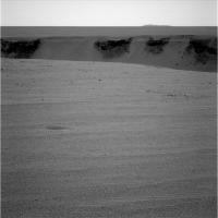
I give it a kick with http://qt.exploratorium.edu/mars/opportunity/navcam/2008-09-26/1N275637037EFF90VYP1663R0M1.JPG, comparing it with http://www.unmannedspaceflight.com/index.php?s=&showtopic=5476&view=findpost&p=126304:
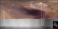
|
I'm sure James Canvin will correct me...

EDITED: I can't resist...I tried! I honestly tried, but it is stronger than me...so many features ahead and not a single name?!

Seriously, at Victoria we had features named after places visited by the vessel, and now for Endeavour? Assuming that Oppy will succeed on her quest will the mission keep the same policy, of naming places after Endeavour's tour? If so, there may be some names in common with Victoria...

While we are ready to leave the port once more I remembered that we could start naming, internally, (in order to have catchier landmark references...
) these features, as they loom in the horizon, after the ship's crew.We could follow the order presented http://www2.sl.nsw.gov.au/banks/series_03/crew_01.cfm.
Let me just edit the image up there...
Posted by: jamescanvin Sep 29 2008, 04:05 PM
 ´
´ It's been a long time - I may have to recheck it sometime, but http://www.unmannedspaceflight.com/index.php?showtopic=3215&st=0&p=68968&#entry68968 I reckoned that "Cook" was the hill further to the right of where you place it. (EDIT: now as I had it in the updated version)
Great names, great thread. This is going to be fun.

James
Posted by: ilbasso Sep 29 2008, 04:24 PM
Looking back at this thread from two years ago, I see this wonderful quote about the Big Crater from Our Fearless Leader:
Doug
Posted by: climber Sep 29 2008, 04:30 PM
James
I second this!
Rui, I was badly waiting for this trait coming from YOU and here it is!
It reminds so many memories,
it opens so many possibilities.
This is definitively going to be fun
Posted by: charborob Sep 29 2008, 04:34 PM
We should be on the lookout also for the ridge on the West side of Endeavour. It is about half the distance of Victoria to "Cook", and seems to be quite high.
Posted by: ustrax Sep 29 2008, 04:44 PM
Oh yes it will...and (why wasn't I surprised?...) you have come to the rescue once more!
I've corrected the image in the first post, don't want to start with the left foot...
charborob, there was a feature to the right of Cook appearing in previous images and I believe James pointed its location...I'll check it.
climber...we meet again!

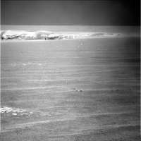
Posted by: fredk Sep 29 2008, 05:17 PM
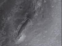
Thanks for pointing out we can see Endeavour in that image, ustrax! Gosh, what an image that is. First Sputnik crater in the foreground, only 7 metres or so across. Then the gaping aperture of our old friend Victoria, at 700 or so metres across. Finally, far away in the distance, the peaks of the rim of great Endeavour, our next destination, some 22 km across! Here's an anaglyph of that view:
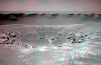
|
Posted by: jamescanvin Sep 29 2008, 06:33 PM
Anyone remember those 'Inverse polar' images I did to match up the far rim of Victoria with the HiRISE images when we arrived?
Well I thought is was about time to dust off that technique.
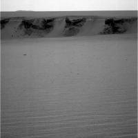
|
|
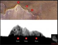
Each column of the image represents one line of sight from Duck Bay across the THEMIS images - each being 0.044 degrees apart (the same as the navcam resolution) the left edge is at 45 degrees (North-East) and the right edge at 180 degrees (South)
At the top is a crop and 5x Phil-o-vision of the image Ustrax posted, According to the tracking site the centre of that image is at 108 degrees so that is where I've placed it - no fudging to make it line up required!
James
Posted by: ustrax Sep 29 2008, 06:48 PM
James...
I like that...a lot!
It looks like I'll have to edit my file again, Hicks should be where Gore is and Gore is the solitary elevation to NE.
I'm sure other views will appear in the following days...
Posted by: Pertinax Sep 29 2008, 07:34 PM
And Explorer / Sofi on the far rim -- four craters martian craters in one image. That has got to be a record of some sort!
-- Pertinax
Posted by: climber Sep 29 2008, 07:53 PM
So James Cook () isn't Rui's Cook, correct ?
Posted by: climber Sep 29 2008, 08:06 PM
I'm pretty sure I already said that somewhere but anyway.
I used to go to New Zealand for quite some years and always had to go to Gisborne ... which is the very place where James Cook first landed in Aotea Roa (Maori's name for New Zealand which means "the Land of the long white clouds"). So let's a feature already visible be called Young Nick's head: http://www.teara.govt.nz/1966/Y/YoungNicksHead/YoungNicksHead/en
After New Zealand I had to go to Kauaii Island and had to go to Waimea ...which is the very place where James Cook landed in Hawaii islands.
So, Endeavour means something very special to me
Posted by: Shaka Sep 29 2008, 09:14 PM
Is it possible that the correct term was not "Young Nick's Head", but rather "Young Nick's Headache" after he drank his "gallon of rum"? 
On a more serious note, Hawaii, was also the termination point of Cook's final voyage, when he got into a disagreement with some of the locals on the Big Island. A stone monument marks the spot on the coast where "Old James' Head" rolled in this initial setback to British diplomacy. Happily, greater successes did follow, as reflected in the Union Jack that still graces one corner of the Hawaiian state flag. The other former colonies of the U.S.A. were not so cordial to British emblems.
Posted by: jamescanvin Sep 29 2008, 09:14 PM
Maybe, but I'm not sure quite how accurate the image will be. There are multiple THEMIS images which don't line up perfectly which will cause an error and I haven't reprojected the navcam image so that will be slightly off. I wouldn't rule out your original guess yet.
) isn't Rui's Cook, correct ?Yes Rui's modified Cook is right, that I am sure of. This analysis points to that hill, as does the different method I used on different images two years ago. To be clear my objection in post 2 was to Rui's original image which he subsequently updated.
Posted by: Bobby Sep 29 2008, 10:52 PM
Does anyone have any idea how deep Endeavour Crater is compared to Victoria???
Is it lower in elevation or downhill compared to where we are at now?
Posted by: Astro0 Sep 29 2008, 11:14 PM
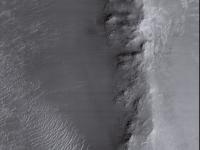
Not sure if this alternate view of Endeavour crater at 8 times vertical exaggeration will assist in this 'endeavour' (pun intended)

|
Astro0
Posted by: Phil Stooke Sep 30 2008, 12:34 AM
That's really nice. You can see how the Meridiani Planum material drapes over the crater's northern rim and fills much of the depression. Those hills on the rim are part of the cratered terrain unit underlying the Meridiani Planum material. It would be a real coup to get to one of the rim hills.
Phil
Posted by: ustrax Sep 30 2008, 06:38 AM
Really, really nice!
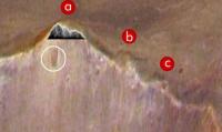
Looking at http://www.unmannedspaceflight.com/index.php?act=attach&type=post&id=13492 (if only I could remember which was the original I have used and how many times I stretched it...) it looks like that we can identify the contour of Cook and the two following elevations to the south. I won't dare to say that I can see the crater in Cook's slope, that is probably an artifact... 
I'll look at this with more attention after having a bath and a coffee...
And James...I don't think that climber was being that technical when he made reference to my "Cook"...
EDITED: Had a bath, had a coffee, had the work done...
Here's what I was talking about:
|
Probably wrong (from James image looks like the three elevations fit all in Cook) but the contour seems to coincide...
You'll also notest that I've named the three features with names previously used in this thread first post (already edited) but I think that it would make more sense to have the three lieutenants together at the "vessel's bridge".
In consequence I had to pick new names for the peaks in the NW, I've took the option of going for the civilians onboard Endeavour, maybe we can follow this line of thought from here on:
NW to NE - The Civilians
SW to SE - The Marines
E - The Crew
Full list http://www2.sl.nsw.gov.au/banks/series_03/crew_01.cfm.
James...are we getting somewhere?
Posted by: Ant103 Sep 30 2008, 08:56 AM
Astro0 : I'm curious to know how do you obtain a such precise elevation of Endeavour? I really enjoy to make simulation in Terragen .
Posted by: djellison Sep 30 2008, 09:12 AM
It's from the HRSCView website - from MEX HRSC data. Honestly, the data really isn't that good.
DOug
Posted by: jamescanvin Sep 30 2008, 10:31 AM
This is a guess, I'm at work and don't have the time or the tools to do a proper analysis so the scale could be well off. But I would say it should be more like this...
|
Posted by: climber Sep 30 2008, 10:45 AM
For quite a while, we're going to extract as much informations of Endeavour's rim as possible from a few pixels.
I wonder if pictures (from Spirit) of the rim of Gusev can be used to better help assuming what is real and what it's not.
I'm sure we can find, in the data base, pictures of Gusev's rim at approximately the same distance, such pictures from the plain could be compared to pictures from the top of Husband's hill. I'm here assessing that the quality from the top is better than from the plain.
Later into the traverse we'll be able to compare some Victoria's features (at least the Beacon I guess) as seen from a distance to what we realy know.
Just a thought.
Posted by: climber Sep 30 2008, 10:49 AM
It's visualy my feeling too... The left ridge of the summit was not matching at all in Rui's proposition but it does here.
Posted by: ustrax Sep 30 2008, 11:14 AM
James is my hero!...
A perfect match! Guess I'll have to restrain myself before posting this ideas without checking the details carefully...
Looks like we've nailed Cook without doubts!:
|
BTW, new navcams and pancams are in, nothing new in the horizon, at least for my eyes, guess the driving guys will be pleased...
Posted by: jamescanvin Sep 30 2008, 12:11 PM
Where would we be without your crazy ideas?

Keep 'em coming - with just a small dose reality we've ended up with your fantastic (and probably accurate
) last diagram.Onwards!
J
Posted by: Astro0 Sep 30 2008, 12:24 PM
Ant103 - "I'm curious to know how do you obtain a such precise elevation of Endeavour?"
Doug - "It's from the HRSCView website - from MEX HRSC data."
Yep Ant, Doug's right - it's from the HRSCView website.
I don't claim to have any magical DEM data at my disposal.
As I've said before, I'm about pretty pictures not the hard science.
I hope too that we get some DEMs for Endeavour, as I'm sure that Doug and yourself will come up with some dazzling images and animations.
Astro0
PS: Glad to see that image might have cleared up the "which peak is that on the horizon?" mystery.
Posted by: djellison Sep 30 2008, 12:45 PM
I've tried using that HRSC DEM for animation - and it's...how can I put this politely.
Not very good.
I'll leave it there.
Posted by: ustrax Sep 30 2008, 02:19 PM
I have no idea...Nicarágua?
Here's the latest development of my work in progress:
|
I'll have one of this on the wall after I give it some retouches...
Posted by: rogelio Sep 30 2008, 02:43 PM
Hypothetical question (and pardon if this is isnt the right thread for it) - Had we known for certain that Opportunity had 5 years and 25 km in her from the start and had we had HiRise pictures of all terrain within 25 km of the landing site, how might the exploration strategy have been different? Would less time have been spent at Victoria, and would she be approaching Endeavour right now? Or perhaps the rover team would have chosen to strike out in an entirely different direction from the landing site/Endurance?
Posted by: djellison Sep 30 2008, 03:06 PM
You could get a million different answers for that. You could say that the purgatory style dunes in HiRISE imagery would have scared them off heading south, so they would have gone in another direction completely. You could say anything really. It wouldn't be any less or more right than any other answer.
Posted by: Stu Sep 30 2008, 03:15 PM
Ustrax,
I have nothing to contribute to this amazing game of "line up the blurs" but I just wanted to say that I don't actually care if none of your names are used in the end, if all of your diagrams turn out to be inaccurate, and all the elevations prove to be hopelessly wrong; with your energy and enthusiasm and passion, having you as our cheerleader for this adventure is like having Willy Wonka showing us around his factory.
Onwards!
Posted by: Ant103 Sep 30 2008, 03:20 PM
( )
Not very good.
Okay. But you already have it. Can I try?
But I will try to make an artificial bump map with picture of Endeavour.
Posted by: djellison Sep 30 2008, 03:43 PM
Why do you need to ask me if you can try? The data's all at the HRSCView website, including an IDL based routine to turn it into easily usable formats.
Posted by: dvandorn Sep 30 2008, 04:01 PM
Ooom-pa!
Ooom-pa!
Tickety-ay!
We're going to Endeavour,
We're on our way!
Ooom-pa!
Ooom-pa!
Tickety-tipple!
Let's hope we don't get
Stuck in a ripple!
-the other Doug
Posted by: Ant103 Sep 30 2008, 04:24 PM
Okay Doug, I misunderstand. Sorry.
Posted by: Phil Stooke Sep 30 2008, 04:34 PM
Wow, Other Doug, I didn't think anybody would be able to top my poem, but you did it!
Phil
Posted by: ustrax Sep 30 2008, 05:08 PM
My friend, I am sure that as soon as the haze in the horizon starts dissipating and the peaks of Endeavour start calling you like a syren you will come up with something...fitting...
Well...it worked http://www.unmannedspaceflight.com/index.php?s=&showtopic=3149&view=findpost&p=67917...
You can say that's part of my charm...can't you?
And it's always a good opportunity to give the others the chance to show what they know...
Ultreya!
Posted by: marswiggle Sep 30 2008, 05:21 PM
Fortunately I long ago downloaded and saved some images of Endeavour peaks from exploratorium, considering that those images no more seem to be available otherwise than in the JPL site. So, I had an idea to make a couple of long baseline anaglyphs of those peaks in the horizon. The stereo baseline is about 50 m, ie. the distance between Oppy's location in sol 950 (right eye images here) and sol 955 (left eye). The baseline is wide enough to clearly distinguish between horizon features, at about 3 km distance, and Endeavour objects, at about 15-35 km distance.
The images are 2x vertically stretched. Hopefully the anaglyph form works to you.

|

|
Posted by: charborob Sep 30 2008, 06:23 PM
Using these images, would it be possible by triangulation to evaluate the distance between Opportunity and the hills, thus confirming (or not) Ustrax's identification?
Posted by: ustrax Sep 30 2008, 06:49 PM
marswiggle! Where have those anaglyphs been all this time?!

Beautiful!
Can you provide the original images?
I am sure we can do something from it...
charborob, I am pretty sure James nailed Cook, the doubt is about the twin peaks, dubbed here Banks and Solander, but if Mr. Canvin got it right once I am following is line of work...
btw...those guys at drivability analisys are way beyond us...we're already there!
Posted by: ilbasso Sep 30 2008, 07:11 PM
In spite of the dusty, cold weather,
We're off to explore more together!
Let's march with the band
(It's one that's unmanned)
To Ithaca! - I mean, Endeavour!
Posted by: marswiggle Sep 30 2008, 07:45 PM
[attachment=15894:1P212969...2393L7M1.jpg]
Beautiful!
Can you provide the original images?
I am sure we can do something from it...
My anaglyphs were made about 5 hours ago if I remember correct
The idea of checking and using those old images just occurred to me when I saw that old strethced image sent by you.I have a bunch of images, all dusty and cobwebby from long storage and in a complete chaos I'm afraid.. But at least I can attach the original ones here. Let's see if they suit in one post.
No they didn't but I'll send another post. (I thought it best to send complete pairs in the case I happen to have both parts of a stereo pair.)
|
|

|
|
Posted by: marswiggle Sep 30 2008, 07:55 PM
|
|
|
|
These include the long baseline images I used (mainly those ending -R1M1 for their better quality).
Posted by: Tesheiner Sep 30 2008, 09:30 PM
One of the peaks can be clearly seen on the today's set of pancams.
http://qt.exploratorium.edu/mars/opportunity/pancam/2008-09-30/1P275913504EFF90%23%23P2356L2M1.JPG
There we go!
Posted by: climber Sep 30 2008, 09:49 PM
There we go!
We've never been so close
Posted by: ustrax Oct 1 2008, 12:13 AM

|
I've tried to make an anaglyph out of it but it didn't seem to work out...at least...we can see it clearer!
And we still have marswiggle images to play around...let me just have some sleep...
Posted by: Phil Stooke Oct 1 2008, 12:53 AM
Rogelio asked if Opportunity might have gone somewhere else if we had known it would last so long. Doug said there were a million possible answers. I will suggest that's not likely.
I have examined the CTX images of the region around the landing site. Truth is, there are no other enticing targets. There's a sort of ghost crater north of the landing site, but nowhere near as interesting looking as Victoria. There's some messy looking etched terrain much further north, but nowhere near as interesting-looking as the band to the south. (Actually, I think the etched terrain looked more interesting than it was.) Regardless of how long the rover might last, south was by far the best way to go.
Phil
Posted by: ElkGroveDan Oct 1 2008, 03:42 AM
I would add to the "if we knew" possibilities, that in hindsight we might have swung to the East around the major dunes, arrived at Victoria sooner and might already be halfway to Endeavor.
Now if only my Delorean time machine would start.
Posted by: Stu Oct 1 2008, 05:48 AM
One for our Cheerleader...

|
Posted by: Stu Oct 1 2008, 01:28 PM
I know Oppy will never reach it, but I still think this mesa/butte/whateveritis down in the southern part of Endeavour deserves a really cool name...
|
Rui..?
Posted by: ElkGroveDan Oct 1 2008, 01:31 PM
How about...Medusa.
Posted by: TheChemist Oct 1 2008, 01:41 PM
I concur. Great name Dan.
Posted by: djellison Oct 1 2008, 01:44 PM
Medusa, whos head Persus gave to......ATHENA (our MER payload!)
Posted by: ustrax Oct 1 2008, 02:09 PM
Is that a challenge?...Accepted!
Jiigurru (Lizard Island)
I see the head of a Varanus Gouldii (sand monitor) poking out from the sand there...maybe just a case of malfunctioning pareidolia... 
And it goes towards what I was thinking about Endeavour's names, the crew for features along the rim and for features inside the crater itself I thought about using names of places visited by the vessel on its journey of exploration.
"To European eyes, Jiigurru appeared almost formidable. In August 1770, during his exploration of Australia's east coast, Lieutenant James Cook wrote, "It is mostly high land very rocky and barren except on the NW side where there are some sandy bays and low land, which last is cover'd with thin long grass trees etc the same as upon the Main(land)".
He was impressed by Gould's sand monitor (Varanus gouldii). "The only Land-animals we saw here were lizards and these seem'd to be plenty which occasioned my naming the island Lizard Island""
From http://www.epa.qld.gov.au/parks_and_forests/find_a_park_or_forest/lizard_island_national_park/lizard_island_national_park_8212_nature_culture_and_history/.
Do you like it?
EDITED: Here I was taking my time doing some serious research ( ) for naming properly this feature and Dan just overthrow the pile of old manuscripts and charts I had on the desk...
Posted by: Tesheiner Oct 1 2008, 02:22 PM
Why not?
Posted by: Stu Oct 1 2008, 03:35 PM
Cos after reaching the rim of Endeavour she's setting off for Valles Marineris, silly...
Posted by: climber Oct 1 2008, 04:53 PM
Rui..?
Stu, please do NOT associate in the same sentence the two words I put in bold in your post
Posted by: climber Oct 1 2008, 04:59 PM
Not sure it is appropriate :

|
Posted by: mhoward Oct 1 2008, 05:03 PM
One of the best (unofficial) names ever...
Posted by: eoincampbell Oct 2 2008, 04:25 AM
Was Ithaca dropped in favor of Endeavor for Big Crater ?
Posted by: Astro0 Oct 2 2008, 06:04 AM
Ithaca is just what we've been calling the big crater for many years (long-time UMSF'ers know who's responsible for that! ) It's also the homebase for Cornell University. Endeavour is the name that the Rover teams have put forward, with the hope that it might become official.
Astro0
Posted by: Astro0 Oct 2 2008, 07:59 AM
Stu, I hope you don't mind, but your http://www.unmannedspaceflight.com/index.php?showtopic=5497&view=findpost&p=127353 stirred me to make up a few new posters using your words.
Enjoy
Astro0

|

|
Posted by: climber Oct 2 2008, 08:27 AM
What will we be without these two ... (not talking about craters )
Posted by: Stu Oct 2 2008, 01:18 PM
Mind? As always, I'm honoured!
Posted by: charborob Oct 2 2008, 04:33 PM
Here are some very rough straight-line distance estimates to Endeavour (names are ustrax's):
- Banks and Solander: 18 km
- closest "rim" (more like a wide bulge): 13 km
- northern tip of western ridge: 15 km
Obviously, because of the weaving between the ripples that Oppy will have to accomplish, the actual roving distance will be greater. I hope she makes it!
Posted by: ustrax Oct 2 2008, 07:54 PM
Astro0, the image in that second poster is simply spectacular! 
Definitely one of my favourites so far!
Are we here yet?...
While Oppy is renitent is saying farewell to Victoria, while the guys in the room next door are looking for solutions for surfing the dunes, while the views towards Endeavour remain there, teasing us, before the long trek, I thought that this would be a good occasion to let myself navigate in historys waves.
Since we are headed to, presumably, visit other craters on the way to our destiny (Mini-Endurance?...), Ive been doing some research, based on the fact that these features are being named after scientific and exploration ships.
Fascinating stories, foggy adventures, an oceanographer king, legends and discoveries have made their appearance along the way and Ive retained the name of few of these vessels who have all the conditions to figure aside the already existing flotilla in Meridianis Sea of Sand.
Here they are, waiting to sail once more...:
-HMS Porcupine
-HMS Lightning
-HMS Challenger
-Talisman
-Travailleur
-Hirondelle
-Princesse-Alice
-NRP Amélia
Who knows if we will hear about them in future sols?...
Posted by: Stu Oct 2 2008, 08:42 PM
Rui... want to share these with you...
Exultation is the going
Of an inland soul to sea,
Past the houses, past the headlands,
Into deep eternity.
- Emily Dickinson
Twenty years from now you will be more disappointed by the things you didnt do than by the ones you did do. So throw off the bowlines. Sail away from the safe harbor. Catch the trade winds in your sails. Explore. Dream. Discover.
- Mark Twain
Posted by: ustrax Oct 3 2008, 07:17 AM
Stu, impossible to imagine this mission without its lyrical side...some may disagree, or found curious all the poems, mottos and utopias but I believe that this is what makes of MER such a "human" adventure.
"Was it worth it? Everything is worth
If the soul is not small.
Who wants to go beyond the Bojador
Have to move beyond the pain.
To the Sea, God gave the danger and the abyss,
But it was there that He mirrored the sky."
Fernando Pessoa - Mar Portuguêz
I'll change some words...
"Was it worth it? Everything is worth
If the soul is not small.
Who wants to go beyond the Purgatory
Have to move beyond the pain.
To Mars, the Universe gave the danger and the abyss,
But it was there that He mirrored the will."
Posted by: Ant103 Oct 3 2008, 07:44 AM
This become a poetry room 
Astro0 : great posters and great verse of Stu.
The idea of leaving Victoria Crater gives me nostalgic feelings. This is why I've made the picture, with name incrustation to the landscape of an end of a sol (bays and a fuzzy Endeavour beyond the horizon).
http://www.db-prods.net/blog/wp-content/uploads/2008/10/lastsolsatvictoria.jpg
Posted by: Stu Oct 3 2008, 08:05 AM
That's really nice, Ant... love the way you've put the name "Endeavour" actually beyond the horizon, I would NEVER have thought of doing that!
On the poetry thing... I sometimes worry about posting mine (or lines from other poems) here, because I am very aware that not everyone "gets it", and some people probably think this isn't actually the place for waxing lyrical about space exploration when it's such a Hard Engineering subject. But I like to think there's room for everyone here: the engineer who takes delight in learning and talking about gear ratios, thresholds and performance limits, etc... the geologist who sees a subtle but serene beauty in the cracks in and planes of a dust-coated rock sitting exposed on the surface... the meteorologist who smiles with understanding when they see cotton wool clouds drifting like Scooby Doo ghosts across the pink martian sky... the dreamer who refuses to accept that something is 'clearly impossible' and pushes the rovers on with the sheer force of their passion... the poet, like me, who can't create scientifically useful driving maps but can, occasionally, string a few words together to illustrate the drama and excitement of this amazing, thrilling time, and help people look beyond the rovers' polished metal to glimpse the very human hearts beating within them...
I know, I know, there I go again. I know they're just robots, lifeless shapes of metal being driven by remote control from far across the solar system, mindless automatons with no feelings, no emotions of their own, and maybe it is silly to write poetry about them, but it makes the hairs on the back of my neck stand up every time I realise that we - mankind - dared to dream we could build such machines, then designed them, built them and flung them across the solar system to explore an alien world on our behalf, and are now seeing Mars through their eyes. I can't imagine how Paolo, Scott and Sharon feel as they sit down to actually drive Spirit and Oppy across Mars, but I do know that they won't just think of it as driving a robot; they're exploring, in the truest sense of the word, and, magically, we're looking over their shoulders as they go...
We might not reach Endeavour. But we might. We just might. But whatever happens, Oppy won't set off on her long drive alone; we'll all be walking alongside her, in spirit at least, keeping her company, trekking south across the great plain of Meridiani towards a new horizon and a new adventure. We'll all find something different to thrill and excite us along the way, making new pictures, writing new poems and creating new maps along the way. And in a hundred years time, when Oppy rests in the Museum of Exploration on Mars, and is seen every sol by hundreds of fascinated visitors, they'll look back on this time and envy us - us! - for accompanying her on her journey.
Posted by: Tesheiner Oct 3 2008, 08:25 AM
True, but they also are the eyes (and minds) of hundreds or thousands of people transported to mars, and this is what makes this journey so great!
Posted by: ustrax Oct 3 2008, 09:48 AM
James, still sleeping?
There's work to be done!
(Pando, are you around my friend?)
Seems like we might be seing some new features in the most recent navcam images:

|
Or not...I'm a bit lost with the change of position...here's the http://qt.exploratorium.edu/mars/opportunity/navcam/2008-10-03/1N276265210EFF90%23%23P0625L0M1.JPG.
Is it possible that, from this point of view, the rightmost feature may be located in the rim closest to Victoria?
Posted by: Tesheiner Oct 3 2008, 10:12 AM
Rui, that image is looking north so not related to Endeavour. http://www.unmannedspaceflight.com/index.php?s=&showtopic=5497&view=findpost&p=127511's a polar projection of the latest navcam shots.
Posted by: ustrax Oct 3 2008, 10:20 AM
I knew I shouldn't have drink that extra cup of coffee...
So...What is it?!

Let's go and have a look?
Posted by: climber Oct 3 2008, 10:55 AM
Stu,
You're so right. Just look at the posts before and after your's. There is technic, there are pictures, there is poetry. Even technic can be emotional. Perfect exemple in only a few posts.
What I love here is the alternance. What I love is: you never know which one you'll get before opening a post.
Posted by: ustrax Oct 3 2008, 11:29 AM
You forgot one...there is also cheerful ignorance!
Posted by: Phil Stooke Oct 3 2008, 11:55 AM
Rui's hill is the big drift fringing Duck Bay. Let's not go back and look at it!
Phil
Posted by: Tman Oct 3 2008, 11:57 AM
Could/should be the rim of the Duck Bay.
Posted by: RoverDriver Oct 3 2008, 05:21 PM
On the poetry thing... I sometimes worry about posting mine (or lines from other poems) here, because I am very aware that not everyone "gets it",
...
Stu, speaking only for myself as usual, I'm one of the few who does not get it. Both because English is not my primary language, and also because I do not appreciate poetry in my native language either. I'm pretty sure that if I sit down with you I can quickly explain any of the technical details that now escape you, but you might spend years and fail to explain to me how to put together words so that they make you feel something.
Your poetry is more than welcome but unfortunately not "grocked" by your truly.
Paolo
Posted by: ustrax Oct 3 2008, 07:01 PM
Paolo, I know that you are on the engineering side of the fence and that I am not Stu but...
Itaca
Quando ti metterai in viaggio per Itaca
devi augurarti che la strada sia lunga,
fertile in avventure e in esperienze.
I Lestrigoni e i Ciclopi
o la furia di Nettuno non temere,
non sara` questo il genere di incontri
se il pensiero resta alto e un sentimento
fermo guida il tuo spirito e il tuo corpo.
In Ciclopi e Lestrigoni, no certo,
ne' nell'irato Nettuno incapperai
se non li porti dentro
se l'anima non te li mette contro.
Devi augurarti che la strada sia lunga.
Che i mattini d'estate siano tanti
quando nei porti - finalmente e con che gioia -
toccherai terra tu per la prima volta:
negli empori fenici indugia e acquista
madreperle coralli ebano e ambre
tutta merce fina, anche profumi
penetranti d'ogni sorta; piu' profumi inebrianti che puoi,
va in molte città egizie
impara una quantità di cose dai dotti.
Sempre devi avere in mente Itaca -
raggiungerla sia il pensiero costante.
Soprattutto, non affrettare il viaggio;
fa che duri a lungo, per anni, e che da vecchio
metta piede sull'isola, tu, ricco
dei tesori accumulati per strada
senza aspettarti ricchezze da Itaca.
Itaca ti ha dato il bel viaggio,
senza di lei mai ti saresti messo
sulla strada: che cos'altro ti aspetti?
E se la trovi povera, non per questo Itaca ti avrà deluso.
Fatto ormai savio, con tutta la tua esperienza addosso
gia` tu avrai capito cio` che Itaca vuole significare.
Kavafis
I don't believe that, even for you, the journey towards Ithaca/Endeavour will reduce itself to find the path, cross the distance and get there, will it?...
Posted by: Bobby Oct 3 2008, 07:10 PM
Hi Ustrax
Where is Pando??? No reply from him Since June
Does anyone know how to contact him?
He's missing out on the new adventure
Posted by: climber Oct 3 2008, 07:18 PM
Itaca
....
Kavafis
I don't believe that, even for you, the journey towards Ithaca/Endeavour will reduce itself to find the path, cross the distance and get there, will it?...
Thanks Rui,
I wish of you all can get the music of this magnificent poem. Every language has its own sounds and give untranslatable feelings.
I'm just in awe at the moment...
Posted by: climber Oct 3 2008, 07:20 PM
Where is Pando??? No reply from him Since June
Does anyone know how to contact him?
He's missing out on the new adventure
Hey Bobby, did you missed this : http://www.unmannedspaceflight.com/index.php?showtopic=5476&pid=127604&st=465&#entry127604 ?
Posted by: Bobby Oct 3 2008, 07:29 PM
Thanks Climber
Yes I did miss that post and thanks
I think Ustrax missed it also
Now Go Oppy
Posted by: RoverDriver Oct 3 2008, 07:56 PM
....
I don't believe that, even for you, the journey towards Ithaca/Endeavour will reduce itself to find the path, cross the distance and get there, will it?...
Absolutely not. What I meant to say is that while I can appreciate a good picture, I typically cannot appreciate poetry, I only wish I could.
Paolo
Posted by: ustrax Oct 3 2008, 08:10 PM
I can understand Paolo, I really can, but if you can just remember the time when there were no pictures...
How would you describe something as amazing as Mars, something that cannot be imprisioned in a picture, like the will to move onwards, to learn, to discover, to see the unseen and know the unknown, to surpass purgatories and face 12kms distant utopias? That is, in my humble point of view something impossible to achieve without one of Mankind's greatest conquests, to, through words, express the beauty and the core of it all.
We're too spoiled by tech...
Posted by: TheChemist Oct 3 2008, 11:45 PM
In view of the publicity Kavafis got in UMSF, it is a bit spooky to realize that another famous poem of his, "http://www.parlandosparlando.com/view.php/id_323/lingua_1/whoisit_1" starts with these very words :
"What are we waiting for, assembled in the forum?"
Posted by: Greg Hullender Oct 4 2008, 01:07 AM
I think I can find at least one example of a deeply moving poem that's at least close to the subject:
And danced the skies on laughter-silvered wings;
Sunward I've climbed, and joined the tumbling mirth
of sun-split clouds, and done a hundred things
You have not dreamed ofwheeled and soared and swung
High in the sunlit silence. Hov'ring there,
I've chased the shouting wind along, and flung
My eager craft through footless halls of air....
Up, up the long, delirious, burning blue
I've topped the wind-swept heights with easy grace
Where never lark nor even eagle flew
And, while with silent lifting mind I've trod
The high untrespassed sanctity of space,
Put out my hand, and touched the face of God.
--John Magee, "High Flight"
I don't know about anyone else, but "High Flight" always chokes me up, and I cannot read it aloud.
That said, I have to say none of the rover poems works for me. The style seems fine, the words seem to be well-chosen, the rhyme and meter are pleasing -- but something leaves me cold. I'd like to say something helpful about that, since I feel Spirit and Opportunity ought to be at least as inspiring as a Spitfire, so I'll say I think the reason the poems leave me unmoved is that they really are just about the two machines. I guess I'm not satisfied with them just being machines -- I want them to be symbols of something much greater. If a rover "feels" something, I don't want it to be an actual physical malfunction -- I want it to be something felt by all of us who want to reach for the stars. I wish I could be more precise.
Yes, I know it's unreasonable to expect something as good as "High Flight." :-) Yet sometimes it doesn't seem like you're that far away from it. Don't mean to offend -- just wanted to offer some feedback that might actually be useful.
--Greg
Posted by: ustrax Oct 4 2008, 06:08 PM
That is a fantastic poem, thank you, personally, for introducing me to it and, although I do not entirely concur with you about Stu's poems, there have been, at least, two poems through which this mission has been fueled by, well, I personally didn't know these so, at least for me, they work as my two favourite works so far...El Dorado by Poe and Ithaca by Kavafis, and these you can't disassociate from the sols we've been through...
Engineering, science, astronomy...man...that without the "pilgrim shadow", that without " what Ithaca means", that without, "Ectasy of Gold" (my own MER soundtrack...) wouldn't mean a thing...
And even if the words don't work out for you I am sure, beyond UMSF there's someone dreaming about an Atkinson's Mars...
TheChemist...don't tell me you have reached that poem only know?!...
Posted by: ustrax Oct 4 2008, 06:51 PM
Just received an e-mail...looks like Jim Bell jgot into the party...
"It is going to be an adventure--if we can make it! Once we finish at the alcoves and promontories of Victoria, we will be starting to routinely take Pancam images in that direction--for a LONG time..."
That sounds like a lot of headaches coming from me to you James, doesn't it?...
And...of course...don't forget http://www.amazon.com/Mars-3-D-Rovers-Eye-View-Planet/dp/1402756208/r...
Posted by: TheChemist Oct 4 2008, 07:03 PM
Well, the english translation of it, yes. I just had a flash realizing agora --> forum --> UMSF,
and it felt weird
Posted by: djellison Oct 4 2008, 09:29 PM
Channel 4 here in the UK had a WW2 veteran read it at the end of an episode of the archeology program 'Time Team' where they found and recovered a Spitfire. I was in floods of tears.
Posted by: Greg Hullender Oct 4 2008, 10:00 PM
In that vein, thinking about Opportinity's trek to Endeavour, have a look at Ulysses by Tennyson:
http://www.victorianweb.org/authors/tennyson/ulyssestext.html
This bit of it is particularly apropos:
Death closes all: but something ere the end,
Some work of noble note, may yet be done,
Not unbecoming men that strove with Gods.
Or maybe it just seems so to someone embarking on a mid-life career change. ;-)
--Greg
Posted by: Shaka Oct 4 2008, 10:12 PM
Made weak by time and fate, but strong in will
To strive, to seek, to find, and not to yield.

Posted by: ustrax Oct 4 2008, 11:27 PM
"...Come, my friends,
'Tis not too late to seek a newer world."
God...I'm in tears...
Posted by: CosmicRocker Oct 5 2008, 06:50 AM
/me wipes a tear from his eye and provides hugs for everyone within reach.
Now, can we get back to science, engineering, exploration, and planetary adventure here? (I'm not totally insensitive to the emotional side of planetary exploration...I actually enjoyed the challenge of reading and trying to interpret all the poetry. Personally, I've been looking for an opportunity to insert some operatic mp3 files into the discussion, but I'd have to guess that Doug might frown on that. )
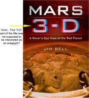
OMG! I've been waiting for that! Do you know when his book will actually be printed? I can't wait to get a copy of it. Currently it can only be pre-ordered.
After Ken asked people to submit 3D images for possible inclusion in the book I began collaborating with another member on a large color anaglyph. I guess it didn't make the final cut, or we would have heard by now. That's somewhat of a bummer, but I'll get over it.
I think there is a problem with the book cover. We may need to get word back to Jim Bell and his publisher regarding the 3D anaglyph affect in the title. The "3-D" portion of the title is printed as an anaglyph, but it appears they got the red and blue parts reversed. Most red/blue anaglyph glasses put the red filter over the left eye, and blue over the right eye. To properly see the 3-D effect on the book cover, one would need to wear their glasses backwardly.
Posted by: Shaka Oct 5 2008, 07:46 AM
Una furtiva lagrima ?
Dies Bildnis ist bezaubernd schön ?
E lucevan le stelle ?
Che gelida manina ?
Posted by: CosmicRocker Oct 5 2008, 07:55 AM
We probably should not go there. I am crying again... Hehe.
Posted by: ustrax Oct 5 2008, 11:59 AM
I remember Jim Bell telling at spacEurope that the book would come out in November, and that is the date also at the Sterling site, but at Barnes&Nobles a more specific date is indicated: December 02.
I've forwarded your words about the anaglyph and the cover to Jim.
EDITED: Here is Jim's notes, it will come out in November indeed:
About the cover:
For all those anxious with the Long Trek, we're almost there...:
Posted by: BrianL Oct 5 2008, 02:52 PM
Marketing opportunity, Tom (no pun intended). In addition to buying the book, you will also have to buy the special proprietary Mars 3-D glasses.
Posted by: CosmicRocker Oct 6 2008, 06:21 AM
Rui: I know the cover of the book is not an anaglyph. That is very obvious. I was only speaking of the "3-D" part of the title on the cover. If that was not intended to appear as an anglyph, I'll eat my cardboard glasses.
I am attaching an annotated image of the cover to illustrate my point. It's probably a very small thing to talk about, but if you are going to create such an anaglyph impression in the cover design, why the heck wouldn't you do it correctly?
|
One would expect the glasses to come with the book. We'll have to see which sides the filters will be on. Posted by: djellison Oct 6 2008, 07:34 AM
There is no wrong-way-round for an anaglyph. One way around suggest closer, the other suggests further. In most Mars anaglyphs - you will find some rocks that look like that logo, and some that look the other way. There is nothing incorrect about that logo at all. You're never going to look at that with the glasses that come with it because they're built into the book itself.
But you know what - I think you might be right. It Does. Not. Matter.
Posted by: Oersted Oct 6 2008, 10:57 PM
It is meant to signal "3-D" to the browsing public in the book shop, not meant to be an actual 3-D text. Only those UMSF fanatics who wear red-green glasses in daily life will be thrown off...
Posted by: CosmicRocker Oct 7 2008, 05:09 AM
Posted by: SFJCody Oct 16 2008, 07:47 AM
Haven't seen these HiRISE views of the rim of Endeavour posted yet.
|
|
Posted by: Tesheiner Oct 16 2008, 08:43 AM
Could you post a link to the source images?
Posted by: djellison Oct 16 2008, 08:46 AM
It's not out yet - they were in Squyres' DPS presentation on Tuesday evening.
Posted by: ustrax Oct 16 2008, 08:51 AM
Feed us!
Posted by: djellison Oct 16 2008, 09:37 AM
It was only taken a week or so ago. I'm hoping the HiWeb guys manage to maybe get it into next weeks release.
Posted by: Tesheiner Oct 16 2008, 10:39 AM
So is this the long awaited image covering the remaining path from "Mini-Endurance" to Endeavour?
Posted by: djellison Oct 16 2008, 12:28 PM
I think this one might be more centred on Endeavour itself, rather than the route. They'll arrive soon enough.
Posted by: briv1016 Oct 17 2008, 08:35 PM
I'm not sure if anyone has read Emily's Blog:
A shift in orbit for Mars Odyssey
http://www.planetary.org/blog/article/00001698/
Posted by: djellison Oct 17 2008, 09:06 PM
http://www.unmannedspaceflight.com/index.php?showtopic=5539
Posted by: briv1016 Oct 18 2008, 02:14 AM
Yea, but that area doesnt get too much foot traffic so I posted it here. And it is going to be factor in the drive to Endeavour.
Posted by: CosmicRocker Oct 18 2008, 05:08 AM
Thanks for posting the teasers. I can hardly wait until next week...
Is http://dps08.astro.cornell.edu/AAS_WebcastSchedule_2008.html one of the places we need to watch for the archived presentations to appear?
Thanks. I usually follow Emily's blog closely, but have been busy lately and missed that. I'd say it is going to be a factor in more than just the Endeavor Campaign.
Posted by: jekbradbury Oct 18 2008, 01:59 PM
The presentations still exist; the index page doesn't. However Google still has a copy of that, too: http://64.233.169.104/search?rlz=1C1CHMP_enUS291&sourceid=chrome&ie=UTF-8&q=cache:http://dps08.astro.cornell.edu/AAS_WebcastSchedule_2008.html. Save this page to your computer if you want to watch more presentations, as the Google version may disappear soon as well.
Posted by: volcanopele Oct 21 2008, 06:01 AM
Is Endeavour located at 2.28S, 5.23W? In which case, Endeavour is now the officially approved name for the crater Opportunity is driving to:
http://astrogeology.usgs.gov/HotTopics/index.php?/archives/345-Martian-Crater-Named-Endeavour.html
Posted by: TheChemist Oct 21 2008, 07:48 AM
http://www.unmannedspaceflight.com/index.php?showtopic=5562&view=findpost&p=129085
Posted by: eoincampbell Oct 28 2008, 04:10 AM
Are we now waiting on HiRISE Endeavour Route and Oppy images due to Odyssey-MRO transition?
Posted by: Station Feb 23 2009, 02:07 PM
Not very good.
I'll leave it there.
I wonder how many meters has the huge east-side internal wall, i mean when we count from the bottom of the wall to cook peak... 200m ? less, more? In comparison Victoria crater with its walls look pretty small in this image.
Posted by: marswiggle Feb 24 2009, 02:28 AM
Using Google Earth (Mars), I was able to pinpoint the lowest and highest points of Endeavour pretty easily. Remarkably, the lowest point (-2006 m) seems to be located just at the base of the eastern wall, 3.65 km due west of its highest point (-1309 m). So the east wall is quite dramatic, and actually about as high as Victoria Crater would be if tossed onto its side, its minor axis pointing up. (If you can imagine that.)
Coordinates:
lowest point - 2˚22'22" S, 5˚04'53" W
highest point - 2˚22'23" S, 5˚01'10" W

|
Posted by: Station Feb 24 2009, 07:45 AM
So, the difference between the lowest point and the Cook Peak is about 700 m. And how many degrees has wall's inclination ?
Posted by: centsworth_II Feb 24 2009, 08:55 AM
Plugging numbers for side c and side b into this online trig calculator, I get an average slope of 11 degrees.

|
Posted by: volcanopele Feb 24 2009, 09:09 AM
That's not too bad. Certainly hike-able without too many problems. And certainly, Opportunity has had to deal with worse slopes at Endurance and Victoria, right?
Posted by: Station Feb 24 2009, 09:30 AM
11 deg only ? At first look the slope seems to be much more dramatic, at least on those 3-d generated pictures.... Well, now I can see those simulated 3-d pictures don't match reality..
You r right volcanopele, in such case Opportunity should have no problems to "climb" there. In Endurance crater there our brave rover had to deal with worse case.
Posted by: centsworth_II Feb 24 2009, 09:45 AM
Looking at the 3d image, the slope seems flatter near the bottom of the crater and steeper near the rim. The 11 degrees is an overall average. Maybe separate calculations could be done for the lower and upper parts.
Posted by: Oersted Feb 24 2009, 03:34 PM
Is that slope anywhere near where Oppy might arrive? - And how is the drive down from a sun angle perspective?
700 meters: that is one heck of a stratigraphic cut...
Posted by: Fran Ontanaya Feb 24 2009, 04:31 PM
You can generate http://www.franontanaya.com/blog/wp-content/uploads/2008/09/hrsc_endeavour_crater_elevation.png and http://www.franontanaya.com/blog/wp-content/uploads/2008/09/hrsc_endeavour_crater_slopes.png 3D maps with HRSC View.
Posted by: ElkGroveDan Feb 24 2009, 05:05 PM
And we ought to hang our heads in shame that we no longer accept the challenge to do this kind of thing on paper, with a quick glance at the trig chart pinned above our desks.
Posted by: ilbasso Feb 24 2009, 07:30 PM
Does anyone still have their CRC log table books?
Posted by: PDP8E Feb 24 2009, 09:02 PM
I still have my Chemical Rubber Company (CRC) book of logs around.....
Posted by: Floyd Feb 24 2009, 09:09 PM
Yes I still have it. Didn't even toss it out when I got my handy HP35 calculator for $360 (ordered it before it was actually released).
Posted by: Greg Hullender Feb 25 2009, 12:52 AM
Ah, but is your trig table old enough to have versines and haversinies too?
--Greg :-)
Posted by: Floyd Feb 25 2009, 01:03 AM
Am I correct in that haversines were used extensively in setting up the curves in railroad tracks? I'm old, but wasn't around in the 1850s.
Posted by: Enceladus75 Feb 25 2009, 01:41 AM
I'm just wondering that as Oppy gradually approaches Endeavour, and since it was able to glimpse tiny parts of that crater's rim from Victoria, then surely some more of Endeavour's rim peaks must be coming into view now?
I'm a sucker for distant views on Mars of mountains and hills. So does anyone know of any images taken by Oppy in the past few days showing parts of Endeavour?
Posted by: CosmicRocker Feb 25 2009, 05:54 AM
On sol 1797 Opportunity captured a series of pancam subframe images looking to the east for a glimpse of Endeavor's northern rim. Those images were described as "pancam_endeavor_look_R12." This was briefly discussed in another thread here, but since none of us were able to detect Endeavor's peaks in any of the raw jpegs, the discussions have since moved on to other subjects. Considering why Endeavor's northern rim was not apparent in the sol 1797 images, I think Opportunity is currently at a lower elevation than it held at Victoria. She is also immersed in a sea of ripples, drifts, and purgatoids impeding the view toward the horizon.
I suspect there will be more attempts to catch a glimpse of Endeavor along the way. In the meantime, we'll have to wait for the next attempt, or a fortuitously positioned pancam along the way.
Posted by: fredk Feb 25 2009, 06:46 PM
I agree that we may be at a lower elevation now than when we had views to Endeavour. Alternatively, we may have moved far enough south that a subtle ridge is now blocking our view towards the east.
You can see this quite clearly in recent navcams. This is a recent view northwards. We can still see the Beacon, and the horizon "looks" very far away, because of its smoothness:
http://marsrovers.jpl.nasa.gov/gallery/all/1/n/1806/1N288520413EFF98J5P1625R0M1.JPG
This is a typical current view towards the southeast:
http://marsrovers.jpl.nasa.gov/gallery/all/1/n/1803/1N288248985EFF98BSP0725R0M1.JPG
By the roughness of the horizon, and knowing the scale of the dunes, the horizon looks much closer in this direction than it does to the north.
This roughness of the horizon is harder to see directly east, since we're looking across the ripples, but I believe it's still there and the high, close horizon is blocking our view to Endeavour.
So perhaps after we turn and move eastwards for a while, we'll crest the subtle ridge and get a "heck of a view" towards Endeavour...
Posted by: BrianL Feb 25 2009, 06:51 PM
I'm waiting for the day we can look back and see the Beacon on the FAR rim. 
OK, I'll let it go now.
Posted by: CosmicRocker Feb 26 2009, 05:47 AM
fredk: I didn't find the time to check Google Earth/Mars when I posted my comment last night, but I did tonight. It appears that they used interpolated MOLA data to define the elevations for the 3D model of Mars. That's not a surprise. A very useful feature of the software is the Lat/Lon/Elev readout of your cursor's position at the bottom center of the view. Tracing Opportunity's route SW from Victoria (with Eduardo's trace as a guide) using my cursor shows that the rover has traveled both below and above the highest elevation of Cape St. Mary along the way. As of sol 1806, Opportunity apparently was a few meters higher than The Beacon.
There does seem to be a subtle ridge to the east, but it seems to be only a few meters taller than the generally local elevations.
Posted by: Tesheiner Feb 26 2009, 07:19 AM
You may also change some preference settings on GE to exaggerate the heights...
Posted by: Phil Stooke Mar 4 2009, 04:53 AM
Here are the Endeavour hills as seen in today's images. It's a merge of three images, enlarged by a factor of two.
Phil

|
Posted by: Stu Mar 4 2009, 08:25 AM
Thanks Phil!
Land Ho!!!!!
(Which image is that cropped from, btw?)
Posted by: ustrax Mar 4 2009, 09:18 AM
Stu, I believe this is the one:
http://qt.exploratorium.edu/mars/opportunity/navcam/2009-03-03/1N289219050EFF98PYP1625L0M1.JPG
Posted by: Stu Mar 4 2009, 09:38 AM
Obrigado, Rui!
Posted by: kenny Mar 4 2009, 10:36 AM
Twin Peaks or what?! Alluring, beckoning out of the haze.... looking forward to seeing them closer.
I take it that, relative elevation-wise to their surroundings, they are the highest thing we've seen so far on Mars (incl. Columbia Hills, Pathfinder's own Twin Peaks, etc, but perhaps not the distant view of Gusev rim)?
Posted by: Phil Stooke Mar 4 2009, 11:51 AM
Rui is correct, except that I cropped it from all three images in that set and merged them.
Phil
Posted by: jamescanvin Mar 4 2009, 01:01 PM
Don't count on it. Those peaks are on the north section of Endeavour - almost due east from Oppys current position.
She is headed to the west rim and with the route we are taking I don't expect her to get significantly closer to those peaks.
Don't worry though, I'm sure we'll get some very alluring peaks to aim at sometime soon.
Posted by: Stu Mar 4 2009, 01:22 PM
Thanks to Phil for giving me permission to use his pic in my blog post, here:
http://cumbriansky.wordpress.com/2009/03/04/the-trek-to-endeavour-land-ho
Looking forward to even better views of other peaks and features in the future
Posted by: ustrax Mar 4 2009, 02:11 PM
Stu, from your blog: "other people have suggested Endeavours Hills have been vaguely visible on previous Oppy images - but I think its our best sighting so far of the distant shore that is Endeavour Crater."
Hum...aren't you forgetting some views we've seen a long time ago here at UMSF?...
I know James...the matching lines are not to take in consideration...
http://i16.photobucket.com/albums/b14/ustrax3/ithaca3.jpg
http://i16.photobucket.com/albums/b14/ustrax3/ithaca2.jpg
And last but not the least...
http://www.unmannedspaceflight.com/index.php?act=attach&type=post&id=13492
Posted by: Stu Mar 4 2009, 02:17 PM
Hum...aren't you forgetting some views we've seen a long time ago here at UMSF?...
Um, no, I'm not forgetting them; those are the views I'm referring to!
But I think you'll agree that this is the first time that the hills have actually been visible to non-UMSFers, right there on raw images, without having to be stretched on the image processing rack...
Posted by: jamescanvin Mar 4 2009, 02:43 PM
I'm with Rui on this one - If anything the 'Twin Peaks' are less distinct now than when we were at Victoria.
They are quite hazy now, but look at the http://qt.exploratorium.edu/mars/opportunity/navcam/2008-09-26/1N275637037EFF90VYP1663R0M1.JPG in post 1 of this thread they are quite distinct, as is 'Cook'. Of course the added hazyness does give a better impression of distance.
Doesn't really matter though does it, it's just nice to have them back on the horizon again.
Looking forward to seeing 'Cook' again as well sometime - it'll be nice to have a beacon on the far rim for a change.
Posted by: Stu Mar 4 2009, 02:47 PM
B****r. Forgot about that great image for some reason. Doh! You're both absolutely right, of course, thanks for pointing it out. I''ve amended my blog piece accordingly.
Posted by: Floyd Mar 4 2009, 04:15 PM
The Rui linked image---What a shot, three craters rims in a row, each a log or two bigger than the one in front.
Posted by: MahFL Mar 4 2009, 04:27 PM
I remember when Victoria crater was but a couple of pixels on a image.
Posted by: ustrax Mar 4 2009, 04:43 PM
So do I...
http://qt.exploratorium.edu/mars/opportunity/pancam/2006-04-26/1P199295742EFF69NVP2396R2M1.JPG
Posted by: ElkGroveDan Mar 4 2009, 04:56 PM
I remember when we were trying to identify Erebus. I must say, for me that was the worst part of the journey thus far.
Posted by: ustrax Mar 4 2009, 05:34 PM
Just playing with that latest pancam, probably just artifacts but isn't it possible that we're also able to see Cook looming over the horizon over there?

|
Regarding the feature on the middle I have even more doubts, guess that the elevation to the left of Cook I've marked is well below the horizon from this point of view...as I've said probably just an artifact or a dune but, if not, we're seing something new...
Posted by: jamescanvin Mar 4 2009, 06:05 PM
Which pancam is that? Twin peaks and Cook are far to far apart to appear on the same pancam image.
EDIT: Actually, given how hazy the Twin Peaks are, we may struggle to see the more distant Cook at this time.
Posted by: Tesheiner Mar 4 2009, 06:59 PM
I assume those are from today's batch. In that case they are the "drive direction" images and those pictures are pointing to the south.
Can't be Endeavour, sorry.
Posted by: ustrax Mar 4 2009, 07:50 PM
Nope, the image was the same Phil used.
As I've said probably just a couple of artifacts...
Posted by: fredk Mar 4 2009, 08:12 PM
It's great to see Endeavour on the horizon again! And, since we've been reminding ourselves of old shots of the rim of Endeavour, we can't forget that we got some stunning pancam views from Victoria:
http://marsrovers.jpl.nasa.gov/gallery/all/1/p/950/1P212524402EFF76CNP2386R1M1.JPG
http://marsrovers.jpl.nasa.gov/gallery/all/1/p/950/1P212524613EFF76CNP2386R1M1.JPG
Posted by: imipak Mar 4 2009, 09:02 PM
And how appropriate that Phil-o-Vision strikes once again in recovering New Beacon first. I can't express how happy I am there's no question about which side of Endeavour we're looking at
Posted by: Stu Mar 4 2009, 10:35 PM
Jeez, did I fall asleep for a week or something?!?! I don't remember seeing those at all!!!!!
Great views. Can't wait to see more and more detail coming into view as Oppy steams towatrds Endeavour. This is going to be one heck of a ride... Posted by: marswiggle Mar 4 2009, 11:23 PM
Just a gentle reminder... those pancams already posted earlier in this thread (originally downloaded from exploratorium some time 2006) http://www.unmannedspaceflight.com/index.php?s=&showtopic=5503&view=findpost&p=127264
Posted by: HughFromAlice Mar 5 2009, 04:24 AM
UMSF is becoming such a huge and comprehensive resource that it is easy to not be aware (or forget)
something that was posted earlier and so duplicate it in a new post!
Posted by: Oersted Mar 5 2009, 02:31 PM
This RAW really is one of the great ones we've had coming down from Opportunity:
http://qt.exploratorium.edu/mars/opportunity/navcam/2008-09-26/1N275637037EFF90VYP1663R0M1.JPG
Three craters in the same shot, each one bigger than the other by a factor of... well, what actually? - help me out here!
Posted by: fredk Mar 5 2009, 03:13 PM
No better way to answer than to direct you back to http://www.unmannedspaceflight.com/index.php?s=&showtopic=5503&view=findpost&p=127138
Posted by: Oersted Mar 6 2009, 12:03 AM
Good, point, so 7, 700 and 22000 meters across...
Posted by: Floyd Mar 6 2009, 12:20 AM
Or log ratios of 2.0 & 1.49. Definitely between 1 and 2 logs.
Posted by: Stu Mar 15 2009, 02:21 PM
The faraway Hills of Endeavour in colour...

|
Posted by: climber Mar 15 2009, 06:13 PM
I agree... the foreground is in colour
It's getting better and better as shown here and in today's download.
Thanks Stu (anyway...)
Posted by: Stu Mar 15 2009, 06:35 PM
Tough crowd tonight, I was really pleased with that!
Posted by: Geert Mar 16 2009, 02:43 AM

|
Does anybody have any idea what those black sediments can be on the southwesterly part of Endeavour crater?
They look like large hills of some sort but they are very dark, far darker then anything in the HiRISE image. However on CRISM they do not seem to really stand out from their surroundings, except in infrared.
They are probably within reach for oppy, even on 5 wheels, but it's a long way down and she will need to make a detour to avoid some nasty dunes further up.
Posted by: Reckless Mar 16 2009, 10:27 AM
They look like sand dunes (a bit barcany) and dark often means basalt.
Roy
Posted by: BrianL Mar 16 2009, 12:16 PM
Could be an abyss.
Posted by: ustrax Mar 16 2009, 12:54 PM
Don't tempt me...
Posted by: Phil Stooke Mar 16 2009, 01:21 PM
Reckless is right, they are large barchan dunes, and probably made of basalt sand. They are quite common around Mars and very distinct from the smaller bright features we see everywhere. Dunes are complicated, and differences in grain size, density, wind speed etc. can sort fine materials in a variety of ways.
Phil
Posted by: Juramike Mar 16 2009, 02:57 PM
Their location might be related to a changing wind pattern. Zooming out (in Google Earth 5.0) one can see that there are dunes just to the W and SW where the long axis seems to vary as one goes around the rim of the crater.

|
Just beyond this curve (and just outside the image) is the talus slope and SW wall of Endeavor crater.
Posted by: Geert Mar 16 2009, 04:22 PM
I was indeed also looking at those dunes on the crater rim above the black hills. Not only does the wind direction seemingly change, but also the dunes themselves come in what looks like three separate bands, each of them different from the other. These dunes differ a lot from the dunes we have been crossing to/from Victoria, and they seem to have more in common with the dune patterns on the floor of Victoria crater. Quite short 'wavelength' and all completely entwined with lots and lots of cross-dunes everywhere, it definitely doesn't look like a 'friendly' area to enter but fortunately there are enough options to avoid them.
If there is a wind pattern which results in basaltic sand ending up on the SW rim, then it remains weird why these hills should be so very sharply defined, hardly any sand seems to be spilling 'outside' of these hills, they have very sharp edges and don't seem to have much in common with the landscape around them. Mars remains a fascinating place, time and time again ;-).
Posted by: Shaka Mar 16 2009, 09:33 PM
The winds prevailing through this area in recent years (millennia ?) are probably just below the velocity threshold to set the surface dust layer moving. At the edge of the dune the winds are deflected upward and, hence, accelerated, as with the leading edge of a plane wing aerofoil. The resulting velocity and 'lift' is enough to strip off the fine, rusty dust that sticks to the adjacent level plains. Thus only clean, coarse basaltic sand grains are left to cover the dune. These are great light traps, better even, and darker than, a solid plate of basalt. There probably is similar black sand in the adjacent plains, but coated with red dust.
Posted by: Sunspot Mar 16 2009, 09:59 PM
Isn't Endeavour Crater a bit of an optimistic destination now?
Posted by: ngunn Mar 16 2009, 10:13 PM
Yes, but not the first. Life's just one optimistic destination after another.
Posted by: BrianL Mar 16 2009, 11:22 PM
It was always an optimistic destination. That doesn't mean it wasn't, or still isn't, an achievable destination. If I had to pick between the likelihood of Oppy reaching Endeavour or Spirit reaching Von Braun,... well, maybe we just shouldn't go there.
Posted by: RoverDriver Mar 16 2009, 11:42 PM
Let's not go there, but think at how Victoria was seen when we left the heat shield. It looked just as far and just as unreachable.
Paolo
Posted by: Geert Mar 17 2009, 11:20 AM
Thanks for the explanation!
I accidently stumbled on what looks like exact the effect you mention in MOC image M1900278 around 45.02 S and 202.27 E (close to the supposed Mars 3 landingsite), here the topsoil of the dunes seems to have been blown away, exposing black basalt, which is also present in other places in the same area.

|
Difference is that at the Meridiani ripples on the route of Oppy, the top of the dunes seem to be mostly brighter then the average terrain and the same seems to be true for the dunes inside Endeavour, so these hills of basalt sand look a bit more like a local feature or maybe the basalt is hidden deeper underneath the dunes.
Posted by: Juramike Mar 17 2009, 01:27 PM
Another possibility is that medium-strength winds are blowing dark basaltic sands all across the plain (I'm pretty sure I read this in Sullivan et al. see post http://www.unmannedspaceflight.com/index.php?s=&showtopic=5476&view=findpost&p=131765).
Endeavour Crater could be a really big basaltic sand trap. The grains go in, but they don't come out. (And even if they do escape, they diffuse/dilute out quickly and are not evident). The lower strength winds pile them on top of each other and concentrate them into a dune pile. (like the dune patch in Death Valley).
Couple this up with the dust explanation by Shaka (lighter winds required to move the dust), and I think it's a good possibility for what we see here.
-Mike
Posted by: remcook Mar 18 2009, 08:19 AM
mmm those black pixels look really black and contrastless. I would think those are artefacts somehow, but don't see why they are so neatly aligned on the dunes.
Posted by: paxdan Mar 18 2009, 12:01 PM
I'd say they were saturated pixels and the software, upon registereing a max value, is showing them as black. If the max vaules were displayed as white the image would be closer to the actual view.
Posted by: Geert Mar 18 2009, 04:21 PM
You might be right, but I'm not completely sure of that. These ripples are on a crater floor and there is a lot more of this black stuff higher up on the crater walls and on the rim of the crater, they all look similarly black/featureless so either they are all saturated pixels or it's really black sand/dust blowing into the crater and getting stuck on the ripples.

|
Full image is MOC M1900278
Posted by: pgrindrod Mar 18 2009, 04:50 PM
hi Geert,
it looks like a saturation effect to me too. if you go to the MSSS image page http://www.msss.com/moc_gallery/m19_m23/images/M19/M1900278.html, you can have a look at the map projected image, which is pretty bright in the areas you've highlighted.
here's a crop of the map-projected (medium quality) image of roughly the same area as your image. it doesn't look to me as if there's any dark stuff blowing about in this area.

|
pete
Posted by: Geert Mar 18 2009, 05:29 PM
You're right Pete, it's indeed not in the processed image, I was using the unprocessed version, so it must be a saturisation effect.
One more riddle solved thanks to UMSF
Posted by: Phil Stooke Mar 18 2009, 07:49 PM
... and for more on those big dark dunes check this out:
http://marsprogram.jpl.nasa.gov/mro/gallery/press/20090317a.html
Phil
Posted by: Juramike Mar 18 2009, 08:09 PM
Thanks Phil!
BTW, clicking on the large version of the image brings out the fine ripple detail on the dark dune itself.
It is just beautiful!
Posted by: fredk Mar 19 2009, 03:57 AM
In http://marsrovers.jpl.nasa.gov/newsroom/pressreleases/20090318a.html, it is stated:
This is funny - we just had this discussion a few pages back in this thread. It seems some of us weren't the only ones who forgot about the superb imagery of the Endeavour rim we obtained from Victoria way back around sol 950 (almost 900 sols ago!), not to mention the many views we've had since!
Posted by: mhoward Mar 19 2009, 04:13 AM
Not to mention the many views well before Victoria. Funny, though.
Posted by: Stu Mar 19 2009, 07:51 AM
True, some of us did forget, but the big difference now is that we're actually heading *towards* those hills, rather than just spotting them on the horizon whilst doing something else.
Posted by: jamescanvin Mar 19 2009, 08:30 AM
Well Stu, I would argue that as we left Victoria we could see Endeavour and were heading towards it.
I think the big difference now is that we can see the west rim - the actual bit we are heading for. Back at Victoria, we could only see the north and south-east sections that are a LONG way from where we are actually going.
Posted by: Stu Mar 19 2009, 08:50 AM
Fair enough. Definitely having a "Jeez, wish I'd never said anything now..." moment...
Personally I'm just buzzed whenever we get a glimpse of something new on the horizon. That's the true wonder of this mission. We keep seeing one "something new" after another.
Posted by: mhoward Mar 19 2009, 02:00 PM
Good point. So what they wrote is accurate when read in a certain way.
Not sure if this has been noticed already, but they've labelled what they're seeing in some http://marsrovers.jpl.nasa.gov/gallery/press/opportunity/20090318a.html: North Rim of Endeavour, East Rim of Endeavour, and "West Rim of Endeavour and a Farther Crater's Rim", specifically Iazu Crater.
Posted by: Geert Mar 19 2009, 02:16 PM

|
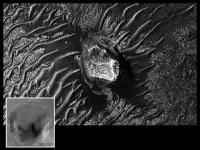
Is this a single large stone on the SSW wall of Endeavour, or is it a crater with bedrock?
If it is a stone then this must be the cobble they were looking for, thing must be really big.
Posted by: fredk Mar 19 2009, 02:19 PM
Sorry to be putting corrections on top of corrections, but I don't believe we've heard anything official about our first destination at Endeavour. The west rim is certainly the most obvious guess, but we've had mention of http://www.unmannedspaceflight.com/index.php?s=&showtopic=5702&view=findpost&p=136985 In reality, perhaps a decision may not be made for some time.
Also, I was skeptical that we couldn't see the new piece of the west rim from Victoria, especially when we had those great views around sol 950. Looking again, I'm pretty sure it is visible, for example in this frame on the far right horizon:
http://marsrovers.jpl.nasa.gov/gallery/all/1/p/950/1P212524801EFF76CNP2386L7M1.JPG
The shape looks a bit different now, but then the parallax is greatest for this closest bit of rim. The azimuth is about right.
Anyway, I agree with an earlier post, that there seems to be something hard-wired in us to want to squint and try to see what's coming up on the horizon. I can't wait to see more and more appear...
Posted by: jamescanvin Mar 19 2009, 02:46 PM
I think your right - but frankly I'd be astonished if we didn't end up on the west rim. If we're going to the twin peaks we are REALLY going the long way around. And if we are going to the FAR rim then surely we'll swing by the near rim first!
Must be one of the three, as SS says we can now see where we are going:
Thanks for that. I didn't remember seeing it before (although that feature does look familiar now you post it)
Can't wait to see more and watching them get bigger and bigger.
Posted by: ustrax Mar 19 2009, 04:04 PM
That's http://www.unmannedspaceflight.com/index.php?s=&showtopic=5503&view=findpost&p=127335...
or Medusa, or Athena, or...well...you name it...
EDITED: Could someone point me on a map where exactly is that piece of the west rim mentioned by fredk? Thanks!
Posted by: fredk Mar 19 2009, 05:17 PM
http://marsrovers.jpl.nasa.gov/gallery/press/opportunity/20090318a.html include an orbital view with all three pieces of the rim identified as well as Iazu (see annotated version).
And thanks for reminding us of those older posts, Ustrax. I loved your expression "malfunctioning pareidolia"!
Posted by: Station Mar 23 2009, 08:42 AM
|
|
Is this a single large stone on the SSW wall of Endeavour, or is it a crater with bedrock?
If it is a stone then this must be the cobble they were looking for, thing must be really big.
I'm not quite sure but it looks like a butte, this isolated hill with flat top and vertical sides - such common rock formations in Monument Valley.
Posted by: kenny Mar 23 2009, 09:55 AM
It is surely a butte, illuminated from the west (left), even though the ripples don't show shadows enough to confirm the illumination angle
Posted by: imipak Mar 23 2009, 08:04 PM
The shape reminds me of http://images.google.com/images?hl=en&q=longstone%20staunton&gbv=2 of dubious provenance, but "Long Stone" would be a pretty insipid name. How about "...Stone'enge!" ? (the ...pause, and the exclamation mark, are vital for http://www.youtube.com/watch?v=WXGbwIkvh38)
Posted by: fredk Mar 23 2009, 09:42 PM
To me the feature looks more like a partially buried crater with dark sand piled along the east (left) side. I can almost make out part of the rim along the top.
We may have to wait for a second stereo hirise frame to settle this. Time to start another Great Debate? 
Posted by: AndyG Mar 23 2009, 09:54 PM
Can Oppy be turned up to eleven in order to get there quicker?
Andy
Posted by: Bill May 28 2009, 10:11 AM
Long, long time reader but first post.
Look at the horizon ! What a view.
http://qt.exploratorium.edu/mars/opportunity/pancam/2009-05-27/1P296679391EFFA13AP2356R1M1.JPG
Maybe after visiting Endeavour...
Posted by: Phil Stooke May 28 2009, 10:27 AM
That's great - lots of new features coming into view. Thanks for pointing it out.
Phil
Posted by: mhoward May 28 2009, 12:56 PM
That... is amazing. The left-camera view is good too: http://nasa.exploratorium.edu/mars/opportunity/pancam/2009-05-27/1P296679391EFFA13AP2356L6M1.JPG
Adding: And that's one of the drive-direction images.
Posted by: ustrax May 28 2009, 01:22 PM
Wow!...
Here's a noisy, aligned horizon, 6x stretched view:
|
|
Posted by: Tesheiner May 28 2009, 04:07 PM
My first impression was: "why would someone ressurrect an old thread to point out the hills we have already seen since VC?".
But then, after "focusing my eyes", I said to myself: "wait! wait! what's THAT!!!"
Great catch, Bill! And welcome to UMSF.
Posted by: Hungry4info May 28 2009, 06:00 PM
Are these faint distant hills the other side of the Endeavour rim?
Posted by: BrianL May 28 2009, 06:03 PM
Whoa, I'm starting to feel like we've finally made it across Saskatchewan and are heading into Alberta.
Posted by: Oersted May 28 2009, 06:06 PM
Look at the horizon ! What a view.
http://qt.exploratorium.edu/mars/opportunity/pancam/2009-05-27/1P296679391EFFA13AP2356R1M1.JPG
Maybe after visiting Endeavour...
Oh wauw, the OTHER side!
Posted by: jamescanvin May 28 2009, 06:23 PM
What we are seeing are more parts (almost the whole rim!) of Iazu crater beyond and to the right of Endeavour. (The less hazy bit on the left is the near rim of Endeavour)
Here is the left and right pancams stacked, enhanced and stretched 3x with one of my 'inverse polar' images (each vertical column of pixels is one line of sight from our current position. Alignment using the pancam tracking data.

|
James
Posted by: Phil Stooke May 28 2009, 06:45 PM
"Whoa, I'm starting to feel like we've finally made it across Saskatchewan and are heading into Alberta. "
Right on! In fact we must be getting near Calgary.
Phil
Posted by: ElkGroveDan May 28 2009, 07:28 PM
We're 2/3 of the way from San Antonio to Fort Stockton on our drive to El Paso. (if you want to talk about about long, awful drives)
Posted by: Phil Stooke May 29 2009, 01:12 AM
Here's my version. Six frames - two wide, three layers to reduce noise a bit, with a bit of my patented vertical exaggeration. It will be nice to get the clean images from PDS later!
Phil
|
|
Posted by: CosmicRocker May 29 2009, 06:03 AM
Thanks for the contrast enhanced views, people. I thought I was seeing those more distant hills in the raw jpegs, but never got around to messing with the images myself.
Posted by: serpens May 29 2009, 06:40 AM
Yep, and the last service station was how many millions of miles back down the road?
Posted by: Ipparchus May 29 2009, 11:26 AM
Can anyone give me a mineral map of the rim of Endeavour (where Oppy is going to explore)? Squires said that the rim of Endeavour crater has a very different composition from what Oppy has seen so far in her mission, because the rim is made of very ancient terrain. What are we going to see there? basalts, water-related bedrock or something else? 
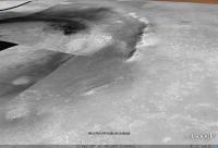
|
Posted by: Fran Ontanaya May 29 2009, 12:30 PM
The CRISM maps are here:
http://crism-map.jhuapl.edu/details.php?data=frt_webmap_polygons&shape=3743&x=-5.261&y=-2.388585
Posted by: Enceladus75 May 30 2009, 03:25 AM
That is just fantastic. To finally see proper topography at dead flat Meridiani is a real treat.
It reminds me of Spirit's first amazing shots of the distant rim of Gusev, just barely visible. I really hope over the coming days and weeks, Oppy will take more and more detailed images of the distant rim of its destination: Endeavour.
Posted by: fredk May 30 2009, 04:17 AM
Once we turn towards the east we should see much more regular drive direction pancams of Endeavour. And as we head into winter the air should clear. So we've got lots to look forward to...
Posted by: Ipparchus May 30 2009, 03:51 PM
http://crism-map.jhuapl.edu/details.php?data=frt_webmap_polygons&shape=3743&x=-5.261&y=-2.388585
This link doesn`t work... what should I do? Thank you!
Posted by: jamescanvin May 30 2009, 04:26 PM
Wait and then try again. It worked yesterday when Fran posted it - the whole jhuapl.edu domain appears to be down at the moment.
Posted by: Fran Ontanaya May 30 2009, 05:31 PM

|
This is one. I think red was olivine or iron philosilicates, green was low-Ca pyroxene and blue high-Ca pyroxene.
Posted by: fredk May 31 2009, 12:01 AM
This new view includes the west rim of Endeavour, which is the closest bit. Since we first got a good look at the west rim, we've moved about one km south. That's enough to get a long baseline 3D view. Here's a flicker gif combining the pancam views from sol 1826 and 1898:

|
Posted by: Floyd May 31 2009, 11:58 PM
ustrax--how close are we to you track. I guess your predictions were in another thread, but how about providing a map of where we are going. I look at the map in the Route Map thread and can't figure out exactly where we go (other than East) after we hit the outcrop. South of the outcrop are large ripples.
James or Tesheiner or anyone else please feel free to add your suggestion/map.
Posted by: Phil Stooke Jun 1 2009, 12:12 AM
I would be turning on the big outcrop, driving southeast to its southern end. Then just a bit of careful picking our way through the bigger drifts, and I think after them it's back on fairly easy ground all the way to the east. The drifty bit is longer than that by Porcupine but it doesn't look worse, so I think it can be handled.
Phil
Posted by: jamescanvin Jun 1 2009, 08:03 AM
OK, although I'm not entirely sure this is the right thread.
Here is my guess of a route to the 'parking lot', with a guess on timescales for good measure.
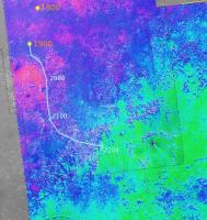
|
Posted by: ustrax Jun 1 2009, 08:21 AM
Here you have it Floyd, not as accurate as Tesheiner's but you get the idea...

|
Posted by: Floyd Jun 1 2009, 09:45 AM
Thanks Phil, James & ustrax---I have a much clearer "big picture".
Posted by: djellison Jun 1 2009, 09:58 AM
For the first time, ever, timescales have been put on a Map at UMSF without epic epic http://en.wikipedia.org/wiki/Optimism
Posted by: ustrax Jun 1 2009, 10:21 AM
James making predictions and you writing "Onwards"...I'm a virus!
Posted by: BrianL Jun 1 2009, 05:45 PM
I'll go out on a limb here and say, not only will the "Endeavour Exit Ramp" be where we definitely make the turn towards that non-shining beacon in the distance, but that this will be the next pit stop in this leg of the race.
Posted by: PaulM Jun 1 2009, 07:09 PM
I thought that the rim of Endeavour consisted of sulphate rich sandstones with a similar appearance to those found so far. They may have been excavated from much lower in the 1 km thick stack of sulphate rich sandstones but would look very similar to an untrained observer to those found so far.
I think that to reach the really interesting clays beneath these deposits the floor of Endeavour crater would have to be 500 metres deeper than it is.
I believe that the closest outcrop of these interesting clays is the MSL South Meridiani landing site which is 75 km south of Opportunity's current position and the MSL Miyamoto landing site which is 150 km South West of Opportunity's current position:
http://marsoweb.nas.nasa.gov/landingsites/msl2009/memoranda/sites_jul08/Wiseman_Arvidson_6_23_08.pdf
http://marsoweb.nas.nasa.gov/landingsites/msl2009/workshops/3rd_workshop/talks/Newsom_Miyamoto.pdf
I am not suggesting that Opportunity could drive for a further 75 km. However, these two papers make interesting reading because they place Opportunity in its regional context. Also Opportunity is currently heading directly for the South Meridiani landing site and so if a Rover Driver was to fall asleep at the wheel then Opportunity might end up at the South Meridiani landing site by accident
Posted by: Phil Stooke Jun 1 2009, 08:45 PM
I don't think Endeavour's rim will consist of the same rocks we've seen so far. The previous examples were in small craters excavated in those sandstones. My impression of Endeavour is that it's an old crater, part of the cratered terrain underlying Meridiani Planum. I think it's being exhumed by the removal of Meridiani Planum materials, but its rim materials will be very different.
Phil
Posted by: ElkGroveDan Jun 1 2009, 11:27 PM
I'm also anticipating the outside chance that the exhuming began before or during the presence of the Meridiani Seahttp://www.unmannedspaceflight.com/index.php?showtopic=5503&view=findpost&p=141313 and as the rover gains in elevation I'm hoping we will encounter distinct eroded shorelines. Would that be cool or what? I'm very intrigued by what we've seen in the HIRISE images and the apparent discontinuity at the base of the slopes.
(Yes I know it could just as easily be more ventifact topography.)
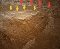
|
Posted by: dburt Jun 2 2009, 03:15 AM
Your "shorelines" could also be something else entirely, such as the outer limits of regolith creep or of ancient ground ice movement. Similar-appearing boundaries seem to be fairly common at or near distinct breaks in slope on Mars.
-- HDP Don
Posted by: CosmicRocker Jun 2 2009, 04:27 AM
That's what I would expect, too. As a matter of fact, Steve Squyres discussed this topic at some length in the May 22, 2009 http://www.sciencefriday.com/ interview. In short, he said Endeavor's rim rocks are completely different from the sulfate sands of Meridiani Planum, they look completely different spectrally, from orbit. He described the elevated rim as sticking up like an island, through the younger sediments.
In conclusion, to emphasize how different these rocks are, he noted that if Opportunity makes it to Endeavor's rim it will be like starting a completely new mission.
Posted by: ElkGroveDan Jun 2 2009, 04:54 AM
Yep they sure could be. They could be mud flows caused by excess rain on a slope where the vegetation was destroyed in last summer's wildfires. They could even be the perimeter of a massive melted ice cream sundae that re-hardened after it got cold one night. Everyone is entitled to their own wacky theory. However I wasn't using the image as evidence of anything. If you read my post again you will see that I used that image to describe my HOPE that shorelines would be encountered, and those are POSSIBLE locations where shorelines might be encountered.
Posted by: centsworth_II Jun 2 2009, 05:26 AM
Are you saying that "regolith creep" or "ancient ground ice movement" on Mars are about as likely as "mud flows caused by excess rain" or "a massive melted ice cream sundae"? Or are you saying that an ancient shoreline is about that likely. I can't tell if you are being dismissive of dburt's ideas or of your own.
Posted by: djellison Jun 2 2009, 07:27 AM
He's highlighting the fact that DB failed to actually read EGD's post and used it as an excuse to push his non-aqueous meridiani theory which already has its own thread.
Posted by: centsworth_II Jun 2 2009, 07:54 AM
I've never heard of "the Meridiani Sea". My impression is that the prevailing theory is that periodically surfacing groundwater is sufficient to explain Opportunity's observations.
Posted by: djellison Jun 2 2009, 08:05 AM
I think you are reading too much into throw away comments.
Posted by: Juramike Jun 2 2009, 11:37 AM
(Yes I know it could just as easily be more ventifact topography.)
What different observations from Opportunity would we expect to see if the "terrain break" resulted from:
a shoreline?
a ventrifact?
from regolith creep?
from ground ice movement
(Are there key observations that could easily eliminate one or more of these?)
[Time to put yer bets down, we'll be there before we know it!]
Posted by: PaulM Jun 2 2009, 11:57 AM
Phil
It seems reasonable that Endurance might be an old crater that once was completely buried in meridiani deposits and is now being slowly exhumed.
However, the question that I would like to ask is what the process was by which the meridiani sediments that once filled Endeavour to the brim were selectively removed from the centre of Endeavour crater leaving the deep hole that can be seen today.
Gale crater is an old crater that was once completely buried in sediments. However, in the case of Gale crater the sediments in the centre of the crater remain and it is the sediments outside the crater that have been selectively eroded:
http://marsoweb.nas.nasa.gov/landingsites/msl2009/memoranda/sites_jul08/GaleCrater_Edgett_etal_Jun08.pdf
EDIT: I supose that it is possible that Endeavour was never fully filled with Meridiani sediments and so there would be no need to provide an explanation of how they were later removed. However, what this does imply is that if the line around the ancient hills was a shoreline then at that time Endeavour crater would have been a 500m deep lake.
Posted by: ElkGroveDan Jun 2 2009, 02:27 PM
OK that was my own exaggerated term. Even a "Meridiani Acid Swamp" would show evidence of a shoreline if a standing body of water did exist there. We shall see.
(And yes, the wacky theory I referred to was one that was not mentioned here.)
Posted by: Phil Stooke Jun 2 2009, 04:14 PM
One big problem with the Meridiani Sea is that there's no big depression to hold it. The area is on a regional slope. Any sea would have gone down the plug'ole.
Phil
Posted by: glennwsmith Jun 2 2009, 06:16 PM
I'm with Elk Grove Dan. Nobody, and that includes Steve Squyres, has the definitive story on Meridiani, much less the rest of Mars. When I look at the layering -- and I'm sorry to use that term, but that's what's there -- I can't help but believe that it is the sediment resulting from seasonal processes in a shallow lake or sea. And if the area is sloped now, that doesn't mean it was always sloped -- ever heard of the Rockies? And if it was a shallow lake or sea, then there may well be remnants of a shoreline. So back off and let people have a little fun with this site -- it's getting WAY too prissy.
Posted by: imipak Jun 2 2009, 07:12 PM
Further research is indicated. And as luck would have it...
Posted by: JayB Jun 2 2009, 07:26 PM
"The objective for June remains the same: "Drive. Drive. Drive," said Squyres."
http://www.planetary.org/news/2009/0531_Mars_Exploration_Rovers_Update_Spirit.html
Posted by: MarkG Jun 2 2009, 08:10 PM
In trying to understand Meridiani and the Endeavor rim, I keep the following things in mind...
1) The profound ancientness of the Martian surface.
2) The significant variability of the Martian atmosphere. Perhaps a third of it freezes and sublimates yearly, plus secular orbital and axis changes indicate periods of different conditions over time, plus injections and depletions by volcanoes and large impacts, plus highly variable dust content further obscures the issue. The presence all over Mars of ventiform terrain features whose formation is beyond the transport capability of the current atmosphere underscores this.
3) Any surface water would likely be either ice or ice-covered most (if not all) of the time, even in ancient Mars. Ice-dominated or periglacial shorelines is what one is likely to see. For Meridiani, the interplay between surface ice and very concentrated brine underneath is important to consider.
So, with the above in mind, I follow the rovers and the orbiters, and try to see how various ideas fit with the unfolding observations.
One of the things I keep thinking about it the "planed-carved-like" slopes in Victoria crater. The surface around the rim was either flat, a planed-down slope of 15-35 degrees, a cliff, or debris beneath a cliff. If the surface was covered by ice sheets that were seasonally mobilized by brine at their base, these ice sheets (or their large cracked pieces) would creep down slopes and effectively plane them.
Did this ice come from seepage from below or from precipitation from the atmosphere? Was Meridiani always equatorial? Fun questions.
Seeing the rim deposits of Endeavor may shed some light on this. Or pose more questions.
Posted by: ngunn Jun 2 2009, 08:35 PM
I have no idea whether or not this is relevant to Meridiani but one thing does connect the two posts quoted. Subglacial lakes do not need to be in topographic depressions - a slope will do just fine if the overlying pressure distribution is right. The plug'ole may be iced up! Subglacial hydrology and landforms are never far from my thoughts when looking at Mars.
Posted by: Phil Stooke Jun 2 2009, 08:47 PM
Ngunn's point is really good - and I don't see this getting prissy! - subglacial lakes might be allowed. So might regional crustal tilting, though it's a bit ad hoc. Personaly I prefer it all to be ground water, which might possibly make it to the surface in local low spots, either as concentrated brines which could remain liquid, or under an ice cover. I just don't see much chance of any big seas in this area.
Phil
Posted by: MahFL Jun 3 2009, 01:18 PM
Phil
We had subtropical jungle in the arctic circle on Earth, so anything is possible, given time.
Posted by: tty Jun 3 2009, 08:24 PM
Even a little better than that. During the early Eocene (c. 50 million years ago) there were alligators on Ellesmere Island (about 79 degrees north, and about the same then). This suggests that arctic temperatures were a bit over 30 degrees warmer than at present. Oddly enough equatorial temperatures were only slightly warmer than now.
Posted by: Phil Stooke Jun 3 2009, 09:06 PM
"there were alligators on Ellesmere Island"
Now they have to wear Tuques, even in summer.
"anything is possible"
I'm afraid that really isn't true, and many things that are possible also didn't actually happen.
Phil
Posted by: ElkGroveDan Jun 3 2009, 11:22 PM
My fault for bringing the term "sea" into this discussion.
Now let's get back on topic please.
Posted by: centsworth_II Jun 3 2009, 11:45 PM
I'm a little (
) confused.Does everyone agree that the layers of Meridiani Planum extend 800 or so meters beneath the surface that Opportunity now sits on? (I'm not saying that all those layers are of the same composition.) If so, that would mean that if Endeavour predates those layers, the visible peaks of it's rim would have been a kilometer or so high when first formed. Does that sound right?
Posted by: serpens Jun 4 2009, 06:38 AM
If we accept that the hematite signature is indicative of then upper layers of the sedimentary deposits then Endeavour certainly predates those deposits. Only the remnant rims do not have a hematite signature. In contrast the crater to the SW has an ejecta blanket covering the deposits which means it postdates the sedimentary deposition. Or maybe had an ejecta blanket high enough to preclude any groundwater near the surface. Or was fitted with some form of surge resistance. (Ok moderator I smack my own hand). The exciting thing is that the rim remnants of endeavour are old and would represent the basal layer beneath the sandstone . They would be great to investigate up close. I wonder if Oppy has Spirits mountain climbing genes?
Posted by: CosmicRocker Jun 5 2009, 05:02 AM
800 meters has been quoted as the thickness of the Meridiani Planum sediments in some papers I've read. I don't recall if that was an average thickness or a maximum, but regardless, the thickness is almost certainly not constant. One would expect the thickness of a package of sediments laid down on the eroded surface of some basement rock to be quite variable. The thickness would be great over deep basins, but thinner over basement highs. The rim of Endeavor is a very significantly uplifted region of basement rock, so I would expect the sediments to thin greatly toward the rim. To answer your question more directly, I would guess that the visible peaks were uplifted at least a kilometer above the average height of the surface the Meridiani sediments were deposited on.
Posted by: AndyG Jun 5 2009, 08:05 AM
http://mars.jpl.nasa.gov/mgs/sci/fifthconf99/6163.pdf would suggest a total crater depth of just over a kilometre for a crater 22km in diameter.
How high above the Meridiani surface are the rim peaks, out of interest? (I can't find a handy figure).
Andy
Posted by: tim53 Jun 5 2009, 02:18 PM
A Meridiani Sea is only possible if:
a: One invokes a former topographic barrier that is now gone
b: ...a subsequent regional tilt of the terrain (on a grand scale, since the deposits are vast)
c: dare I say it: An ocean in the northern plains that puddles up to this elevation.
The "bathtub ring" feature around the rim mountain in Endeavour that was shown above is interesting. When I first saw it, I got all excited, because it STRONGLY resembles shorelines in the Lake Bonneville basin.
...but all it took was HiRISE stereo to convince me that that's not what this feature is. It's not level OR planar. It appears to follow the gently rolling topography of the sulfate deposits overlying Endeavour, so it's more likely it's a remnant of one of these layers that has been preserved at the base of the mountain for some unknown reason while the rest has been eroded away. It'll be interesting to see what it looks like on the ground.
As always, the Real Mars turns out to be more complicated/interesting than our first impressions would suggest!
-Tim.
Posted by: ElkGroveDan Jun 5 2009, 04:21 PM
Thanks Tim. Now I don't feel foolish any more. The old geologist in me can now raise his chin a little higher again.
Posted by: tim53 Jun 5 2009, 04:30 PM
Absolutely! This is the great thing about geology. Especially now, with Mars. Unlike the 20 years post-Viking, when we would hypothesize and not have a chance to shoot holes in each others' hypotheses with much substance, now we can send a rover over to check it out!
-Tim
Posted by: CosmicRocker Jun 6 2009, 06:30 AM
I don't know of any published values for that, but if you bring up Mars in Google Earth 5 and go to Endeavour Crater, you can browse surface elevations by watching the XYZ readout at the bottom of the screen as you move your cursor over the map. I'm not certain, but I assume these are MOLA derived elevations. Doing so, I roughly estimate the rim peaks to range up to ~100 meters above the regional surface. The deepest part of the excavated crater basin is ~ -500 meters.
Posted by: Fran Ontanaya Jun 6 2009, 01:28 PM
The HRSCview map of Endeavour was posted around here before: http://hrscview.fu-berlin.de/cgi-bin/ion-p?ION__E1=UPDATE%3Aion%3A%2F%2Fhrscview.ion&image=3220_0001&image1=4+images&lat=-2.268&lon=354.827&zoom=2&mode=nd%2Bdtm&scale=38&persp=on&pview=East&exag=8&viewport=1150x680&UPDATE=Update+view&image0=3220_0001&code=67381539
Posted by: fredk Jun 6 2009, 04:05 PM
The geometer in me shouts, "I can measure their height myself!" Or at least put a lower limit on their height.
All three bits we see now appear similar angular heights, but the east rim is farthest away so that's the greatest vertical extent of the rim that we can see now. Using http://marsrovers.jpl.nasa.gov/gallery/all/1/p/1822/1P289931751EFF9993P2422R1M1.JPG of the east rim, and a distance of about 33.5 km, I get a height of about 85 metres for the part we can see. Of course we're likely not seeing the full extent of this bit yet, so that number will only climb as we approach...
Posted by: helvick Jun 6 2009, 04:53 PM
If the far rim is 33.5 km distant and that is what we are looking at then another 160m or so is below the horizon at the moment.
Posted by: tty Jun 6 2009, 06:34 PM
...but all it took was HiRISE stereo to convince me that that's not what this feature is. It's not level OR planar. It appears to follow the gently rolling topography of the sulfate deposits overlying Endeavour
That is not a very strong argument against it being an old shoreline. Old shorelines are often deformed by subsequent earth movements. Even the shorelines of Lake Bonneville that you mention are about 150 feet higher in the central part of the basin compared to the edges because of isostatic rebound after the lake disappeared, though this is not obvious because the change is very gradual.
In a more seismically active area like Italy the level of the shoreline from the prevous interglacial (just 125,000 years ago) varies from +170 to -130 meters.
Posted by: Enceladus75 Jun 6 2009, 06:37 PM
I thought a few months ago people here were giving estimates of up to a 1,000 metres or more for the far rim of Endeavour.
But now these estimates have hugely dropped. So the rim of Endeavour is now only expected to be 100 metres above Meridiani? That's a tad disappointing... 
Posted by: stevesliva Jun 6 2009, 06:45 PM
We are waiting for the next big one here withing the shores of Lake Bonneville. Something like 1 in 500 chance of a 7.0 any given year. I'm in a 105 year old masonry house right near the fault... so let's hope you're right.
I have been wondering how much isostatic rebound might affect Mars... but does there need to be a mantle underneath?
Posted by: ElkGroveDan Jun 6 2009, 07:12 PM
Here's an image of Antelope Island with wave cut platforms in (the former) Lake Bonneville. I bet Stu could give it that Meridiani look, and maybe that's what we'll see when we get to the rim of Endeavor.
EDIT: Never mind Stu. I took a whack at it. Maybe Endeavor will look like this.
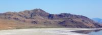
|

|
Posted by: glennwsmith Jun 6 2009, 07:37 PM
ElkGroveDan, that's a very neat picture -- it doesn't take too much imagining to connect it with Meridiani!
And here's something hot off the press from the Imperial College of London which supports the possibility of large bodies of water -- whether you want to call them lakes, seas, or oceans -- having once existed on Mars. The link is as follows:
http://www3.imperial.ac.uk/newsandeventspggrp/imperialcollege/newssummary/news_1-6-2009-10-59-30#fni-2
Their thesis is that the Late Heavy Bombardment added huge quantities of water to the surfaces of both Earth and Mars. I quote briefly:
"They found that on average, each meteorite was capable of releasing up to 12 percent of its mass as water vapour and 6 percent of its mass as carbon dioxide when entering an atmosphere . . .Using published models of meteoritic impact rates during the LHB, the researchers calculated that 10 billion tonnes of carbon dioxide and 10 billion tonnes of water vapour could have been delivered to the atmospheres of Earth and Mars each year . . . However, researchers say Mars good fortune did not last. Unlike Earth, Mars doesnt have a magnetic field to act as a protective shield from the Suns solar wind. As a consequence, Mars was stripped of most of its atmosphere. A reduction in volcanic activity also cooled the planet. This caused its liquid oceans to retreat to the poles where they became ice."
Posted by: glennwsmith Jun 6 2009, 08:44 PM
And tim53, re your "ocean in the northern plains that puddles up to this elevation", take a look at the thread "Earthlike Mars?" (in the general Mars area), which is really about the Oceanus Borealis. (And which thread now seems to be connected, thanks to tim, to the entire subject of Meridiani!)
Posted by: CosmicRocker Jun 7 2009, 06:59 AM
I'm curious about the sample spacing in the MOLA data. Hopefully, someone more knowledgeable of the dataset will comment. I am trying to understand if the narrow rims of craters like Endeavour might be under-sampled in the MOLA dataset.
It appears that the MOLA elevation models were derived from measurements made on areal spacings of up to 1/128th degree. At the Martian equator, 1/128th degree = ~463 meters. I found a reference suggesting that some MOLA data might be sampled up to 1/256th of a degree, yielding twice the resolution, or ~232 meters/pixel.
Considering that Endeavour's rim ridges are roughly a hundred to several hundred meters across, it seems unlikely that MOLA was able to capture many measurements at the highest peaks around the rim. If that is the case, the MOLA elevation model might under-represent the highest elevations of narrow ridges such as crater rims. I can imagine that fancy interpolation algorithms can partially compensate for under-sampling, but I wonder just how confident we can be with regard to the MOLA-modeled elevations.
Posted by: dvandorn Jun 7 2009, 02:18 PM
The numbers you mention just describe the "resolution" between sample strips, Tom. There is also the question of resolution along the strip -- i.e., what was the interval between laser returns?
Also, "resolution" isn't exactly the right term, I think -- the *spacing* between sample strips is anywhere from 1/128 to 1/256 of a degree. The actual width of the strip of terrain from which a laser return is detected is somewhat narrower than that, I believe. So, instead of having a constant "pixel" coverage of laser returns, there is a matrix of laser-return dots which represent terrain elevation data, but for which no single dot "touches" any of its adjacent dots. In other words, there are from tens to several hundreds of meters of terrain between each sampled "pixel" and the next closest "pixel."
Think of it this way -- go to a plot of land 25 km on a side, lay out ten lines 250 meters apart and 25 km long. Walk along each of those lines and take an elevation reading every 100 meters or so. Then plot all of your elevation readings as a series of dots on a grid. That's the raw MOLA data. (Totally unsure about the spacing along the lines, but ~100 meters sounds about right, at least for illustration purposes.) Add in beam spread, and you can see how difficult it was to create elevation maps from the data.
I believe the pretty maps that the MOLA team created *all* used smoothing algorithms to present the instrument's data as general elevation maps.
-the other Doug
Posted by: helvick Jun 7 2009, 04:03 PM
As Doug said it's hard to make any sort of generalizations with the MOLA data - you have to look up the individual strips and see what they covered specifically in order to decide if the processed data set might have missed any significant peaks or dips in any specific area. Over the whole planet the total mission sampling averaged about 6 points per square km but if a particular sample strip crossed a point of interest there could well be more points than that - the nominal "resolution" of each track was one sample every 300m and each sample covered an on track distance of 120m. In very rugged terrain (such as Endeavor's rim) it would certainly be possible for MOLA to have measured altitudes that are in the range of 100m lower than the actual maximum altitude of the peaks, possibly even more. To be more certain you'd have to find the specific MOLA tracks and see what they actually did cover.
The spec's on http://starbrite.jpl.nasa.gov/pds/viewInstrumentProfile.jsp?INSTRUMENT_ID=MOLA&INSTRUMENT_HOST_ID=MGS.
Posted by: CosmicRocker Jun 8 2009, 04:13 AM
Thanks guys, for your comments. I see how the actual location of the track on the ground is critical. You've confirmed my thoughts, though, that the data spacing is large enough that many, or even most peaks on the crater rim would have been undetected by the sampling. That PDS instrument profile for the laser altimeter was very enlightening. It had this to say about mapping resolution:
Since all the orbits cross at the poles it is easy to see how the sampling density increases towards the poles. Since Endeavour is near the equator, the sample density there is likely to be lower.
Posted by: tty Jun 8 2009, 07:44 PM
I hope so. There is at least four old beach levels in that picture, and possibly a fifth.
Posted by: Reed Jun 8 2009, 09:18 PM
Regarding DTMs, don't forget there's Mars HRSC coverage of this area too.
http://hrscview.fu-berlin.de/cgi-bin/ion-p?ION__E1=UPDATE%3Aion%3A%2F%2Fhrscview.ion&image=2064_0000&image1=4+images&lat=-2.262&lon=354.536&zoom=2&mode=dtm&scale=50&pview=North&exag=1&viewport=1150x680&UPDATE=Update+view&image0=2064_0000&code=52692150
Posted by: SFJCody Jun 22 2009, 08:54 PM
This may have been asked before, but does anyone know whether MARSIS or SHARAD might be capable of mapping the contact between the Meridiani sandstones and the underlying basement rock?
Posted by: glennwsmith Jun 23 2009, 02:32 AM
Speaking of shorelines, I'm sure most of you know that there is yet another recent paper indicating the presence of lakes on Mars. Here's the link:
http://www.colorado.edu/news/r/7e9c22ec0cd6dabc007bb14ed2e29f16.html
Posted by: tim53 Jun 23 2009, 10:10 PM
http://www.colorado.edu/news/r/7e9c22ec0cd6dabc007bb14ed2e29f16.html
It's a fault scarp. (see my post in "Earthlike Mars")
-Tim.
Posted by: SFJCody Jun 27 2009, 09:27 PM
For fans of Iazu crater here's a Google Earth overlay of moc frame m1001349.  Iazu_Crater__MOC_Image_m1001349_.kml ( 646bytes )
: 523
Iazu_Crater__MOC_Image_m1001349_.kml ( 646bytes )
: 523
It's not sourced from a map projected version of the image so the registration isn't as great as it could be but when crudely draped over topography data it does give an OK overview of the differences between the older, shallower Endeavour and the younger pedestal crater to the south. Check out that deep stack of sediments at Iazu's north rim!
Why not use a proper map projected version of the image? Because then I'd either have to put up with a conspicuous frame or set the frame to be transparent. Doing the latter would require altering the image file, so I would no longer be able to link to an image already available online!
Posted by: Bill Jun 28 2009, 08:19 AM
I think we can barely see a new part of Endeavour in these navcams just on the left of "Cook":
http://qt.exploratorium.edu/mars/opportunity/navcam/2009-06-27/1N298896772EFFA3G6P1994L0M1.JPG
http://qt.exploratorium.edu/mars/opportunity/navcam/2009-06-27/1N299256167EFFA3NVP1994L0M1.JPG
Waiting for pancams.
I think a peak north of "Cook" could match (far rim or east rim) . Any idea Rui or James ?
Posted by: RoverDriver Jun 28 2009, 01:39 PM
...
P1994 is a single frame, single eye navcam frame I asked to take at the end of each drive since we left Duck Bay. Every drive sol in the same direction, roughly pointed at Endeavour.
Paolo
Posted by: jamescanvin Jun 28 2009, 02:53 PM
or east rim) . Any idea Rui or James ?I think you are right, there does appear to be a faint hint of a feature 6 - 8 degrees from the north end of Cook. Measuring the angles I think it correlates to this on the HRSC image:
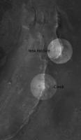
|
In Google Earth this does look to be the next highest feature on the east rim after Cook.
James
Posted by: Tesheiner Jun 28 2009, 09:21 PM
Paolo
Got it! Now I understand the "MovieFrame" in the sequence name.
Anyone wants to have a try building the movie up to date?
Posted by: fredk Jun 29 2009, 02:33 AM
I've been collecting these L0 navcam frames and was meaning to ask about them. Do they serve a purpose such as photometry/sky imaging/characterizing the terrain under uniform lighting/etc, or are they just providing a regular view of the approaching rim of endeavour?
Btw, the R0 navcam jpeg frames from the jpl site are always cleaner than the L0 frames. This R0 frame shows a similar view to those two L0 frames:
http://marsrovers.jpl.nasa.gov/gallery/all/1/n/1920/1N298633489EFFA3EZP0705R0M1.JPG
I think there is a very subtle feature there.
Posted by: RoverDriver Jun 29 2009, 03:03 AM
Do they serve a purpose such as photometry/sky imaging/characterizing the terrain under uniform lighting/etc, or are they just providing a regular view of the approaching rim of endeavour?
...
Nope, their sole goal is to document the approach to Endeavour. I'm sure someone can make scientific use of it, but the idea was just that, documentation of the approach.
Paolo
Posted by: MahFL Jun 29 2009, 02:06 PM
A very good idea Paolo. At what horizontal distance from the highest rim will the frame be filled from top to bottem on the Navcams ?
Posted by: ustrax Jun 30 2009, 11:21 AM
James...everyone knows that's Molyneaux...
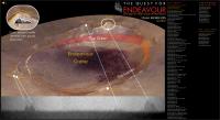
|
Posted by: jamescanvin Jun 30 2009, 12:17 PM
Heck, I can't keep up - here was me thinking it was Hicks...
http://www.unmannedspaceflight.com/index.php?s=&showtopic=5702&view=findpost&p=137625
James
Posted by: ustrax Jun 30 2009, 01:04 PM
Hicks is where Cook tells him to be...
Powered by Invision Power Board (http://www.invisionboard.com)
© Invision Power Services (http://www.invisionpower.com)