Rev 206 and T103 |

  |
Rev 206 and T103 |
 Jul 8 2014, 03:47 AM Jul 8 2014, 03:47 AM
Post
#1
|
||
|
Member  Group: Members Posts: 699 Joined: 1-April 08 From: Minnesota ! Member No.: 4081 |
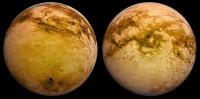
Rev 206 and T103 http://www.ciclops.org/view/7901/Rev206?js=1
T103 is another approach to the southern sub-Saturn hemisphere. An interesting area visible in the approaching T103 images is the region of Chusuk Planitia http://planetarynames.wr.usgs.gov/Feature/...AFF85346635F19C This area was imaged by VIMS in one of its highest resolution views of Titan’s surface (500m/pixel). An important paper in Icarus by Jaumann et al http://www.barnesos.net/publications/paper...on.on.Titan.pdf analyzed the VIMS spectral properties of the star shaped Bohai Sinus and adjacent Chusuk Planitia regions concluding that fluvial mechanisms and particle size/composition were responsible for the complex but systematic spectral changes noted. This paper was discussed before in this forum http://www.unmannedspaceflight.com/index.php?showtopic=4724 although not all had access to all figures and text. Since its publication there have been two equatorial storms (April 2008 http://www.unmannedspaceflight.com/index.p...c=6146&st=0 and Sept 2010 http://www.unmannedspaceflight.com/index.p...t&p=164604) and a SAR topo map http://web.mit.edu/perron/www/files/Aharonson13.pdf that lend support to the paper’s conclusion. The Chusuk Planitia region is under consideration for future missions to Titan 's surface. http://solarsystem.nasa.gov/docs/pr344.pdf
EDIT: a new link to a more readable version of the Jaumann paper has now been inserted above. |
|
 |
 
|
|
|
Jul 19 2014, 07:37 PM
Post
#2
|
|
|
Member Group: Members Posts: 699 Joined: 1-April 08 From: Minnesota ! Member No.: 4081 |
The T103 flyby 'Mission Overview' http://saturn.jpl.nasa.gov/mission/flybys/titan20140720/ is now up on the Cassini website.
|
|
|
|
|
Jul 23 2014, 12:21 PM
Post
#3
|
||
|
Member Group: Members Posts: 699 Joined: 1-April 08 From: Minnesota ! Member No.: 4081 |
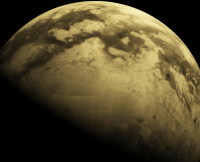
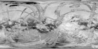
Many NAC and WAC raw images from the T103 flyby have come down. 6 of the 8 inbound global mapping ISS images are roughly placed on the Looking Ahead Titan image below.
|
|
|
|
|
|
|
Jul 27 2014, 06:25 AM
Post
#4
|
||
|
Member Group: Members Posts: 699 Joined: 1-April 08 From: Minnesota ! Member No.: 4081 |
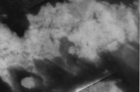
T 103 ISS images of Titans north polar region taken on 7-21-2014 reveal Kraken mares full extent. The figure below combines N00226702 and N00226698 and the figure from Rev 206 Looking Ahead and is enhanced to show the north polar seas.
|
|
|
|
|
|
|
Jul 27 2014, 03:32 PM
Post
#5
|
|
 Senior Member Group: Members Posts: 1629 Joined: 5-March 05 From: Boulder, CO Member No.: 184 |
Just curious how the basemaps are doing nowadays. The looking ahead depiction looks nice for the north polar region. What global image mosaic was used for the looking ahead (if it is available)?
-------------------- Steve [ my home page and planetary maps page ]
|
|
|
|
|
Jul 30 2014, 03:54 AM
Post
#6
|
|
|
Member Group: Members Posts: 699 Joined: 1-April 08 From: Minnesota ! Member No.: 4081 |
Not certain where or if the Titan map files that are used in Looking Ahead are available. The Celestia Program 1.6.1 (I think thats still the latest version available) is used to create the images for Looking Ahead but the graphic map for Titan is not the one that is available with that program. My presumption is that Jason Perry (Volcanopele or VP) updates a custom map of Titan from calibrated and carefully processed ISS images and uses that in the Celestia program to produce the Looking Ahead graphics. Perhaps VP or John VV http://www.unmannedspaceflight.com/index.p...st&p=209464 can comment on this.
|
|
|
|
|
Jul 31 2014, 07:04 PM
Post
#7
|
|
|
Member Group: Members Posts: 890 Joined: 18-November 08 Member No.: 4489 |
I do need to update my map
it also is not 100% scientifically accurate i remove seems and clean up the image I guess i could take a break from the 65535x32768 mercury map as i recall the cyclops map is the JPL one http://www.ciclops.org/view/6924/Map-of-Titan---April-2011 or the one colored by : Dr. Fridger Schrempp http://www.celestialmatters.org/?q=node/56 also the default titan texture in the SVN 5229 ( basically 1.7.0 ) CODE svn checkout svn://svn.code.sf.net/p/celestia/code/ celestia-code is the old 2006 map |
|
|
|
|
Aug 2 2014, 09:14 AM
Post
#8
|
||
 Member Group: Members Posts: 106 Joined: 26-September 05 Member No.: 508 |
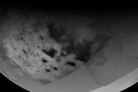
Here is a cosmetically fixed version of the Ciclops map, if someone wishes to add the new images.
Attached thumbnail(s)
|
|
|
|
|
|
|
Aug 2 2014, 11:13 AM
Post
#9
|
||
|
Member Group: Members Posts: 106 Joined: 26-September 05 Member No.: 508 |
Couple of renders.
Attached thumbnail(s)
|
|
|
|
|
|
|
Aug 3 2014, 01:22 AM
Post
#10
|
|
|
Member Group: Members Posts: 699 Joined: 1-April 08 From: Minnesota ! Member No.: 4081 |
Terrific render T_oner !!! Can one load that into Celestia and use it with the program?
|
|
|
|
|
Aug 3 2014, 02:47 AM
Post
#11
|
|
|
Member Group: Members Posts: 890 Joined: 18-November 08 Member No.: 4489 |
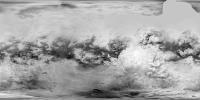
here is a "cleaned up" 4096 x 2048 ( -180 to 180 ) sepia toned map
the CYCLOPS 2011 map https://drive.google.com/file/d/0B6ZYAd08tZ...dit?usp=sharing some of the missing area in the north was added from the radar data a 1024x512 preview  for those that do not know already The program Celestia uses images that have zero longitude in the center CODE +90 north -180 W to 0 to +180 E -90 south and there is a tutorial for using "SPICE" for the orbits and spacecraft trajectories http://forum.celestialmatters.org/viewforum.php?f=18 that whole section is on using the NAIF SPICE kernels |
|
|
|
|
Aug 3 2014, 10:43 AM
Post
#12
|
||
|
Member Group: Members Posts: 106 Joined: 26-September 05 Member No.: 508 |
Thanks for the map John, (wish you had released it a day earlier which would have saved me 2 hours fixing the cosmetic defects
 ). ).Here is another version with the SAR data, I plan to add the Hisar images.
Attached thumbnail(s)
|
|
|
|
|
|
|

|
Lo-Fi Version | Time is now: 28th April 2024 - 03:40 AM |
|
RULES AND GUIDELINES Please read the Forum Rules and Guidelines before posting. IMAGE COPYRIGHT |
OPINIONS AND MODERATION Opinions expressed on UnmannedSpaceflight.com are those of the individual posters and do not necessarily reflect the opinions of UnmannedSpaceflight.com or The Planetary Society. The all-volunteer UnmannedSpaceflight.com moderation team is wholly independent of The Planetary Society. The Planetary Society has no influence over decisions made by the UnmannedSpaceflight.com moderators. |
SUPPORT THE FORUM Unmannedspaceflight.com is funded by the Planetary Society. Please consider supporting our work and many other projects by donating to the Society or becoming a member. |
|