Endeavour Crater, And again shall we conquer the Remoteness |

  |
Endeavour Crater, And again shall we conquer the Remoteness |
 Jun 6 2009, 06:30 AM Jun 6 2009, 06:30 AM
Post
#271
|
|
 Senior Member  Group: Members Posts: 2228 Joined: 1-December 04 From: Marble Falls, Texas, USA Member No.: 116 |
QUOTE (AndyG @ Jun 5 2009, 03:05 AM)  ... How high above the Meridiani surface are the rim peaks, out of interest? (I can't find a handy figure). ... I don't know of any published values for that, but if you bring up Mars in Google Earth 5 and go to Endeavour Crater, you can browse surface elevations by watching the XYZ readout at the bottom of the screen as you move your cursor over the map. I'm not certain, but I assume these are MOLA derived elevations. Doing so, I roughly estimate the rim peaks to range up to ~100 meters above the regional surface. The deepest part of the excavated crater basin is ~ -500 meters. -------------------- ...Tom
I'm not a Space Fan, I'm a Space Exploration Enthusiast. |
 |
 
|
|
Jun 6 2009, 01:28 PM
Post
#272
|
|
|
Member Group: Members Posts: 293 Joined: 22-September 08 From: Spain Member No.: 4350 |
The HRSCview map of Endeavour was posted around here before: link
|
|
|
|
|
Jun 6 2009, 04:05 PM
Post
#273
|
|
 Senior Member Group: Members Posts: 4246 Joined: 17-January 05 Member No.: 152 |
QUOTE (AndyG @ Jun 5 2009, 09:05 AM) How high above the Meridiani surface are the rim peaks, out of interest? The geometer in me shouts, "I can measure their height myself!" Or at least put a lower limit on their height. All three bits we see now appear similar angular heights, but the east rim is farthest away so that's the greatest vertical extent of the rim that we can see now. Using this image of the east rim, and a distance of about 33.5 km, I get a height of about 85 metres for the part we can see. Of course we're likely not seeing the full extent of this bit yet, so that number will only climb as we approach... |
|
|
|
|
Jun 6 2009, 04:53 PM
Post
#274
|
|
 Dublin Correspondent Group: Admin Posts: 1799 Joined: 28-March 05 From: Celbridge, Ireland Member No.: 220 |
If the far rim is 33.5 km distant and that is what we are looking at then another 160m or so is below the horizon at the moment.
|
|
|
|
|
Jun 6 2009, 06:34 PM
Post
#275
|
|
|
Member Group: Members Posts: 688 Joined: 20-April 05 From: Sweden Member No.: 273 |
QUOTE (tim53 @ Jun 5 2009, 04:18 PM) The "bathtub ring" feature around the rim mountain in Endeavour that was shown above is interesting. When I first saw it, I got all excited, because it STRONGLY resembles shorelines in the Lake Bonneville basin. ...but all it took was HiRISE stereo to convince me that that's not what this feature is. It's not level OR planar. It appears to follow the gently rolling topography of the sulfate deposits overlying Endeavour That is not a very strong argument against it being an old shoreline. Old shorelines are often deformed by subsequent earth movements. Even the shorelines of Lake Bonneville that you mention are about 150 feet higher in the central part of the basin compared to the edges because of isostatic rebound after the lake disappeared, though this is not obvious because the change is very gradual. In a more seismically active area like Italy the level of the shoreline from the prevous interglacial (just 125,000 years ago) varies from +170 to -130 meters. |
|
|
|
| Guest_Enceladus75_* |
Jun 6 2009, 06:37 PM
Post
#276
|
|
Guests |
I thought a few months ago people here were giving estimates of up to a 1,000 metres or more for the far rim of Endeavour.
But now these estimates have hugely dropped. So the rim of Endeavour is now only expected to be 100 metres above Meridiani? That's a tad disappointing... 
|
|
|
|
|
Jun 6 2009, 06:45 PM
Post
#277
|
|
|
Senior Member Group: Members Posts: 1582 Joined: 14-October 05 From: Vermont Member No.: 530 |
QUOTE (tty @ Jun 6 2009, 02:34 PM) In a more seismically active area like Italy the level of the shoreline from the prevous interglacial (just 125,000 years ago) varies from +170 to -130 meters. We are waiting for the next big one here withing the shores of Lake Bonneville. Something like 1 in 500 chance of a 7.0 any given year. I'm in a 105 year old masonry house right near the fault... so let's hope you're right. I have been wondering how much isostatic rebound might affect Mars... but does there need to be a mantle underneath? |
|
|
|
|
Jun 6 2009, 07:12 PM
Post
#278
|
|||
 Senior Member Group: Admin Posts: 4763 Joined: 15-March 05 From: Glendale, AZ Member No.: 197 |
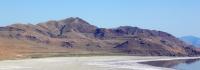
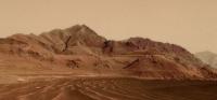
Here's an image of Antelope Island with wave cut platforms in (the former) Lake Bonneville. I bet Stu could give it that Meridiani look, and maybe that's what we'll see when we get to the rim of Endeavor.
EDIT: Never mind Stu. I took a whack at it. Maybe Endeavor will look like this.
Attached thumbnail(s)
-------------------- If Occam had heard my theory, things would be very different now.
|
||
|
|
|
||
|
Jun 6 2009, 07:37 PM
Post
#279
|
|
|
Member Group: Members Posts: 233 Joined: 21-April 05 Member No.: 328 |
ElkGroveDan, that's a very neat picture -- it doesn't take too much imagining to connect it with Meridiani!
And here's something hot off the press from the Imperial College of London which supports the possibility of large bodies of water -- whether you want to call them lakes, seas, or oceans -- having once existed on Mars. The link is as follows: http://www3.imperial.ac.uk/newsandeventspg...-10-59-30#fni-2 Their thesis is that the Late Heavy Bombardment added huge quantities of water to the surfaces of both Earth and Mars. I quote briefly: "They found that on average, each meteorite was capable of releasing up to 12 percent of its mass as water vapour and 6 percent of its mass as carbon dioxide when entering an atmosphere . . .Using published models of meteoritic impact rates during the LHB, the researchers calculated that 10 billion tonnes of carbon dioxide and 10 billion tonnes of water vapour could have been delivered to the atmospheres of Earth and Mars each year . . . However, researchers say Mars good fortune did not last. Unlike Earth, Mars doesnt have a magnetic field to act as a protective shield from the Suns solar wind. As a consequence, Mars was stripped of most of its atmosphere. A reduction in volcanic activity also cooled the planet. This caused its liquid oceans to retreat to the poles where they became ice." |
|
|
|
|
Jun 6 2009, 08:44 PM
Post
#280
|
|
|
Member Group: Members Posts: 233 Joined: 21-April 05 Member No.: 328 |
And tim53, re your "ocean in the northern plains that puddles up to this elevation", take a look at the thread "Earthlike Mars?" (in the general Mars area), which is really about the Oceanus Borealis. (And which thread now seems to be connected, thanks to tim, to the entire subject of Meridiani!)
|
|
|
|
|
Jun 7 2009, 06:59 AM
Post
#281
|
|
|
Senior Member Group: Members Posts: 2228 Joined: 1-December 04 From: Marble Falls, Texas, USA Member No.: 116 |
I'm curious about the sample spacing in the MOLA data. Hopefully, someone more knowledgeable of the dataset will comment. I am trying to understand if the narrow rims of craters like Endeavour might be under-sampled in the MOLA dataset.
It appears that the MOLA elevation models were derived from measurements made on areal spacings of up to 1/128th degree. At the Martian equator, 1/128th degree = ~463 meters. I found a reference suggesting that some MOLA data might be sampled up to 1/256th of a degree, yielding twice the resolution, or ~232 meters/pixel. Considering that Endeavour's rim ridges are roughly a hundred to several hundred meters across, it seems unlikely that MOLA was able to capture many measurements at the highest peaks around the rim. If that is the case, the MOLA elevation model might under-represent the highest elevations of narrow ridges such as crater rims. I can imagine that fancy interpolation algorithms can partially compensate for under-sampling, but I wonder just how confident we can be with regard to the MOLA-modeled elevations. 
-------------------- ...Tom
I'm not a Space Fan, I'm a Space Exploration Enthusiast. |
|
|
|
|
Jun 7 2009, 02:18 PM
Post
#282
|
|
 Senior Member Group: Members Posts: 3419 Joined: 9-February 04 From: Minneapolis, MN, USA Member No.: 15 |
The numbers you mention just describe the "resolution" between sample strips, Tom. There is also the question of resolution along the strip -- i.e., what was the interval between laser returns?
Also, "resolution" isn't exactly the right term, I think -- the *spacing* between sample strips is anywhere from 1/128 to 1/256 of a degree. The actual width of the strip of terrain from which a laser return is detected is somewhat narrower than that, I believe. So, instead of having a constant "pixel" coverage of laser returns, there is a matrix of laser-return dots which represent terrain elevation data, but for which no single dot "touches" any of its adjacent dots. In other words, there are from tens to several hundreds of meters of terrain between each sampled "pixel" and the next closest "pixel." Think of it this way -- go to a plot of land 25 km on a side, lay out ten lines 250 meters apart and 25 km long. Walk along each of those lines and take an elevation reading every 100 meters or so. Then plot all of your elevation readings as a series of dots on a grid. That's the raw MOLA data. (Totally unsure about the spacing along the lines, but ~100 meters sounds about right, at least for illustration purposes.) Add in beam spread, and you can see how difficult it was to create elevation maps from the data. I believe the pretty maps that the MOLA team created *all* used smoothing algorithms to present the instrument's data as general elevation maps. -the other Doug -------------------- The trouble ain't that there is too many fools, but that the lightning ain't distributed right. -Mark Twain
|
|
|
|
|
Jun 7 2009, 04:03 PM
Post
#283
|
|
|
Dublin Correspondent Group: Admin Posts: 1799 Joined: 28-March 05 From: Celbridge, Ireland Member No.: 220 |
As Doug said it's hard to make any sort of generalizations with the MOLA data - you have to look up the individual strips and see what they covered specifically in order to decide if the processed data set might have missed any significant peaks or dips in any specific area. Over the whole planet the total mission sampling averaged about 6 points per square km but if a particular sample strip crossed a point of interest there could well be more points than that - the nominal "resolution" of each track was one sample every 300m and each sample covered an on track distance of 120m. In very rugged terrain (such as Endeavor's rim) it would certainly be possible for MOLA to have measured altitudes that are in the range of 100m lower than the actual maximum altitude of the peaks, possibly even more. To be more certain you'd have to find the specific MOLA tracks and see what they actually did cover.
The spec's on MOLA are available here. |
|
|
|
|
Jun 8 2009, 04:13 AM
Post
#284
|
|
|
Senior Member Group: Members Posts: 2228 Joined: 1-December 04 From: Marble Falls, Texas, USA Member No.: 116 |
Thanks guys, for your comments. I see how the actual location of the track on the ground is critical. You've confirmed my thoughts, though, that the data spacing is large enough that many, or even most peaks on the crater rim would have been undetected by the sampling. That PDS instrument profile for the laser altimeter was very enlightening. It had this to say about mapping resolution:
QUOTE ... mapping resolution is limited mainly by the across-track spacing of individual orbits, and by the along-track spacing of MOLA footprints. At 1/32 degree by 1/32 degree per pixel, more than one half of all pixels contain at least one observation, while higher density occurs at the poles. A 1/32 degree by 1/32 degree square is ~1850 meters on a side!  Since all the orbits cross at the poles it is easy to see how the sampling density increases towards the poles. Since Endeavour is near the equator, the sample density there is likely to be lower. Since all the orbits cross at the poles it is easy to see how the sampling density increases towards the poles. Since Endeavour is near the equator, the sample density there is likely to be lower.
-------------------- ...Tom
I'm not a Space Fan, I'm a Space Exploration Enthusiast. |
|
|
|
|
Jun 8 2009, 07:44 PM
Post
#285
|
|
|
Member Group: Members Posts: 688 Joined: 20-April 05 From: Sweden Member No.: 273 |
QUOTE (ElkGroveDan @ Jun 6 2009, 09:12 PM) Maybe Endeavor will look like this. I hope so. There is at least four old beach levels in that picture, and possibly a fifth. |
|
|
|
|

|
Lo-Fi Version | Time is now: 19th April 2024 - 03:47 AM |
|
RULES AND GUIDELINES Please read the Forum Rules and Guidelines before posting. IMAGE COPYRIGHT |
OPINIONS AND MODERATION Opinions expressed on UnmannedSpaceflight.com are those of the individual posters and do not necessarily reflect the opinions of UnmannedSpaceflight.com or The Planetary Society. The all-volunteer UnmannedSpaceflight.com moderation team is wholly independent of The Planetary Society. The Planetary Society has no influence over decisions made by the UnmannedSpaceflight.com moderators. |
SUPPORT THE FORUM Unmannedspaceflight.com is funded by the Planetary Society. Please consider supporting our work and many other projects by donating to the Society or becoming a member. |
|