March 15, 2010 PDS release |

  |
March 15, 2010 PDS release |
 Mar 16 2010, 07:19 PM Mar 16 2010, 07:19 PM
Post
#31
|
|
|
Solar System Cartographer  Group: Members Posts: 10150 Joined: 5-April 05 From: Canada Member No.: 227 |
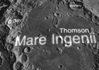
PDS has now implemented the Planetary Image Atlas search for LRO data, especially images. Go to the geometry tab, enter min and max lat and long (negative lat for south, longitudes measured to the east), and it will find LROC images for you. Best for browsing purposes, you can display and save a jpeg browse image.
http://pds-imaging.jpl.nasa.gov/search/sea...tml#QuickSearch Phil -------------------- ... because the Solar System ain't gonna map itself.
Also to be found posting similar content on https://mastodon.social/@PhilStooke NOTE: everything created by me which I post on UMSF is considered to be in the public domain (NOT CC, public domain) |
 |
 
|
|
Mar 16 2010, 07:22 PM
Post
#32
|
|
|
Junior Member Group: Members Posts: 22 Joined: 20-June 09 Member No.: 4830 |
QUOTE (Rick Sternbach @ Mar 16 2010, 12:20 PM)  They have: 45 degrees north and south at (I believe) 100 meters/pixel, 200m/px, 400m/px in the same formats. 60 degrees north and south at 120m/px, 240m/px 75 degrees north and south at 30m/px, 60m/px, 120m/px 80 degrees north and south at 20m/px, 40m/px, 80m/px 85 degrees north and south at 10m/px, 20m/px, 40m/px 87.5 degrees north and south at 5m/px, 10m/px, 20m/px Correct. Polar maps are in stereographic projection (true scale at the pole, R=1737.4km). QUOTE (Rick Sternbach @ Mar 16 2010, 12:20 PM) They offer the whole moon unwrapped as a cylindrical map at 4, 16, and 64 pixels per degree, in JPEG2000, .IMG, .GRD formats. Personally, I have no idea how to use the .GRD, so I'm sticking to the JPEG2000 and .IMG files. The GRD are netcdf-binaries, created with the GMT package (gmt.soest.hawaii.edu). They are double-precision, unlike the IMG and JP2 which are downconverted to 16bit. GMT can convert those to binary 3-column (with grd2xyz), but any netcdf-reader will do. QUOTE (Rick Sternbach @ Mar 16 2010, 12:20 PM) I'm going to assume that with more orbits and more laser points recorded, the density of detail will just keep going up, as will the file size. I need a new computer. With more orbits, the gaps between tracks will be reduced (density of detail), but the file sizes should not change. If your computer can handle those, it will be fine with the future releases  Erwan |
|
|
|
|
Mar 16 2010, 08:08 PM
Post
#33
|
|
|
Junior Member Group: Members Posts: 23 Joined: 6-November 09 Member No.: 5017 |
Erwan,
I haven't a clue what netcdf-binaries are, so I'll stick to the .img and JP2 files. However, I have a question about the files other than the complete cylindrical maps. I downloaded one of the 45S JP2 files, and all I see is a single 7200x7200 pixel image. Is there more of 45S somewhere, or can I not see the rest of that latitude because Photoshop isn't made to do that? Or has the rest of that latitude not been released yet? EDIT: Okay, I see what's going on; the north and south files are closer and more detailed views centered on the poles, so this isn't like the MOLA files going around in longitude for each latitude increment. This means I'm going to have to wait for 128 or 256 or higher pixels/degree for a feature like Copernicus. Hmmm. Rick |
|
|
|
|
Mar 16 2010, 10:50 PM
Post
#34
|
|
|
Junior Member Group: Members Posts: 22 Joined: 20-June 09 Member No.: 4830 |
QUOTE (Rick Sternbach @ Mar 16 2010, 03:08 PM) I haven't a clue what netcdf-binaries are, so I'll stick to the .img and JP2 files. However, I have a question about the files other than the complete cylindrical maps. I downloaded one of the 45S JP2 files, and all I see is a single 7200x7200 pixel image. Is there more of 45S somewhere, or can I not see the rest of that latitude because Photoshop isn't made to do that? Or has the rest of that latitude not been released yet? netcdf : http://www.unidata.ucar.edu/software/netcdf/ ; libraries allow such files to be used in various programs/platforms this is a stereographic projection, so the sphere was projected onto a plane. This particular grid you mention extends to +/- 1440km in both directions. The projection of a point at 45degS from the south pole is ~1440km away from the pole, hence the name. Such points are at the center of each side. However, when you are at a corner of the grid, at a distance of 1440*sqrt(2)~2037km, you are actually at 29.25degS. The 45deg latitude circle would be a circle that is nearly tangent to the top-center, right-center, bottom-center and left-center point. (it's like http://www.colorado.edu/geography/gcraft/n.../mapproj_f.html, but we're putting out a square grid instead of a disc). Erwan |
|
|
|
|
Mar 16 2010, 11:16 PM
Post
#35
|
|
|
Junior Member Group: Members Posts: 23 Joined: 6-November 09 Member No.: 5017 |
Erwan,
Okay, I get it now, as I attempted to convey in my edited comment.  I'll still assume we have to wait for much higher-rez data on Copernicus. - Rick I'll still assume we have to wait for much higher-rez data on Copernicus. - Rick
|
|
|
|
|
Mar 17 2010, 12:43 AM
Post
#36
|
||
 Senior Member Group: Moderator Posts: 3431 Joined: 11-August 04 From: USA Member No.: 98 |
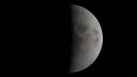
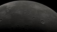
This is a great data release. The work that's been done to make the LOLA data accessible is much appreciated. What's even more exciting is that the data set should keep getting better. It's already better than I was expecting for this first release.
Below is a view from a possible future version of Moon Globe, after just a couple hours monkeying around. I have one technical question for Erwan: Is the data in LDEM_64.IMG signed? From the header file LDEM_64.LBL.txt I would expect it to be a signed integer offset from 1,737,400m with a scaling factor of 0.5; however, the data appears to be unsigned integer, not signed. It makes me wonder about the noted offset and scaling factor. Thanks!
Attached thumbnail(s)
|
|
|
|
|
|
|
Mar 17 2010, 06:35 AM
Post
#37
|
|
 The Poet Dude Group: Moderator Posts: 5551 Joined: 15-March 04 From: Kendal, Cumbria, UK Member No.: 60 |
-------------------- |
|
|
|
|
Mar 17 2010, 01:25 PM
Post
#38
|
|
|
Newbie Group: Members Posts: 4 Joined: 12-November 09 Member No.: 5040 |
Wow, excellent!
On which RAW was it sitting in?
|
|
|
|
|
Mar 17 2010, 01:29 PM
Post
#39
|
|
|
Junior Member Group: Members Posts: 22 Joined: 20-June 09 Member No.: 4830 |
QUOTE (mhoward @ Mar 16 2010, 08:43 PM) I have one technical question for Erwan: Is the data in LDEM_64.IMG signed? From the header file LDEM_64.LBL.txt I would expect it to be a signed integer offset from 1,737,400m with a scaling factor of 0.5; however, the data appears to be unsigned integer, not signed. It makes me wonder about the noted offset and scaling factor. actually, thanks for finding that out (and reading the doc first ). The cylindrical IMGs had a problem. They should now be fine (signed int16), so please redownload... Alternatively, you could download the smaller JP2 and decompress it to a raw binary file. For example, with "kdu_expand" by Kakadu Software (http://www.kakadusoftware.com/index.php).
|
|
|
|
|
Mar 17 2010, 05:15 PM
Post
#40
|
|||||||
|
Founder Group: Chairman Posts: 14432 Joined: 8-February 04 Member No.: 1 |
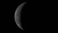
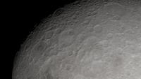
Just playing with the 64 ppd for now - but great stuff!!
Attached thumbnail(s)
|
||||||
|
|
|
||||||
|
Mar 17 2010, 05:26 PM
Post
#41
|
|||
|
Senior Member Group: Moderator Posts: 3431 Joined: 11-August 04 From: USA Member No.: 98 |
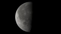
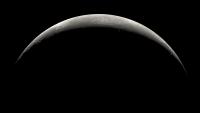
QUOTE (zeBeamer @ Mar 17 2010, 07:29 AM) thanks for finding that out Thanks for fixing it. It looks right to me now. With that fixed, here's a direct comparison between a Moon Globe using the available LALT data, and the same view using the new LOLA data. The LOLA-based view wins. I'm really surprised that the LOLA data is this sharp this early.
Attached thumbnail(s)
|
||
|
|
|
||
|
Mar 17 2010, 09:12 PM
Post
#42
|
|
 Administrator Group: Admin Posts: 5172 Joined: 4-August 05 From: Pasadena, CA, USA, Earth Member No.: 454 |
OK folks, I am stumped. I have downloaded a couple of LROC images but cannot manage to open and work with them. Photoshop CS3 chokes on them when I attempt to open as raw using the width and height specified in the header. IMG2PNG refuses to convert them to PNG format. NasaView can open the image but converts down to 8 bit mode as it does so, and the contrast is so low that all of the pixels are in like 7 of the DNs. I tried GIMP (I have the PDS import filter installed) but it just hangs. What else can I try on a Windows machine? Help!!
-------------------- My website - My Patreon - @elakdawalla on Twitter - Please support unmannedspaceflight.com by donating here.
|
|
|
|
|
Mar 17 2010, 10:59 PM
Post
#43
|
|
|
Founder Group: Chairman Posts: 14432 Joined: 8-February 04 Member No.: 1 |
Emailing someone with ISIS is probably your best bet.
Alternatively, try ImageJ and importing a raw into that. |
|
|
|
|
Mar 18 2010, 01:22 AM
Post
#44
|
|
|
Junior Member Group: Members Posts: 23 Joined: 6-November 09 Member No.: 5017 |
I'm not terribly savvy about all of the data products that are coming, but are we going to see a full cylindrical "texture map" type of image, a la what we saw with Clementine? A giant WAC mosaic of some kind? - Rick
|
|
|
|
|
Mar 18 2010, 04:25 AM
Post
#45
|
|
|
Member Group: Members Posts: 890 Joined: 18-November 08 Member No.: 4489 |
IMG2PNG might not work for them
i have found that not just the *.lbl BUT the .img files for the LDEM_4.LBL LDEM_4.IMG LDEM_16.LBL LDEM_16.IMG LDEM_64.LBL LDEM_64.IMG all of the lbl's are F-'ed up ( this is NOT an exaggeration) the headers state 3 different bit formats and as 16 bit the IMG files ARE 32 bit however ther really are 16 bit images saved as 32 bit ??? also the "SCALING_FACTOR" and "OFFSET" are off yes this is messed up this is the LBL for the LDEM_64.IMG that i just made , and WORKS this opens it as a 16 bit image CODE PDS_VERSION_ID = "PDS3" /*** FILE FORMAT ***/ FILE_RECORDS = 11520 RECORD_TYPE = FIXED_LENGTH RECORD_BYTES = 46080 ^IMAGE = "LDEM_64.IMG" /*** GENERAL DATA DESCRIPTION PARAMETERS ***/ PRODUCT_VERSION_ID = "V1 revision F" DATA_SET_ID = "LRO-L-LOLA-64-GDR-V1.0" PRODUCT_ID = "LDEM_64.IMG" INSTRUMENT_HOST_NAME = "LUNAR RECONNAISSANCE ORBITER" INSTRUMENT_NAME = "LUNAR ORBITER LASER ALTIMETER" INSTRUMENT_ID = "LOLA" COORDINATE_SYSTEM_NAME = "MEAN EARTH/POLAR AXIS OF DE421" MISSION_PHASE_NAME = {"COMMISSIONING","NOMINAL MISSION"} TARGET_NAME = MOON START_TIME = 2009-07-13T17:33:17.246 STOP_TIME = 2009-12-17T19:42:52.026 PRODUCT_CREATION_TIME = 2010-03-01T00:00:00 PRODUCER_ID = LRO_LOLA_TEAM PRODUCER_FULL_NAME = "DAVID E. SMITH" PRODUCER_INSTITUTION_NAME = "GODDARD SPACE FLIGHT CENTER" DESCRIPTION = "This data product is a shape map (radius) of the Moon at a resolution of 64 pixels per degree" OBJECT = IMAGE NAME = HEIGHT DESCRIPTION = "" LINES = 11520 LINE_SAMPLES = 23040 SAMPLE_TYPE = LSB_UNSIGNED_INTEGER SAMPLE_BITS = 16 UNIT = METER SCALING_FACTOR = 1.0 OFFSET = 0 END_OBJECT = IMAGE OBJECT = IMAGE_MAP_PROJECTION ^DATA_SET_MAP_PROJECTION = "DSMAP.CAT" MAP_PROJECTION_TYPE = "SIMPLE CYLINDRICAL" A_AXIS_RADIUS = 1737.4 <KM> B_AXIS_RADIUS = 1737.4 <KM> C_AXIS_RADIUS = 1737.4 <KM> FIRST_STANDARD_PARALLEL = "N/A" SECOND_STANDARD_PARALLEL = "N/A" POSITIVE_LONGITUDE_DIRECTION = "EAST" CENTER_LATITUDE = 0.0 <DEGREE> CENTER_LONGITUDE = 180.0 <DEGREE> REFERENCE_LATITUDE = "N/A" REFERENCE_LONGITUDE = "N/A" LINE_FIRST_PIXEL = 1 LINE_LAST_PIXEL = 11520 SAMPLE_FIRST_PIXEL = 1 SAMPLE_LAST_PIXEL = 23040 MAP_PROJECTION_ROTATION = 0.0 MAP_RESOLUTION = 64.0 <PIXEL/DEGREE> MAP_SCALE = 0.47375 <KM/PIXEL> MAXIMUM_LATITUDE = 90.0 <DEGREE> MINIMUM_LATITUDE = -90.0 <DEGREE> WESTERNMOST_LONGITUDE = 0.0 <DEGREE> EASTERNMOST_LONGITUDE = 360.0 <DEGREE> LINE_PROJECTION_OFFSET = 0.0 SAMPLE_PROJECTION_OFFSET = 0.0 COORDINATE_SYSTEM_TYPE = "BODY-FIXED ROTATING" COORDINATE_SYSTEM_NAME = "MEAN EARTH/POLAR AXIS OF DE421" END_OBJECT = IMAGE_MAP_PROJECTION END however you will find that in isis the map projection is off .It is in sym cyl BUT the lat/long are way off you will need to run maplab on it |
|
|
|
|

|
Lo-Fi Version | Time is now: 24th April 2024 - 10:22 AM |
|
RULES AND GUIDELINES Please read the Forum Rules and Guidelines before posting. IMAGE COPYRIGHT |
OPINIONS AND MODERATION Opinions expressed on UnmannedSpaceflight.com are those of the individual posters and do not necessarily reflect the opinions of UnmannedSpaceflight.com or The Planetary Society. The all-volunteer UnmannedSpaceflight.com moderation team is wholly independent of The Planetary Society. The Planetary Society has no influence over decisions made by the UnmannedSpaceflight.com moderators. |
SUPPORT THE FORUM Unmannedspaceflight.com is funded by the Planetary Society. Please consider supporting our work and many other projects by donating to the Society or becoming a member. |
|