The Top of Vera Rubin Ridge Part 2, Site 67-73, sol 1944-2297, 24 Jan 2018-22 Jan 2019 |

  |
The Top of Vera Rubin Ridge Part 2, Site 67-73, sol 1944-2297, 24 Jan 2018-22 Jan 2019 |
 Sep 14 2018, 10:33 AM Sep 14 2018, 10:33 AM
Post
#481
|
|
 Senior Member  Group: Members Posts: 2428 Joined: 30-January 13 From: Penang, Malaysia. Member No.: 6853 |
Looking at the HazCam thumbs for sol 2170, I believe it could have been a very good day on Mars
 Link #18? Link #18?
|
 |
 
|
|
Sep 14 2018, 06:42 PM
Post
#482
|
|
|
Solar System Cartographer Group: Members Posts: 10150 Joined: 5-April 05 From: Canada Member No.: 227 |
http://www.midnightplanets.com/web/MSL/ima...CAM01170L1.html
Not so sure, that looks like a shallow hole. Too shallow. Phil -------------------- ... because the Solar System ain't gonna map itself.
Also to be found posting similar content on https://mastodon.social/@PhilStooke NOTE: everything created by me which I post on UMSF is considered to be in the public domain (NOT CC, public domain) |
|
|
|
|
Sep 14 2018, 08:36 PM
Post
#483
|
|
|
Senior Member Group: Members Posts: 2428 Joined: 30-January 13 From: Penang, Malaysia. Member No.: 6853 |
QUOTE (Phil Stooke @ Sep 15 2018, 02:42 AM)  Not so sure, that looks like a shallow hole. Too shallow These are tough rocks for FED 
|
|
|
|
|
Sep 14 2018, 08:44 PM
Post
#484
|
|
|
Founder Group: Chairman Posts: 14432 Joined: 8-February 04 Member No.: 1 |
QUOTE (PaulH51 @ Sep 14 2018, 01:36 PM) These are tough rocks for FED They would have been just as tough for the as-planned drilling techniques when the rover landed. ( I asked that very question of the engineer who has wrangled the FED stuff ) |
|
|
|
|
Sep 14 2018, 09:06 PM
Post
#485
|
|
 Member Group: Members Posts: 809 Joined: 3-June 04 From: Brittany, France Member No.: 79 |
A beautiful panorama on the foothills of Mount Sharp taken on sol 2166. It's part of a 360° panorama but all pictures are not yet arrived.
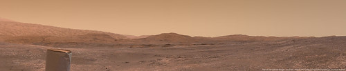 And three cropped versions of that panorama: 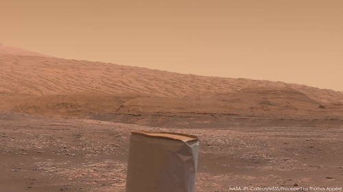 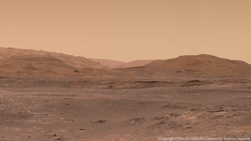 
-------------------- |
|
|
|
|
Sep 14 2018, 11:26 PM
Post
#486
|
|
|
Senior Member Group: Members Posts: 1074 Joined: 21-September 07 From: Québec, Canada Member No.: 3908 |
Beautiful, neo56.
Too bad the raw images are posted un-Debayered. I tried various ways to Debayer the mastcam images, but without success, and I don't have much time to explore other avenues. I was wondering if someone could find a way to automate the process and post the raw Debayed images somewhere so that the less proficient of us in image manipulation could assemble them. |
|
|
|
|
Sep 16 2018, 07:11 AM
Post
#487
|
||
|
Senior Member Group: Members Posts: 2428 Joined: 30-January 13 From: Penang, Malaysia. Member No.: 6853 |
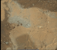
Spot the Difference: Dust / fines being displaced by LIBS, fines and drill cuttings (tailings) dispersed by the wind.
An animated GIF assembled and roughly aligned from a pair of right side mast camera images featuring the same patch of ground in front of the rover ~24 hours apart (sols 2170 & 2171) I believe there are 4 named targets in this frame:- 1) The drill target "Inverness". 2) A ChemCam (LIBS) target "Black Isle", a grey, raised, nodular feature just above the drill hole. 3) A ChemCam (LIBS) target "Grange", a white patch, just right of the drill hole. 4) A Micro Image target called "Pentland" consisting of large veins, just below the drill hole.
|
|
|
|
|
|
|
Sep 16 2018, 07:24 AM
Post
#488
|
|
|
Senior Member Group: Members Posts: 1043 Joined: 17-February 09 Member No.: 4605 |
On an intuitive level the failure to drill does not surprise. The four prior attempts show increasing toughness with ridge elevation. If one of the criteria for defining the three members of the ridge was the apparent susceptibility to erosion, which I believe I have seen mentioned elsewhere, Stoer would seem more comfortably aligned to the Blunts Point Member and Duluth rather than the upper Pettigrove Point Member.
|
|
|
|
|
Sep 16 2018, 04:33 PM
Post
#489
|
|
|
Senior Member Group: Members Posts: 2511 Joined: 13-September 05 Member No.: 497 |
QUOTE (charborob @ Sep 14 2018, 03:26 PM) I was wondering if someone could find a way to automate the process... If you have OpenCV2 and Python the following fragment will interpolate a Bayer JPEG: CODE import cv2
i = cv2.imread("2169MR0116860040105687C00_DXXX.jpg") i2 = cv2.cvtColor(cv2.cvtColor(i, cv2.COLOR_RGB2GRAY), cv2.COLOR_BAYER_BG2BGR) cv2.imwrite("color.png", i2) -------------------- Disclaimer: This post is based on public information only. Any opinions are my own.
|
|
|
|
|
Sep 16 2018, 04:52 PM
Post
#490
|
|
 Senior Member Group: Members Posts: 4246 Joined: 17-January 05 Member No.: 152 |
This thread discussed deBayering.
Using command line gmic is very simple and it works pretty well, as discussed in this post. That could be easily scripted, identifying the Bayered images with the "C" identifier. |
|
|
|
|
Sep 18 2018, 12:03 PM
Post
#491
|
|
|
Member Group: Members Posts: 923 Joined: 10-November 15 Member No.: 7837 |
Charobob,
Here is my process for DeBayerin'.... Install GIMP 2.1.0 Open all Debayered files using 'Open as layers' and selecting all images you want to convert. Switch Mode to RGB Open 'G'Mic-QT' filter interface under Filters menu Under Repair, select 'Bayer reconstruction'...experiment with different values to get the result you want. ( I use 8, 8, 6 ) ( No preview so you have to commit to see results ) This will give you a color image where there was black and white. I then select the next layer and 'Repeat last filter' command [Ctrl+F]...for all the images you want to convert. ...this is the only tedious part but it shouldn't take too long. I'm sure its also possible to set up a batch process that would execute the filter on all the images you need. Hope that helps. -------------------- |
|
|
|
|
Sep 18 2018, 09:20 PM
Post
#492
|
|
|
Solar System Cartographer Group: Members Posts: 10150 Joined: 5-April 05 From: Canada Member No.: 227 |
There's a bit of a hangup in getting new images, but by now we should have moved again. The plan is to drive to Lake Orcadie, where drill tests were done 100 sols ago or so.
Phil -------------------- ... because the Solar System ain't gonna map itself.
Also to be found posting similar content on https://mastodon.social/@PhilStooke NOTE: everything created by me which I post on UMSF is considered to be in the public domain (NOT CC, public domain) |
|
|
|
|
Sep 19 2018, 05:51 PM
Post
#493
|
|
|
Founder Group: Chairman Posts: 14432 Joined: 8-February 04 Member No.: 1 |
There may not be any new images for a while
https://mars.nasa.gov/msl/mission/mars-rove...we-want-to-help "Besides transmitting data recorded in its memory, the rover can transmit "real-time" data when it links to a relay orbiter or Deep Space Network antenna. These real-time data are transmitting normally, and include various details about the rover's status. Engineers are expanding the details the rover transmits in these real-time data to better diagnose the issue. Because the amount of data coming down is limited, it might take some time for the engineering team to diagnose the problem." |
|
|
|
|
Sep 20 2018, 09:38 PM
Post
#494
|
|
|
Senior Member Group: Members Posts: 2428 Joined: 30-January 13 From: Penang, Malaysia. Member No.: 6853 |
Three MastCam images from sol 2081 are highlighted on the JPL server as new. Link
I guess these could be an indication that they have managed to extract them from the memory, which would be welcome news, or they could just be older images that were already with JPL but not yet released into the public server. Time will tell... |
|
|
|
|
Sep 20 2018, 10:33 PM
Post
#495
|
|
|
Founder Group: Chairman Posts: 14432 Joined: 8-February 04 Member No.: 1 |
They're just a ground data system burp of data.
|
|
|
|
|

|
Lo-Fi Version | Time is now: 24th April 2024 - 12:30 PM |
|
RULES AND GUIDELINES Please read the Forum Rules and Guidelines before posting. IMAGE COPYRIGHT |
OPINIONS AND MODERATION Opinions expressed on UnmannedSpaceflight.com are those of the individual posters and do not necessarily reflect the opinions of UnmannedSpaceflight.com or The Planetary Society. The all-volunteer UnmannedSpaceflight.com moderation team is wholly independent of The Planetary Society. The Planetary Society has no influence over decisions made by the UnmannedSpaceflight.com moderators. |
SUPPORT THE FORUM Unmannedspaceflight.com is funded by the Planetary Society. Please consider supporting our work and many other projects by donating to the Society or becoming a member. |
|