Printable Version of Topic
Click here to view this topic in its original format
Unmanned Spaceflight.com _ Tianwen 1- 2020 Orbiter/Lander _ Zhurong maps
Posted by: Phil Stooke May 19 2021, 11:46 PM
I'm starting a map thread. It's hard to know what we will get but I expect a route map will emerge bit by bit. Maps showing the landing location will be easier to make initially.
Phil
Posted by: Phil Stooke May 22 2021, 05:14 PM
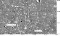
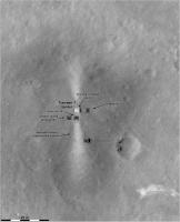
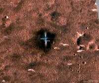
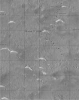
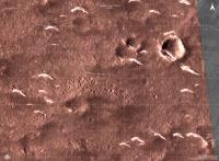
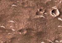
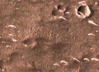
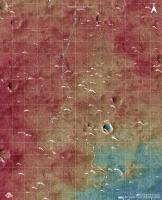
Starting off with an overview of the site, with landing ellipses based on the work done at Hong Kong Polytechnic University. The initial site is indicated. The landing ellipse is about 60 by 20 km and if you center one at the initial site it contains two craters with rough ejecta blankets (bright in this image, which is Mars Odyssey THEMIS infrared with inverted shading). Two nearby ellipses were chosen to avoid the craters, and the western one was then moved a bit to avoid more rough terrain at its southern end. The landing site is very close to the center of that ellipse and about 40 km from the initial site.
Phil
|
Posted by: Greenish May 23 2021, 03:55 AM
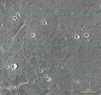
Until higher-res imagery arrives, here's a crop at CTX full-res (5.67 m/px) with a circle roughly at the dot in Phil's ellipse map. (merge of 2 CTX tiffs - 1km squares for scale reference but not referring to any particular origin)
I think the distance from center to edge of the image, about 3.5km, is the horizon distance from about 1.7m height on Mars.
|
Posted by: Phil Stooke Jun 10 2021, 07:20 AM
It's clear that following this mission will be tricky and maps will be tentative and only sporadically updated for a while.
But you have to start somewhere. This is a VERY tentative start. A HiRISE image will improve the basemap, and eventually a reprojected panorama can be laid over that.
What I show here is all I know at present. I will update it when we get news. Let me know if anything else appears! I am assuming landing day was sol 0 but that may not be correct.
Phil
|
Posted by: Phil Stooke Jun 10 2021, 08:08 PM
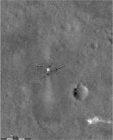
OK, HiRISE image and a new location.
Phil
|
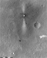
Posted by: Phil Stooke Jun 11 2021, 07:45 AM
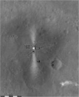
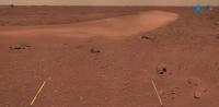
The text accompanying the 'group photo' of the rover and lander together says that the camera was deployed 10 m south of the lander. Then the rover moved back towards the lander for the photo. I have illustrated that here (using a guess as to the locations of the camera and the rover during photography). All very uncertain of course. I don't think the date of the group photo was mentioned - before or after the Tianwen-1 orbiter image, so I can't add a date.
All this is subject to ongoing revision.
Phil
|
Posted by: kymani76 Jun 12 2021, 11:34 AM
I'm a bit late to the game as I had other work, but it's finally time for me to catch up with all the events.
|
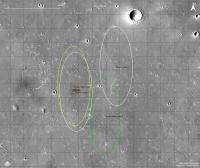
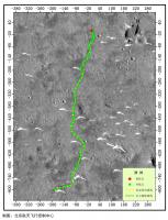
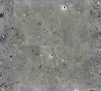
Revised landing ellipses map, with initial one in green and final one in yellow. Grid is at 10 km with smaller landing site quadrants at 1 km.
Posted by: kymani76 Jun 12 2021, 11:38 AM
|
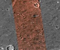
All landed hardware map in HiRise color. Grid at 1km.
Posted by: kymani76 Jun 12 2021, 11:46 AM
|
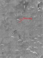
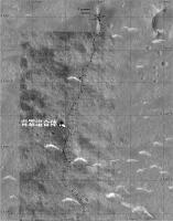
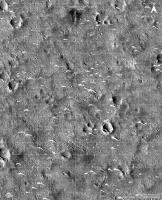
Traverse map, based on tracks visible when enhancing HiRise image. Note the small area size of the map. I get 75m of distance from track in close aligment with reported 80m distance.
Grid at 10m.
|
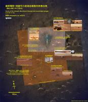
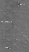
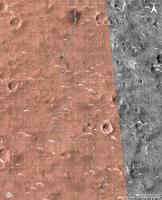
Wider landing map in color, with engine exhaust obscuring the area of recent activity. Grid at 100m.
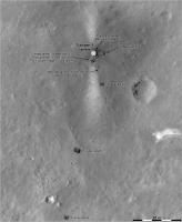
Posted by: Phil Stooke Jun 24 2021, 03:56 AM
After the second HiRISE image appeared I have made some big changes to my map. I decided that the dark markings west of the bright streak are probably not tracks after all - especially if you overlay the two HiRISE images, which makes the tracks east of the streak easier to see and the others less distinct. I also changed my interpretation of the 'group photo' from the deployed camera. The foreground surface in that image is more red on the left side and middle, and darker and less red on the right. I was interpreting that as showing the surface from the west side of the streak but now I think it's from the east, and that seems to match the geometry of the lander better as well.
All that may still be wrong! A Chinese map would be very useful. Until we get one HiRISE may be our best guide.
Phil
|
Posted by: Phil Stooke Jun 27 2021, 07:31 PM
Bit by bit a map takes shape. This uses the new panorama.
Phil
|
Posted by: Phil Stooke Jun 27 2021, 08:25 PM
And an overview map - this will be the standard resolution for mapping.
Phil
|
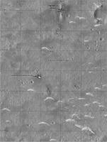
Posted by: Huguet Jul 9 2021, 02:27 PM
And Zhurong is almost at the parachute... Would be nice to get a new Hirise.
Huge image with a recent path nice guess from here:
https://twitter.com/TheElegant055/status/1413594702054674432
Link to 50MB full resolution version:
https://drive.google.com/drive/folders/19PTSvxpEc0hlSnaGYTILuTgwRZE4Mk8E
|
|
|
|
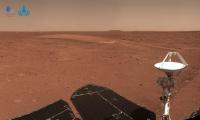
Posted by: Bill Harris Jul 9 2021, 08:11 PM
So, those light-toned features are barchan-like dunes. Wonder if we can determine the composition of these dunes? Or what the source of this material is?
--Bill
Posted by: Phil Stooke Jul 9 2021, 09:25 PM
The LIBS instrument will give composition - they were within LIBS range.
There are dark dunes on Mars (e.g. Bagnold Dunes in Gale Crater) and bright features like this, usually called drifts or ripples. The dark features are made of basaltic sand and they can indeed by barchans - see also the Greeley Dune Field inside Endeavour crater. These brighter features are made of finer material, silt to dust sized particles. The reason the dark and light don't just mix to form mid-toned deposits is that the wind sorts particles by size. That finer material is probably mixed globally and doesn't tell much about local geology.
(Continue discussion in the other thread)
Here is a very rough update to the map using the new information. A new HiRISE image would be very useful! (or a Chinese map)
Phil
|
Posted by: Huguet Jul 11 2021, 03:34 PM
https://news.cgtn.com/news/2021-07-11/China-s-Zhurong-rover-drives-for-over-410-meters-on-Mars-11OJM3iid5C/index.html
I believe, this means, we will get some parachute close-ups soon.
http://www.chinanews.com/gn/2021/07-11/9517522.shtml
"According to news from the National Space Administration, as of today (July 11) at 20 o'clock, the "Zhu Rong" rover has traveled a total of 410.025 meters and operating conditions are normal."
Posted by: Phil Stooke Jul 15 2021, 05:37 PM
I updated my map with the parachute images. The sol dates might be one sol out depending on exact timing. The sol 56 marker is where I think the approach Hazcam image was taken, but only an approximate location.
Phil
|
Posted by: kymani76 Jul 16 2021, 09:07 PM
|
As usual Phil beat me to the update, bur anyway here is my take, color version. Track total is about 420m.
Posted by: Phil Stooke Jul 16 2021, 09:54 PM
You are doing some really nice work here - for all missions! Thanks.
Phil
Posted by: kymani76 Jul 18 2021, 07:43 PM
Thanks Phil. Means a lot. In fact you just gave me an idea to add the fourth one. See Exomars thread post #570.
Posted by: Phil Stooke Jul 19 2021, 06:31 PM
I just had an interesting and very welcome email from a reader of the forum who corrected me on my estimated sol numbers. I have updated my map with the corrected numbers and added an approximate location near the second dune - I am not sure which sol the rover arrived near that dune but we may know it after new images are released.
Corrections are always welcome - we really need as many eyes on this as possible.
Phil
|
Posted by: Phil Stooke Jul 23 2021, 07:13 AM
The Chinese map I linked to in the main thread lets me improve my map.
Phil
|
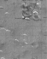
Posted by: Phil Stooke Jul 31 2021, 07:21 AM
My best guess for sol 75 would be right at the bottom of my map.
The query after 'c. 72' is for the date. The location is good.
Phil
|
Posted by: kymani76 Aug 1 2021, 10:52 AM
|
Tentative sol 75 update. I left the dates out, because I'm not sure whether UTC or Chinese time is used for counting.
I also improved on base HiRise image, although color balance is hard with these images.
Total track is 708 meters in length.
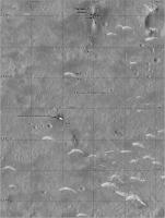
Posted by: Hungry4info Aug 17 2021, 08:30 PM
New drive map from https://mp.weixin.qq.com/s/nneKWbj2Zyp0tJ_1-3cjmA.
|
Posted by: Bill Harris Aug 19 2021, 05:26 AM
I give them passing marks on autonomous driving (or for careful directed driving).
--Bill
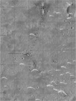
Posted by: ollopa Aug 20 2021, 05:15 PM

Phil
|
|
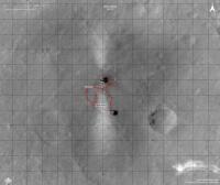
Phil: I am really struggling to reconcile the scale bar in this scene with everything else I have seen. 40 km between the dots is not what the scalebar says? Am I right? All of which is interesting because I simply don't understand why they didn't go north. If "dot-to-dot" is 40 km, then the prominent pitted cone to the NW is barely 10 km away, whereas the cones to the south are at least 20 km away, maybe a good bit more.
This stuff is way beyond my payscale: can anyone show a wider regional map with distances to key features, compared to the total traverse so far?
I realise "Why didn't they go North" is a different topic, but IMHO it has to begin with scale comparisons of other target options in the scene. We should have a HiRISE DTM of the landing site area very soon, but I am very sensitive to the fact that people who might like to weigh in here are being very *very* careful in order (I assume) to preserve valuable contacts in Utopia!
Posted by: Phil Stooke Aug 21 2021, 01:32 AM
You are right, it should be more like 30 km between dots. I don't remember where the 40 km came from but it doesn't match the map. I might have been quoting some other source or just put too much Baileys on my cornflakes that morning.
I think they want to use the ground-penetrating radar on a trough about 1700 m south of the current position, which would be an interesting thing to do. Then keep going that way and hope to reach a cone.
Phil
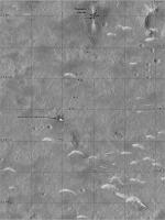
Posted by: Hungry4info Aug 30 2021, 10:29 AM
New drive map from https://twitter.com/CNSAWatcher/status/1432279954868350977.
|
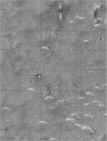
Posted by: Phil Stooke Aug 30 2021, 05:41 PM
This map is very useful, but I am intrigued to find that it does not overlay the new orbiter image of the track very precisely. I will wait until we have a new HiRISE image before updating my map. The orbiter image was taken on 24 August and this map matches that except for the last point, so this map was probably made with data up to 23 August, a week prior to release.
Phil
Posted by: Huguet Aug 31 2021, 12:13 AM
Amazing how detailed the orbiter get the track... a single track on Tianwen-1,.. Hirise will indeed be nice with its better resolution and seeing the 2 track path.
|
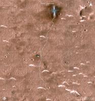
Posted by: Phil Stooke Sep 17 2021, 05:45 PM
We have had no news on Tianwen-1 and Zhurong for a while. The rover at least, and probably the orbiter too, are entering a superior conjunction blackout period about now. Their blackout will be longer than NASA's, probably because it's the first time they have dealt with it and will want to be more conservative.
Meanwhile I wanted to show the difference between the existing map and the new Tianwen-1 orbiter image. My map is based on the published map with track and waypoints. The orbiter image shows tracks offset from it, with the offset increasing away from the lander (though the last point is close again). I suspect this is because of a small difference in the definitions of map projections between the projected orbiter image and the route map. (My coordinates are from HiRISE which opens the possibility of another offset, but in all cases I am matching to surface features using HiRISE as a standard). The maximum offset is about 10 m.
Phil
|
|
Posted by: Bill Harris Sep 18 2021, 01:51 PM
Agreed. The 'quiet spell' from Zhurong is not to be worried about. They don't have an as-established DSN infrastructure or as much experience with dealing with a faint, noisy signal.
I'm still impressed with their Rover's track. I don't know how on-course it is, but it doesn't seem to be bumping into things...
--Bill
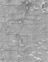
Posted by: Phil Stooke Nov 8 2021, 08:09 PM
Here is an update to my map (section 2) based on this site:
https://mp.weixin.qq.com/s/NImpyH43GAhMnF0dkpU1jA
(thanks to Andrew Jones for tweeting about it).
I have not yet corrected it to fit the tracks seen in orbital images. I will wait for a new HiRISE image to do that.
Phil
|
Posted by: kymani76 Dec 24 2021, 09:26 AM
|
Recently new geological map for Zhurong landing site was made available in this artilcle:
https://doi.org/10.1016/j.icarus.2021.114657.
I turned their data into this map using same symbology and adding some new IAU approved feature names.
Posted by: kymani76 Dec 24 2021, 09:30 AM
|
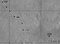
Sol 174 map update.
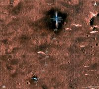
Posted by: Phil Stooke Jan 1 2022, 08:10 AM
A very quick look at the end of year location. The new partial panorama is looking southeast and it leads to this position. I will post a proper map when I can get to it.
Phil
|
Posted by: kymani76 Jan 4 2022, 02:23 PM
|
Sol 201 update in IRG color, based on latest image from Zhurong. The rover itself has already moved a little further to the SE since.

|
3D perspective based on HiRise terrain model, with roughly the same perspective as published image.
Posted by: Phil Stooke Jan 4 2022, 09:22 PM
I assumed the partial panorama was from the end of year date, but if it is from sol 201 I will correct my map. I am still hoping for a new HiRISE image to guide my next map. There are small differences beteen the various sources we have.
Phil
Posted by: Bill Harris Jan 5 2022, 02:51 AM
Sol 201 update in IRG color, based on latest image from Zhurong. The rover itself has already moved a little further to the SE since.
attachment=50067:tianwen1..._3D_r001.jpg
3D perspective based on HiRise terrain model, with roughly the same perspective as published image.
They are avoiding driving over that patch of pitted terrain, but hopefully will stop for a closer look.
Nice 3D perspective!
--Bill
Posted by: kymani76 Jan 5 2022, 08:03 PM
Nice 3D perspective!
--Bill
Thank you, Jaka
Posted by: kymani76 Mar 15 2022, 04:34 PM
|
Preliminary sol 262 map update, based on this map found https://drive.google.com/drive/folders/19PTSvxpEc0hlSnaGYTILuTgwRZE4Mk8E.
I have no other source of info, but I'm sure the track distances on this map don't add up.
Posted by: kymani76 Mar 22 2022, 12:25 PM
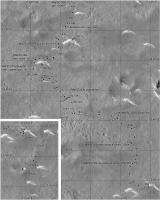
Recent article characterizing first 60 sols of Zhurong traverse was published in https://www.nature.com/articles/s41561-022-00905-6.
While the article is sadly behind paywall it is possible to download supplemental files which include rover's track points.
Here is a comparison map of my version of traverse vs the new track points in red:
|
Posted by: kymani76 Mar 24 2022, 04:44 PM
Zhurong traverse updated with track visible in new HiRise photo https://www.uahirise.org/ESP_073225_2055.
I also updated positions for sols 0-60 with date mentioned in previous post and manage to extend coverage to sol 75. Sols after that are approximate.
The Chinese data veers off course to the east when compared to track visible in HiRise photo, so I corrected its position to nearest point in the track.
|
|
1. Whole track from the landing 2. Zoom in to the latest sol 297(?) position on 03/11/2022.
Posted by: kymani76 Mar 24 2022, 04:48 PM
|
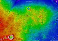
In addition I also made elevation map with the new track plotted. It seems like Zhurong landed on "peninsula" and is headed to the "beach" now.
Posted by: vikingmars Mar 24 2022, 06:28 PM
What a great work of yours Kymani76 !
Congratulations

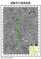
Posted by: kymani76 Mar 10 2023, 08:53 AM
Zhurong rover map update. There is not a lot of new info, just the drive from sol 297 position to the (final?) position.
This last segment of the drive did not leave rover tracks visible in HiRise imagery, so its course is a bit conjectural.
BW version:
|
Posted by: kymani76 Mar 10 2023, 08:56 AM
false color IRG image version:
|
DEM version:
|
Posted by: vikingmars Mar 13 2023, 02:28 PM
What a nice work!
Congratulations kymani76
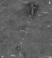
Posted by: Phil Stooke Jun 14 2023, 11:27 PM
Following on the discussion about maps in the main thread, I have tried to bring everything I have into one coherent set of locations. This is not yet the whole story and it will not agree with some sources but it is the best I can do at the moment.
Phil

|
|
|
Powered by Invision Power Board (http://www.invisionboard.com)
© Invision Power Services (http://www.invisionpower.com)