Opportunity Route Map |

  |
Opportunity Route Map |
 May 24 2006, 08:20 PM May 24 2006, 08:20 PM
Post
#1426
|
|
|
Senior Member  Group: Members Posts: 2917 Joined: 14-February 06 From: Very close to the Pyrénées Mountains (France) Member No.: 682 |
[quote name='Joffan' date='May 24 2006, 10:10 PM' post='55615']
Small celebration for 100th post.  Welcome to the club! You're just in time to celebrate the 1500 sols over garanty cumulated by both rovers. 
-------------------- |
 |
 
|
|
May 25 2006, 06:52 PM
Post
#1427
|
|
 Administrator Group: Admin Posts: 5172 Joined: 4-August 05 From: Pasadena, CA, USA, Earth Member No.: 454 |
I'm writing up several weeks' worth of "Q and A" segments for Planetary Radio and someone asked me "Has Opportunity driven out of the landing ellipse yet?" I see here that that happened around the middle of March, but that's a bit of a short answer for the radio show -- any suggestions about what other fun facts I could put in my answer? What was the straight-line distance from Eagle to the ellipse exit point? What was the wheel odometry at that point? How far has she driven since then? Maybe I can follow that up with some facts about what awaits at Victoria...hmmm...
--Emily -------------------- My website - My Patreon - @elakdawalla on Twitter - Please support unmannedspaceflight.com by donating here.
|
|
|
|
|
May 25 2006, 07:31 PM
Post
#1428
|
|
 Member Group: Members Posts: 547 Joined: 1-May 06 From: Scotland (Ecosse, Escocia) Member No.: 759 |
An important part of that story is precisely where Oppy plopped down in the landing elipse. What were the dimensions of the elipse and how far from the centre, and in what direction (Southeast as I recall). In other words how far off the centreline did Oppy land, and then how far south did it have to drive to exit the elipse. Comparions with where Spirit set down within its own elipse would add something too.
And I meant to add that, sorry, I don't know the numbers. The JPL web site shows the elipses here, without the actual landing location http://marsrovers.jpl.nasa.gov/gallery/pre.../20040124a.html |
|
|
|
|
May 25 2006, 09:38 PM
Post
#1429
|
|
|
Member Group: Members Posts: 866 Joined: 15-March 05 From: Santa Cruz, CA Member No.: 196 |
Here are some FunFacts i'd like to know (sorry i dont have answer but i think some of this info already lurks in these threads):
- altitude gain/loss between Eagle and Victoria - depth of excursion into Endurance crater - relate these measurements for earthly familarity, ie., soccer field lengths or how long it would take to walk at a human pace (or whatever sounds fun: snail's pace, swim, speed of sound or dust devil on mars,...). - how small the MER ellipses are in comparison to Pathfinder, viking,... ...and lots lots more! |
|
|
|
|
May 25 2006, 10:01 PM
Post
#1430
|
|
|
Member Group: Members Posts: 320 Joined: 19-June 04 Member No.: 85 |
I too would be curious as to how the elevation changes from Endurance to Erebus to Victoria. That is, how many metres will we have moved up-section from Endurance to Erebus to Victoria? And when the rover drove inside Endurance it examined a 7 meter vertical section. How much of a section are they hoping to see at Victoria?
.....By the way, Emily, loved your article on the Titan radar results. Very intriguing geology, to say the least. -------------------- |
|
|
|
|
May 25 2006, 10:17 PM
Post
#1431
|
|
|
Senior Member Group: Members Posts: 2998 Joined: 30-October 04 Member No.: 105 |
QUOTE I too would be curious as to how the elevation changes from Endurance to Erebus to Victoria. That is, how many metres will we have moved up-section from Endurance to Erebus to Victoria? I'd like to know, too, but I suspect that the truth is that we don't know. We don't know what the geometry of the beds are (short of "essentailly flat-lying") and without soem sort of stratigraphic marker we can't figure out whee we are in the section. Hopefully we'll find something that we saw at Endurance to something that we will see at Corner or Victoria... --Bill -------------------- |
|
|
|
|
May 26 2006, 01:19 AM
Post
#1432
|
|
 Senior Member Group: Members Posts: 1229 Joined: 24-December 05 From: The blue one in between the yellow and red ones. Member No.: 618 |
And I, Emily, would be fascinated to learn how much verbiage and bandwidth UMSFers have expended in fervid, global cyber-debate on:
1. Where the landing ellipse should go? 2. Whether the line should be thin, fat or fuzzy? 3. When we will arrive at Victoria? 4. How we will know when we get there? 5. Which side of it we can see? 6. Which side of it the Beacon is on? 7. Whether the above questions have been answered in a fair and democratic manner? Someday all this will be answered in depth in a Tom Wolfe novel, which will be praised as his "funniest since The Right Stuff." But you can use it for now. 
-------------------- My Grandpa goes to Mars every day and all I get are these lousy T-shirts!
|
|
|
|
|
May 26 2006, 06:10 AM
Post
#1433
|
|
 Senior Member Group: Moderator Posts: 2262 Joined: 9-February 04 From: Melbourne - Oz Member No.: 16 |
28 more meters tosol, according to the tracking data.
How wrong is that this time Tesh?
-------------------- |
|
|
|
|
May 26 2006, 09:02 AM
Post
#1434
|
||
|
Senior Member Group: Moderator Posts: 4279 Joined: 19-April 05 From: .br at .es Member No.: 253 |
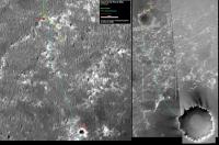
Updated route map.
QUOTE (jamescanvin @ May 26 2006, 08:10 AM)  How wrong is that this time Tesh? I wouldn't call it "wrong" but simply "different". The map may have errors and the different methods to estimate a rover's position too; all those things add to the probability of finding different results. |
|
|
|
|
|
|
May 27 2006, 01:21 AM
Post
#1435
|
|
|
Senior Member Group: Moderator Posts: 2262 Joined: 9-February 04 From: Melbourne - Oz Member No.: 16 |
QUOTE (Tesheiner @ May 26 2006, 07:02 PM) I wouldn't call it "wrong" but simply "different". The map may have errors and the different methods to estimate a rover's position too; all those things add to the probability of finding different results. How diplomatic! 
-------------------- |
|
|
|
|
May 27 2006, 05:03 AM
Post
#1436
|
||||
|
Senior Member Group: Moderator Posts: 2262 Joined: 9-February 04 From: Melbourne - Oz Member No.: 16 |
QUOTE (Castor asked) Can you tell me if it's possible to work out the drive distance from the site drive number? Previously we were at 71A3 and we are now at 71DP. Do the numbers change in a systematic way that is consistent with drive distance? Interesting question. Here is a plot of change in drive number vs drive distance for all the changes in position listed in the tracking database since sol 781 (start of site 68):
I was quite surprised to see there is quite a strong correlation for a lot of the points, i'm guessing that indicates the 'drive so far then check for slippage' parameter. Also note the high black points from recent drives. It looks like they may be driving slightly more aggressively now the ripples arn't so big. Also note all those points with large drive number changes but very small (even zero) drive distances - don't understand that. Zooming in on that graph:
Shows the small changes in drive number which correspond to auto-nav drives. Very little correlation. Note there are even some points with no drive number change but some movement, as well as points with no movement but a number change - now I'm confused!  Moving quickly on. Here is the same plot but with the total distance and drive number change for each sol:
Which is much more sane - giving this (very rough) rule of thumb: For a drive increment of 36 (which is for example xxDx to xxEx etc.) the rover will have moved approximately 6 meters. Of course a change in driving stratagy/aggressiveness could change all this overnight. Here ends this pointless exersice, make driving distance estimates from drive numbers at you peril. James -------------------- |
|||
|
|
|
|||
|
May 27 2006, 06:57 AM
Post
#1437
|
|
|
Founder Group: Chairman Posts: 14431 Joined: 8-February 04 Member No.: 1 |
Thought I'd share this which I wizzed over to Emily last night...
" Right . I started with this http://www.msss.com/mars_images/moc/2004/01/24/ That ellipse is about 87km long, 11km wide Im not sure which ellipse that is ( final targeted ellipse after final TCM, or the launch ellipse it might be worth pinging someone at MER HQ to see if they know exactly where that one came from but its the one we used on the forum ) Going from an estimated centre of that ellipse - the actual landing is, by my maths, 23km downtrack, and 0.4km right of the centre line with the MER entry trajectory coming from the left. Using this http://www.planetary.org/image/oppo-stooke-map.jpg (I cant WAIT for HiRISE imagery) And this http://www.unmannedspaceflight.com/index.p...pe=post&id=4907 I would estimate that the southern edge of the landing ellipse was between 4200 and 4400 metres south of the landing site, and crossed at some point between 760 and 773 Sol 760 Odom was 6682m, sol 773 Odom was 7249m .I wouldnt want to try and drag in either of those sol numbers or distances driven we did our best overlaying that MSSS image ( the larger 10m res one is available at the bottom of the page linked up the top of this email ) onto the route maps that people have done but were not really sure so thats the sort of max range based on what we have. There might be an MER person who knows more accurately." [/size] When you think about it - they got a bit of a downrange distance on both of them due to the atmospheric conditions, but they were both VERY close to centre line which is the real gauge of their accuracy in targetting...400m or so for Opportunity is utterly astonishing. [size="2"]Doug |
|
|
|
|
May 28 2006, 06:04 AM
Post
#1438
|
|
 Senior Member Group: Members Posts: 2228 Joined: 1-December 04 From: Marble Falls, Texas, USA Member No.: 116 |
The Oppster has been really cleaning out the attic in recent updates. In the past, this has signified the commencement of a major advancement campaign. Can we expect a serious attempt to add mileage to the odometer?
-------------------- ...Tom
I'm not a Space Fan, I'm a Space Exploration Enthusiast. |
|
|
|
|
May 28 2006, 08:59 AM
Post
#1439
|
|
 Dublin Correspondent Group: Admin Posts: 1799 Joined: 28-March 05 From: Celbridge, Ireland Member No.: 220 |
QUOTE (djellison @ May 27 2006, 07:57 AM) When you think about it - they got a bit of a downrange distance on both of them due to the atmospheric conditions, but they were both VERY close to centre line which is the real gauge of their accuracy in targetting...400m or so for Opportunity is utterly astonishing. So you could argue that since it was a 456 million km journey they hit the target to a precision of around 1 part in a billion. |
|
|
|
|
May 28 2006, 09:45 AM
Post
#1440
|
|
|
Founder Group: Chairman Posts: 14431 Joined: 8-February 04 Member No.: 1 |
I do a chart in my talks that shows the still of Dan's animation at bridle cut.....400,000,000,000 metres above the airbags, 6.3m below
Doug |
|
|
|
|

|
Lo-Fi Version | Time is now: 16th April 2024 - 12:28 PM |
|
RULES AND GUIDELINES Please read the Forum Rules and Guidelines before posting. IMAGE COPYRIGHT |
OPINIONS AND MODERATION Opinions expressed on UnmannedSpaceflight.com are those of the individual posters and do not necessarily reflect the opinions of UnmannedSpaceflight.com or The Planetary Society. The all-volunteer UnmannedSpaceflight.com moderation team is wholly independent of The Planetary Society. The Planetary Society has no influence over decisions made by the UnmannedSpaceflight.com moderators. |
SUPPORT THE FORUM Unmannedspaceflight.com is funded by the Planetary Society. Please consider supporting our work and many other projects by donating to the Society or becoming a member. |
|