The Top of Vera Rubin Ridge Part 2, Site 67-73, sol 1944-2297, 24 Jan 2018-22 Jan 2019 |

  |
The Top of Vera Rubin Ridge Part 2, Site 67-73, sol 1944-2297, 24 Jan 2018-22 Jan 2019 |
 Jan 31 2018, 12:15 PM Jan 31 2018, 12:15 PM
Post
#16
|
||
 Senior Member  Group: Members Posts: 2428 Joined: 30-January 13 From: Penang, Malaysia. Member No.: 6853 |
The wide exposure variations once again defeated MS ICE on the sol 1950 post drive L-NavCams. I managed to salvage this small section, hopefully it will assist in narrowing down the location until the full version is posted.
|
|
 |
 
|
|
|
Jan 31 2018, 11:03 PM
Post
#17
|
|
 Senior Member Group: Members Posts: 1619 Joined: 12-February 06 From: Bergerac - FR Member No.: 678 |
Don't give up Paul. Maybe try a different stitching software.
Sol 1950 Navcam panoramic. The visibility is so good we can nearly touch the mountains of Gale crater rim ! 
-------------------- |
|
|
|
|
Feb 1 2018, 01:18 AM
Post
#18
|
|
|
Senior Member Group: Members Posts: 2428 Joined: 30-January 13 From: Penang, Malaysia. Member No.: 6853 |
QUOTE (Ant103 @ Feb 1 2018, 07:03 AM)  Don't give up Paul. Maybe try a different stitching software. Beautifully crafted panorama Damia  I do hope that one day I can learn how to use some different software... Thankfully there is always lots of inspiration in this forum I do hope that one day I can learn how to use some different software... Thankfully there is always lots of inspiration in this forum
|
|
|
|
|
Feb 1 2018, 01:22 AM
Post
#19
|
|
 Administrator Group: Admin Posts: 5172 Joined: 4-August 05 From: Pasadena, CA, USA, Earth Member No.: 454 |
QUOTE (PaulH51 @ Jan 31 2018, 04:15 AM) The wide exposure variations once again defeated MS ICE I have sometimes found that I can encourage ICE to work by doing some preliminary exposure adjustment to better match adjacent frames.-------------------- My website - My Patreon - @elakdawalla on Twitter - Please support unmannedspaceflight.com by donating here.
|
|
|
|
|
Feb 1 2018, 01:39 AM
Post
#20
|
|
|
Senior Member Group: Members Posts: 2428 Joined: 30-January 13 From: Penang, Malaysia. Member No.: 6853 |
QUOTE (elakdawalla @ Feb 1 2018, 09:22 AM) I have sometimes found that I can encourage ICE to work by doing some preliminary exposure adjustment to better match adjacent frames. I did try that with this batch, maybe I overdid the lightening of the darker images... More practice needed |
|
|
|
|
Feb 1 2018, 10:56 AM
Post
#21
|
|
|
Senior Member Group: Members Posts: 1619 Joined: 12-February 06 From: Bergerac - FR Member No.: 678 |
Sol 1950 Mastcam34 driving direction pan. Looks like some new features are visibles here.
-------------------- |
|
|
|
|
Feb 1 2018, 06:10 PM
Post
#22
|
||
|
Solar System Cartographer Group: Members Posts: 10151 Joined: 5-April 05 From: Canada Member No.: 227 |
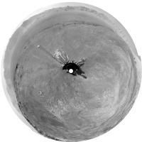
Damia's panorama in circular projection - rover tracks are visible at lower left, on the edge of the dark-floored depression.
Phil
-------------------- ... because the Solar System ain't gonna map itself.
Also to be found posting similar content on https://mastodon.social/@PhilStooke Maps for download (free PD: https://upload.wikimedia.org/wikipedia/comm...Cartography.pdf NOTE: everything created by me which I post on UMSF is considered to be in the public domain (NOT CC, public domain) |
|
|
|
|
|
|
Feb 3 2018, 09:13 PM
Post
#23
|
|
 Member Group: Members Posts: 809 Joined: 3-June 04 From: Brittany, France Member No.: 79 |
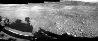
Postcard from Mars: with the particularly low atmospheric opacity these days, we have a crystal-clear view on the distant rim of Gale crater. What a vista!
This is a section of the sol 1950 NavCamR panorama with an extended sky. 
-------------------- |
|
|
|
|
Feb 3 2018, 09:36 PM
Post
#24
|
|
|
Senior Member Group: Members Posts: 3516 Joined: 4-November 05 From: North Wales Member No.: 542 |
A stupendous view indeed. It would be a particularly good one on which to mark the whole route travelled so far. I'm especially enjoying the reminders of earlier parts of the journey, such as the reappearance of the little hill to the east I used to call 'Dumgoyne' now seen from above whereas we were looking up at it from Yellowknife Bay.
|
|
|
|
|
Feb 4 2018, 03:41 PM
Post
#25
|
|
|
Member Group: Members Posts: 809 Joined: 3-June 04 From: Brittany, France Member No.: 79 |
QUOTE (ngunn @ Feb 3 2018, 10:36 PM) A stupendous view indeed. It would be a particularly good one on which to mark the whole route travelled so far. Here it is!  I used the recent JPL Press Release as a reference. I used the recent JPL Press Release as a reference.
-------------------- |
|
|
|
|
Feb 5 2018, 08:37 AM
Post
#26
|
||
|
Senior Member Group: Members Posts: 2428 Joined: 30-January 13 From: Penang, Malaysia. Member No.: 6853 |
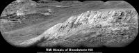
QUOTE (neo56 @ Feb 4 2018, 11:41 PM) Here it is! Very nice Thomas I'm so pleased they named some new features, particularly the large crater in the western rim wall, it's long been a landmark for me to decide where the rover was pointing. I hope they continue to release the names of the vales, gorges and Mesa's etc in the months and years ahead, it makes it so much more enjoyable to follow along and the share the mission with others.Meanwhile on Mars: sol 1955: 5 frame RMI mosaic of 'Bloodstone Hill' (roughly assembled in MS ICE), I guess there could be more images, but this is all they had when I processed these
|
|
|
|
|
|
|
Feb 5 2018, 06:59 PM
Post
#27
|
|
 Member Group: Members Posts: 684 Joined: 24-July 15 Member No.: 7619 |
QUOTE (elakdawalla @ Feb 1 2018, 01:22 AM) I have sometimes found that I can encourage ICE to work by doing some preliminary exposure adjustment to better match adjacent frames. Well, you might try a "suture" - a small image created from the edges of adjacent images, manually matching scale and exposure. This roughly re-creates the "identify 3 match points" that was common in old camera stitch software. |
|
|
|
|
Feb 8 2018, 09:16 AM
Post
#28
|
|
|
Senior Member Group: Members Posts: 2428 Joined: 30-January 13 From: Penang, Malaysia. Member No.: 6853 |
Thanks. I'll see if I can find out more about that 'suture' process
EDIT : No drive on sol 1957, but the rover took another NavCam 360, so I have deleted the roughly stitched pan I posted earlier as it's the same as the one posted on 1950 |
|
|
|
|
Feb 8 2018, 07:17 PM
Post
#29
|
|
|
Member Group: Members Posts: 684 Joined: 24-July 15 Member No.: 7619 |
QUOTE (PaulH51 @ Feb 8 2018, 09:16 AM) Thanks. I'll see if I can find out more about that 'suture' process The other suggestion, see if you can dig up a copy of Canon's Photostitch, circa 2003 that had the incredibly useful ability to set manually forced match points. I've got the .iso somewhere.... |
|
|
|
|
Feb 10 2018, 03:10 AM
Post
#30
|
||
|
Senior Member Group: Members Posts: 2428 Joined: 30-January 13 From: Penang, Malaysia. Member No.: 6853 |
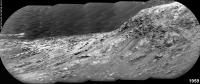
One of the telephoto RMI mosaics from sol 1959, roughly assembled in MS ICE with a little pre stitch processing on some of the frames. The 1959 mission update states that some of these long distance mosaics were checking various steep slopes to look for evidence of grain motion downhill.
|
|
|
|
|
|
|

|
Lo-Fi Version | Time is now: 26th April 2024 - 01:48 PM |
|
RULES AND GUIDELINES Please read the Forum Rules and Guidelines before posting. IMAGE COPYRIGHT |
OPINIONS AND MODERATION Opinions expressed on UnmannedSpaceflight.com are those of the individual posters and do not necessarily reflect the opinions of UnmannedSpaceflight.com or The Planetary Society. The all-volunteer UnmannedSpaceflight.com moderation team is wholly independent of The Planetary Society. The Planetary Society has no influence over decisions made by the UnmannedSpaceflight.com moderators. |
SUPPORT THE FORUM Unmannedspaceflight.com is funded by the Planetary Society. Please consider supporting our work and many other projects by donating to the Society or becoming a member. |
|