Where Is Spirit Right Now? |

  |
Where Is Spirit Right Now? |
 Jul 20 2005, 08:37 PM Jul 20 2005, 08:37 PM
Post
#61
|
|
|
Junior Member  Group: Members Posts: 67 Joined: 18-April 05 From: Austin, Texas Member No.: 249 |
I've taken those contours - generated an elevation map - and came up with these...
http://www.unmannedspaceflight.com/doug_images/elev_1.jpg http://www.unmannedspaceflight.com/doug_images/elev_2.jpg Doug Can anyone identify Spirit's Sol 549 location on these (magnificent) elevation maps posted by Doug? I am having a difficult time estimating distance to summit based on 549 pictures. The summit seems very, very close (10 - 15 meters?), but the distances also seem very deceptive. |
 |
 
|
|
Jul 20 2005, 11:11 PM
Post
#62
|
|
 Senior Member Group: Members Posts: 1887 Joined: 20-November 04 From: Iowa Member No.: 110 |
about where the trough crosses the last contour
|
|
|
|
|
Jul 21 2005, 03:00 AM
Post
#63
|
|
|
Member Group: Members Posts: 123 Joined: 21-February 05 Member No.: 175 |
.
|
|
|
|
|
Jul 21 2005, 07:37 AM
Post
#64
|
|
|
Senior Member Group: Members Posts: 1870 Joined: 20-February 05 Member No.: 174 |
Assuming trafficability on the top of the hill is decent, which I expect it will be, they should drive to the south roll-off and take two panoramas looking south with some tens of meters baseline for long-range stereoscopic analysis. One could be single-filter black and white to save bits. They should then to to the east-northeast flank and do the same looking down across the big bowl to the east of the smaller crater like bowl overlooked by Larry's overlook and then do the same to the east-south-east.
Such multispectral and long-base-line monochrome stereo mosaics would be the single most valuable imaging product of the entire Spirit mission, and would be of crucial value in decyphering the complex and confusing stratigraphy and geology of the hills. |
|
|
|
|
Jul 21 2005, 07:42 AM
Post
#65
|
|
|
Member Group: Members Posts: 156 Joined: 18-March 05 From: Germany Member No.: 211 |
QUOTE (GregM @ Jul 21 2005, 03:00 AM) As I write this, MER-A will be ambling up to the top of the hill in a few hours. The hill will have been climbed and where Spirit is in terms of its long journey that began at the base of West Spur won't be too important any more. They will be at the top of the hill and that  What great news  I can't wait to see those pics! Congratulations to the rover team for this fantastic achievement   Michael |
|
|
|
|
Jul 25 2005, 03:30 PM
Post
#66
|
|
|
Member Group: Members Posts: 236 Joined: 21-June 05 Member No.: 417 |
|
|
|
|
|
Jul 25 2005, 06:26 PM
Post
#67
|
|
|
Member Group: Members Posts: 320 Joined: 19-June 04 Member No.: 85 |
Are those strikes and dips they've added to the traverse map? If so, we're looking at strikes of 180-190 degrees south and dips of 10 to 30 degrees west, which is different from what we saw at Methuselah and Larry's Lookout.
-------------------- |
|
|
|
|
Aug 10 2005, 11:37 AM
Post
#68
|
|
|
Member Group: Members Posts: 236 Joined: 21-June 05 Member No.: 417 |
What is "Li's sol564 loc" ?
http://marsrovers.jpl.nasa.gov/mission/tm-..._A565_3_br2.jpg |
|
|
|
|
Aug 10 2005, 12:10 PM
Post
#69
|
|
 Member Group: Members Posts: 524 Joined: 24-November 04 From: Heraklion, GR. Member No.: 112 |
No idea ....
In the broader map the same spot is identified as "Sol 564 OSU position" http://marsrovers.jpl.nasa.gov/mission/tm-...MERA_A565_2.jpg IIRC, Li is a professor and his lab is doing independent image analysis for JPL. (I remember something like this was mentioned before in this forum, if you search for it you 'll find it.) |
|
|
|
|
Aug 10 2005, 12:38 PM
Post
#70
|
|
|
Member Group: Members Posts: 236 Joined: 21-June 05 Member No.: 417 |
Looks like the calculations by two science teams result in different locations for Spirit.
  http://shoreline.eng.ohio-state.edu/ |
|
|
|
|
Aug 10 2005, 01:09 PM
Post
#71
|
|
|
Member Group: Members Posts: 252 Joined: 27-April 05 Member No.: 365 |
They are probably using the OSU work as a check against their own position estimates. That there is a substantial difference has apparently become noteworthy enough to mark it on the traverse map.
|
|
|
|
|
Aug 10 2005, 02:55 PM
Post
#72
|
||
|
Member Group: Members Posts: 524 Joined: 24-November 04 From: Heraklion, GR. Member No.: 112 |
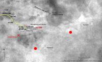
The position of the two summits has also changed considerably compared to the Sol558 map
In the attached image I have marked with red circles the previous summit locations.
Attached thumbnail(s)
|
|
|
|
|
|
|
Aug 10 2005, 03:51 PM
Post
#73
|
|
|
Senior Member Group: Members Posts: 1887 Joined: 20-November 04 From: Iowa Member No.: 110 |
QUOTE (Burmese @ Aug 10 2005, 01:09 PM) They are probably using the OSU work as a check against their own position estimates. That there is a substantial difference has apparently become noteworthy enough to mark it on the traverse map. Been there
|
|
|
|
|
Aug 10 2005, 03:58 PM
Post
#74
|
|
|
Founder Group: Chairman Posts: 14431 Joined: 8-February 04 Member No.: 1 |
I wonder how much the route maps will change once we have a HiRISE image of the place
 Doug |
|
|
|
|
Aug 16 2005, 12:14 AM
Post
#75
|
|
|
Member Group: Members Posts: 129 Joined: 25-March 05 Member No.: 218 |
New Spirit route map out today at JPL (Aug 15)...
Plus, this perspective: http://marsrovers.jpl.nasa.gov/mission/tm-...n_sol149Pan.jpg |
|
|
|
|

|
Lo-Fi Version | Time is now: 22nd April 2024 - 11:17 PM |
|
RULES AND GUIDELINES Please read the Forum Rules and Guidelines before posting. IMAGE COPYRIGHT |
OPINIONS AND MODERATION Opinions expressed on UnmannedSpaceflight.com are those of the individual posters and do not necessarily reflect the opinions of UnmannedSpaceflight.com or The Planetary Society. The all-volunteer UnmannedSpaceflight.com moderation team is wholly independent of The Planetary Society. The Planetary Society has no influence over decisions made by the UnmannedSpaceflight.com moderators. |
SUPPORT THE FORUM Unmannedspaceflight.com is funded by the Planetary Society. Please consider supporting our work and many other projects by donating to the Society or becoming a member. |
|