Rev 141: Titan, distant view after the storm |

  |
Rev 141: Titan, distant view after the storm |
 Mar 3 2011, 11:26 PM Mar 3 2011, 11:26 PM
Post
#31
|
|
 Senior Member  Group: Moderator Posts: 3231 Joined: 11-February 04 From: Tucson, AZ Member No.: 23 |
The stuff about Arrakis Planitia and the October 2004 storm is in a paper now in press over in the journal Icarus:
Shoreline Retreat at Titan’s Ontario Lacus and Arrakis Planitia from Cassini Imaging Science Subsystem Observations E.P. Turtle, J.E. Perry, A.G. Hayes and A.S. McEwen http://dx.doi.org/10.1016/j.icarus.2011.02.005 -------------------- &@^^!% Jim! I'm a geologist, not a physicist!
The Gish Bar Times - A Blog all about Jupiter's Moon Io |
 |
 
|
|
Mar 8 2011, 04:57 AM
Post
#32
|
||
|
Member Group: Members Posts: 699 Joined: 1-April 08 From: Minnesota ! Member No.: 4081 |
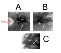
Cassini raw images of Titan from March 5 show the Belet area well. This area showed amazing changes relating to the T72 arrow storm. (see A and B below, images from the Turtle, Perry et al abstract: http://www.lpi.usra.edu/meetings/lpsc2011/pdf/1459.pdf
An enhanced, cropped image from March 5, 2011 (N00168995) is shown in C below. Image C suggests the albedo darkening changes seen in B have reverted considerably back to their appearance before the deluge from the 'arrow' storm.
|
|
|
|
|
|
|
Mar 15 2011, 08:25 PM
Post
#33
|
||
|
Member Group: Members Posts: 699 Joined: 1-April 08 From: Minnesota ! Member No.: 4081 |
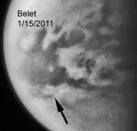
It appears the Belet changes were beginning to revert a bit in the Jan 15 2011 images as well. Below is a composite of CL1 CB3 views from about 995K km.
|
|
|
|
|
|
|
Mar 17 2011, 06:00 PM
Post
#34
|
|
|
Senior Member Group: Moderator Posts: 3231 Joined: 11-February 04 From: Tucson, AZ Member No.: 23 |
Titanicriver kinda let the cat out of the bag a week early, but that's okay. I'm stunned it took THAT long. Anyways...
Cassini Sees Seasonal Rains Transform Titan's Surface http://www.ciclops.org/view/6744/ Image Releases are at: http://www.ciclops.org/view_event/155/Meth..._Titans_Deserts That's the press release for our paper now published in Science regarding the late September/October arrow storm and equatorial cloud breakout and subsequent surface change. We saw a substantial area along the southern boundary of Belet darken as a result of these storms in October, as well as smaller areas near the southern boundary of Senkyo (first spotted in December) and in southwestern Adiri. More recently, as the "waters" have receded (or simply dried up), patches of brighter material have been spotted. We are still trying to figure out the best explanation for this, but one likely one is that the rains have cleaned off "gunk" off portions of Titan's surface, revealing brighter material beneath the...ummm....gunk (not a scientific term I know, but it is easier to say than unidentified hydrocarbon surficial material). For those who have access to Science you can find our paper at: http://www.sciencemag.org/content/331/6023/1414 . If you don't have access, send me a pm with your email addy and I will send a copy along to you. I just need to download the reprint myself first  In addition to publicizing findings from these last few exciting months, we are also announcing findings from our cloud monitoring campaign during the extended mission that ended, coincidentally enough with the observation of the arrow storm. These observations included what we call "caboose" observations, cloud tracking periods added on in the 2-3 days before or after a Titan flyby. These allowed us to capture movies of clouds going around the north pole of Titan as well as a set of streaks at the moon's southern mid-latitudes back in December 2009. These movies are now posted on the CICLOPS website. The original paper was published in GRL here: http://www.agu.org/pubs/crossref/2011/2010GL046266.shtml Unfortunately, I don't have institutional access to GRL, so if anyone does, and can send it to me, then I can email it to anyone who requests that one. Note: I now the GRL paper (actually I had it all along, but I thought it was a draft version...). So if you want that one too, let me know. -------------------- &@^^!% Jim! I'm a geologist, not a physicist!
The Gish Bar Times - A Blog all about Jupiter's Moon Io |
|
|
|
|
Mar 18 2011, 03:07 AM
Post
#35
|
|
 Member Group: Members Posts: 610 Joined: 23-February 07 From: Occasionally in Columbia, MD Member No.: 1764 |
QUOTE (volcanopele @ Mar 17 2011, 01:00 PM)  Image Releases are at: http://www.ciclops.org/view_event/155/Meth..._Titans_Deserts I had the JSC Earth Observation Lab dig out and scan that last image, which I found initially in a Bulletin of the American Meteorological Soc. paper.... Gemini 4 was the first US manned mission over 1 day - as well as Ed White's famous spacewalk, there was also an Earth imaging experiment, using the 70mm Hasselblad camera with an 80mm lens, which caught the first good spaceborne image of sand dunes (if I am not wrong) as well as various cloud and landscape images including this one. An analysis in the literature shortly after the flight showed the dark streak saw about 2 inches of rainfall, whereas the undarkened area had less than 0.25 inch. I'd be interested if people know of examples of this effect since (seems like these dark streaks should be observed a lot...?) |
|
|
|
|
Mar 18 2011, 06:36 PM
Post
#36
|
|
|
Merciless Robot Group: Admin Posts: 8783 Joined: 8-December 05 From: Los Angeles Member No.: 602 |
Ralph, do you mean examples from orbital imagery alone? I suspect that this phenomenon is so subtle at local scales that it is not obvious from any other perspective.
-------------------- A few will take this knowledge and use this power of a dream realized as a force for change, an impetus for further discovery to make less ancient dreams real.
|
|
|
|
|
Mar 18 2011, 06:52 PM
Post
#37
|
|
|
Senior Member Group: Members Posts: 1582 Joined: 14-October 05 From: Vermont Member No.: 530 |
Do you want wet, or inundated? Inundated, I'd look for satellite imagery of Lençóis Maranhenses National Park. High local water table under dune fields, seasonal rains.
Or Indian monsoons: http://earthobservatory.nasa.gov/IOTD/view.php?id=3856 |
|
|
|
|
Mar 19 2011, 02:07 PM
Post
#38
|
|
|
Member Group: Members Posts: 610 Joined: 23-February 07 From: Occasionally in Columbia, MD Member No.: 1764 |
QUOTE (stevesliva @ Mar 18 2011, 01:52 PM) Do you want wet, or inundated? Inundated, I'd look for satellite imagery of Lençóis Maranhenses National Park. High local water table under dune fields, seasonal rains. Nprev - I mean orbital (well, not strictly - I'd accept images from interplanetary space! Or even sounding rocket) Stevesliva - I mean damp/wet, NOT inundated. Plenty of remote sensing of flooding. I mean darkened by being damp, as one often sees at the small scale on sidewalks or on the beach or on playas. Because the Titan darkening occurs not only in depressions, it does not seem to be inundation... |
|
|
|
|
Mar 19 2011, 07:00 PM
Post
#39
|
|
|
Senior Member Group: Members Posts: 1582 Joined: 14-October 05 From: Vermont Member No.: 530 |
Swath seems to be a good keyword, but there's not so much in the way of rain swaths. Snow swaths, hail swaths, tornado swaths, etc are much more common.
http://www.spc.noaa.gov/coolimg/coolrain/index.html http://cimss.ssec.wisc.edu/goes/blog/wp-co...H010207_RGB.JPG from http://cimss.ssec.wisc.edu/goes/blog/archi.../2007/06/page/2 http://cimss.ssec.wisc.edu/goes/blog/categ...y-rain-flooding (mentions swaths of wet ground not visible in visible wavelengths) |
|
|
|
|
Mar 19 2011, 07:48 PM
Post
#40
|
|
|
Merciless Robot Group: Admin Posts: 8783 Joined: 8-December 05 From: Los Angeles Member No.: 602 |
Dig it, Ralph; merely a clarifying question. I suspect that many examples may be found, particularly in the GOES image set.
-------------------- A few will take this knowledge and use this power of a dream realized as a force for change, an impetus for further discovery to make less ancient dreams real.
|
|
|
|
|
Mar 19 2011, 11:20 PM
Post
#41
|
|
|
Member Group: Members Posts: 610 Joined: 23-February 07 From: Occasionally in Columbia, MD Member No.: 1764 |
QUOTE (nprev @ Mar 19 2011, 02:48 PM) Dig it, Ralph; merely a clarifying question. I suspect that many examples may be found, particularly in the GOES image set. Well, yes. But I'd prefer not to have to search myself - I wondered if annotated examples exist from GOES/Meteosat much like Steve's last example (but at shorter wavelengths) If it doesnt exist, maybe some prof out there can set up a hunt as a student project.... |
|
|
|
|
Mar 20 2011, 04:04 AM
Post
#42
|
|
 Senior Member Group: Moderator Posts: 2785 Joined: 10-November 06 From: Pasadena, CA Member No.: 1345 |
Here's a link to an animated GIF that shows the flooding and evaporation of Lake Poopo, Bolivia over the course of a year. This uses GOES-E images.
http://www.flickr.com/photos/31678681@N07/5541410235/ -------------------- Some higher resolution images available at my photostream: http://www.flickr.com/photos/31678681@N07/
|
|
|
|
|
Mar 20 2011, 07:07 PM
Post
#43
|
||
|
Member Group: Members Posts: 699 Joined: 1-April 08 From: Minnesota ! Member No.: 4081 |
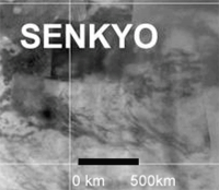
Painting a broad view of the Arrow Storm changes including those in Belet (as just beautifully published in Science) and those in S Senkyo (brighter areas noted in the Science supplement, darker areas not). The arrow storm was presumably made up of numerous individual cells and might be better thought of as an equivalent of an intense low pressure system on earth.
|
|
|
|
|
|
|
Mar 22 2011, 11:34 AM
Post
#44
|
|
|
Member Group: Members Posts: 610 Joined: 23-February 07 From: Occasionally in Columbia, MD Member No.: 1764 |
QUOTE (Juramike @ Mar 19 2011, 11:04 PM) Here's a link to an animated GIF that shows the flooding and evaporation of Lake Poopo, Bolivia Cool, thanks, Mike. A lot going on there. And 'Lake Poopo' - someone *HAS* to propose that to the IAU for a Titan feature...... |
|
|
|
|
Mar 23 2011, 11:22 AM
Post
#45
|
||
|
Member Group: Members Posts: 699 Joined: 1-April 08 From: Minnesota ! Member No.: 4081 |
To quote VP in post #34 above ... 'but one likely one is that the rains have cleaned off "gunk" off portions of Titan's surface, revealing brighter material beneath the...ummm....gunk' ...
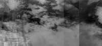
The S Senkyo area may be a good example of what VP is suggesting. A S Senkyo topography map (color swaths from Zebker and Stiles et al http://www.sciencemag.org/content/324/5929/921.full), while far from complete did interestingly enough include a swath near the area of bright and dark change as seen in the Dec 20th ISS image. There's a slight bump in part of the bright outer rim suggesting its higher and making a case for a whitening of a topographic high washing darker 'gunk' downslope into a relatively lower basin. The figure below shows the basemap and then Dec 20 image and finally the SAR altimetry swaths. The arrow points at the possible higher terrain. The whole area was directly under the Arrow Storm.
|
|
|
|
|
|
|

|
Lo-Fi Version | Time is now: 19th April 2024 - 09:37 PM |
|
RULES AND GUIDELINES Please read the Forum Rules and Guidelines before posting. IMAGE COPYRIGHT |
OPINIONS AND MODERATION Opinions expressed on UnmannedSpaceflight.com are those of the individual posters and do not necessarily reflect the opinions of UnmannedSpaceflight.com or The Planetary Society. The all-volunteer UnmannedSpaceflight.com moderation team is wholly independent of The Planetary Society. The Planetary Society has no influence over decisions made by the UnmannedSpaceflight.com moderators. |
SUPPORT THE FORUM Unmannedspaceflight.com is funded by the Planetary Society. Please consider supporting our work and many other projects by donating to the Society or becoming a member. |
|