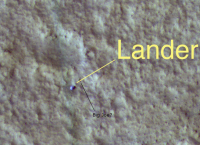
Viking 1 & 2 landers from HiRISE, Landers definitively spotted |

  |
Viking 1 & 2 landers from HiRISE, Landers definitively spotted |
 Dec 5 2006, 01:36 AM Dec 5 2006, 01:36 AM
Post
#16
|
|
|
Solar System Cartographer  Group: Members Posts: 10146 Joined: 5-April 05 From: Canada Member No.: 227 |
I don't have the maps in front of me but it was maybe 10 km southeast of the true site.
Of course, all these early attempts (Morris and Jones, then the botched job I did, and then Tim's successful find) were not identifying the lander itself, they were triangulating the lander location based on the pattern of ridges (mostly crater rims) around the lander. The best Viking mosaic was about 8 m/pixel and very low contrast. My result is in an LPSC abstract from about 1998. Phil -------------------- ... because the Solar System ain't gonna map itself.
Also to be found posting similar content on https://mastodon.social/@PhilStooke NOTE: everything created by me which I post on UMSF is considered to be in the public domain (NOT CC, public domain) |
 |
 
|
|
Dec 5 2006, 01:54 AM
Post
#17
|
|
|
Solar System Cartographer Group: Members Posts: 10146 Joined: 5-April 05 From: Canada Member No.: 227 |
I should add this, too... it looks like MSSS were absolutely correct in their Viking 2 identification, except that they found the backshell instead of the lander.
Phil -------------------- ... because the Solar System ain't gonna map itself.
Also to be found posting similar content on https://mastodon.social/@PhilStooke NOTE: everything created by me which I post on UMSF is considered to be in the public domain (NOT CC, public domain) |
|
|
|
|
Dec 5 2006, 05:29 AM
Post
#18
|
|
|
Member Group: Members Posts: 428 Joined: 21-August 06 From: Northern Virginia Member No.: 1062 |
QUOTE (Phil Stooke @ Dec 4 2006, 06:54 PM)  I should add this, too... it looks like MSSS were absolutely correct in their Viking 2 identification, except that they found the backshell instead of the lander. Phil Ahh, the backshell. I was wondering what that was... That makes absolute sense now, it hadn't beforehand. For some reason I thought there was only two parts to the Vikings, and I guess there was 3. Oh well. |
|
|
|
|
Dec 5 2006, 05:44 AM
Post
#19
|
|
|
Member Group: Senior Member Posts: 136 Joined: 8-August 06 Member No.: 1022 |
QUOTE (AlexBlackwell @ Dec 4 2006, 05:30 PM) Phil: I haven't checked but do you happen to know how close Morris and Jones [1980] got with their VL1 estimate? I believe it was just under 6 km west southwest of the actual location. Crater "A" was mischosen. It was because I could see boulders on its rim, and knew what they looked like relative to the larger "Big Crater" at MPF that made me first realize that the crater on the VL-1 horizon couldn't be that big, because the boulders would have been absurdly large by comparison. Once I realized that, it took little time to find a better match to the horizon vecots. -Tim. |
|
|
|
|
Dec 5 2006, 08:35 AM
Post
#20
|
||
 Senior Member Group: Members Posts: 1619 Joined: 12-February 06 From: Bergerac - FR Member No.: 678 |
Incredible! It's simply incredible! 30 years after, we meet one time again the landers!
 Congratulation for everybody  It think that I found Big Joe, no?
-------------------- |
|
|
|
|
|
|
Dec 5 2006, 09:20 AM
Post
#21
|
|
 Lord Of The Uranian Rings Group: Members Posts: 798 Joined: 18-July 05 From: Plymouth, UK Member No.: 437 |
QUOTE (Ant103 @ Dec 5 2006, 08:35 AM) It think that I found Big Joe, no? Also called: "The Rock Formerly Known as 'Big Bertha'".  These are really great images - my congratulations to everbody involved with HiRISE and MRO. Ian. -------------------- |
|
|
|
|
Dec 5 2006, 10:47 AM
Post
#22
|
|
|
Rover Driver Group: Members Posts: 1015 Joined: 4-March 04 Member No.: 47 |
did anyone comment yet on how amazing this all is? oh yes, they did....
Really thrilled and excited about all this. We really live in a good time for space exploration! |
|
|
|
| Guest_Myran_* |
Dec 5 2006, 12:28 PM
Post
#23
|
|
Guests |
QUOTE Ant103 wrote: It think that I found Big Joe, no? Yes it seems quite likely you spotted the rock in question. I remember from published comments of that day that they felt lucky that the Viking lander hadnt ended up on top of that rock and crashed or flipped over. But yes remcook, its amazing, like seeing old friends after a very long time.
|
|
|
|
|
Dec 5 2006, 02:18 PM
Post
#24
|
|
|
Member Group: Members Posts: 212 Joined: 19-July 05 Member No.: 442 |
It's wonderful to see the landscapes that I gazed at in books during the 1980's from above, a fitting reward for the long years of waiting. Let's hope the bean counters don't spoil the party...
|
|
|
|
|
Dec 5 2006, 04:14 PM
Post
#25
|
|
|
Senior Member Group: Members Posts: 1619 Joined: 12-February 06 From: Bergerac - FR Member No.: 678 |
Here is a more color-realistic view based on the hirise picture
 (1,1 Mo) (1,1 Mo)
-------------------- |
|
|
|
| Guest_AlexBlackwell_* |
Dec 5 2006, 04:23 PM
Post
#26
|
|
Guests |
QUOTE (tim53 @ Dec 4 2006, 07:44 PM) I believe it was just under 6 km west southwest of the actual location. Crater "A" was mischosen. It was because I could see boulders on its rim, and knew what they looked like relative to the larger "Big Crater" at MPF that made me first realize that the crater on the VL-1 horizon couldn't be that big, because the boulders would have been absurdly large by comparison. Once I realized that, it took little time to find a better match to the horizon vecots. Thanks, Tim (and to Phil above). It'll be interesting to see a composite map with the various Viking lander (and MPF, when available from HiRISE) position estimates, which would help illustrate how the Mars control net has evolved and improved over the decades. This post has been edited by AlexBlackwell: Dec 5 2006, 05:31 PM |
|
|
|
| Guest_PhilCo126_* |
Dec 5 2006, 05:30 PM
Post
#27
|
|
Guests |
This certainly brings back some memories when I was writing to almost each of the NASA centers as a 10-year old and was amazed to get photos back from Dr Gentry LEE, Dr Jerry SOFFEN, Dr Edward Stone, Dr Charles HALL etc...
 
|
|
|
|
|
Dec 5 2006, 11:24 PM
Post
#28
|
|
 Senior Member Group: Members Posts: 3419 Joined: 9-February 04 From: Minneapolis, MN, USA Member No.: 15 |
QUOTE (Ant103 @ Dec 5 2006, 11:14 AM) Here is a more color-realistic view based on the hirise picture (1,1 Mo)Wow! This view of the landscape is absolutely incredible. I've run out of superlatives -- I'm reminded of John Young, standing on the Moon, using the word 'spectacular' for the fourth time in five minutes, and then apologizing, saying you just run out of words... From a geologic point of view, this image shows quite well that the boulder populations are concentrated on the floors and rims of depressions, but with a strong bias towards the west-northwest inner rims and east-southeast outer ramparts. This seems to match one of the two predominant sets of lineations; one set runs nearly horizontal through the scene, dipping only slightly to the south as it moves to the east, and seems to be composed mostly of dune, ripple and other aeolian features. The other set, which seems to align with the positioning bias of the boulder population, runs from east-southeast to west-northwest. (*) These lineations are rougher and expressed in larger features, the apparent sculpting of what now looks like a "scoured" terrain that, prior to the scouring event(s), featured a lot of 10- to 20-m craters. Seeing as how the Chryse region was selected as a landing site because it's located in the midst of an apparent ancient catastrophic outflow channel, I guess you'd expect to see signs of directional scouring in the basic landforms. It looks to me like many of the boulders were deposited preferentially in the "downstream" sides of craters. This image is, to me, far more compelling evidence of ancient catastrophic floods in the region than anything we actually saw from the surface. * - All of the above directions assume that north is up in the image; I'm using them relative to this image only, and don't intend to convey that north is indeed straight up throughout the image. -the other Doug -------------------- The trouble ain't that there is too many fools, but that the lightning ain't distributed right. -Mark Twain
|
|
|
|
|
Dec 6 2006, 06:41 AM
Post
#29
|
|
 The Poet Dude Group: Moderator Posts: 5551 Joined: 15-March 04 From: Kendal, Cumbria, UK Member No.: 60 |
Ant,
A very sincere thanks to you for posting that image. As it clearly has done for others here, it brought images flooding back for me. One of my first "encounters" with Mars, and probably what really fired up my passion for the planet, was coming across a National Geographic on a shelf in my art class at school (a great stack of old issues were kept there as reference material - great if you needed to know what African women with rings around their necks, or salmon leaping up streams looked like!). One day, probably when I should have been doing something else, I came across one of the issues showcasing images from the Vikings... wow, love at first sight! I must admit I sneaked the mag out of class and took it home where I drooled over those pictures again and again... it's still sat on my shelf over there, next to the Pathfinder 3D images issue... So, seeing that colourised pic sent a real shiver through me. Thanks! 
-------------------- |
|
|
|
|
Dec 6 2006, 09:12 AM
Post
#30
|
|
|
Member Group: Members Posts: 100 Joined: 11-October 04 From: Oxford, UK (Glasgow by birth) Member No.: 101 |
The BBC have picked up on these fantastic images: http://news.bbc.co.uk/1/hi/sci/tech/6211870.stm Brian -------------------- "There are 10 types of people in the world - those who understand binary code, and those who don't."
|
|
|
|
|

|
Lo-Fi Version | Time is now: 19th April 2024 - 12:10 AM |
|
RULES AND GUIDELINES Please read the Forum Rules and Guidelines before posting. IMAGE COPYRIGHT |
OPINIONS AND MODERATION Opinions expressed on UnmannedSpaceflight.com are those of the individual posters and do not necessarily reflect the opinions of UnmannedSpaceflight.com or The Planetary Society. The all-volunteer UnmannedSpaceflight.com moderation team is wholly independent of The Planetary Society. The Planetary Society has no influence over decisions made by the UnmannedSpaceflight.com moderators. |
SUPPORT THE FORUM Unmannedspaceflight.com is funded by the Planetary Society. Please consider supporting our work and many other projects by donating to the Society or becoming a member. |
|