First public release of Kaguya data |

  |
First public release of Kaguya data |
 Nov 3 2009, 01:50 AM Nov 3 2009, 01:50 AM
Post
#16
|
|
|
Solar System Cartographer  Group: Members Posts: 10151 Joined: 5-April 05 From: Canada Member No.: 227 |
IMG2PNG can't do it as it is. The problem might be the header, but I'm not sure. A solution along these lines would be great. Any unzip-type app will extract the IMG file from the downloaded file, but I can't get anything else to open the IMG.
Phil -------------------- ... because the Solar System ain't gonna map itself.
Also to be found posting similar content on https://mastodon.social/@PhilStooke Maps for download (free PD: https://upload.wikimedia.org/wikipedia/comm...Cartography.pdf NOTE: everything created by me which I post on UMSF is considered to be in the public domain (NOT CC, public domain) |
 |
 
|
|
Nov 3 2009, 08:57 AM
Post
#17
|
|
|
Founder Group: Chairman Posts: 14432 Joined: 8-February 04 Member No.: 1 |
The best analogy I can come up with is the values in HRSC Dems - which a guy on HRSC kindly wrote an IDL routine to churn into something usefull
QUOTE hrsc2tif A tool to convert HRSC PDS- or VICAR-format files to TIFF format. For DTMs, the 16-bit signed integers are converted to 16-bit unsigned integers by adding 32768. Limitation: only converts files small enough to be read into RAM. The software requires installation of the free IDL virtual machine, and runs on all common platforms. This data set is in km if i remember, so it would need to be multiplied by 1000 first - than then have the negative value of the lowest negative altitude added (i.e. if the lowest is -1580 metres, add 1580 to make them all positive values starting at 0) To be honest, just a raw array of values normally can be convinced to work with ImageJ or Photoshop. |
|
|
|
|
Nov 3 2009, 09:32 AM
Post
#18
|
|
|
Member Group: Members Posts: 890 Joined: 18-November 08 Member No.: 4489 |
i just looked at LALT_GGT_NUM.TAB in ghex edit
see screen shot [attachment=19510:Screenshot.png] on the right -- the 3 columns top one CODE 89.96875 0.040 0.09375 is looking like excel is going to get puled out i will need to pull the middle value first is lat. second is the gray value and the third is the long. |
|
|
|
|
Nov 3 2009, 10:25 AM
Post
#19
|
|
|
Founder Group: Chairman Posts: 14432 Joined: 8-February 04 Member No.: 1 |
As text loaded straight into ImageJ - it's lat long alt - there's a header that describes it once unzipped (I used 7zip) - you may have it muddled somewhere.
|
|
|
|
|
Nov 3 2009, 06:48 PM
Post
#20
|
||
|
Founder Group: Chairman Posts: 14432 Joined: 8-February 04 Member No.: 1 |
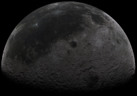
Thanks to mhoward's processing and my running it through ImageJ - we have a 16bit Tif for those that like such things. It looks like the attached 1/4 size JPG and is found HERE - About 26 meg
Attached thumbnail(s)
|
|
|
|
|
|
|
Nov 3 2009, 07:05 PM
Post
#21
|
||
 Senior Member Group: Moderator Posts: 3431 Joined: 11-August 04 From: USA Member No.: 98 |
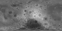
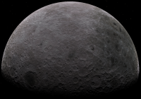
Also, something we've been waiting for for a long time: a proper surface normal map for the Moon.
LALT surface normal map (22MB PNG) enhanced LALT surface normal map (26MB PNG) The first version is technically accurate AFAIK; the second is "enhanced" a bit (the normal vector x and y are magnified somewhat). Use whichever one works best. Attached is a quarter-sized version of the enhanced model.
Attached thumbnail(s)
|
|
|
|
|
|
|
Nov 3 2009, 07:09 PM
Post
#22
|
|||||
 Senior Member Group: Moderator Posts: 3232 Joined: 11-February 04 From: Tucson, AZ Member No.: 23 |
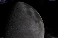
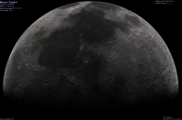
These Celestia screenshots use mhoward's regular normal map:
-------------------- &@^^!% Jim! I'm a geologist, not a physicist!
The Gish Bar Times - A Blog all about Jupiter's Moon Io |
||||
|
|
|
||||
|
Nov 3 2009, 07:24 PM
Post
#23
|
||
|
Senior Member Group: Moderator Posts: 3431 Joined: 11-August 04 From: USA Member No.: 98 |
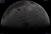
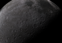
My cellphone probably can't compete with stuff rendered on a full-blown computer, but an experimental version of my Moon Globe app looks better using this data, too.
Attached thumbnail(s)
|
|
|
|
|
|
|
Nov 3 2009, 07:27 PM
Post
#24
|
|
|
Member Group: Members Posts: 890 Joined: 18-November 08 Member No.: 4489 |
for celestia you might want to run the 16bit tiff through nms to make a spherical corrected normal map
|
|
|
|
|
Nov 3 2009, 07:39 PM
Post
#25
|
|
|
Senior Member Group: Moderator Posts: 3431 Joined: 11-August 04 From: USA Member No.: 98 |
QUOTE (JohnVV @ Nov 3 2009, 12:27 PM)  for celestia you might want to run the 16bit tiff through nms to make a spherical corrected normal map If somebody does that, I'd be curious to know if the result is different from mine. I'm glad to know about those tools, but I don't have time to look into them further now. |
|
|
|
|
Nov 3 2009, 07:44 PM
Post
#26
|
|
|
Senior Member Group: Moderator Posts: 3431 Joined: 11-August 04 From: USA Member No.: 98 |
P.S. If anybody prefers raw 16-bit binary integer data over the 16-bit TIFF file, I've got that - just
|
|
|
|
|
Nov 3 2009, 07:48 PM
Post
#27
|
|
|
Junior Member Group: Members Posts: 35 Joined: 28-September 05 From: Seattle, WA Member No.: 514 |
QUOTE (mhoward @ Nov 3 2009, 11:39 AM) If somebody does that, I'd be curious to know if the result is different from mine. I'm glad to know about those tools, but I don't have time to look into them further now. nms (Normal Map Spherical) just applies a correction for the spherical geometry of a planet. The slope in x is increased by a factor of (1/cos(latitude)) to account for the fact that the map is horizontally compressed near the poles. If you wrote a tool especially to make normal maps for planets, it may already be doing this. If not, it's an easy correction to include. --Chris |
|
|
|
|
Nov 3 2009, 07:50 PM
Post
#28
|
|
|
Junior Member Group: Members Posts: 35 Joined: 28-September 05 From: Seattle, WA Member No.: 514 |
QUOTE (djellison @ Nov 3 2009, 10:48 AM) Thanks to mhoward's processing and my running it through ImageJ - we have a 16bit Tif for those that like such things. Thanks for producing this! What heights to the minimum and maximum pixel values represent in this tiff? EDIT: Probably a dumb question. After opening the zip, I see that the pixel units are apparently meters. --Chris |
|
|
|
|
Nov 3 2009, 07:56 PM
Post
#29
|
|
|
Senior Member Group: Moderator Posts: 3431 Joined: 11-August 04 From: USA Member No.: 98 |
Thanks, Chris. I've got the sine of the latitude in my math, so I think I'm doing the same thing, maybe in a slightly different way. Still would be curious to know if the result comes out exactly the same.
|
|
|
|
|
Nov 3 2009, 09:25 PM
Post
#30
|
|
|
Senior Member Group: Moderator Posts: 3232 Joined: 11-February 04 From: Tucson, AZ Member No.: 23 |
-------------------- &@^^!% Jim! I'm a geologist, not a physicist!
The Gish Bar Times - A Blog all about Jupiter's Moon Io |
|
|
|
|

|
Lo-Fi Version | Time is now: 24th April 2024 - 10:57 PM |
|
RULES AND GUIDELINES Please read the Forum Rules and Guidelines before posting. IMAGE COPYRIGHT |
OPINIONS AND MODERATION Opinions expressed on UnmannedSpaceflight.com are those of the individual posters and do not necessarily reflect the opinions of UnmannedSpaceflight.com or The Planetary Society. The all-volunteer UnmannedSpaceflight.com moderation team is wholly independent of The Planetary Society. The Planetary Society has no influence over decisions made by the UnmannedSpaceflight.com moderators. |
SUPPORT THE FORUM Unmannedspaceflight.com is funded by the Planetary Society. Please consider supporting our work and many other projects by donating to the Society or becoming a member. |
|