The Mountains of Titan, Recent article in Icarus |

The Mountains of Titan, Recent article in Icarus |
 Aug 13 2007, 06:46 PM Aug 13 2007, 06:46 PM
Post
#1
|
|
 Senior Member  Group: Moderator Posts: 2785 Joined: 10-November 06 From: Pasadena, CA Member No.: 1345 |
Recently released article on RADAR interpretations of Titan's mountains.
"Mountains of Titan observed by Cassini Radar" J. Radebaugh, R. Lorenz, R. Kirk, J. Lunine, E.R. Stofan, R. Lopes, S. Wall Icarus (2007) doi:10.1016/j.icarus.2007.06.020 [Only accessible via Icarus website? I have no clue how to link to a free abstract. Sorry, y'all!] This is the full paper following the 2006 LPS abstract (which is freely available): Radebaugh et al LPS 37 (2006) Abstract 1007. Mountains on Titan Observed by Cassini Radar. Abstract freely available here. -Mike -------------------- Some higher resolution images available at my photostream: http://www.flickr.com/photos/31678681@N07/
|
 |
 
|
 |
|
Aug 14 2007, 12:08 AM
Post
#2
|
|
|
Member Group: Members Posts: 813 Joined: 29-December 05 From: NE Oh, USA Member No.: 627 |
Mike...
Evocative name for a thread. Hope there will soon be some meaty posts. I do not think any of the radar passes have swept the presumed "mountains" that streach below Senkyo. http://photojournal.jpl.nasa.gov/catalog/PIA09032 The VIMS team seem confidant these are mountains and not albedo patches, but we really do not know. Perhaps future passes will help pin this down? Emily on TPS Cassini Radar page notes that T39 in December is a radar pass and I believe that is a south polar pass but not sure of the longitude. Craig |
|
|
|
|
Aug 14 2007, 02:06 AM
Post
#3
|
|
 Administrator Group: Admin Posts: 5172 Joined: 4-August 05 From: Pasadena, CA, USA, Earth Member No.: 454 |
I haven't gotten my hands on a copy of the paper yet, but I had a brief chat with Jani today she told me they're confident of mountains in Xanadu above 1 km, and possibly even 2 km; and even the mountains in the lakes region near the north pole may be that high. This is nothing compared to mountains 13 km tall on Io, of course, but those are made of rock; it's not very easy to maintain ice mountains 2 km tall over geologic time scales, so that's very interesting...
--Emily -------------------- My website - My Patreon - @elakdawalla on Twitter - Please support unmannedspaceflight.com by donating here.
|
|
|
|
|
Aug 14 2007, 09:12 AM
Post
#4
|
|
|
Rover Driver Group: Members Posts: 1015 Joined: 4-March 04 Member No.: 47 |
This article is still in press and so it will take a while before there will be a separate link to the abstract. so it's not you mike
 BTW: There's a nice article above that for VP (some great Io images with Keck) |
|
|
|
|
Aug 15 2007, 02:07 AM
Post
#5
|
|
 Member Group: Members Posts: 809 Joined: 11-March 04 Member No.: 56 |
Is it more likely that these mountains overlay a higher rocky terrain, or that some kind of tectonic activity is contributing to ongoing orogeny?
|
|
|
|
|
Sep 17 2007, 07:53 PM
Post
#6
|
|||
|
Senior Member Group: Moderator Posts: 2785 Joined: 10-November 06 From: Pasadena, CA Member No.: 1345 |
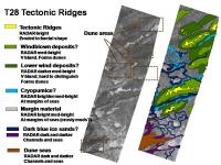
I took a section of the N Fensal RADAR mosaic that shows a really nice tectonic ridge and deposition layer sequence. This is in the T28 RADAR Swath and is located at [33N, 20W] in the part of N Fensal Sand Sea Basin that is transitioning into the Temperate Bland Zone.
Happily, the W edge of the T28 RADAR swath seems to be right along the boundary of the Sand Sea, as evidenced by the RADAR dark (v. smooth) parts along the W edge of the swath. In some sections of the edge, "typical" dune sands can be seen. This same section also shows exposed tectonic ridge tops, evidence by the RADAR bright thin highly fractal looking (eroded) details. So in this section of T28 we can see a nice cross section of Titan from the ridge tops down to the flats of the Sand Sea basin. I attempted to work out the sequence from ridge tops (yellow in the figure), through lower layers (green), to the uniform bland (uncolored medium RADAR gray) and into the smoother river and sea deposits (dark blue and purple shades). Some RADAR-brighter areas that did not show obvious fine fractal-like details were also left uncolored.
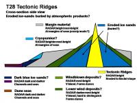
The first graphic shows a colorized RADAR image, and the second graphic shows a hypothetical cross section. [The subtle RADAR details are probably easier to see from PIA09217]. A few interesting observations: * The tectonic ridges are very regularly spaced. * The lower deposits seem to follow a very regular pattern: ridge tops (yellow)-->RADAR med bright (light green)-->RADAR darker med bright (darker green)-->bland margin (uncolored)-->stream and bays (dark blue and purple). * The windblown deposits (greens) form dunes. These dunes seem smaller and seem to have a different aspect than the Equatorial dune sea dunes. (Brown squares indicate dune fields). Streams follow tectonic valleys. * Streams seem to meander all over in the bland margin areas. This pattern resembles muddy sloughs more than a tumbling mountain stream. The streambeds are all dark. Bright streambeds are not visible in this area. * There are some RADAR-bright deposits that seem to be located at the margin of streams. Could this be cryopumice or crusty zone materials? It is not clear if the different RADAR brightness in the uncolored gray/green zone is due to different materials or different textures. It is entirely possible that there is a layer of atmospheric deposition products that have washed out and wind-sorted themselves between the ridges. -Mike -------------------- Some higher resolution images available at my photostream: http://www.flickr.com/photos/31678681@N07/
|
||
|
|
|
||
|
Sep 17 2007, 10:49 PM
Post
#7
|
|||||||||||
|
Senior Member Group: Moderator Posts: 2785 Joined: 10-November 06 From: Pasadena, CA Member No.: 1345 |
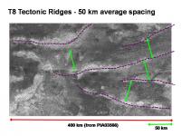
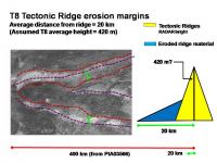
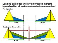
In the article, Radebaugh et al describes tectonic ridges in the Belet Equatorial Sand Sea as seen from the T8 RADAR swath. The ridges in T8 have a mean height of 420 m. The ridges are also typically surrounded by radar-bright diffuse blankets of material, often to several tens of kilometers from the mountain base. These are materials that have perhaps been eroded off the mountain and then deposited in a gently sloping mantle that becomes thinner with greater radial distance. The blankets to not appear to have substantial topography or raised edges, so we consider theslopes of the blankets to be 2 degrees or less.
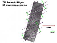
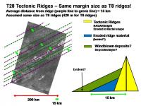
As seen from the graphic above, the T8 tectonic ridges are spaced sorta regularly about 50 km apart. In the next graphic, the T28 tectonic ridges are spaced very regularly about 60 km apart.
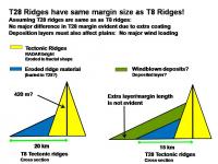
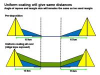
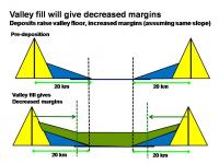
The margins in the T8 tectonic ridges extend approximately 20 km from the ridges. The margins in the T28 tectonic ridges are spaced very nicely and extend about 15 km from the ridge center. The margin is considered to be the border of the RADAR medium dark material (green in post above) with the RADAR medium light material (uncolored in the post above). Like the tectonic ridges, in the T28 swath the margins are regularly spaced. Assuming the tectonic ridges have similar heights and other characteristics, we would expect a similar mantle of material to have eroded from the ridge. If material was then deposited on this, the mantle should extend out farther. [Mountain erodes, stuff dumps on, valley gets cleared by unknown mechanism]. Since the T28 margins are less than the T8 margins, it seems that the any deposit was not preferentially placed on the slopes (wind loading). Ill assume that the pre-deposition margin spacing in T28 was 20 km, in analogy with T8 ridges.
If there was an even coating of material, the margin spacing would be the same after deposition . This is shown in the first graphic above. If there was a preferential loading of material on the slopes, the margin would decrease, as shown in the second graphic. If the valleys were preferentially filled with deposited material, the margins will get buried and tend to creep closer to the ridge. Assuming ridge margins the same as in T8, this is exactly what we see.
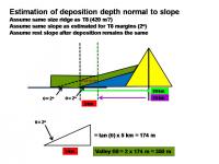
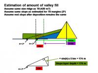
Assuming the angle of repose for the eroded material and the deposited material is the same (2 degrees), trigonometry (uh-oh, math) can estimate the depth of the deposited materials. The key is that after deposition the margins have pulled back 5 km. (This result is independent of the actual ridge height). For a 5 km pullback and 2 degree slope, we get an estimate of 350 m of deposited organics in the valley. The thickness of the organic deposit blanket on the slope is approximately 175 m. The numbers are pretty close (actually spot-on) for the estimated 200 m of organics on the surface of Titan. -Mike -------------------- Some higher resolution images available at my photostream: http://www.flickr.com/photos/31678681@N07/
|
||||||||||
|
|
|
||||||||||
|
Sep 23 2007, 05:45 AM
Post
#8
|
||||
|
Senior Member Group: Moderator Posts: 2785 Joined: 10-November 06 From: Pasadena, CA Member No.: 1345 |
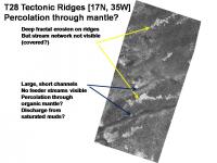
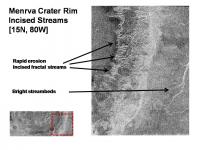
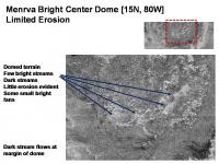
The flanks of the T28 Tectonic Ridges do not show feeder streams. Why not?
The incised ridge tops of the T28 Tectonic Ridge provide evidence for severe erosion. In addition, the the lower valleys show broad and short stream basins. Yet we do not see any intermediate feeder channels. The lower streams resemble the pattern seen in saturated muds like in a slough. Compare this with the Menrva crater rim, which is at the same latitude. The rim is deeply incised with stream patterns. In the figure at right, the central dome of Menrva shows limited erosion. It seems that the central dome is more resistant to erosion than the rim. Either the T28 ridges were covered in material after erosion had taken place, or the rain is able to rapidly percolate through the mantling organic material without causing erosion. Since it is at the same latitude as the Menrva crater rim, it seems likely that the rain that carved the Menrva rim also fell on the T28 Tectonic Ridges. Thus it seems that the rain is able to percolate through the organic mantle, perhaps flowing as undermantle streams until it hits the valleys and has sufficient volume and flow to clear the valley streambeds of gook. -Mike -------------------- Some higher resolution images available at my photostream: http://www.flickr.com/photos/31678681@N07/
|
|||
|
|
|
|||
|
Oct 11 2008, 12:59 PM
Post
#9
|
|
|
Senior Member Group: Moderator Posts: 2785 Joined: 10-November 06 From: Pasadena, CA Member No.: 1345 |
The E-W Mountains on Titan are due to compessional tectonics!
QUOTE Mountains on Titan Presentation Time: Monday, 10:40 a.m. - 10:50 a.m. Giuseppe Mitri1, M. T. Bland2, R. M. C. Lopes1, J. Radebaugh3, A. P. Showman2, J. I. Lunine2, Cassini RADAR Team 1Jet Propulsion Laboratory, California Institute of Technology, 2Department of Planetary Sciences and Lunar and Planetary Laboratory, University of Arizona, 3Department of Geological Sciences, Brigham Young University. Presentation Number: 34.02 The Cassini Radar instrument has observed mountainous topography on Saturns moon Titan both as isolated blocks and chains. Here we report on the geological interpretation of mountain chains discovered during the T8 (October 2005) and T43 Cassini flybys (May 2008). The area imaged during the T43 flyby shows parallel mountain chains with adjacent plains regions. We interpret mountains on this area as hinge lines of long-wavelength cylindrical lithospheric folds resulting from lithospheric shortening due to north-south compression. The plains in this area are likely sedimentary accumulation regions of organic materials. Using the radarclinometric technique we found that the maximum topographic height of mountains relative to surrounding plains is ~2 km. We simulate the two-dimensional compressional crustal deformation of Titans ice-I shell using the Tekton finite-element code. The model considers elastic-viscous-plastic and composite rheologies of the water ice. We demonstrate that compressional crustal deformation of the ice-I shell of Titan can produce topographic height of several kilometers for high temperature gradients in the ice-I shell (order of 10 K km-1), corresponding to an ancient high heat flux from the interior. We find that the mountains experience moderate viscous relaxation over 10E8 - 10E9 yr. We also demonstrate that folding can occur as consequence of global radial contraction during the partial freezing of a subsurface ocean and lithospheric shortening. Consistent with this scenario, Cassini Radars determination of Titans spin rate offset from synchronous rotation suggests that the ice-I shell is decoupled from the interior by a subsurface ocean. Extensional tectonism is observed on almost all icy moons of the outer solar system, but we have little evidence of compressional tectonism on icy satellites. If in fact these features are due to compressional tectonism, then Titan is the only icy moon on which compression features prominently in the style of tectonism. This will be presented live on the web here. Link to some UMSF discussion here (Equatorial Sand Seas thread, post 332) -Mike -------------------- Some higher resolution images available at my photostream: http://www.flickr.com/photos/31678681@N07/
|
|
|
|
|
Oct 11 2008, 01:27 PM
Post
#10
|
|
|
Senior Member Group: Members Posts: 3516 Joined: 4-November 05 From: North Wales Member No.: 542 |
Interesting! "Titan is the only icy moon on which compression features prominently ." Also the only icy moon with a massive atmosphere producing large scale erosion and transport of materials. You know what I'm going to say - migrating poles.
|
|
|
|
|
Oct 13 2008, 10:24 PM
Post
#11
|
|
|
Senior Member Group: Moderator Posts: 2785 Joined: 10-November 06 From: Pasadena, CA Member No.: 1345 |
QUOTE linkback: http://www.unmannedspaceflight.com/index.p...st&p=128592 OT for a 'lakes' thread but from the same conference session, an note about compressional tectonism on Titan, unique among icy moons. Secular global contraction does not produce tectonic folds with preferred directions. De-spinning can, but in the wrong sense for those observed. (It favours NS rather than EW fold ridges) We see EW ones, exemplified by T8 radar. A questioner made the point that we are missing something, and the speaker did not cotradict that. My suggestion is already on record here so I won't sound off again. It was pretty neat to see the comparison/contrast of Titan with Ganymede. (Ganymede had a "runaway thermal effect" while Titan just cooled down). It was very cool to see that a high crustal temperature gradient could produce the tectonic undulations observed on Titan. [Gotta ask here, but maybe the tectonic undulations fit better with the N-S undulations rather than the E-W tectonic ridges?] I did start wondering if maybe there could be an even larger harmonic that could be defining the wider basins on Titan surface. Maybe Fensal and Aztlan are the low points of the meta-harmonic and Quivira is the high point of the meta-harmonic. Superimposed on this pattern is the "shorter" wavelength 50 km E-W tectonic ridge harmonics. This is real similar to the Showman Ganymede model, just differing by a few orders of magnitude - smaller thrust faults were proposed as the finer grooves on Ganymede. Extending it out even more, could some of the larger "blobs" be parts where the 2D harmonics combined to broad maximal amplitude? (Adiri, Xanadu, some of the large blobby bright masses on the trailing side of Titan.) Just a thought....Some of the bright/dark patterns seem to almost look like symmetrical interference patterns. (Anything outside the equatorial zone is going to be faded out and not as evident). -Mike -------------------- Some higher resolution images available at my photostream: http://www.flickr.com/photos/31678681@N07/
|
|
|
|
 |

|
Lo-Fi Version | Time is now: 19th April 2024 - 10:03 PM |
|
RULES AND GUIDELINES Please read the Forum Rules and Guidelines before posting. IMAGE COPYRIGHT |
OPINIONS AND MODERATION Opinions expressed on UnmannedSpaceflight.com are those of the individual posters and do not necessarily reflect the opinions of UnmannedSpaceflight.com or The Planetary Society. The all-volunteer UnmannedSpaceflight.com moderation team is wholly independent of The Planetary Society. The Planetary Society has no influence over decisions made by the UnmannedSpaceflight.com moderators. |
SUPPORT THE FORUM Unmannedspaceflight.com is funded by the Planetary Society. Please consider supporting our work and many other projects by donating to the Society or becoming a member. |
|